7-27-14
Alta
Mountain is a favorite of mine. The long ridge walk to the summit is
among the best. I hiked up in 2008 and walked into the clouds. Nearly
zero visibility from the summit. It had been eleven years since I had
been up on a clear day. Way too long. It was going to be a hot day and
I had a reasonably early start. I was out the door at 7:00 am. Off I-90
at the Kachess Lake exit and pavement to Lake Kachess State Part. The
next mile of dirt was in good shape. The last three miles was in poor
shape. Some good stretches but some spots where I had to nearly stop to
bounce through the pot holes. The first row of the 2760' parking lot
was mostly full and the next one was empty. Not as crowded as I was
expecting.
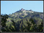
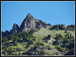
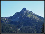
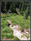
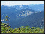
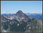
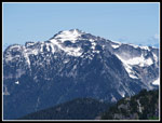
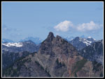
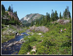
I was on the trail at 8:37 am. It was a little cool though that did not last long. I started just ahead of a group and sped up to stay ahead. All the side creeks were running but I made it over them all with dry feet. The first 2.5 miles has minimal elevation gain and goes fast. Lots of forest then a number of brushy meadows. The morning dew brushed off on my pants though it did not take long to dry out as the temperature rose. From several of the meadows Hibox Mountain appears high above. The route up Hibox looks even steeper than it is.
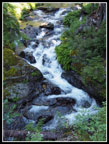
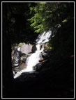
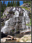
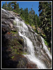
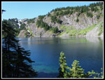
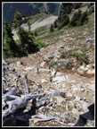
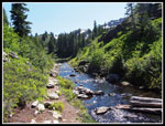
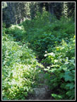
At the end of the valley the easy grade came to an end. The next 1.5 miles took me longer than the first 2.5. The nice trail below gives way to roots, rocks, and running water. The climb to the lake was just as bad if not worse than I recalled. It's the price you pay for the really good stuff up higher. The waterfall along the way was running well though not so high as to make crossing the creek there hard. I was sweating a lot when I finally topped out at Rachel Lake.
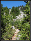
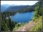
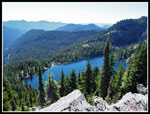
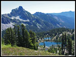
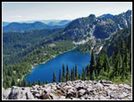
I stopped at the lake for food, water, and sun screen. I took 1:51, reaching the 4640' lake at 10:28 am. It is much more effort than the 4 miles with 1900' of gain would suggest. I had not noticed any bugs on the way up but they were out at the lake. Another reason for a short stay. After just ten minutes I was heading uphill once again. There was a small snow patch just above the lake then no more until high on the ridge of Alta Mountain. The route from the lake to the ridge top is short and steep. While it has some loose rock it is much less rough than the section below the lake. It's partly in forest with some open views down to the lake and out to Hibox.
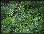
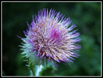
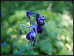
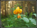
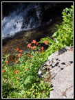
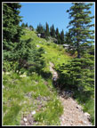
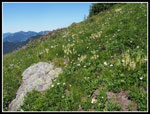
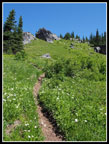
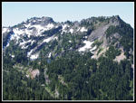
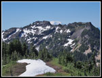
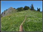
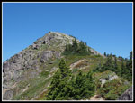
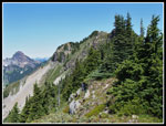
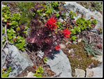
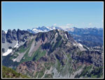
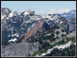
Once on the ridge I took the right hand trail at the junction. This leads to Lila Lakes with a spur heading up the ridge of Alta. The trail is narrow but easy to follow. A short ways on I turned left on the Alta trail. It heads to the base of a steep section of ridge and then goes straight up. No switchbacks at all. Just straight up. It was now getting much warmer and the heat was more of a problem for me than the steepness. The views just get better and better the higher I climbed. The summit is nice but the views are great all along the ridge. After several hundred feet of gain in a short distance the grade lessens. Lots of wildflowers in bloom. Valerian, asters, lousewort, and some kind of daisies predominated with some glacier lilies in places. The berries are just forming. It will be at least a month or more before they are ripe.
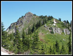
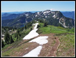
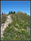
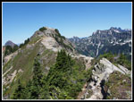
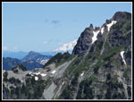
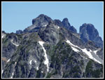
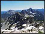
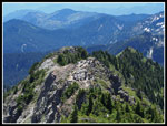
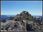
As I climbed I spotted another group ahead of me. I slowly narrowed the gap. There are several snow patches on the ridge top. None are a problem. They will be gone very soon. They did provide a little natural cooling this day. The ridge has several false summits. I remembered that the real summit does not come into view until well along the ridge. The only spot with some exposure is after dropping down to the last saddle. The boot path back to the ridge top just before the summit is steep, narrow, and a little loose. It is not easy trail walking but not a difficult scramble. One group passed me heading down on this section. not a great place to pass.
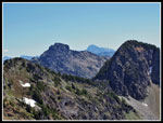
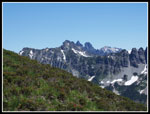
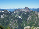
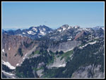
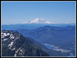
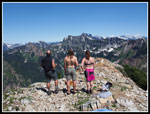
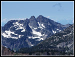
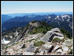
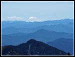
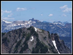
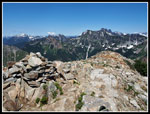
At the summit I met the group I had been trailing on the ridge. Those five were the only folks on top during my nearly two hour stay. I arrived at 12:18 pm. There was very little breeze and lots of bugs on top. They were not too aggressive and there were no biting flies making it okay. I did put on bug spray to ward them off at least a little. The views really are spectacular from the 6250' summit. Much of the PCT is visible from the Kendall Katwalk onto near Park Lakes. Both Mt. Rainier and Mt. Adams were clear of clouds. Half of Glacier Peak is seen to the north. Mt. Stuart was visible from the ridge top but on the summit it is right behind Three Queens. Just a fraction of the summit can be seen. I did notice a clear look at The Citadel. That is a peak I don't see often.
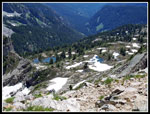
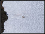
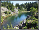
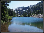
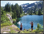
The other folks were camping at Rampart Lakes and day hiked over. They also pointed out a mountain goat resting on the snow far below. They hung around for about an hour and I then had another 45 minutes to myself. The eight foot tall summit cairn I saw on my 2008 visit has been dismantled. At 2:00 pm I packed up and headed down. Before too long I met a group heading up. Then came another. There were four or five groups heading to the summit in a short distance It must have been pretty crowded. So many great views to photograph along the ridge. I took my time. Back at the junction above Rachel Lake I chose to go straight on the route to Rampart Lakes. It only took me about 15 minutes to reach the lakes. There are several snow patches surviving along the way. I went past the first ponds then lakes and climbed up to a larger lake. It was now very hot and a little shade was appreciated.
As I headed back I heard a loud "splash" and found the summit hikers jumping off a big rock into the lake. I stayed to get a few photos of the fun. It was now 3:40 pm and I still had 5 miles with a lot of steep rocky and rooty trail to hike down. Three hikers left Rampart Lakes just ahead of me. I followed them back to the Rachel Lake junction and down to the trail to the lake. As I left the lake they were just behind me. Heading down I passed several groups still coming up. I soon caught up with two other hikers. We took a wrong turn and when we returned to the trail the other threesome was there. I really did not want to follow two groups down. It is difficult to pass on the narrow route. Instead I just took off. It's a real knee pounder if you hike it fast. I passed one more group just below the waterfall. It was an interesting experience Not one I plan to repeat.
After the steeps the flat section went by very fast. I reached the car at 5:45 pm having taken 1:24 to descend from the lake. The day turned out very well. Lakes, peaks, some wildflowers, and amazing views filled the day. Considering all the hours on the ridge and summit without any shade, I could have asked for a little less heat. Still, the clear blue sky made for all the great views. On my last trip it was cool and I could not see a thing from inside the clouds. All in all, and excellent day in the mountains.
Click on thumbnails to get
larger pictures.
Trips - 2014
Home
I was on the trail at 8:37 am. It was a little cool though that did not last long. I started just ahead of a group and sped up to stay ahead. All the side creeks were running but I made it over them all with dry feet. The first 2.5 miles has minimal elevation gain and goes fast. Lots of forest then a number of brushy meadows. The morning dew brushed off on my pants though it did not take long to dry out as the temperature rose. From several of the meadows Hibox Mountain appears high above. The route up Hibox looks even steeper than it is.
At the end of the valley the easy grade came to an end. The next 1.5 miles took me longer than the first 2.5. The nice trail below gives way to roots, rocks, and running water. The climb to the lake was just as bad if not worse than I recalled. It's the price you pay for the really good stuff up higher. The waterfall along the way was running well though not so high as to make crossing the creek there hard. I was sweating a lot when I finally topped out at Rachel Lake.
I stopped at the lake for food, water, and sun screen. I took 1:51, reaching the 4640' lake at 10:28 am. It is much more effort than the 4 miles with 1900' of gain would suggest. I had not noticed any bugs on the way up but they were out at the lake. Another reason for a short stay. After just ten minutes I was heading uphill once again. There was a small snow patch just above the lake then no more until high on the ridge of Alta Mountain. The route from the lake to the ridge top is short and steep. While it has some loose rock it is much less rough than the section below the lake. It's partly in forest with some open views down to the lake and out to Hibox.
Once on the ridge I took the right hand trail at the junction. This leads to Lila Lakes with a spur heading up the ridge of Alta. The trail is narrow but easy to follow. A short ways on I turned left on the Alta trail. It heads to the base of a steep section of ridge and then goes straight up. No switchbacks at all. Just straight up. It was now getting much warmer and the heat was more of a problem for me than the steepness. The views just get better and better the higher I climbed. The summit is nice but the views are great all along the ridge. After several hundred feet of gain in a short distance the grade lessens. Lots of wildflowers in bloom. Valerian, asters, lousewort, and some kind of daisies predominated with some glacier lilies in places. The berries are just forming. It will be at least a month or more before they are ripe.
As I climbed I spotted another group ahead of me. I slowly narrowed the gap. There are several snow patches on the ridge top. None are a problem. They will be gone very soon. They did provide a little natural cooling this day. The ridge has several false summits. I remembered that the real summit does not come into view until well along the ridge. The only spot with some exposure is after dropping down to the last saddle. The boot path back to the ridge top just before the summit is steep, narrow, and a little loose. It is not easy trail walking but not a difficult scramble. One group passed me heading down on this section. not a great place to pass.
At the summit I met the group I had been trailing on the ridge. Those five were the only folks on top during my nearly two hour stay. I arrived at 12:18 pm. There was very little breeze and lots of bugs on top. They were not too aggressive and there were no biting flies making it okay. I did put on bug spray to ward them off at least a little. The views really are spectacular from the 6250' summit. Much of the PCT is visible from the Kendall Katwalk onto near Park Lakes. Both Mt. Rainier and Mt. Adams were clear of clouds. Half of Glacier Peak is seen to the north. Mt. Stuart was visible from the ridge top but on the summit it is right behind Three Queens. Just a fraction of the summit can be seen. I did notice a clear look at The Citadel. That is a peak I don't see often.
The other folks were camping at Rampart Lakes and day hiked over. They also pointed out a mountain goat resting on the snow far below. They hung around for about an hour and I then had another 45 minutes to myself. The eight foot tall summit cairn I saw on my 2008 visit has been dismantled. At 2:00 pm I packed up and headed down. Before too long I met a group heading up. Then came another. There were four or five groups heading to the summit in a short distance It must have been pretty crowded. So many great views to photograph along the ridge. I took my time. Back at the junction above Rachel Lake I chose to go straight on the route to Rampart Lakes. It only took me about 15 minutes to reach the lakes. There are several snow patches surviving along the way. I went past the first ponds then lakes and climbed up to a larger lake. It was now very hot and a little shade was appreciated.
As I headed back I heard a loud "splash" and found the summit hikers jumping off a big rock into the lake. I stayed to get a few photos of the fun. It was now 3:40 pm and I still had 5 miles with a lot of steep rocky and rooty trail to hike down. Three hikers left Rampart Lakes just ahead of me. I followed them back to the Rachel Lake junction and down to the trail to the lake. As I left the lake they were just behind me. Heading down I passed several groups still coming up. I soon caught up with two other hikers. We took a wrong turn and when we returned to the trail the other threesome was there. I really did not want to follow two groups down. It is difficult to pass on the narrow route. Instead I just took off. It's a real knee pounder if you hike it fast. I passed one more group just below the waterfall. It was an interesting experience Not one I plan to repeat.
After the steeps the flat section went by very fast. I reached the car at 5:45 pm having taken 1:24 to descend from the lake. The day turned out very well. Lakes, peaks, some wildflowers, and amazing views filled the day. Considering all the hours on the ridge and summit without any shade, I could have asked for a little less heat. Still, the clear blue sky made for all the great views. On my last trip it was cool and I could not see a thing from inside the clouds. All in all, and excellent day in the mountains.
 Box Creek |
 Bunchberries |
 Thistle |
 Blue Flower |
 Hibox Mountain |
 Hibox Close Up |
 Tiger Lily |
 Dark & Light |
 Waterfall |
 Columbine |
 Falls Shot |
 Hibox Again |
 At Rachel Lake |
 Route To Ridge |
 Above Rachel Lake |
 Rachel From Ridge |
 Steep Climb |
 More Steep Uphill |
 Lousewort |
 Narrow Trail |
 Rampart Ridge |
 A False Summit Ahead |
 Snow Patch |
 Flower Show |
 Snoqualmie Pass |
 Lila Lakes |
 Grade Moderates |
 Hiker In Sight |
 Summit In Sight |
 Mt. Stuart |
 Indian Paintbrush |
 Next False Summit |
 Chikamin Peak |
 Mt. Daniel |
 Ridge To Summit |
 Alaska Lake |
 Snoqualmie Pass Peaks |
 Mt. Rainier |
 Mt. Thompson |
 Alta Summiteers |
 Chair Peak |
 Big Snow Mountain |
 Kendall Katwalk |
 Half Glacier Peak |
 Chikamin Summit |
 Ridge Up |
 Lakes Below |
 Three Queens |
 Mt. Adams |
 The Citadel |
 Hikers On Ridge |
 Summit View North |
 Goat On Snow |
 Huckleberry Mountain |
 Scramble Section |
 Back On Ridge Top |
 Rachel Again |
 Rampart Creek |
 A Rampart Lake |
 Bigger Lake |
 Dive In! |
 Alta From Ramparts |
 Brushy Trail |
Trips - 2014
Home