6-29-14
Day
two of my Teanaway weekend
began with clouds and some sun breaks. I broke camp just off the
Stafford Creek Road and headed up the
NF Teanaway Road for a 9:00 am meeting with Craig Romano at the DeRoux
Campgrounds. On the way I was flagged down to help jump a dead battery.
I arrived just before Craig. We were the first cars at DeRoux. We left
Craig's car at DeRoux and drove mine to the Ingalls Trailhead at the
end of the road. I've done this loop solo with a road walk and having a
car shuttle is much better. By the time we were on the trail it was
9:45 am.
As we started hiking we made a funny discovery. Back in mid June 2005 I signed up for a WTA wildflower hike to Bean Creek Basin. It was led by Karen Sykes. We met at Beverly Campgrounds and Karen decided she was not comfortable having the group cross Bean Creek with the spring snow melt. I suggested the Esmerelda - DeRoux loop and that is what we did. It turns out that Craig was on that trip too. We had met, however briefly, some nine years earlier and never knew it. It is a small world.
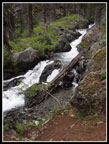
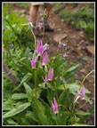
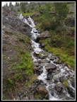
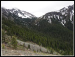
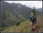
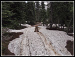
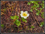
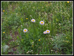
I was on this trail just three weeks earlier for a scramble up Fortune Peak. A lot of snow has melted in since then. I had lightweight hiking shoes and managed to get across the now much smaller creek crossings with dry feet. There was a pretty good wildflower display with shooting stars the primary flower once again. It seemed like every creek was lined with them. This trail is very gently graded. The first part of the old road/trail out of the parking lot is likely the steepest. The talk of a clear day was quickly put to rest. It was dark and a little chilly. Short sleeves were fine while climbing however.
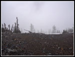
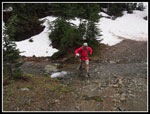
We passed the point where the trail was lost under snow in early June. In fact, the trail is nearly snow free to Fortune Creek Pass. At the junction where the County Line Trail heads up to the pass above Lake Ann we stopped. Craig had not been there and was interested in exploring. I did not think there would be any views with the low clouds but I agreed. The trail is just as rocky as I remembered it. Part way up we hit snow. Soon it was mostly continuous. There were plenty of footprints to follow. As we rose the wind began to pick up. We had passed a big group of Boy Scouts coming down after camping at Lake Ann. Now we met more folks heading down. Everyone seemed to have had a good time.
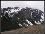
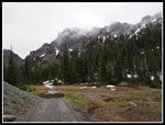
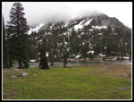
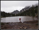
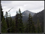
The pass is at about 6500' and we were in the clouds. Lake Ann was right below but we could not see anything. Fortune and Ingalls Peaks were likewise lost in a sea of white. It was quite cold with the steady wind. We hung around for awhile as Craig hoped for a break in the clouds. We had a few second look down to the basin below but never did see Lake Ann. soon enough I was ready to get moving again. It was nearly a mile each way up to the pass. From the junction we has an easy hike over to Fortune Creek Pass at about 6000'. One good sized snow patch just before the pass that will be gone soon. We had some views out from the pass though not far. Hawkins and Esmerelda were partly hidden by clouds.
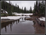
Now it was time to descend. The switchbacking trail loses nearly one thousand feet to where it meets the Fortune Creek Road. The trail is snow free. The road in the deep valley was a different matter. In places it is bare. In forested spots it still has several feet of snow covering it. The road fords the creek several times. The water level is pretty high. Not tough to get across. Just a challenge with dry feet. Craig has less of a problem with dunking his feet. I work harder to keep mine dry. One spot had a small slide this winter leaving broken trees in its wake. I was amazed to see vehicle tracks in the deep and at times steep snow. I would not have thought it would be drivable so early.
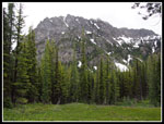
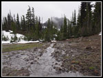
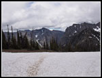
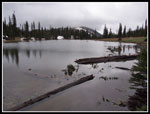
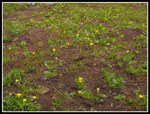
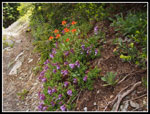
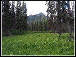
We were soon back in the clouds as we neared the high point. Gallagher Head Lake is just across the broad nearly flat saddle and drains to the south. We were approaching from the north. The ground was partly snow covered and partly bare. We left the road at the lake and took a short walk to the shore. Time for the last of my lunch. The lake is snow free though there are patches on the southeast side. It was chilly bit not freezing. We could see bright red DeRoux Peak in the distance down the lake. Hawkins were still partly in the clouds. The boggy meadows before and at the lake were filled with blooming marsh marigolds. There were glacier lilies and shooting stars too. The early flowers are going strong. I had switched to a long sleeve short at Lake Ann Pass and needed a jacket now. It might be summer but it still felt like the end of winter.
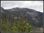
We again waited, hoping for the expected afternoon clearing. It was not to be. At about 3:00 pm we continued on. We soon left the road and crossed the outlet creek on a bridge that was built after our 2005 visit. I was afraid the trail might be hard to follow on snow but there were plenty of footprints. We headed on around Esmerelda Peaks and began to descend. Soon we were completely off snow. We did not have any below in the forest. A party suddenly showed up on the trail ahead of us. When they stopped we found out they had scrambled West Esmerelda Peak. It was very rocky on the scree slopes. Snow only remained nearer to the top.
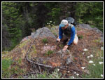
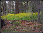
The trail drops with very gently switchbacks to the valley below. Lots more shooting stars on the rocky slope. Our final creek crossing is the biggest one of the loop. It can be a torrent in May and June. I took Craig's lead and just slogged on through. My feet were soaked but they did dry out pretty well later. The last three miles was mostly a forest walk. Several patches of wildflowers, especially a big bunch of Columbia Lewisia. The crossings of DeRoux Creek and the NF Teanaway River are on bridges. We reached the trailhead at about 5:30. Though the skies threatened much of the day we had only one short bit of drizzle.
I had a great weekend. Two hikes with Craig to a 7200' summit and a loop trip with a lake in the middle. Lots of talk of hiking and many photographs. It had been nine years since we had done the loop trip. Navaho I seem to get to every year or two. Some sun and views on day one and a dark and cloudy theme on day two. It was all good. By the time we drove to my car the Ingalls lot was mostly empty. A good time was had by all.
Click on thumbnails to get
larger pictures.
Trips - 2014
Home
As we started hiking we made a funny discovery. Back in mid June 2005 I signed up for a WTA wildflower hike to Bean Creek Basin. It was led by Karen Sykes. We met at Beverly Campgrounds and Karen decided she was not comfortable having the group cross Bean Creek with the spring snow melt. I suggested the Esmerelda - DeRoux loop and that is what we did. It turns out that Craig was on that trip too. We had met, however briefly, some nine years earlier and never knew it. It is a small world.
I was on this trail just three weeks earlier for a scramble up Fortune Peak. A lot of snow has melted in since then. I had lightweight hiking shoes and managed to get across the now much smaller creek crossings with dry feet. There was a pretty good wildflower display with shooting stars the primary flower once again. It seemed like every creek was lined with them. This trail is very gently graded. The first part of the old road/trail out of the parking lot is likely the steepest. The talk of a clear day was quickly put to rest. It was dark and a little chilly. Short sleeves were fine while climbing however.
We passed the point where the trail was lost under snow in early June. In fact, the trail is nearly snow free to Fortune Creek Pass. At the junction where the County Line Trail heads up to the pass above Lake Ann we stopped. Craig had not been there and was interested in exploring. I did not think there would be any views with the low clouds but I agreed. The trail is just as rocky as I remembered it. Part way up we hit snow. Soon it was mostly continuous. There were plenty of footprints to follow. As we rose the wind began to pick up. We had passed a big group of Boy Scouts coming down after camping at Lake Ann. Now we met more folks heading down. Everyone seemed to have had a good time.
The pass is at about 6500' and we were in the clouds. Lake Ann was right below but we could not see anything. Fortune and Ingalls Peaks were likewise lost in a sea of white. It was quite cold with the steady wind. We hung around for awhile as Craig hoped for a break in the clouds. We had a few second look down to the basin below but never did see Lake Ann. soon enough I was ready to get moving again. It was nearly a mile each way up to the pass. From the junction we has an easy hike over to Fortune Creek Pass at about 6000'. One good sized snow patch just before the pass that will be gone soon. We had some views out from the pass though not far. Hawkins and Esmerelda were partly hidden by clouds.
Now it was time to descend. The switchbacking trail loses nearly one thousand feet to where it meets the Fortune Creek Road. The trail is snow free. The road in the deep valley was a different matter. In places it is bare. In forested spots it still has several feet of snow covering it. The road fords the creek several times. The water level is pretty high. Not tough to get across. Just a challenge with dry feet. Craig has less of a problem with dunking his feet. I work harder to keep mine dry. One spot had a small slide this winter leaving broken trees in its wake. I was amazed to see vehicle tracks in the deep and at times steep snow. I would not have thought it would be drivable so early.
We were soon back in the clouds as we neared the high point. Gallagher Head Lake is just across the broad nearly flat saddle and drains to the south. We were approaching from the north. The ground was partly snow covered and partly bare. We left the road at the lake and took a short walk to the shore. Time for the last of my lunch. The lake is snow free though there are patches on the southeast side. It was chilly bit not freezing. We could see bright red DeRoux Peak in the distance down the lake. Hawkins were still partly in the clouds. The boggy meadows before and at the lake were filled with blooming marsh marigolds. There were glacier lilies and shooting stars too. The early flowers are going strong. I had switched to a long sleeve short at Lake Ann Pass and needed a jacket now. It might be summer but it still felt like the end of winter.
We again waited, hoping for the expected afternoon clearing. It was not to be. At about 3:00 pm we continued on. We soon left the road and crossed the outlet creek on a bridge that was built after our 2005 visit. I was afraid the trail might be hard to follow on snow but there were plenty of footprints. We headed on around Esmerelda Peaks and began to descend. Soon we were completely off snow. We did not have any below in the forest. A party suddenly showed up on the trail ahead of us. When they stopped we found out they had scrambled West Esmerelda Peak. It was very rocky on the scree slopes. Snow only remained nearer to the top.
The trail drops with very gently switchbacks to the valley below. Lots more shooting stars on the rocky slope. Our final creek crossing is the biggest one of the loop. It can be a torrent in May and June. I took Craig's lead and just slogged on through. My feet were soaked but they did dry out pretty well later. The last three miles was mostly a forest walk. Several patches of wildflowers, especially a big bunch of Columbia Lewisia. The crossings of DeRoux Creek and the NF Teanaway River are on bridges. We reached the trailhead at about 5:30. Though the skies threatened much of the day we had only one short bit of drizzle.
I had a great weekend. Two hikes with Craig to a 7200' summit and a loop trip with a lake in the middle. Lots of talk of hiking and many photographs. It had been nine years since we had done the loop trip. Navaho I seem to get to every year or two. Some sun and views on day one and a dark and cloudy theme on day two. It was all good. By the time we drove to my car the Ingalls lot was mostly empty. A good time was had by all.
 Cascading River |
 Meadow & Peaks |
 Shooting Stars |
 More Creeks |
 Cloudy Pass |
 Trail/Creek |
 Fortune Creek Pass |
 Craig At Pass |
 Heading That Way |
 Descending |
 Junction |
 Creek Hopping |
 Deeper Snow |
 Puddle Reflection |
 Hawkins In Clouds |
 Marsh Marigold |
 Gallagher Head Lake |
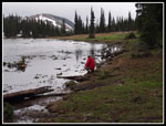 Craig At Shore |
 Esmerelda In Clouds |
 Glacier Lilies |
 Leaving Lake |
 Koppen Mountain |
 Nice Colors |
 Iron Peak |
 Craig At Work |
 Asters |
 Peak & Meadow |
 Great Color |
Trips - 2014
Home