6-14-14
Gary
was free for a hike. The
weather was awful. We chose to head way east. For a number of years the
Fourth of July Trail up Icicle Ridge was a spring staple. Over 4000' of
gain on a south facing slope that melts out early. I checked my trip
log and I had not done it since 2000. To my surprise, Gary had never
hiked it. That settled that. We met early at 6:30 am in Bothell. We
headed east on Highway 2 to Leavenworth. By 8:40 am we were parked and
on our way. It was windy on the drive up the valley. We hoped it would
not be too windy high on the slope. Most of the wildflowers near the
bottom were done. The show improved as we gained elevation.
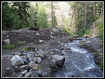
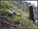
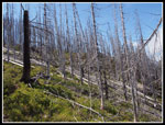
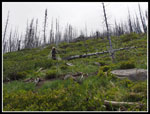
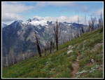
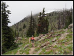
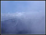
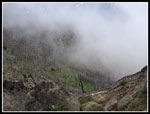
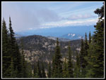
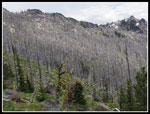
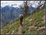
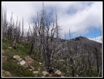
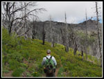
My last visit was before the fire. I recalled lots of green forest. There is now a lot of silver snags. A short way in we came to the first creek crossing. It was clear that a washout had occurred in the last 14 years. Lots of dirt has slid. The crossing was no problem. A large group began just ahead of us. They stayed ahead for quite a while. We kept up a steady pace with a number of photo stops. The top of Cashmere Mountain, across the valley, was in the clouds much of the day. Most of the views were not. As we climbed the views improved. This trail gains nearly 850 feet per mile but does not seem that steep. There are very few steps and for the most part the tread is smooth. We noticed the rocks far more on the way down than on the way up.
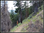
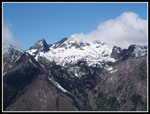
While there is still some forest left, this is not a trail I would do on a hot summer day. It was perfect on this partly sunny but cool spring day. The wind blew at times and it was cold. The elevation gain kept me warm. After a few miles the heat won out and I changed into a short sleeve shirt and zipped off my pants legs. We passed some of the big group and were passed by a few other folks. Looking south it as soon easy to pick out Colchuck Col above Colchuck Lake. Clouds hung right near the top of Colchuck Peak and Dragontail Peak on either side of the col. The top of Mt. Stuart was in the clouds and remained there all day.
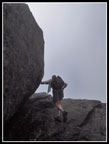
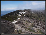
One of my longest memories of the trail was a tree at a small creek crossing high on the ridge. For some reason I looked behind it many years ago and found an old circular canteen in a canvas holder hanging on the tree. It was still there on my 2000 visit. The tree is now burned up. The short remains of the tree had a rusted metal cup sitting on it. The canteen is long gone. The trail became a little rocky high up. The grade remained constant. I still can't believe that there is 4750' of gain to the old lookout site. The trail gains elevation steadily but is never all that steep. We began to see some snow patches above and a few minutes later we reached the ridge top. We had to cross a short 40' of so of snow. That was it for snow to the Icicle Ridge Trail junction. A few folks were waiting there for the rest of their group.
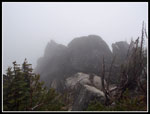
We took a left turn and headed uphill. Quickly the dirt gave way to snow. Even with low cut hiking shoes we did not bother to stop and put on gaiters. In a few minutes we reached the lookout spur junction. We followed footprints uphill. We were now in the clouds and could not see the lookout though it as just above us. Just east of the summit block we left snow and met a number of folks. It was windless and much warmer. Surprisingly warm at just over 7000'. We followed the route around the block and immediately walked into the deep freeze. A strong freezing wind greeted us. There was rime ice on the rocks. It was short sleeve weather 30 feet away on the east side. We wound around to the south where there is access to the very top. We did not bother with the last six feet. It requires grabbing an old metal post and hauling yourself up. It was frigid and I touched the top. Good enough. We headed back towards the warm side.
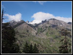
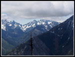
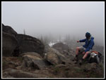
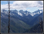
Gary met an old friend at the trailhead. Part of the big group. They met again on the freezing west side of the summit. Still in short sleeves and shorts I about froze as they caught up. I put on a jacket. Then I headed for the oasis on the east side. Around the corner and the temperature went up by 30 degrees. Zero wind. We took an hour to have a long lunch. We had slowed down a little the last mile up hoping the clouds might burn off or blow away. We stretched out our lunch for the same reason. We did have a few short openings in the clouds. When overhead the warmth of the sun was palpable. One moment we could not see down to the saddle on the ridge. The next we could and then see over to the Stuart Range. Then back into the clouds. Looking up we could see wisps of clouds barreling right over us at very high speed.
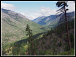
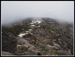
We reached the summit at 12:15 pm. We did not head down until 1:30 pm. I had my pants legs back on plus light gloves and my jacket on. It was a bit cold back in the wind though it was blowing much lighter on the ridge east of the lookout site. Gary led a short detour over to the north side. We had a small break in the clouds and could see out to some snowy peaks to the northwest. It looked like we picked out the bottom of a cloudy Glacier Peak too. We headed back to the junction and then down the Fourth Of July Creek Trail. Somehow the smooth trail became rockier on the way down. Not sure how that happened. It was a lot longer too. We took 3:35 minutes coming up. That included a lot of photo stops and just slowing down hoping the clouds would clear. Coming down we took 3:25. That included some hunting for wildflowers. Still, not much difference in time.
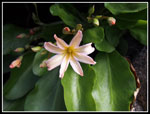
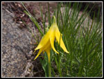
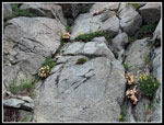
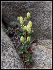
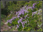
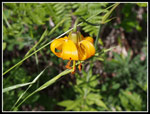
On the way up we saw some Tweedy's Lewisia off the trail. I had never seen it on the trail. A trip report from earlier in the week showed it. Coming down we did a little more exploring and found more. Unfortunately, it was just past its prime. A week earlier would have been great. We also noticed more Tweedy's right on the trail that we missed on the way up. Same for a single scarlet gilia in bloom and several tiger lilies. We continued to see folks heading up much of our way down. The last several miles really seemed to take a long time. Finally, at 4:55 we reached the trailhead. There is no bathroom and no picnic table so this trail currently does not require a NW Forest Pass for parking.
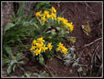
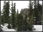
This turned out to be a great hike. I had not done it in 14 years and it was all new to Gary. It looked much different since the fire. The fire was long enough ago that grass and wildflowers now cover the ground. many trees have gone silver. Not much soot remains. The route is beautiful in a much different way than I remembered it. We were a little late for the best wildflower show though we had a very good assortment in bloom. It was never hot but I enjoyed a little sun and comfortable weather for the long climb. So long as it's not too hot, this is a great conditioning hike. It's not steep but there is no way to get around the 4750' gained on the way up. There is almost no uphill on the way back. I hope this trip finds its way back onto my spring schedule in the future.
Click on thumbnails to get
larger pictures.
Trips - 2014
Home
My last visit was before the fire. I recalled lots of green forest. There is now a lot of silver snags. A short way in we came to the first creek crossing. It was clear that a washout had occurred in the last 14 years. Lots of dirt has slid. The crossing was no problem. A large group began just ahead of us. They stayed ahead for quite a while. We kept up a steady pace with a number of photo stops. The top of Cashmere Mountain, across the valley, was in the clouds much of the day. Most of the views were not. As we climbed the views improved. This trail gains nearly 850 feet per mile but does not seem that steep. There are very few steps and for the most part the tread is smooth. We noticed the rocks far more on the way down than on the way up.
While there is still some forest left, this is not a trail I would do on a hot summer day. It was perfect on this partly sunny but cool spring day. The wind blew at times and it was cold. The elevation gain kept me warm. After a few miles the heat won out and I changed into a short sleeve shirt and zipped off my pants legs. We passed some of the big group and were passed by a few other folks. Looking south it as soon easy to pick out Colchuck Col above Colchuck Lake. Clouds hung right near the top of Colchuck Peak and Dragontail Peak on either side of the col. The top of Mt. Stuart was in the clouds and remained there all day.
One of my longest memories of the trail was a tree at a small creek crossing high on the ridge. For some reason I looked behind it many years ago and found an old circular canteen in a canvas holder hanging on the tree. It was still there on my 2000 visit. The tree is now burned up. The short remains of the tree had a rusted metal cup sitting on it. The canteen is long gone. The trail became a little rocky high up. The grade remained constant. I still can't believe that there is 4750' of gain to the old lookout site. The trail gains elevation steadily but is never all that steep. We began to see some snow patches above and a few minutes later we reached the ridge top. We had to cross a short 40' of so of snow. That was it for snow to the Icicle Ridge Trail junction. A few folks were waiting there for the rest of their group.
We took a left turn and headed uphill. Quickly the dirt gave way to snow. Even with low cut hiking shoes we did not bother to stop and put on gaiters. In a few minutes we reached the lookout spur junction. We followed footprints uphill. We were now in the clouds and could not see the lookout though it as just above us. Just east of the summit block we left snow and met a number of folks. It was windless and much warmer. Surprisingly warm at just over 7000'. We followed the route around the block and immediately walked into the deep freeze. A strong freezing wind greeted us. There was rime ice on the rocks. It was short sleeve weather 30 feet away on the east side. We wound around to the south where there is access to the very top. We did not bother with the last six feet. It requires grabbing an old metal post and hauling yourself up. It was frigid and I touched the top. Good enough. We headed back towards the warm side.
Gary met an old friend at the trailhead. Part of the big group. They met again on the freezing west side of the summit. Still in short sleeves and shorts I about froze as they caught up. I put on a jacket. Then I headed for the oasis on the east side. Around the corner and the temperature went up by 30 degrees. Zero wind. We took an hour to have a long lunch. We had slowed down a little the last mile up hoping the clouds might burn off or blow away. We stretched out our lunch for the same reason. We did have a few short openings in the clouds. When overhead the warmth of the sun was palpable. One moment we could not see down to the saddle on the ridge. The next we could and then see over to the Stuart Range. Then back into the clouds. Looking up we could see wisps of clouds barreling right over us at very high speed.
We reached the summit at 12:15 pm. We did not head down until 1:30 pm. I had my pants legs back on plus light gloves and my jacket on. It was a bit cold back in the wind though it was blowing much lighter on the ridge east of the lookout site. Gary led a short detour over to the north side. We had a small break in the clouds and could see out to some snowy peaks to the northwest. It looked like we picked out the bottom of a cloudy Glacier Peak too. We headed back to the junction and then down the Fourth Of July Creek Trail. Somehow the smooth trail became rockier on the way down. Not sure how that happened. It was a lot longer too. We took 3:35 minutes coming up. That included a lot of photo stops and just slowing down hoping the clouds would clear. Coming down we took 3:25. That included some hunting for wildflowers. Still, not much difference in time.
On the way up we saw some Tweedy's Lewisia off the trail. I had never seen it on the trail. A trip report from earlier in the week showed it. Coming down we did a little more exploring and found more. Unfortunately, it was just past its prime. A week earlier would have been great. We also noticed more Tweedy's right on the trail that we missed on the way up. Same for a single scarlet gilia in bloom and several tiger lilies. We continued to see folks heading up much of our way down. The last several miles really seemed to take a long time. Finally, at 4:55 we reached the trailhead. There is no bathroom and no picnic table so this trail currently does not require a NW Forest Pass for parking.
This turned out to be a great hike. I had not done it in 14 years and it was all new to Gary. It looked much different since the fire. The fire was long enough ago that grass and wildflowers now cover the ground. many trees have gone silver. Not much soot remains. The route is beautiful in a much different way than I remembered it. We were a little late for the best wildflower show though we had a very good assortment in bloom. It was never hot but I enjoyed a little sun and comfortable weather for the long climb. So long as it's not too hot, this is a great conditioning hike. It's not steep but there is no way to get around the 4750' gained on the way up. There is almost no uphill on the way back. I hope this trip finds its way back onto my spring schedule in the future.
 Creek Crossing |
 Dead & Live Trees |
 Peak In Sight |
 Icicle Creek Valley |
 Penstemon |
 Cashmere Mountain |
 Silver Forest |
 Up Slope |
 Tweedy's Lewisia |
 Open Views |
 Stuart In Clouds |
 Yellow Flowers |
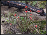 Indian Paintbrush |
 Nearing The Ridge Top |
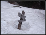 Junction Sign |
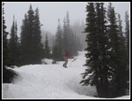 Hiking On Snow |
 Summit Block |
 Heading Out Of Wind |
 Looking Down Ridge |
 Small Clearing |
 Cloudy Stuart Range |
 View? What View? |
 Icicle Ridge Top |
 Lookout Site |
 View Northwest |
 Glacier Lily |
 Silver Trees |
 Colchuck Col |
 Great Views |
 More Tweedy's |
 Flower In Rocks |
 Clouds & Sun |
 Grass & Snags |
 More Penstemon |
 Tiger Lily |
Trips - 2014
Home