4-05-14
Saturday was shaping up to be a dismal day. Rain on the west side, rain
east of the crest, rain everywhere. I was not sure I would
have any time to hike this weekend but I got caught up enough to get
out Saturday. Janet wanted to head east. Neither of us had done
Manastash Ridge so I signed on. The trail is renowned for spring
wildflowers. A report from earlier in the week showed the slight
beginnings of the color show. Even over there it was supposed to rain
later in the day so we met in Bellevue at 7:10 am. Most of the drive
east it rained. Sometimes lightly and near the Cascade crest much
harder. Beyond Easton we began to see some clearing farther east. By
Cle Elum it was looking pretty good. We took exit 101 at Thorp and
followed the directions to the trailhead. Right at the exit, right on
Cove Road in about 2 miles, and then follow Cover Road to th end. 95
miles in about 90 minutes from Bellevue.
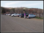
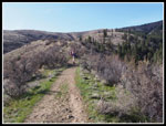
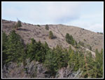
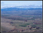
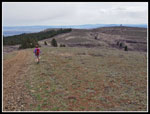
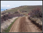
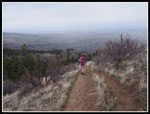
I was very surprised to see we were the 23rd car in the lot. It was only 8:50 am when we started out so this is one popular trailhead. Mostly blue sky overhead though it was cloudy to the north. The ridge route was clearly visible near the end of our drive. We started out on the old road and soon took a switchback right that led to the top of the ridge. Coming down we followed the ridge all the way to the bottom. The right turn just after crossing the now dry drainage creek bed was easy to miss.
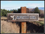
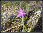
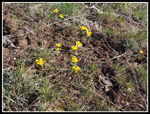
The Westberg trail does not bother with switchbacks. The ridge is fairly wide and the track goes pretty much straight up. Mostly a steady grade with several short very steep sections. The trailhead is at 1876'. The Westberg Memorial site on the ridge top is at 3568' after about 2.25 miles of hiking. We were on the lookout for any early wildflowers. Grass widows were the first. First one then several more clumps. There is sagebrush along most of the route. Just a few green leaves starting to open up. That will change dramatically in a week or two. Soon we began to see the early birds who were already coming down. Speaking of birds, there were a lot of bird calls going on much of the day.
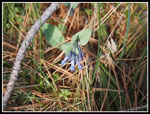
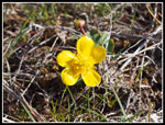
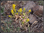
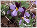
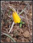
Buttercups appeared in numerous small patches. They were probably the most prolific wildflowers of the day. Janet wondered if we would see any yellow bells and a few minutes later there they were. We even saw a few bluebells on the hike to the Memorial. I found my new Olympus E-PM2 did a fine job on manual focus. I had less blurry close up flower shots than with my point and shoot. Also helping was the lack of wind. The forecast was for 5-15 mph and on the ridge it is often worse. We had very little wind all day long. With the sunshine and lack of wind we were quickly down to short sleeves. Janet went to zip off shorts by 9:00 am.
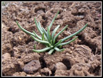
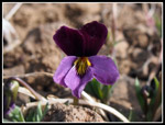
As we neared the top of Manastash Ridge the route turned right and began a more gentle ascent. We topped out at the memorial site at about 10:20 am. With the photo stops it took us 1.5 hours to hike up 2.25 miles. Not a very fast pace. This was more of a take photos and enjoy the views type of hike. There were quite a few folks at the memorial. We took a few photos then headed south to meet a road. This was a good spot for a food and water break. It's about another 2.75 miles to the UW Observatory site. It is all by road. We started down the road as it descended. More wildflowers along here. some violets and more of the flowers seen earlier. We also noticed a lot of bitterroot plants. Not close to blooming but it will be a very colorful display when they do. We also saw many dried balsamroot leaves from last year. this years plants are just coming up. There will be a lot of balsamroot when they bloom.
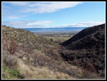
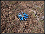
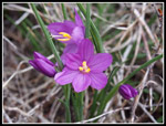
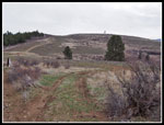
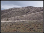
The road soon splits. We took the left fork that stays high. Just before the turn Janet noticed a rare flower. Shell flower, aka "floribunda kablamblam". A rare sighting indeed. The bright blue flowers seem to bloom all year round. I have a photo below. By now the blue sky to the south was becoming white. To the north the wind farms were periodically nearly disappearing in rain squalls. We were losing the sunshine but it we were on an island of dryness. The road had several ups and downs as we continued on. Down low there were evergreen trees in the wetter draws but few on the ridges. We now had more trees on the north side of the ridge top. The south is mostly bare except for sagebrush.
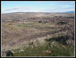
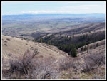
We stopped at the highpoint of our day. We were 4.03 miles from the car per my gps at an elevation of 3847'. The observatory was in sight for the first time. Still about a mile away. With the weather turning we chose to have lunch and then head back. On the hike back to the memorial site we saw one mountain bike rider and one hiker. For all the crowds the first 2.25 miles it was lonesome after that. Below us to the south was the road from Umptanum Road from Ellensburg to the Wenas Valley. The north side of Umtanum Ridge looked to be about snow free. There was one small patch of snow on the north side of Manastash below the road and that was it.
We arrived back at the Westberg Memorial at 12:37 pm. We had a few raindrops near the end of the road but that was all. We were going to sit west of the other hikers. I noticed a hiker with a black and a yellow dog. I wonder if that's John Porter? I went over to see and sure enough it was. I have run into John several times on the trail now. John has a hiking/climbing site as well called One Hike A Week though we seems to be getting out far more often now. We talked for about 30 minutes and then it was time to head down. Much less time taking photos led to a quicker time. By 2:15 pm we were back at the car. There were still 20 cars in the lot.
Drizzle began a few minutes into the drive home. It soon became light rain. By the time we reached I-90 it was steady rain. It continued most all the way home. I always enjoy getting in a dry hike on a day when it rained all day at home. This was a prime example. Their were not a lot of wildflowers out yet. We did have a good sampling of early flowers. In two to four weeks the route should be a riot of color. With the easy access both driving and hiking I may have to go back again this year. Janet and I had a great time. Always nice to get in a brand new trail.
Click on thumbnails to get
larger pictures.
Trips - 2014
Home
I was very surprised to see we were the 23rd car in the lot. It was only 8:50 am when we started out so this is one popular trailhead. Mostly blue sky overhead though it was cloudy to the north. The ridge route was clearly visible near the end of our drive. We started out on the old road and soon took a switchback right that led to the top of the ridge. Coming down we followed the ridge all the way to the bottom. The right turn just after crossing the now dry drainage creek bed was easy to miss.
The Westberg trail does not bother with switchbacks. The ridge is fairly wide and the track goes pretty much straight up. Mostly a steady grade with several short very steep sections. The trailhead is at 1876'. The Westberg Memorial site on the ridge top is at 3568' after about 2.25 miles of hiking. We were on the lookout for any early wildflowers. Grass widows were the first. First one then several more clumps. There is sagebrush along most of the route. Just a few green leaves starting to open up. That will change dramatically in a week or two. Soon we began to see the early birds who were already coming down. Speaking of birds, there were a lot of bird calls going on much of the day.
Buttercups appeared in numerous small patches. They were probably the most prolific wildflowers of the day. Janet wondered if we would see any yellow bells and a few minutes later there they were. We even saw a few bluebells on the hike to the Memorial. I found my new Olympus E-PM2 did a fine job on manual focus. I had less blurry close up flower shots than with my point and shoot. Also helping was the lack of wind. The forecast was for 5-15 mph and on the ridge it is often worse. We had very little wind all day long. With the sunshine and lack of wind we were quickly down to short sleeves. Janet went to zip off shorts by 9:00 am.
As we neared the top of Manastash Ridge the route turned right and began a more gentle ascent. We topped out at the memorial site at about 10:20 am. With the photo stops it took us 1.5 hours to hike up 2.25 miles. Not a very fast pace. This was more of a take photos and enjoy the views type of hike. There were quite a few folks at the memorial. We took a few photos then headed south to meet a road. This was a good spot for a food and water break. It's about another 2.75 miles to the UW Observatory site. It is all by road. We started down the road as it descended. More wildflowers along here. some violets and more of the flowers seen earlier. We also noticed a lot of bitterroot plants. Not close to blooming but it will be a very colorful display when they do. We also saw many dried balsamroot leaves from last year. this years plants are just coming up. There will be a lot of balsamroot when they bloom.
The road soon splits. We took the left fork that stays high. Just before the turn Janet noticed a rare flower. Shell flower, aka "floribunda kablamblam". A rare sighting indeed. The bright blue flowers seem to bloom all year round. I have a photo below. By now the blue sky to the south was becoming white. To the north the wind farms were periodically nearly disappearing in rain squalls. We were losing the sunshine but it we were on an island of dryness. The road had several ups and downs as we continued on. Down low there were evergreen trees in the wetter draws but few on the ridges. We now had more trees on the north side of the ridge top. The south is mostly bare except for sagebrush.
We stopped at the highpoint of our day. We were 4.03 miles from the car per my gps at an elevation of 3847'. The observatory was in sight for the first time. Still about a mile away. With the weather turning we chose to have lunch and then head back. On the hike back to the memorial site we saw one mountain bike rider and one hiker. For all the crowds the first 2.25 miles it was lonesome after that. Below us to the south was the road from Umptanum Road from Ellensburg to the Wenas Valley. The north side of Umtanum Ridge looked to be about snow free. There was one small patch of snow on the north side of Manastash below the road and that was it.
We arrived back at the Westberg Memorial at 12:37 pm. We had a few raindrops near the end of the road but that was all. We were going to sit west of the other hikers. I noticed a hiker with a black and a yellow dog. I wonder if that's John Porter? I went over to see and sure enough it was. I have run into John several times on the trail now. John has a hiking/climbing site as well called One Hike A Week though we seems to be getting out far more often now. We talked for about 30 minutes and then it was time to head down. Much less time taking photos led to a quicker time. By 2:15 pm we were back at the car. There were still 20 cars in the lot.
Drizzle began a few minutes into the drive home. It soon became light rain. By the time we reached I-90 it was steady rain. It continued most all the way home. I always enjoy getting in a dry hike on a day when it rained all day at home. This was a prime example. Their were not a lot of wildflowers out yet. We did have a good sampling of early flowers. In two to four weeks the route should be a riot of color. With the easy access both driving and hiking I may have to go back again this year. Janet and I had a great time. Always nice to get in a brand new trail.
 Parking Lot |
 Westberg Trail |
 Leaving Valley |
 Looking Back |
 Manastash Ridge Ahead |
 Grass Widow |
 Bluebells |
 Buttercup |
 Patch Of Buttercups |
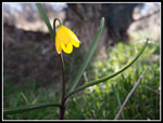 Yellow Bell |
 Memorial Site Above |
 Forest In The Draw |
 Wind Farm |
 Bitterroot |
 Violet |
 Shell Flower |
 Yellow Flower |
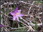 Another Grass Widow |
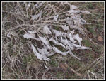 Old Balsamroot |
 More Grass Widows |
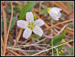 Spring Beauty |
 Nearing High Point |
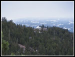 Observatory |
 Heading Back |
 Violets |
 Another Yellow Bell |
 Anthill |
 Memorial Point Ahead |
 Rain In The Valley |
 Yellow Grass |
Trips - 2014
Home