11-16-14
My
first hike up Sulphur Mountain was in 2007.
The Suiattle River Road washed out 2 miles from the end in 2003. In
2006 it washed out 11.5 miles from the end. The next year Kim and I
bikepacked to the end of the road and camped. The next day we hiked up
and down 4700' then biked back out. In 2013
we did it again. This time we would be driving to the end of the road.
That left "only" a 10 mile hike with those 4700' of elevation gain. In
the few weeks since the road has been reopened I have hiked on the
Suiattle River Trail and up to Green Mountain. Kim wanted to return to
Sulphur Mountain and I signed on. The days are getting very short so we
met in North Seattle at 5:00 am. We picked up Janet and headed north
then east to Darrington. There we met Don and Lyn. We headed up the
Suiattle River Road to the 1600' end and were the first cars to arrive.
We started hiking at 8:15 am. It was a chilly 27 degrees in Seattle and less at the trailhead. Fortunately, the trail is steep enough to warm up a hiker. Nonetheless, I had on heavy gloves and a wool hat to start. On our two previous trips we found the trail to be in pretty good shape. It remained the same this time. There are some trees down. Most are easy to step over. Several require crawling under or climbing over. Probably not more than a dozen on the whole trail. Down low there are spots that go through salal and it needs some brushing. It is not a problem following the trail though. After just a few minutes on the Suiattle trail the Sulphur Mountain route starts steeply uphill. After several hundred fast feet of gain there is a short downhill to a bridge over the only creek on the entire route. This is one dry trail in the summer.
Across the creek is the largest blow down. Not huge trees but enough to cover a short segment of trail. It is near the start and would be easy for a work party to clear out next year. The trail soon starts uphill and with one short exception never lets up. Don, Lyn, and Janet took off. Kim had not been doing many hikes with significant elevation gain and we followed at a slower pace. Our pace was steady with just a short break each hour. After the low level salal forest the ground cover abates and eventually almost disappears. This is a dark forest hike. Steep hillside, narrow trail, and very little ground cover. It is different than most hikes I do. That alone makes it an interesting hike.
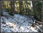
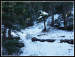
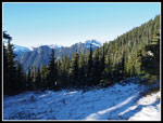
The sound of the Suiattle River is heard on much of the ascent. There was little else to hear or see. Views are non existent for the first 4000' of gain. If you hike this trail you need to make it to the top. The views up there are worth all the pain. Though we had only been on the trail two times we remembered a number of the landmarks. The upside down tree with the big rootball is still there. You hike right underneath it. After some 3000' feet of gain there is a short level stretch. A great place for a break. The climbing begins again soon. Just below 5000' we reached some snow. Just a dusting at first but soon enough to cover the trail. It was never more than 6 or 8 inches deep and generally less. It was a little slick but I did not stop to put on microspikes. The trail to Green Mountain has seen many visitors since the road reopening and that trail is well packed down and icy. Sulfur has seen visitors but not many.
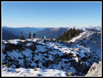
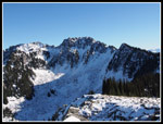
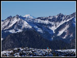
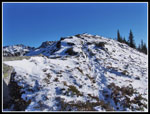
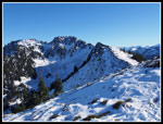
At about 5500' we broke out into meadows. Still some trees but now we had views out. There was never a cloud in the sky and the views were terrific. On our first visit there were a lot of clouds. On the second we had good views north but Glacier Peak was in and out of clouds. This day was absolutely clear. At that point I sped up and headed for the top ahead of Kim. The ridge flattens out at a big open viewpoint. A short drop and climb reaches a second bump just some 20 feet higher at just over 6200'. This one is listed as an old lookout site. There never was a permanent building there. The real summit of Sulphur Mountain is farther up the ridge and out of range for most folks in a day.
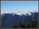
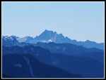
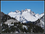
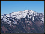
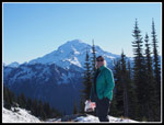
I met Lyn and Janet on top. The wind was minimal. The 39 degree temperature and sunshine made it much warmer than anywhere on the climb up in forest. Don was on the other summit and we all went over there. Dome Peak and Sinister are to the north. Sulphur Mountain is east. Glacier Peak dominates the view to the southeast. Green Mountain is west. I could see Whitechuck Mountain and even Whitehorse Mountain. A really great viewpoint. With all the peaks cloaked in a coat of fresh snow they looked great. I headed back to the other point last and Kim was already there. We had a late lunch.
I spent just over an hour on top. At 1:52 pm we headed down. We had three hours of daylight left. On last year's summer trip it took us 3:10 to descend. I figured we would need headlamps but not until the last mile. That was pretty accurate. We hiked down for 18 minutes when we ran into the only other hikes seen all day. One was Rebecca who works with Kim. It is a small world. The trail has a lot of elevation gain and loss but it is smoothly graded. No especially steep sections and few steps. It is pretty easy on the knees with so much elevation to lose. With about a mile to go Kim put on her headlamp. I held out for another half mile. It was pitch black when we neared the creek. Going around the big blowdown I lost the trail and it took a few minutes to find it again. Across the creek, uphill, then the final descent. It was 5:20 pm when we reached the car. A few minutes later the other hikers arrived.
We ended up stopping for dinner in Arlington with Rebecca and her husband. This was a fun trip. We had clear sky, great views, and near total solitude. This has never been a very popular trail though the payoff is outstanding. It is a heck of a good workout too. Best of all, we did not have an 11.5 mile bike ride with overnight backpacks at the end. A very cold day but an great late fall day to get up high in the mountains.
Click on thumbnails to get
larger pictures.
Trips - 2014
Home
We started hiking at 8:15 am. It was a chilly 27 degrees in Seattle and less at the trailhead. Fortunately, the trail is steep enough to warm up a hiker. Nonetheless, I had on heavy gloves and a wool hat to start. On our two previous trips we found the trail to be in pretty good shape. It remained the same this time. There are some trees down. Most are easy to step over. Several require crawling under or climbing over. Probably not more than a dozen on the whole trail. Down low there are spots that go through salal and it needs some brushing. It is not a problem following the trail though. After just a few minutes on the Suiattle trail the Sulphur Mountain route starts steeply uphill. After several hundred fast feet of gain there is a short downhill to a bridge over the only creek on the entire route. This is one dry trail in the summer.
Across the creek is the largest blow down. Not huge trees but enough to cover a short segment of trail. It is near the start and would be easy for a work party to clear out next year. The trail soon starts uphill and with one short exception never lets up. Don, Lyn, and Janet took off. Kim had not been doing many hikes with significant elevation gain and we followed at a slower pace. Our pace was steady with just a short break each hour. After the low level salal forest the ground cover abates and eventually almost disappears. This is a dark forest hike. Steep hillside, narrow trail, and very little ground cover. It is different than most hikes I do. That alone makes it an interesting hike.
The sound of the Suiattle River is heard on much of the ascent. There was little else to hear or see. Views are non existent for the first 4000' of gain. If you hike this trail you need to make it to the top. The views up there are worth all the pain. Though we had only been on the trail two times we remembered a number of the landmarks. The upside down tree with the big rootball is still there. You hike right underneath it. After some 3000' feet of gain there is a short level stretch. A great place for a break. The climbing begins again soon. Just below 5000' we reached some snow. Just a dusting at first but soon enough to cover the trail. It was never more than 6 or 8 inches deep and generally less. It was a little slick but I did not stop to put on microspikes. The trail to Green Mountain has seen many visitors since the road reopening and that trail is well packed down and icy. Sulfur has seen visitors but not many.
At about 5500' we broke out into meadows. Still some trees but now we had views out. There was never a cloud in the sky and the views were terrific. On our first visit there were a lot of clouds. On the second we had good views north but Glacier Peak was in and out of clouds. This day was absolutely clear. At that point I sped up and headed for the top ahead of Kim. The ridge flattens out at a big open viewpoint. A short drop and climb reaches a second bump just some 20 feet higher at just over 6200'. This one is listed as an old lookout site. There never was a permanent building there. The real summit of Sulphur Mountain is farther up the ridge and out of range for most folks in a day.
I met Lyn and Janet on top. The wind was minimal. The 39 degree temperature and sunshine made it much warmer than anywhere on the climb up in forest. Don was on the other summit and we all went over there. Dome Peak and Sinister are to the north. Sulphur Mountain is east. Glacier Peak dominates the view to the southeast. Green Mountain is west. I could see Whitechuck Mountain and even Whitehorse Mountain. A really great viewpoint. With all the peaks cloaked in a coat of fresh snow they looked great. I headed back to the other point last and Kim was already there. We had a late lunch.
I spent just over an hour on top. At 1:52 pm we headed down. We had three hours of daylight left. On last year's summer trip it took us 3:10 to descend. I figured we would need headlamps but not until the last mile. That was pretty accurate. We hiked down for 18 minutes when we ran into the only other hikes seen all day. One was Rebecca who works with Kim. It is a small world. The trail has a lot of elevation gain and loss but it is smoothly graded. No especially steep sections and few steps. It is pretty easy on the knees with so much elevation to lose. With about a mile to go Kim put on her headlamp. I held out for another half mile. It was pitch black when we neared the creek. Going around the big blowdown I lost the trail and it took a few minutes to find it again. Across the creek, uphill, then the final descent. It was 5:20 pm when we reached the car. A few minutes later the other hikers arrived.
We ended up stopping for dinner in Arlington with Rebecca and her husband. This was a fun trip. We had clear sky, great views, and near total solitude. This has never been a very popular trail though the payoff is outstanding. It is a heck of a good workout too. Best of all, we did not have an 11.5 mile bike ride with overnight backpacks at the end. A very cold day but an great late fall day to get up high in the mountains.
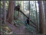 Upside Down Tree |
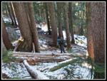 A Little Snow |
 More Snow |
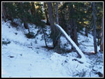 Snow Covers Trail |
 Meadows |
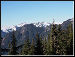 First Views |
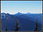 View South |
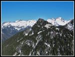
 Green Mountain |
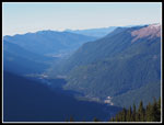 Suiattle River Valley |
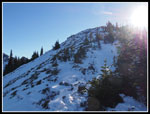 Last Slope |
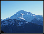 Glacier Peak |
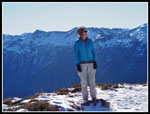 Janet On Top |
 Whitehorse Mountain |
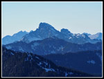 Whitechuck Mountain |
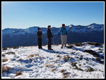 Don, Lyn, & Janet |
 Heading Back |
 Real Sulphur Summit |
 Big Peaks North |
 Dome Peak |
 Snowy Ridge |
 Mt. Baker |
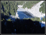 Sulphur Lake |
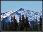 Green Mountain Again |
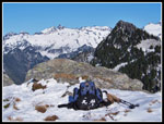 Pack & Peaks |
 Leaving Lookout Site |
 Kim & Glacier Peak |
 Lookout & Summit |
 Heading Down |
Trips - 2014
Home