5-17-15
Plans
to head east of the crest did
not pan out and so I had to plan a last minute destination. Rain and
lightening were forecast for the mountains. I decided to head to an
area long on the back burner. I have been hiking on Blanchard Hill
and Oyster Dome for a number of years. Great lower elevation hike in
the fall - spring. A nice break from Tiger Mountain in the winter. Just
north is Chuckanut Mountain. I did not find out about the change in
plans until early Sunday morning. In 75 minutes I scanned the map and
checked trip reports to find the mileage I was looking for. I found
just the trip. With my GPS and a pdf map on my phone I headed north. I
took I-5 Exit 250 just south of Bellingham. Left turn onto Old
Fairhaven Parkway for 1.3 miles and another left
onto 12th Ave
/Chuckanut Drive. 1.5 miles later I reached the
parking lot right off Chuckanut. Only half a dozen cars there at 9:10
am. Driving time of 1:23 from North Seattle.
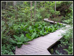
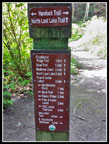
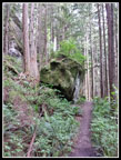
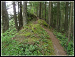
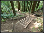
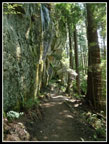
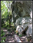
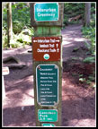
The route heads south and quickly reaches the Interurban Trail. This old passenger rail line went from Tacoma to Bellingham before my time. A section in the Kent Valley is a trail as well as a section in North King/South Snohomish County. I turned left. Most of the junctions are well signed a few are not. I missed a short cut and reached a main junction. I headed right and uphill on the Hemlock Trail. Soon came a right onto the North Lost Lake Trail and at 2.5 miles I reached a junction with the Chuckanut Ridge Trail. This was the point where my loop began and ended. The ridge trail is often right on the ridge top. A sometimes narrow ridge top. There are several breaks in the trees providing views to the left (east). I saw no views to the west. At one point I could make out the saltwater of Chuckanut Bay. It is not far away. For the most part it is just dense forest.
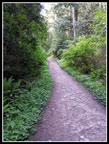
I'm told there are great views of Mt. Baker from the ridge but the clouds made that impossible. Not that I was complaining. It is often cloudier and wetter up here. This day I left home in dense low clouds and arrived at the trailhead to find blue sky. It was even a little humid. As I climbed the ridge clouds came in and made it much cooler. Great for the uphill. The ridge trail is a good boot path with occasional obstacles. A few short steep sections to scramble up. None are very difficult but not "trail like" either. At the junction with the Lower Ridge Trail I met the first person of the day. He headed down the Lower Ridge Trail.
The ridge has several sharp steep drops. 50' to 100' drops then quick climbs back up. They added more elevation gain than a quick look at the map showed. The trail eventually reaches the Cleator Road right before the Cyrus Gates Overlook. I came to a larger trail traversing around the ridge top and a minimal trail staying on the ridge. I thought this was the route down to the road near the overlook. No it wasn't. It switched back and I was pretty sure it was a trail not on the maps. Yes it was. I turned around and started back uphill when I met a lone hiker. He confirmed my error and headed back uphill with me. We reached the ridge top and continued up it. The route did bring us to Cleator Road. My companion had been out since 6:00 am and now headed down the road towards Fragrance Lake, his next objective.
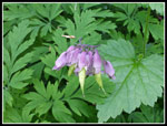
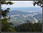
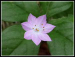
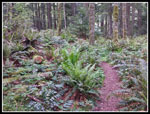
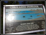
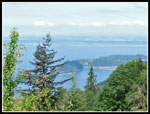
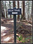
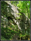
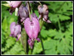
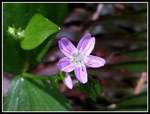
Just a few minutes later I reached the overlook. There were 8 or 9 nine cars in the lot. It was 11:45 am and time for lunch. I took 2.5 hours to hike the 5.5 miles to the overlook. There were quite a few spring wildflowers still in bloom. Buttercups, spring beauty, bleeding hears, trillium, and more. Photo stops slowed me down but were much appreciated. One of the points of my trip was to hike the newly opened Rock Trail. It starts right at the Cyrus Gates Overlook. I took a look at the view and though it was nice it is not as expansive as from Oyster Dome.
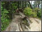
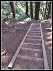
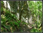
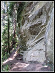
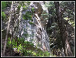
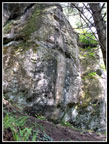
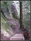
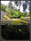
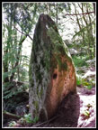
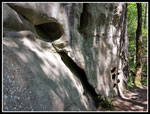
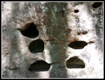
The Rock Trail is one of a kind, at least in this area. Both the trail design and the natural beauty are outstanding. After a short bit of trail I reached the first steps. The steps are very steep. The hillside is very steep. No switchbacks here, the route is more or less straight down. A very efficient way to lose elevation. After dropping the trail contours just below an amazing rock wall. Photos do not do it justice. The entire Rock Trail is only 1.2 miles and easily kept my interest. In places there are rounded holes in the rock. I would imagine that it was once below the sea level. My pace was very slow along here. Lots of see and photograph. I met two other groups on this section. Still not very crowded for a trail that starts in the city.
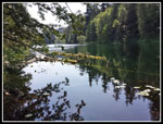
The Rock Trail dumped me out on North Lost Lake Trail. The same trail I hiked earlier in the morning. It goes right by Lost Lake though I could barely make it out below through the trees. At the next junction I turned right and went to a camping area near the end of the lake. I managed to find a spot with a view of the lake. It was a bit bigger than I was expecting. I soon headed back to the main trail. New I had a straight shot back to where my loop began. There were several junctions and all were well signed. I started to see a few more groups. The trail is right below the ridge trail I took earlier. The ridge is near vertical. Lots of green and more wildflowers along this section of trail. I took a final break at the junction with the ridge trail. I was now back on the trail I took uphill in the morning.
Coming down I passed two horse groups and finally met some mountain bikers. This is a popular place to bike but I hiked over 10 miles before I saw any. I cruised back into the parking lot at 2:45 pm. I hiked a little over 12 miles and was back plenty early. Elevation gain is hard to calculate with the ups and downs on the ridge. I'm going with about 2400' including my 150' wrong turn. Since I had never driven on Chuckanut Drive I chose the slower but more interesting route on the way home. Even with that I was home by about 4:30 pm.
All in all, I was very pleased with the hike. The ridge was a lot of fun even without the Mt. Baker views. A good assortment of wildflowers were still in bloom. The Rock Trail was great. Throw in a lake to visit and it was a fun day. Most surprising was the relative lack of crowds. Not that I'm complaining. Chuckanut Mountain is not a place I will visit on sunny summer days but off season it is a great place to hike and I still have some exploring to do.
Click on thumbnails to get
larger pictures.
Trips - 2015
Home
The route heads south and quickly reaches the Interurban Trail. This old passenger rail line went from Tacoma to Bellingham before my time. A section in the Kent Valley is a trail as well as a section in North King/South Snohomish County. I turned left. Most of the junctions are well signed a few are not. I missed a short cut and reached a main junction. I headed right and uphill on the Hemlock Trail. Soon came a right onto the North Lost Lake Trail and at 2.5 miles I reached a junction with the Chuckanut Ridge Trail. This was the point where my loop began and ended. The ridge trail is often right on the ridge top. A sometimes narrow ridge top. There are several breaks in the trees providing views to the left (east). I saw no views to the west. At one point I could make out the saltwater of Chuckanut Bay. It is not far away. For the most part it is just dense forest.
I'm told there are great views of Mt. Baker from the ridge but the clouds made that impossible. Not that I was complaining. It is often cloudier and wetter up here. This day I left home in dense low clouds and arrived at the trailhead to find blue sky. It was even a little humid. As I climbed the ridge clouds came in and made it much cooler. Great for the uphill. The ridge trail is a good boot path with occasional obstacles. A few short steep sections to scramble up. None are very difficult but not "trail like" either. At the junction with the Lower Ridge Trail I met the first person of the day. He headed down the Lower Ridge Trail.
The ridge has several sharp steep drops. 50' to 100' drops then quick climbs back up. They added more elevation gain than a quick look at the map showed. The trail eventually reaches the Cleator Road right before the Cyrus Gates Overlook. I came to a larger trail traversing around the ridge top and a minimal trail staying on the ridge. I thought this was the route down to the road near the overlook. No it wasn't. It switched back and I was pretty sure it was a trail not on the maps. Yes it was. I turned around and started back uphill when I met a lone hiker. He confirmed my error and headed back uphill with me. We reached the ridge top and continued up it. The route did bring us to Cleator Road. My companion had been out since 6:00 am and now headed down the road towards Fragrance Lake, his next objective.
Just a few minutes later I reached the overlook. There were 8 or 9 nine cars in the lot. It was 11:45 am and time for lunch. I took 2.5 hours to hike the 5.5 miles to the overlook. There were quite a few spring wildflowers still in bloom. Buttercups, spring beauty, bleeding hears, trillium, and more. Photo stops slowed me down but were much appreciated. One of the points of my trip was to hike the newly opened Rock Trail. It starts right at the Cyrus Gates Overlook. I took a look at the view and though it was nice it is not as expansive as from Oyster Dome.
The Rock Trail is one of a kind, at least in this area. Both the trail design and the natural beauty are outstanding. After a short bit of trail I reached the first steps. The steps are very steep. The hillside is very steep. No switchbacks here, the route is more or less straight down. A very efficient way to lose elevation. After dropping the trail contours just below an amazing rock wall. Photos do not do it justice. The entire Rock Trail is only 1.2 miles and easily kept my interest. In places there are rounded holes in the rock. I would imagine that it was once below the sea level. My pace was very slow along here. Lots of see and photograph. I met two other groups on this section. Still not very crowded for a trail that starts in the city.
The Rock Trail dumped me out on North Lost Lake Trail. The same trail I hiked earlier in the morning. It goes right by Lost Lake though I could barely make it out below through the trees. At the next junction I turned right and went to a camping area near the end of the lake. I managed to find a spot with a view of the lake. It was a bit bigger than I was expecting. I soon headed back to the main trail. New I had a straight shot back to where my loop began. There were several junctions and all were well signed. I started to see a few more groups. The trail is right below the ridge trail I took earlier. The ridge is near vertical. Lots of green and more wildflowers along this section of trail. I took a final break at the junction with the ridge trail. I was now back on the trail I took uphill in the morning.
Coming down I passed two horse groups and finally met some mountain bikers. This is a popular place to bike but I hiked over 10 miles before I saw any. I cruised back into the parking lot at 2:45 pm. I hiked a little over 12 miles and was back plenty early. Elevation gain is hard to calculate with the ups and downs on the ridge. I'm going with about 2400' including my 150' wrong turn. Since I had never driven on Chuckanut Drive I chose the slower but more interesting route on the way home. Even with that I was home by about 4:30 pm.
All in all, I was very pleased with the hike. The ridge was a lot of fun even without the Mt. Baker views. A good assortment of wildflowers were still in bloom. The Rock Trail was great. Throw in a lake to visit and it was a fun day. Most surprising was the relative lack of crowds. Not that I'm complaining. Chuckanut Mountain is not a place I will visit on sunny summer days but off season it is a great place to hike and I still have some exploring to do.
 Boardwalk At The Start |
 Choices, Choices... |
 Heading Up |
 Herb Robert |
 Seeding Bleeding |
 Rock On Ridge Trail |
 View North |
 Pale Small Flower |
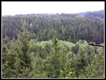 View East |
 Ridge Top Trail |
 Along The Ridge |
 Meadow On Ridge |
 Cyrus Gates Overlook |
 Overlook View |
 Rock Trail |
 Steep Steps |
 More Steps |
 Rock Wall |
 Sandstone Cliffs |
 Dappled Light |
 Neat Rock |
 Big Wall |
 Patterns |
 Even More Steps |
 Light In Darkness |
 Interesting Rock |
 "Holy" Rock |
 Shelves |
 Rock Overhang |
 Bleeding Hearts |
 Spring Beauty |
 Lost Lake |
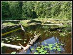 Colorful Lake |
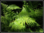 Fern Contrast |
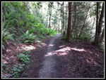 Lost Lake Trail |
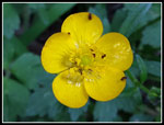 Buttercup |
 Last Junction |
Trips - 2015
Home