5-03-15
Time
for another trip to the Teanaway. This time up the MF Teanaway Road.
Gwen joined me for a repeat of a trip we did in 2012. I first hiked
this route in 1990. A lonesome fall hike where I saw one motorcyclist.
I returned for a snowshoe trip to Yellow Hill with the Mountaineers in 2003.
Janet and I did Yellow Hill on 4-30-11.
Snow from part way up the road
section to the top. Finally, Janet, Gwen, and I did the 7-1-12
trip
with just a little snow on the north side of Yellow Hill and near the
top of Elbow Peak. Two previous trips all or mostly on snow and two
mostly on dirt. Only two of them went all the way to Elbow Peak. We met
in Bellevue at 7:00 am and headed east. A stop in Cle Elum then up
Highway 970 to the NF Teanaway Road. About 7+ miles down the road we
turned left onto the WF Teanaway Road then quickly right onto the MF
Teanaway Road. A few mils after the end of pavement we crossed the
river and shortly turned into the small signed parking area at 2775'.
We arrived at 8:10 am to find two cars and some turkey hunters who were
just about to leave. It was sunny and cool.
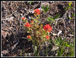
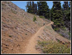
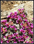
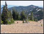
We hit the trail/road at 9:01 am. The first couple miles are on an old closed logging road. Wildflowers began immediately. We were early for the best flower show up higher but there were plenty in bloom down low and some up high. We saw arnica, Indian paintbrush, lupine, serviceberry, desert parsley, balsamroot, and more along the road. With a number of stops for photos we reached the road end at 9:48 am. I took a break to zip off my pants legs and switch to short sleeves. It was never hot but it was very comfortable for the rest of the day. From the road end to the ridge top the route is much steeper. Motorcycles have loosened a lot of small rocks making it a little hard on the feet. These slopes will be blue with lupine in a week or two. For now there some lupine in bloom but not a lot.
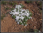
We took a break at the ridge top. A quick survey turned up some Tweedy's lewisia but the flowers have not yet opened. Another week or two here also. There as a lot of colorful phlox in bloom. With the steep part behind us the trail now follows near the ridge top. There are several ups and downs along the ridge. We had occasional views out to Earl, Navaho, Three Brothers, and Miller Peaks to the north. trail reaches the only running water we saw on the entire trip. It was running down the trail but we rerouted it across and dried up a section of trail. The next motorcycle may well wreck the repair but it will withstand boots for now.
Right after the creek is a big hillside of vanilla leaf. Last time it was all in bloom. We were a little early. There was a lot of trillium in bloom. The ridge makes a ninety degree right turn and goes up fast. The trail goes up very steeply once again. Where the trail flattens we took another break. There are logs down here and folks have been beating a path around it. I cut off a number of limbs and it is now easy to step across the logs.
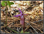
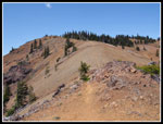
The trail enters a short section of largely dead trees. A number have fallen on the trail and been cut out. Many more look like they are about to fall over. Now came the climb to near the summit of Yellow Hill. This part is on the east side of Yellow Hill and I expected some snow. This is where we found some snow in early July 2012. The conditions in early May were almost exactly the same. Gwen noticed a number of small flowers blooming along here. We saw half a dozen patches of rare steers head from here to Elbow Peak. We saw spring beauty all along the trail. Lots of yellow bells too. As we reached the point just under the top of Yellow Hill we found snow. Up to several feet deep in places with bare ground between the snow patches. This continued until we reached the north ridge. We meet two guys coming back from Elbow Peak. They camped and started before we left Bellevue.
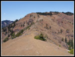
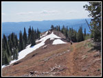
One more stop at the point the trail descends down the north ridge. Time for sunscreen, food, and water. We had a good view across the ridge to Elbow Peak plus many more summits. The view is surpassed only by the one from the top of Elbow Peak. We quickly lost several hundred feet down the ridge. The first part is in forest. We soon met the hiker with the other car. All parties were now accounted for. He too, went to Elbow Peak. In places on the ridge section there is snow on the east side. There were boot depressions in the snow and we had no trouble crossing it. It will all be gone in a few weeks. More ups and downs on the ridge until we reached the end of forest. Now comes the rock section.
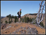
On my first visit 25 years ago I scrambled across the top. There was no trail. In 2012 there was a rocky route laid into the rock and soft dirt slope below the ridge. Cycles were clearly getting across. We used that route. This time Gwen wanted to scramble the top of the ridge. It went well and saved another drop and climb back up. There is quite a drop off the side of the ridge top. Not everyone will feel comfortable scrambling across the op of the cycle route. As scrambles go it is not difficult. It is also not a real trail. Once across we just had the last steep path leading straight up the ridge. Thankfully it was sunny but not hot. There were some more interesting and tiny flowers here. A number have yet to bloom. The top of the ridge is Elbow Peak. It's hard to tell where the high point actually is.
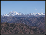
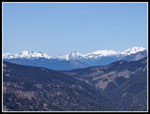
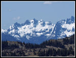
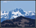
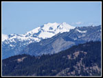
The view from Elbow are outstanding. From Rainier to Lake Cle Elum, to Domerie and Baldy, to Lemah, Summit Chief, Bears Breast, Hinman, and Daniel to the Teanaway Peaks. Mt. Stuart is the big area peak. There are no nearby much taller peaks to block the view. It is a really great spot. There was some snow in places but most of the ridge/summit is already bare. We arrived at 2:00 pm and stayed for a full hour. With all our photos and flower identification we took five hours to hike six miles. It was 3:00 pm when we packed up to head back. Two women arrived as we were leaving. Those three groups are the only people we saw all day. Yet another hike with a whole lot of solitude.
We made better time coming down though we had a lot more photo stops. We left the trail at one point to go explore a meadow. We were in no great hurry to get back to the car. The lighting was much better for some photos. A number of wildflowers were now shaded instead of being out in the sunshine. Those uphills along the ridge were not really appreciated after nine miles. We arrived back at the car at 7:10 pm. A long but enjoyable day. A quick dinner in Cle Elum and he headed for home.
This was my fifth time on this trail. The lack of snow at the start of May was remarkable. No more than on the early July trip in 2012. Yellow Hill is forested and has minimal views. Elbow Peak has tremendous views. It is well worth the extra effort. Getting there is no easy hike. There is a section of road, steep rocky trail, some deeply eroded sections. The ridge before Elbow is a bit of a scramble. Motorcycles use this trail. The payoff though are some great wildflowers and terrific views. The crowds are generally minimal too. The weather sure cooperated this day. All in all, it was a great day on the trail.
Click on thumbnails to get
larger pictures.
Trips - 2015
Home
We hit the trail/road at 9:01 am. The first couple miles are on an old closed logging road. Wildflowers began immediately. We were early for the best flower show up higher but there were plenty in bloom down low and some up high. We saw arnica, Indian paintbrush, lupine, serviceberry, desert parsley, balsamroot, and more along the road. With a number of stops for photos we reached the road end at 9:48 am. I took a break to zip off my pants legs and switch to short sleeves. It was never hot but it was very comfortable for the rest of the day. From the road end to the ridge top the route is much steeper. Motorcycles have loosened a lot of small rocks making it a little hard on the feet. These slopes will be blue with lupine in a week or two. For now there some lupine in bloom but not a lot.
We took a break at the ridge top. A quick survey turned up some Tweedy's lewisia but the flowers have not yet opened. Another week or two here also. There as a lot of colorful phlox in bloom. With the steep part behind us the trail now follows near the ridge top. There are several ups and downs along the ridge. We had occasional views out to Earl, Navaho, Three Brothers, and Miller Peaks to the north. trail reaches the only running water we saw on the entire trip. It was running down the trail but we rerouted it across and dried up a section of trail. The next motorcycle may well wreck the repair but it will withstand boots for now.
Right after the creek is a big hillside of vanilla leaf. Last time it was all in bloom. We were a little early. There was a lot of trillium in bloom. The ridge makes a ninety degree right turn and goes up fast. The trail goes up very steeply once again. Where the trail flattens we took another break. There are logs down here and folks have been beating a path around it. I cut off a number of limbs and it is now easy to step across the logs.
The trail enters a short section of largely dead trees. A number have fallen on the trail and been cut out. Many more look like they are about to fall over. Now came the climb to near the summit of Yellow Hill. This part is on the east side of Yellow Hill and I expected some snow. This is where we found some snow in early July 2012. The conditions in early May were almost exactly the same. Gwen noticed a number of small flowers blooming along here. We saw half a dozen patches of rare steers head from here to Elbow Peak. We saw spring beauty all along the trail. Lots of yellow bells too. As we reached the point just under the top of Yellow Hill we found snow. Up to several feet deep in places with bare ground between the snow patches. This continued until we reached the north ridge. We meet two guys coming back from Elbow Peak. They camped and started before we left Bellevue.
One more stop at the point the trail descends down the north ridge. Time for sunscreen, food, and water. We had a good view across the ridge to Elbow Peak plus many more summits. The view is surpassed only by the one from the top of Elbow Peak. We quickly lost several hundred feet down the ridge. The first part is in forest. We soon met the hiker with the other car. All parties were now accounted for. He too, went to Elbow Peak. In places on the ridge section there is snow on the east side. There were boot depressions in the snow and we had no trouble crossing it. It will all be gone in a few weeks. More ups and downs on the ridge until we reached the end of forest. Now comes the rock section.
On my first visit 25 years ago I scrambled across the top. There was no trail. In 2012 there was a rocky route laid into the rock and soft dirt slope below the ridge. Cycles were clearly getting across. We used that route. This time Gwen wanted to scramble the top of the ridge. It went well and saved another drop and climb back up. There is quite a drop off the side of the ridge top. Not everyone will feel comfortable scrambling across the op of the cycle route. As scrambles go it is not difficult. It is also not a real trail. Once across we just had the last steep path leading straight up the ridge. Thankfully it was sunny but not hot. There were some more interesting and tiny flowers here. A number have yet to bloom. The top of the ridge is Elbow Peak. It's hard to tell where the high point actually is.
The view from Elbow are outstanding. From Rainier to Lake Cle Elum, to Domerie and Baldy, to Lemah, Summit Chief, Bears Breast, Hinman, and Daniel to the Teanaway Peaks. Mt. Stuart is the big area peak. There are no nearby much taller peaks to block the view. It is a really great spot. There was some snow in places but most of the ridge/summit is already bare. We arrived at 2:00 pm and stayed for a full hour. With all our photos and flower identification we took five hours to hike six miles. It was 3:00 pm when we packed up to head back. Two women arrived as we were leaving. Those three groups are the only people we saw all day. Yet another hike with a whole lot of solitude.
We made better time coming down though we had a lot more photo stops. We left the trail at one point to go explore a meadow. We were in no great hurry to get back to the car. The lighting was much better for some photos. A number of wildflowers were now shaded instead of being out in the sunshine. Those uphills along the ridge were not really appreciated after nine miles. We arrived back at the car at 7:10 pm. A long but enjoyable day. A quick dinner in Cle Elum and he headed for home.
This was my fifth time on this trail. The lack of snow at the start of May was remarkable. No more than on the early July trip in 2012. Yellow Hill is forested and has minimal views. Elbow Peak has tremendous views. It is well worth the extra effort. Getting there is no easy hike. There is a section of road, steep rocky trail, some deeply eroded sections. The ridge before Elbow is a bit of a scramble. Motorcycles use this trail. The payoff though are some great wildflowers and terrific views. The crowds are generally minimal too. The weather sure cooperated this day. All in all, it was a great day on the trail.
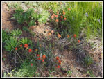 Orange Paintbrush |
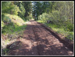 Road/Trail |
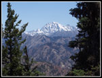
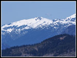
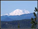 Mt. Rainier |
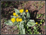 Balsamroot |
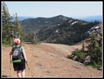
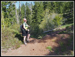 Gwen At Road End |
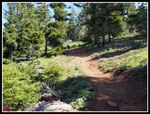 Trail To Ridge |
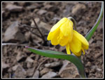
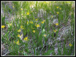 Glacier Lilies |
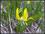 Bright Glacier Lily |
 Phlox |
 Red Indian Paintbrush |
 Calypso Orchid |
 Out Of The Forest |
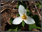 Trillium |
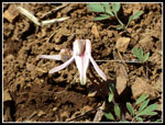 Steer's Head |
 Yellow Bells |
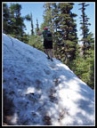 Crossing Snow Patch |
 Framed Mt. Stuart |
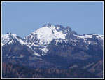
 Hawkins Mountain |
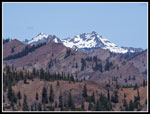
 Fortune & Ingalls Peaks |
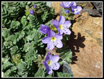 Showy Polemonium |
 Douglasia |
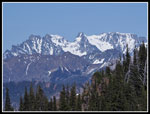
 Stuart Range |
 Gwen On Ridge |
 Open Ridge To Elbow |
 Almost Across Ridge |
 Ascending Elbow Peak |
 A Little Snow Left |
 Cascade Crest Peaks |
 Colchuck & Dragontail |
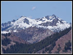 Hawkins Again |
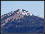 Jolly Mountain |
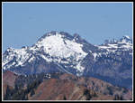 Fortune Peak |
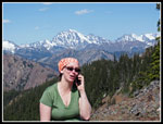 Summit Calling |
 Lemah Mountain |
 Chimney Rock & Overcoat |
 Mt. Daniel |
 Mt. Hinman |
 Bear's Breast Mt. |
 Heading Back |
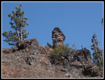 Pinnacle |
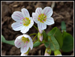 Spring Beauty |
 Tweedy's Lewisia |
 Red Currant |
 Lupine |
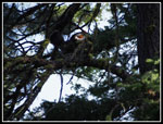 Grouse |
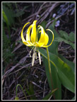 Perfect Glacier Lily |
Trips - 2015
Home