3-07-15
I
sometimes pull out the old Footsore books for hiking ideas. The books
were written about 40 years ago and not updated for at least 30. A lot
can change over that time frame. That can make it a little more of an
adventure. In June 2009 I set out to attempt
Mt. Sultan located above the town of Sultan. I left the book and my map
on my desk at home. Going my memory I just made one mistake. I turned
off on a new road some seven miles in. After retracing my steps I did
find my way to Airplane Lake just 500' below the ridge top. There did
not appear to be any road around the right side of the lake. Also I
reached hard packed snow at this point. I headed on down with a 17 mile
day and no summit or even ridge top. I planned to return. Fast forward
almost six years. A sunny early March day in a very low winter snowpack
below 5000'. Time for a return attempt.
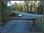
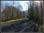
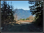
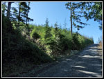
This is not a trip I would do on a summer weekend. It is not one I could convince anyone else to come along on. It is a road walk all the way. The first five miles are pretty flat. It would be easy to bike that section. I was out for a good long workout and chose to hike it once again. I headed up Highway 2 to Sultan. At the traffic light in town I turned right across the Skykomish river. At the "T" I turned right on Ben Howard Road. In about one mile I found the gated road on the left. Room for only 2-3 cars. As expected there was nobody there. I reached the 180' elevation gate at 8:30 am. The trailhead is 40' lower than my house in North Seattle.
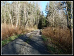
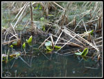
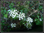
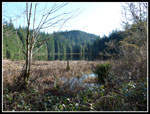
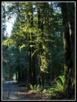
It was cool but forecast to reach near 60 in Sultan in the afternoon. Light boots and light pack for this trip. No snowshoes, no microspikes, and no ice axe. The low elevation forest is very green. Lots of moss. The way crosses McCoy Creek on a bridge. Elevation is gained at a steady rate at a very gentle grade. Easy to make good time. In 40 minutes I reached Mud Lake. There are mile markers all along the route. At the lake I found the 2 1/2 mile sign. Sixteen minute pace is fast for me. Especially with some photo stops. The sun was in my eyes looking at the lake making for some bad photos. As I left the lake I found coltsfoot and salmonberry in bloom. There were also skunk cabbage leaves opening up. Just a week after February and already signs of spring.
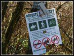
At about three miles there is a new sign. Hiking, bicycling, and horse riding are permitted. Unauthorized motorized vehicles are not. In 2009 several motorcyclists were the only people I saw all day. Now that is now longer allowed. Also, I checked the Hancock Timber Snoqualmie Tree Farm website the night before. The permitted area goes almost to the ridge top on the other side. I would be legal to go to the old lookout site and the summit of Mt. Sultan.
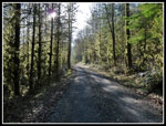
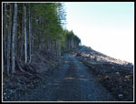
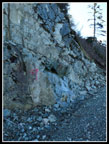
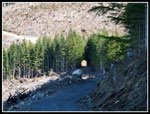
I continued to cruise along to just short of the 5 mile mark. At 900' the grade changes abruptly. I had gained only 800' (with ups and downs) in five miles. It was 10:08 am and I took a break. 1:29 to cover five miles is 18 minutes per mile. That included photos and a break at Mud Lake. Still a very fast pace for me. I had 4 miles to go to the ridge and 2700' to gain. Time to get down to business. There is a big forested bump that sits below the slope. The road climbs, switchbacks up the bump and traverses to the pass between the bump and the slope. In one place the road was blasted out of solid rock. The loggers do have ingenuity.
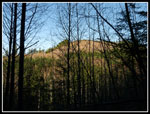
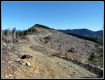
My pace slowed considerably though the fairly smooth road was not hard to climb. Views began to open up to the valley below and peaks to the north. Soon the wall of Mt. Pilchuck was in view. After a switchback I came to a place I recognized. The slope was freshly clear cut in 2009. Swaths of big trees lined creeks here. The rest of the slope was treeless. Six years later the new trees are 10+ feet high now.
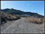
Up to this point there were several road junctions. in each case the wrong road either had grass growing on it or looked brand new. Those were easy to avoid. At about 7 miles there is a road switching back uphill. This is the one I mistakenly took in 2009. It looks just as likely as the road continuing straight. One more food and water break here. I zipped off my pants legs and switched to a short sleeve shirt. It was plenty warm while heading uphill. There was a big washout in 2006 a short way farther. It has been repaired. The road climbs to another intersection. This one goes straight ahead and down. Down is bad. turn left and uphill. Short steep switchbacks gain elevation even faster now. The next junction was brand new. Right goes down and crosses a creek. I could see a clear cut just ahead. I took the short detour.
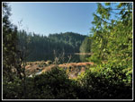
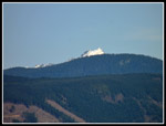
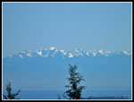
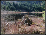
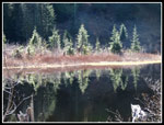
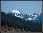
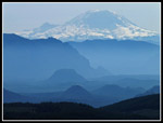
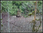
On Google Earth the night before I saw a big new clear cut just right and below Airplane Lake. A road clearly stood out going around the lake on the right and at the top of the new clear cut up to the ridge. The route of the jeep road I could not find in 2009. I was now at the bottom of that clear cut. I checked the GPS just to be sure and the main road was just 300' below the lake. I headed back to the junction for the last climb to the lake. There was forest along the road in 2009. Now it is all a clear cut. I reached the 3040' lake at 11:51 am.The boat I saw in 2009 was still there. Part of the slope above the lake has been logged. Most of it has not. One more short break and on to the ridge top. From here up I was in the shade. It was cold. The views out were excellent. in the lowlands it was hazy. Up the valley it was very clear. I could suddenly see Mt. Baker and snowy peaks to the north and northeast. There was no snow but some recent clear ice on the road.
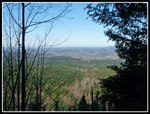
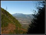
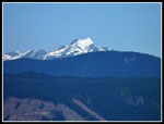
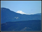
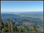
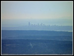
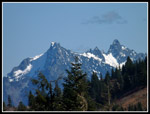
The 8 1/2 mile marker was on a rock atop a stump. The 9 mile marker was painted on a blasted rock wall. At about 9.2 miles I reached the ridge top. The other side has been recently clear cut. A short walk took me to the old lookout site. Now there are two small buildings with small towers. The views from this 3600' point are really amazing. I could look along the Cascade front and see Fuller Mountain, Little Si, Mt. Si, and Mt. Rainier rising above them all. To the right were Rattlesnake and Tiger Mountains. Downtown Bellevue and Seattle were haze but visible. The Olympics were in sight from The Brothers north.
To the north was Mt. Pilchuck now blocking Mt. Baker. In the distance I could now see the top of Glacier Peak. Haystack Ridge was the next bump and Mt. Sultan still nearly two miles away. Too far to go this day. Right of it was a snowy summit that likely is Mt. Persis. All in all a great viewpoint. If a shorter more direct trail could be built up here it would be very popular. Mt. Si views and elevation gain farther north. I arrived at 12:27 pm and stayed an hour. It was cool enough to put on a jacket. The sunshine was most welcome. I took 3:48 to hike up. At 1:26 pm I headed down.
I made much better time on the steeper first 4.2 miles. The last four miles seemed to drag on and on. I made it back to my car at 4:34 pm. My time of 3:08 coming down was 40 minutes faster than going up. I was glad to reach the lookout site after coming so close in 2009. The views were worth the effort. I also did not expect to see anybody and that proved to be true. I still want to reach the summit of Mt. Sultan. That trip will start with five miles of bike riding. A bike will bring it into the realm of a one day trip for me. Hopefully it will not take another six years.
One final word. Hancock Timber land is permitted below the ridge on the south side. My hike was completely legal per their map but descending below the ridge is not. Here is a link to download their map.
Click on thumbnails to get
larger pictures.
Trips - 2015
Home
This is not a trip I would do on a summer weekend. It is not one I could convince anyone else to come along on. It is a road walk all the way. The first five miles are pretty flat. It would be easy to bike that section. I was out for a good long workout and chose to hike it once again. I headed up Highway 2 to Sultan. At the traffic light in town I turned right across the Skykomish river. At the "T" I turned right on Ben Howard Road. In about one mile I found the gated road on the left. Room for only 2-3 cars. As expected there was nobody there. I reached the 180' elevation gate at 8:30 am. The trailhead is 40' lower than my house in North Seattle.
It was cool but forecast to reach near 60 in Sultan in the afternoon. Light boots and light pack for this trip. No snowshoes, no microspikes, and no ice axe. The low elevation forest is very green. Lots of moss. The way crosses McCoy Creek on a bridge. Elevation is gained at a steady rate at a very gentle grade. Easy to make good time. In 40 minutes I reached Mud Lake. There are mile markers all along the route. At the lake I found the 2 1/2 mile sign. Sixteen minute pace is fast for me. Especially with some photo stops. The sun was in my eyes looking at the lake making for some bad photos. As I left the lake I found coltsfoot and salmonberry in bloom. There were also skunk cabbage leaves opening up. Just a week after February and already signs of spring.
At about three miles there is a new sign. Hiking, bicycling, and horse riding are permitted. Unauthorized motorized vehicles are not. In 2009 several motorcyclists were the only people I saw all day. Now that is now longer allowed. Also, I checked the Hancock Timber Snoqualmie Tree Farm website the night before. The permitted area goes almost to the ridge top on the other side. I would be legal to go to the old lookout site and the summit of Mt. Sultan.
I continued to cruise along to just short of the 5 mile mark. At 900' the grade changes abruptly. I had gained only 800' (with ups and downs) in five miles. It was 10:08 am and I took a break. 1:29 to cover five miles is 18 minutes per mile. That included photos and a break at Mud Lake. Still a very fast pace for me. I had 4 miles to go to the ridge and 2700' to gain. Time to get down to business. There is a big forested bump that sits below the slope. The road climbs, switchbacks up the bump and traverses to the pass between the bump and the slope. In one place the road was blasted out of solid rock. The loggers do have ingenuity.
My pace slowed considerably though the fairly smooth road was not hard to climb. Views began to open up to the valley below and peaks to the north. Soon the wall of Mt. Pilchuck was in view. After a switchback I came to a place I recognized. The slope was freshly clear cut in 2009. Swaths of big trees lined creeks here. The rest of the slope was treeless. Six years later the new trees are 10+ feet high now.
Up to this point there were several road junctions. in each case the wrong road either had grass growing on it or looked brand new. Those were easy to avoid. At about 7 miles there is a road switching back uphill. This is the one I mistakenly took in 2009. It looks just as likely as the road continuing straight. One more food and water break here. I zipped off my pants legs and switched to a short sleeve shirt. It was plenty warm while heading uphill. There was a big washout in 2006 a short way farther. It has been repaired. The road climbs to another intersection. This one goes straight ahead and down. Down is bad. turn left and uphill. Short steep switchbacks gain elevation even faster now. The next junction was brand new. Right goes down and crosses a creek. I could see a clear cut just ahead. I took the short detour.
On Google Earth the night before I saw a big new clear cut just right and below Airplane Lake. A road clearly stood out going around the lake on the right and at the top of the new clear cut up to the ridge. The route of the jeep road I could not find in 2009. I was now at the bottom of that clear cut. I checked the GPS just to be sure and the main road was just 300' below the lake. I headed back to the junction for the last climb to the lake. There was forest along the road in 2009. Now it is all a clear cut. I reached the 3040' lake at 11:51 am.The boat I saw in 2009 was still there. Part of the slope above the lake has been logged. Most of it has not. One more short break and on to the ridge top. From here up I was in the shade. It was cold. The views out were excellent. in the lowlands it was hazy. Up the valley it was very clear. I could suddenly see Mt. Baker and snowy peaks to the north and northeast. There was no snow but some recent clear ice on the road.
The 8 1/2 mile marker was on a rock atop a stump. The 9 mile marker was painted on a blasted rock wall. At about 9.2 miles I reached the ridge top. The other side has been recently clear cut. A short walk took me to the old lookout site. Now there are two small buildings with small towers. The views from this 3600' point are really amazing. I could look along the Cascade front and see Fuller Mountain, Little Si, Mt. Si, and Mt. Rainier rising above them all. To the right were Rattlesnake and Tiger Mountains. Downtown Bellevue and Seattle were haze but visible. The Olympics were in sight from The Brothers north.
To the north was Mt. Pilchuck now blocking Mt. Baker. In the distance I could now see the top of Glacier Peak. Haystack Ridge was the next bump and Mt. Sultan still nearly two miles away. Too far to go this day. Right of it was a snowy summit that likely is Mt. Persis. All in all a great viewpoint. If a shorter more direct trail could be built up here it would be very popular. Mt. Si views and elevation gain farther north. I arrived at 12:27 pm and stayed an hour. It was cool enough to put on a jacket. The sunshine was most welcome. I took 3:48 to hike up. At 1:26 pm I headed down.
I made much better time on the steeper first 4.2 miles. The last four miles seemed to drag on and on. I made it back to my car at 4:34 pm. My time of 3:08 coming down was 40 minutes faster than going up. I was glad to reach the lookout site after coming so close in 2009. The views were worth the effort. I also did not expect to see anybody and that proved to be true. I still want to reach the summit of Mt. Sultan. That trip will start with five miles of bike riding. A bike will bring it into the realm of a one day trip for me. Hopefully it will not take another six years.
One final word. Hancock Timber land is permitted below the ridge on the south side. My hike was completely legal per their map but descending below the ridge is not. Here is a link to download their map.
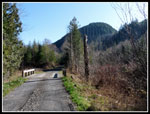
 Start Of Route |
 McCoy Creek Bridge |
 Tree Lined Road |
 Mud Lake |
 Skunk Cabbage |
 Coltsfoot |
 Hiking Is Allowed |
 Still On The Flats |
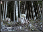
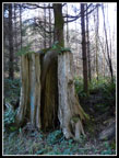 Long Roots |
 About Time To Climb |
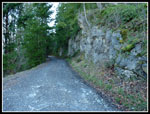 Blasted Road |
 First Views |
 Black Trees |
 Mt. Pilchuck |
 Snowy Top Of Peak |
 Into Shade |
 Reforestation |
 Three Fingers? |
 Olympic Mountains |
 Nearing Airplane Lake |
 Airplane Lake |
 Glowing Reflection |
 New Road To Ridge |
 Mt Baker |
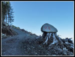
 Rock On Stump |
 8 1/2 Miles So Far |
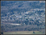 Sultan |
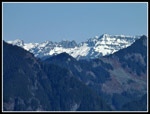 Snowy Peaks |
 9 Miles Done |
 Ridge Top At Last! |
 Old Lookout Site |
 Glacier Peak |
 Mt. Persis? |
 View Northwest |
 Downtown Seattle |
 Rainier & Mt. Si |
 Distant Peaks |
 Heading Down |
 Tree Tunnel |
 Mud Lake Again |
 Nice Lighting |
 McCoy Creek Dam |
Trips - 2015
Home