8-14-16
Gary
first did this loop trip 29
years ago. The last few years he has mentioned wanting to do it again.
Gary, John, and I had hoped to do it last year. On possible days we had
90+ degree heat. With much of this trip out in the open I was not up
for that. We did hike up to Upper Crystal Lake on a day when the smoke
drove us down immediately. It was as hard to breathe as any hike I have
ever done. Fast forward to this year and Gary suggested it again. Last
winter Gary had knee problems and stuck to very smooth and easy
descents. This summer I had tweaked my knee and have been doing smooth
trails trying to keep hiking and allow my knee to heal. I thought this
would be a stretch but worth the risk. It turned out that now John has
hurt his ACL and had to bow out of this trip. We are a sad lot at the
moment. Though it would be cooler than Saturday it would still be near
80 so we planned an early start. I was out the door at 6:00 am. I met
Gary in Kent and we headed to Enumclaw and out Highway 410. A few miles
into Mt. Rainier National Park we came to the roadside parking area.
There were already 10 cars parked at the 3550' trailhead. We packed up
and were on our way by 7:47 am.
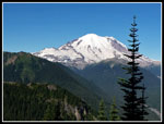
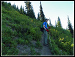
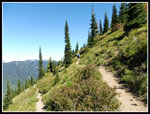
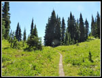
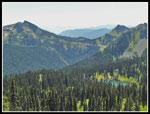
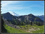
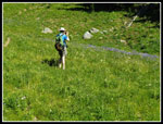
It was a little chilly at first. I was fine with shorts and short sleeves. Gary went with long pants and shirt. That changed a little later. As with most Mt. Rainier trails this one is generally smoothly graded. We climbed through dark cool forest. At one switchback there is a clear view of Mt. Rainier. The early morning light provided a great view of the mountain. At about 1.3 miles is the junction. We headed right on the trail to Crystal Peak. Many hours later we would come down via the trail to Crystal Lakes. This is where our loop began and ended. The trail crosses Crystal Creek on a bridge and mostly just contours around Crystal Peak. The traverse is 1.7 miles long. We had some wildflowers still in bloom but the peak has come and gone. That was the story for much of the hike.
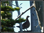
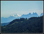
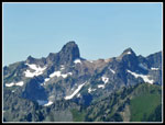
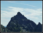
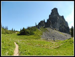
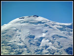
The sun was low enough still to keep a good part of the hike this far in the shade. So much the better for me. There would be many hours out in the sun this day. While we stopped for photographs a couple and a single woman passed us. They were the only folks we saw on the way up Crystal Peak. much of the traverse was in forest but we had openings with nice views out to Mt. Rainier and environs. At long last we reached the first switchback. This is the spot where we would soon be leaving the trail. For now we made another long traverse to the left and then a few short switchbacks up to the summit. Just below the top we saw a grouse which flew up into an old snag. A good spot to photograph it. The three hikers who passed us where the only folks on top. All the other cars must have had people going to Crystal Lakes. We reached the top at 10:00 am. Not great speed but we had already knocked out more than 60% of the day's elevation gain. The summit is at 6,595'. We climbed just over 3000' in 3.8 miles.
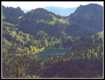
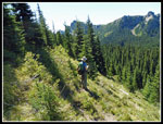
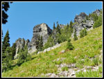
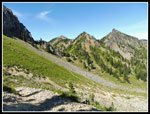
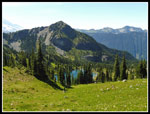
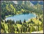
Great views from the summit. We identified Tamanos Mountain, First, Second, and Third Burroughs Mountains at Mt. Rainier. We saw Shriner Peak. Crystal Lakes set right below us. At 10:30 am we started down. We followed the ridge a ways then dropped down to the trail. Soon we were back at the switchback. Along the way we did pass several more groups heading up. There is a boot path leading away from the switchback. Had a path been beaten in during the 29 years since Gary navigated his way down to Deadwood Lakes? Not a chance. It quickly disappeared and we were left to bushwhack on a fairly steep sidehill. Not the best idea with a healing knee but I did not have any problems. We descended while making our way in the direction of the lakes. In a few places we could see one of the lakes. We made slow progress going over logs and slipping and sliding a bit.
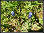
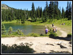
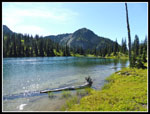
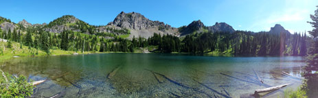
The way eventually eased and we followed an animal trail towards the first lake. We left the main trail at 11:01 am and reached the lake at 11:41 am. Not too bad for off trail travel. The lake was nicer than I was expecting. We took a partial lunch break and I put on sunscreen. We spent a half hour at the lake. It was 12:11 am when we started moving again. One of the main benefits of getting up at 5:10 am was that we now had lots of time to enjoy the hike and stop for as long as we wanted. We found a boot path going up the lake and on to the upper lake. It did not have much of an accessible shore as it was mostly marshy. Gary did notice the first blooming gentians we have seen this year. They usually signal fall so this is pretty early for them to be blooming.
For the last 10+ weeks I have seen at least one blooming tiger lily every week. When we did not see any on the open slopes of Crystal Peak I figured my steak had come to an end. Not so! A single tiger lily was blooming at Deadwood Lakes. We also saw quite a few columbine in bloom. There were a few boot prints at the lakes but not many. After the upper lake we followed the boot path as it climbed about 350' up to the ridge top. I thought the Pacific Crest Trail (PCT) was right below the ridge. Not exactly. We followed the path down, steeply in places. We lost several hundred feet and traversed back towards Chinook Pass before we met the PCT. After a very quiet morning the crowds now appeared. Sheep Lake is an easy three mile hike that is done by many families each weekend. We met folks coming out and going in. This turned out to be the hottest part of the day. Thankfully, it was much better after Sheep Lake.
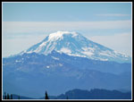
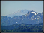
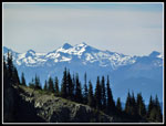
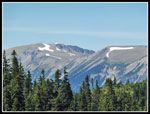
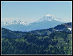
We finally reached Sheep Lake at 1:45 pm. We were 8 miles into our trip and had gained about 3900'. Now we just had a 650' climb to Sourdough Gap and it would be almost all downhill. There were the expected crowds at the lake. We had a shaded spot near the shore and took another long break. Hikers came and went. Dogs swam after sticks. A normal popular lake near a main highway. I finished off most of the rest of my lunch. We packed up and left at 2:08 pm. The PCT is generally smoothly graded. This section is no exception. The trail slowly gained elevation as it climbs to Sourdough Gap. We had great views of Mt. St. Helens, Mt. Adams, the Goat Rocks, and Mt. Hood from Crystal Peak. We had those views once again. Now we also had Sheep Lake down below.
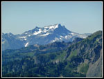
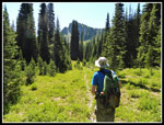
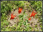
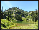
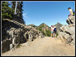
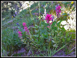
The gap is a narrow defile in the ridge. Views open up to the north from the gap. A cool breeze blew through. Very nice! Soon we were heading on. The route dropped a little and came to a junction. The PCT turned right and down. We continued ahead and climbed a little to another ridge top pass. this one looked down towards Upper Crystal Lake. The lake is not visible from the pass. Crystal Peak is right across the basin. Time for another short stop to pour rocks out of my hiking shoes. The slopes down to the lake are mostly grass with wildflowers. This would be spectacular at the peak. We had a display of lupine, red and magenta Indian paintbrush, valerian, and more. Still enough to color the hillside. This trail is narrow but it is a trail. As we descended the lake came into view. The route traverses right to avoid cliffs before turned left to reach the lake.
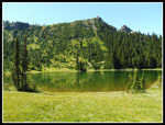
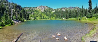
When we reached Upper Crystal Lake we saw one hiker. That was it. We went to the outlet end and took another break. We really did not want to head down. We arrived at 3:55 pm. Now we just had three downhill miles to go. We had 10.2 miles done and most all of the 4700' of elevation gain. There were some bugs at the lakes and this one was no exception. Again, they were there but not much of a problem. I swatted them a little but never went for the bug spray or felt the need for long sleeves. We stayed until 4:30 pm. Another 35 minute break. Now we had a smooth and wide trail back to the car. The lake is at 5828'. That left 2300' to descend. We kept up a steady though not fast pace. Several more groups were heading up. We reached the trailhead at 5:49. Just about exactly 10 hours after we left.
For the day we hiked 13.2 miles with 4700' of elevation gain. We had smooth trails, narrow trails, boot paths, and a cross country section. One point that was clear is that our descent from the one switchback on Crystal Peak down to Deadwood Lakes was much easier than trying to to up from the lake to find the narrow switchback. Too high or low and you would not meet the trail. Counter clockwise on the loop was the right way to go. We had one summit and three more ridge crossings plus four lakes we passed and one more we could have seen on the short trail to Lower Crystal Lake. Wildflowers were past peak but we still saw a fine show on much of the loop. If Gary and I are still hiking we may try again in another 29 years. If John wants to give it a go we may come back a little sooner. All in all, it was a very interesting day. Even better it included trails and routes I had never hiked before.
Click on thumbnails to get
larger pictures.
Trips - 2016
Home
It was a little chilly at first. I was fine with shorts and short sleeves. Gary went with long pants and shirt. That changed a little later. As with most Mt. Rainier trails this one is generally smoothly graded. We climbed through dark cool forest. At one switchback there is a clear view of Mt. Rainier. The early morning light provided a great view of the mountain. At about 1.3 miles is the junction. We headed right on the trail to Crystal Peak. Many hours later we would come down via the trail to Crystal Lakes. This is where our loop began and ended. The trail crosses Crystal Creek on a bridge and mostly just contours around Crystal Peak. The traverse is 1.7 miles long. We had some wildflowers still in bloom but the peak has come and gone. That was the story for much of the hike.
The sun was low enough still to keep a good part of the hike this far in the shade. So much the better for me. There would be many hours out in the sun this day. While we stopped for photographs a couple and a single woman passed us. They were the only folks we saw on the way up Crystal Peak. much of the traverse was in forest but we had openings with nice views out to Mt. Rainier and environs. At long last we reached the first switchback. This is the spot where we would soon be leaving the trail. For now we made another long traverse to the left and then a few short switchbacks up to the summit. Just below the top we saw a grouse which flew up into an old snag. A good spot to photograph it. The three hikers who passed us where the only folks on top. All the other cars must have had people going to Crystal Lakes. We reached the top at 10:00 am. Not great speed but we had already knocked out more than 60% of the day's elevation gain. The summit is at 6,595'. We climbed just over 3000' in 3.8 miles.
Great views from the summit. We identified Tamanos Mountain, First, Second, and Third Burroughs Mountains at Mt. Rainier. We saw Shriner Peak. Crystal Lakes set right below us. At 10:30 am we started down. We followed the ridge a ways then dropped down to the trail. Soon we were back at the switchback. Along the way we did pass several more groups heading up. There is a boot path leading away from the switchback. Had a path been beaten in during the 29 years since Gary navigated his way down to Deadwood Lakes? Not a chance. It quickly disappeared and we were left to bushwhack on a fairly steep sidehill. Not the best idea with a healing knee but I did not have any problems. We descended while making our way in the direction of the lakes. In a few places we could see one of the lakes. We made slow progress going over logs and slipping and sliding a bit.
The way eventually eased and we followed an animal trail towards the first lake. We left the main trail at 11:01 am and reached the lake at 11:41 am. Not too bad for off trail travel. The lake was nicer than I was expecting. We took a partial lunch break and I put on sunscreen. We spent a half hour at the lake. It was 12:11 am when we started moving again. One of the main benefits of getting up at 5:10 am was that we now had lots of time to enjoy the hike and stop for as long as we wanted. We found a boot path going up the lake and on to the upper lake. It did not have much of an accessible shore as it was mostly marshy. Gary did notice the first blooming gentians we have seen this year. They usually signal fall so this is pretty early for them to be blooming.
For the last 10+ weeks I have seen at least one blooming tiger lily every week. When we did not see any on the open slopes of Crystal Peak I figured my steak had come to an end. Not so! A single tiger lily was blooming at Deadwood Lakes. We also saw quite a few columbine in bloom. There were a few boot prints at the lakes but not many. After the upper lake we followed the boot path as it climbed about 350' up to the ridge top. I thought the Pacific Crest Trail (PCT) was right below the ridge. Not exactly. We followed the path down, steeply in places. We lost several hundred feet and traversed back towards Chinook Pass before we met the PCT. After a very quiet morning the crowds now appeared. Sheep Lake is an easy three mile hike that is done by many families each weekend. We met folks coming out and going in. This turned out to be the hottest part of the day. Thankfully, it was much better after Sheep Lake.
We finally reached Sheep Lake at 1:45 pm. We were 8 miles into our trip and had gained about 3900'. Now we just had a 650' climb to Sourdough Gap and it would be almost all downhill. There were the expected crowds at the lake. We had a shaded spot near the shore and took another long break. Hikers came and went. Dogs swam after sticks. A normal popular lake near a main highway. I finished off most of the rest of my lunch. We packed up and left at 2:08 pm. The PCT is generally smoothly graded. This section is no exception. The trail slowly gained elevation as it climbs to Sourdough Gap. We had great views of Mt. St. Helens, Mt. Adams, the Goat Rocks, and Mt. Hood from Crystal Peak. We had those views once again. Now we also had Sheep Lake down below.
The gap is a narrow defile in the ridge. Views open up to the north from the gap. A cool breeze blew through. Very nice! Soon we were heading on. The route dropped a little and came to a junction. The PCT turned right and down. We continued ahead and climbed a little to another ridge top pass. this one looked down towards Upper Crystal Lake. The lake is not visible from the pass. Crystal Peak is right across the basin. Time for another short stop to pour rocks out of my hiking shoes. The slopes down to the lake are mostly grass with wildflowers. This would be spectacular at the peak. We had a display of lupine, red and magenta Indian paintbrush, valerian, and more. Still enough to color the hillside. This trail is narrow but it is a trail. As we descended the lake came into view. The route traverses right to avoid cliffs before turned left to reach the lake.
When we reached Upper Crystal Lake we saw one hiker. That was it. We went to the outlet end and took another break. We really did not want to head down. We arrived at 3:55 pm. Now we just had three downhill miles to go. We had 10.2 miles done and most all of the 4700' of elevation gain. There were some bugs at the lakes and this one was no exception. Again, they were there but not much of a problem. I swatted them a little but never went for the bug spray or felt the need for long sleeves. We stayed until 4:30 pm. Another 35 minute break. Now we had a smooth and wide trail back to the car. The lake is at 5828'. That left 2300' to descend. We kept up a steady though not fast pace. Several more groups were heading up. We reached the trailhead at 5:49. Just about exactly 10 hours after we left.
For the day we hiked 13.2 miles with 4700' of elevation gain. We had smooth trails, narrow trails, boot paths, and a cross country section. One point that was clear is that our descent from the one switchback on Crystal Peak down to Deadwood Lakes was much easier than trying to to up from the lake to find the narrow switchback. Too high or low and you would not meet the trail. Counter clockwise on the loop was the right way to go. We had one summit and three more ridge crossings plus four lakes we passed and one more we could have seen on the short trail to Lower Crystal Lake. Wildflowers were past peak but we still saw a fine show on much of the loop. If Gary and I are still hiking we may try again in another 29 years. If John wants to give it a go we may come back a little sooner. All in all, it was a very interesting day. Even better it included trails and routes I had never hiked before.
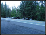 Parking Area |
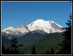 First Mt. Rainier View |
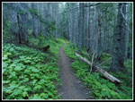 Green Ground Cover |
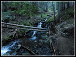 Crystal Creek |
 Mt. Rainier Again |
 Gary On Shady Trail |
 Grouse |
 Mt. Adams |
 Glacier Peak |
 Mt. St. Helens |
 Upper Crystal Lake |
 Snowy Peak |
 Cowlitz Chimneys |
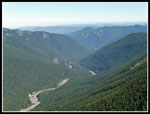 White River Valley |
 Rock Arch |
 The Goat Rocks |
 The Switchback |
 Off Trail |
 Nearing The Lake |
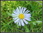 Aster |
 Columbine |
 Upper Deadwood Lake |
 Gentian |
 Burroughs Mountains |
 Ridge Top Meadow |
 Sheep Lake |
 Sheep Lake Again |
 Rock & Flowers |
 Chinook Pass |
 Sourdough Gap |
 Looking North |
 Goat Rocks & Adams |
 Sliver Of Rainier |
 Leaving Saddle |
 Crystal Lake & Peak |
 Bright Clouds |
 Mt. Rainier Summit |
 Crystal Lake & Meadow |
 Magenta Paintbrush |
 Gary & Lupine |
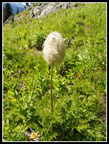 Western Anemone |
 Crystal Lake Shore |
 Lower Deadwood Lake Panorama |
 Sheep Lake Panorama |
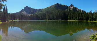
 Upper Crystal Lake Panorama |
Trips - 2016
Home