1-02-16
Last
year we had virtually no snow. I managed one snowshoe trip. Now we have
snow. Time for another. I joined Gwen, Kim, and Kevin for a trip east
of Stevens Pass. I met Kim in Seattle then we moved to Gwen's car in
Bothell. One more stop in Index to pick up Kevin and we headed over
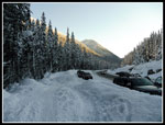
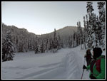
Steven's Pass. It was 16 degrees at the pass. It began to drop fast as
we descended the east side. By the parking area at Smith Brook Road it
was 2 degrees. Having grown up in Seattle that is the second coldest
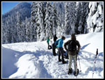
temperature I have recreated in. It was just before 9:00 am when we
started out. The usual wall of snow is along the highway. The path atop
it was hard enough to walk in just boots. That happens when it is two
degrees. I almost never start out hiking uphill with a jacket on. The
road was so firm that we headed up without wearing snowshoes. Decent
traction and we did not sink in at all. Much better conditions than I
expected.
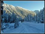
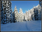
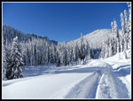
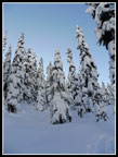
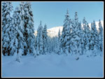
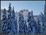
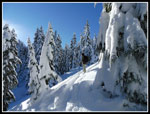
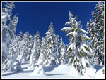
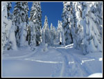
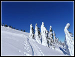
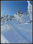
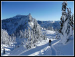
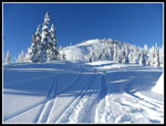
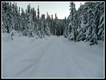
The steady stream of winter storms that blew through in December left all the trees heavily coated in snow. Smaller trees were just blobs of white. While Smith Brook Road is not so great looking, all the snow made it look as good as possible. We trudged along at a steady pace. One reason I wanted to do this trip again was that another group had put in a compacted trench all the way to the summit. Breaking trail in this much snow is a big job. I had been up McCausland three times previously. The last time was in 2011.
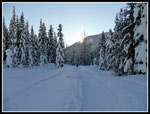
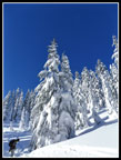
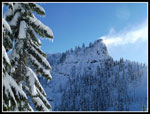
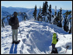
At the first switchback in the road we stopped to put on snowshoes. The track went straight uphill to cut off the switchback. While waiting David and Lyndsey showed up. they were planning to snowshoe up Lichtenberg Mountain. David was on the trip when I had my only visit to the summit of Lichtenberg. They were hunting around for the start of another recently put in snowshoe track. The off road shortcut saved us a lot of road walking. Once, back on the road we had an easy and fairly level walk to the next switchback.
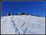
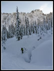
Part way along the road David and Lyndsey caught up with us again. They tried one track that did not go far and continued up the road. They took off on another deeper trench and we said goodbye. Where the road makes another big switchback we were ready to head off road. There were two tracks heading off. On the right was one heading off towards Union and Jove Peaks. To the left is the trail we took. The route dropped off the road and crossed the valley. Along the way we crossed Smith Brook on a snow bridge. Some of the creek/crevasses we crossed were 7-10 feet deep. Falling in would be a problem. On most of them I could jump across the narrow gaps atop the snow bridge. The trench was nicely set and with the low temperatures it was very firm. It was easy to make a steady pace.
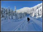
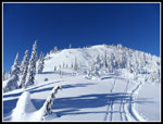
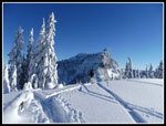
The route worked its way along the side of the valley as it climbed. At one point we met a junction. Left kept going up the hillside. Right ascended more gently. Though each of my trips to McCausland was by a different route, I recalled a meadow part way up. We had been in shade most of the way since leaving the road and a little sunny warmth sounded good. When we reached the open meadow it was all in shade. I had not visited this early in the year. The sun probably never reached the meadow. At the meadow Kim decided to go a little farther then enjoy all the snow and head back to the road. The rest of us headed on. From the meadow the gentle climbing is replaced by a steeper ascent. The route was aiming left of the summit and right of the saddle between McCausland and Lichtenberg.
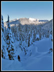
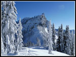
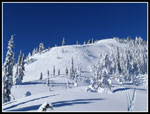
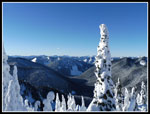
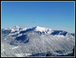
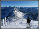
My last several visits were by ascending more gentle slopes below the summit. We were not going to break trail however when we had a nice trench ahead. Views kept getting better as we rose. Rock Mountain came into view. More peaks to the south too. Although the forecast was for winds to be around 20 mph all day, they had been nice and light so far. When we reached the ridge top there was a little more breeze. Still not a problem. The summit was now in sight. We headed right for it on the now flattish ridge. Ahead was a very steep climb along the ridge. There were slalom ski tracks coming down but no snowshoe tracks. On my first visit Gary and I went straight up that slope. It was about the steepest one I have climbed with snowshoes. The trench went below it climbing at a moderate grade. We went that way.
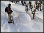
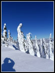
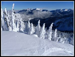
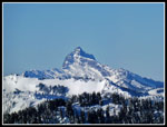
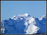
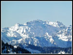
The route went almost under the summit before switching back. Two backcountry skiers passes us by here. The only people we saw off the road. Several more switchbacks and the summit was now just above. In the last 150' vertical feet the wind really began to blow. With the temperature around 10 degrees and all that wind it was brutal. Especially when taking off a glove to take photos. We dropped down into a low spot partly out of the wind for some food and water. A line of trees block views to the north. A gap was well packed down and provided a spot to see that view. Sloan, Kyes, and the Monte Cristo peaks stood out. Kevin had software that showed the profiles and names of all the peaks. Very handy. I could see a sliver of Glacier Peak. To the south we could see Rainier, Daniel, Hinman, Stuart and many more peaks.
Our stay on top was short. By 1:57 pm we were on our way down. It did not take long to drop out of the wind. Instantly it felt much warmer. Feeling began to return to my hands. We took a lot of photos on the way down. you do not get blue sky and so much snow flocking everything very often. Even so, we made much better time. At 3:40 pm we made it back to the road. Kim was there. Also there, just down from Union and Jove Peaks was Brett Dyson and his group. I did some Mountaineer scramble trips with him years back. Nice to run into old friends in the mountains. They headed down and we did shortly after. We followed our route down. One pair of skier shot by us. They were the only folks we saw. It was just fully dark as we reached the car a little after 5:00 pm.
That should have been the end of the story. It wasn't. We were on the road at 5:20 pm. Things were fine until we were a few miles short of Baring. That's where traffic came to a complete halt. Ski traffic can be bad when the day skiers head home. This was the worst Highway 2 back up I have ever been in. We inched along for hours. We had short stops to drop off Kevin and get some burgers to go entering Sultan. Leaving Sultan it finally moved at something near the speed limit. I arrived home at 10:05 pm. The trip was great. A 4 1/2 hour drive home was painful. The drive aside, this was a fantastic trip. Half the folks we saw were folks we knew. We did not see many people. Great snow, blue sky and extremely low temperatures. The views outweighed the cold. I'm sure I'll be back at some point in the future.
--------------------------------------------------------------------------------------------------------------------------------------------------------------------------------------------
-------A final note. There has not been much snow the last few winters. Do not think that this is a safe trip in all conditions. We checked the NW Avalanche Center site and were careful in assessing the conditions on route. Be very careful when being out in the mountains in winter. I have stayed home or turned around on many winter weekends.-----------
Click on thumbnails to get
larger pictures.
Trips - 2016
Home
The steady stream of winter storms that blew through in December left all the trees heavily coated in snow. Smaller trees were just blobs of white. While Smith Brook Road is not so great looking, all the snow made it look as good as possible. We trudged along at a steady pace. One reason I wanted to do this trip again was that another group had put in a compacted trench all the way to the summit. Breaking trail in this much snow is a big job. I had been up McCausland three times previously. The last time was in 2011.
At the first switchback in the road we stopped to put on snowshoes. The track went straight uphill to cut off the switchback. While waiting David and Lyndsey showed up. they were planning to snowshoe up Lichtenberg Mountain. David was on the trip when I had my only visit to the summit of Lichtenberg. They were hunting around for the start of another recently put in snowshoe track. The off road shortcut saved us a lot of road walking. Once, back on the road we had an easy and fairly level walk to the next switchback.
Part way along the road David and Lyndsey caught up with us again. They tried one track that did not go far and continued up the road. They took off on another deeper trench and we said goodbye. Where the road makes another big switchback we were ready to head off road. There were two tracks heading off. On the right was one heading off towards Union and Jove Peaks. To the left is the trail we took. The route dropped off the road and crossed the valley. Along the way we crossed Smith Brook on a snow bridge. Some of the creek/crevasses we crossed were 7-10 feet deep. Falling in would be a problem. On most of them I could jump across the narrow gaps atop the snow bridge. The trench was nicely set and with the low temperatures it was very firm. It was easy to make a steady pace.
The route worked its way along the side of the valley as it climbed. At one point we met a junction. Left kept going up the hillside. Right ascended more gently. Though each of my trips to McCausland was by a different route, I recalled a meadow part way up. We had been in shade most of the way since leaving the road and a little sunny warmth sounded good. When we reached the open meadow it was all in shade. I had not visited this early in the year. The sun probably never reached the meadow. At the meadow Kim decided to go a little farther then enjoy all the snow and head back to the road. The rest of us headed on. From the meadow the gentle climbing is replaced by a steeper ascent. The route was aiming left of the summit and right of the saddle between McCausland and Lichtenberg.
My last several visits were by ascending more gentle slopes below the summit. We were not going to break trail however when we had a nice trench ahead. Views kept getting better as we rose. Rock Mountain came into view. More peaks to the south too. Although the forecast was for winds to be around 20 mph all day, they had been nice and light so far. When we reached the ridge top there was a little more breeze. Still not a problem. The summit was now in sight. We headed right for it on the now flattish ridge. Ahead was a very steep climb along the ridge. There were slalom ski tracks coming down but no snowshoe tracks. On my first visit Gary and I went straight up that slope. It was about the steepest one I have climbed with snowshoes. The trench went below it climbing at a moderate grade. We went that way.
The route went almost under the summit before switching back. Two backcountry skiers passes us by here. The only people we saw off the road. Several more switchbacks and the summit was now just above. In the last 150' vertical feet the wind really began to blow. With the temperature around 10 degrees and all that wind it was brutal. Especially when taking off a glove to take photos. We dropped down into a low spot partly out of the wind for some food and water. A line of trees block views to the north. A gap was well packed down and provided a spot to see that view. Sloan, Kyes, and the Monte Cristo peaks stood out. Kevin had software that showed the profiles and names of all the peaks. Very handy. I could see a sliver of Glacier Peak. To the south we could see Rainier, Daniel, Hinman, Stuart and many more peaks.
Our stay on top was short. By 1:57 pm we were on our way down. It did not take long to drop out of the wind. Instantly it felt much warmer. Feeling began to return to my hands. We took a lot of photos on the way down. you do not get blue sky and so much snow flocking everything very often. Even so, we made much better time. At 3:40 pm we made it back to the road. Kim was there. Also there, just down from Union and Jove Peaks was Brett Dyson and his group. I did some Mountaineer scramble trips with him years back. Nice to run into old friends in the mountains. They headed down and we did shortly after. We followed our route down. One pair of skier shot by us. They were the only folks we saw. It was just fully dark as we reached the car a little after 5:00 pm.
That should have been the end of the story. It wasn't. We were on the road at 5:20 pm. Things were fine until we were a few miles short of Baring. That's where traffic came to a complete halt. Ski traffic can be bad when the day skiers head home. This was the worst Highway 2 back up I have ever been in. We inched along for hours. We had short stops to drop off Kevin and get some burgers to go entering Sultan. Leaving Sultan it finally moved at something near the speed limit. I arrived home at 10:05 pm. The trip was great. A 4 1/2 hour drive home was painful. The drive aside, this was a fantastic trip. Half the folks we saw were folks we knew. We did not see many people. Great snow, blue sky and extremely low temperatures. The views outweighed the cold. I'm sure I'll be back at some point in the future.
--------------------------------------------------------------------------------------------------------------------------------------------------------------------------------------------
-------A final note. There has not been much snow the last few winters. Do not think that this is a safe trip in all conditions. We checked the NW Avalanche Center site and were careful in assessing the conditions on route. Be very careful when being out in the mountains in winter. I have stayed home or turned around on many winter weekends.-----------
 Along The Highway |
 Looking East |
 Sun Shines Over Ridge |
 Sunshine Ahead |
 Snowshoes Go On |
 Beautiful! |
 Union Peak |
 Kevin & Snow Shroom |
 Heavily Laden |
 Distant Sunshine |
 Lichtenberg Mountain |
 Climbing In Shade |
 Kevin Enjoys View |
 Bright Sunshine |
 Blindingly Bright |
 Blowing Snow |
 Nearing Ridge |
 Ridge Top View |
 Summit In Sight |
 Lots Of Tracks |
 Almost There |
 Praying? |
 View East |
 Summit Above |
 Sloan Peak |
 Kyes Peak |
 Monte Cristo Peaks |
 Very Nice Views |
 Rock & Howard |
 Summit Refuge |
 Heading Down |
 Steep Section |
 Kevin Leads |
 Tracks & Peaks |
 Summit & Tracks |
 Crossing Snow Bridge |
 Back On Road |
 Road Slog |
Trips - 2016
Home