1-28-17
Janet
invited me along on a
snowshoe trip up Hex Mountain. Hex is a favorite winter snowshoe trip.
It is only about a 4 mile round trip in the summer. In the winter the
start is down at the main road along Lake Cle Elum and that makes it 8
miles with 2700'. The road walk to the summer trailhead covers half the
distance to the top. Janet and I went
up in December 2010 in the year
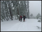
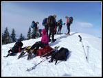
she had both knees replaced. That was an accomplishment then. We met in
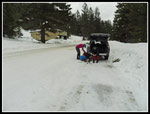
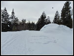
Bellevue at 7:30 am and headed east. We went through Roslyn and parked
at the plowed spot just before Newport Creek and just past the fire
station. A Mountaineers group arrived just before us and took up three
spaces. With a few other cars there were only four or so spots left. It
was 38 degrees when we got started. Not too bad after a cold start to
the year. The Mountaineers started a little ahead of us. We were on the
move by 9:30 am.
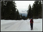
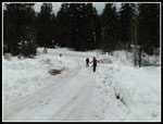
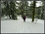
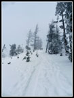
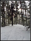
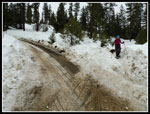
The other group went up the first road. We went on to the second road, the one that goes to the Hex Mountain summer trailhead. There is winter logging going on up the road. It has been plowed. On the one hand, we did not need snowshoes at first. On the other hand it was a bit icy. Microspikes would have been useful. I was the only person that brought them so I chose to just boot it. Up the first steep part and we met the Mountaineers who had crossed over to this road. We played leap frog with them several times. The steepest part of the road walk is down low.
Most online trip reports spent more time trying to describe the road system than the the hike. Many never found the summer trailhead. On my first visits years ago there was one main road and a few smaller spurs. Now there are multiple roads. A map is helpful though many roads are not no most maps. My phone GPS app had an old map that just snowed the main road as solid with a few dashed lines for spurs. Following that worked fine. Well almost fine. On my last two visits I the wrong road was taken and a cross country leg was needed to find the summer trail. I hoped that I would not make any mistakes this time. I came close.
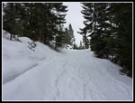
We saw a berm on the right but did not recognize a big road there. A few minutes later I checked the GPS again and we missed the turn off. Instead of going downhill to find the right road I noticed it was still running parallel to our nicely plowed road. We went a short way uphill then more steeply down to find the correct road. Now it was just a slog on to the summer trailhead. Since we put on snowshoes for the cross country part we did not bother taking them off. With the sub freezing temperature we could have booted it to the trailhead. After about two miles of road walking we reached the sign for the Hex Mountain Trail.
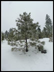
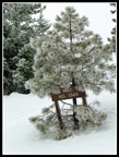
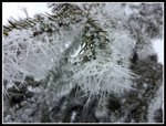
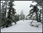
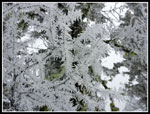
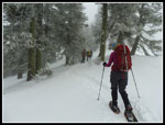
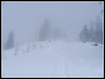
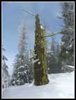
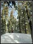
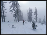
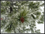
We had gained about 1000'. The next two miles of trail would gain about 1600'. The other 100' is going down and then up a drop on the ridge walk. Another couple came along as we took a break. All along the route we noticed that the trees were coated in white. It was very cloudy and gray and the trees were frosty white. That made for some neat photos. Janet noticed that some trees had sharp snow spikes that made a pine tree look like a cactus. Another neat feature. For all the gray the trip was very scenic close up. The trail was well packed down. With snowshoes traction was excellent all the way up. The route more or less goes straight up the ridge. Last year I had a rare clear day and found that there are several places where the summit is in view. Not this day. We could not even see down to the bottom of Newport Creek. It was not pea soup but it views were very limited.
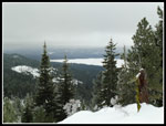
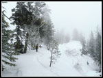
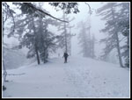
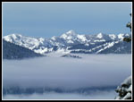
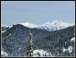
We stopped for a number of photo breaks but kept up a reasonable pace. A couple groups did pass us by. The trail is a good workout as it has some fairly steep sections. Part way up there is a newer logging landing. The flat spot makes for a good break spot. We again met a group of guys who had passed us. They were running out of time as they had be be back in town. Unfortunately, they missed the best that was soon to come. They turned back a little bit early. The open clear cut part of the ridge is usually a wind tunnel. Even when it is calm above and below it seems to blow there. Not this day. We had almost zero wind all day. That made it seem warmer than expected. Soon we were back into forest again. Through the trees I could now see peaks off to the west and northwest. Below was a thick cloud layer in the valley. Maybe we would have views from the summit!
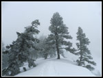
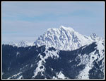
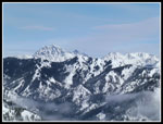
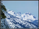
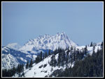
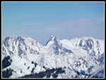
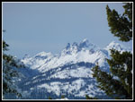
At the top of Sasse Ridge the route turned right and headed for the nearby summit. Flat at first, the ridge gets pretty steep right below the top. Traction was still great and we had no trouble topping out. On top we found the eight Mountaineers and four or so others. Quite a crowd. Below us was a sea of clouds. Above was blue sky. Mountains everywhere. Hinman, Daniel, Bears Breast, The Cradle, Jolly, Stuart and the Stuart Range, Elbow and Yellow Peak. Rainier was to the southwest. I love blue sky, white peaks, and clouds below. I had not idea at the start of the day that we would break through to a sunny day. What a treat. We arrived on top at about 1:18 pm. We stayed until almost 2:00 pm. I never even put on a jacket on the summit. It felt warm in the sunshine.
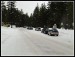
It was hard to leave. The first steep drop off the summit was a bit difficult. The rest of the way down was easy. The hard part was descending back into the gray muck. It was instantly 10 degrees colder or at least it felt like it. No detours going down as the road we descended ran into the main plowed road. That one was much barer than in the morning. A few vehicles and above freezing temperatures made for a few bare dirt spots. I did dump my snowshoes on the plowed road and put on microspikes. A lot quieter than my plastic snowshoes on icy snow. We did pass a few more groups heading up and there were still seven other cars in the parking spot. With a number of stops on the way up we took 3:35. We reached the cars at 4:13 pm It only took 2:15 to come down.
I was expecting a dark gray but dry day. We had that but also a summit in the sunshine with great views all around. Much better conditions than I ever expected. It was nice to get out with Janet and Steve again too. What a great day in the mountains.
Click on thumbnails to get
larger pictures.
Trips - 2017
Home
The other group went up the first road. We went on to the second road, the one that goes to the Hex Mountain summer trailhead. There is winter logging going on up the road. It has been plowed. On the one hand, we did not need snowshoes at first. On the other hand it was a bit icy. Microspikes would have been useful. I was the only person that brought them so I chose to just boot it. Up the first steep part and we met the Mountaineers who had crossed over to this road. We played leap frog with them several times. The steepest part of the road walk is down low.
Most online trip reports spent more time trying to describe the road system than the the hike. Many never found the summer trailhead. On my first visits years ago there was one main road and a few smaller spurs. Now there are multiple roads. A map is helpful though many roads are not no most maps. My phone GPS app had an old map that just snowed the main road as solid with a few dashed lines for spurs. Following that worked fine. Well almost fine. On my last two visits I the wrong road was taken and a cross country leg was needed to find the summer trail. I hoped that I would not make any mistakes this time. I came close.
We saw a berm on the right but did not recognize a big road there. A few minutes later I checked the GPS again and we missed the turn off. Instead of going downhill to find the right road I noticed it was still running parallel to our nicely plowed road. We went a short way uphill then more steeply down to find the correct road. Now it was just a slog on to the summer trailhead. Since we put on snowshoes for the cross country part we did not bother taking them off. With the sub freezing temperature we could have booted it to the trailhead. After about two miles of road walking we reached the sign for the Hex Mountain Trail.
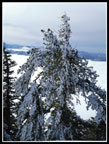
We had gained about 1000'. The next two miles of trail would gain about 1600'. The other 100' is going down and then up a drop on the ridge walk. Another couple came along as we took a break. All along the route we noticed that the trees were coated in white. It was very cloudy and gray and the trees were frosty white. That made for some neat photos. Janet noticed that some trees had sharp snow spikes that made a pine tree look like a cactus. Another neat feature. For all the gray the trip was very scenic close up. The trail was well packed down. With snowshoes traction was excellent all the way up. The route more or less goes straight up the ridge. Last year I had a rare clear day and found that there are several places where the summit is in view. Not this day. We could not even see down to the bottom of Newport Creek. It was not pea soup but it views were very limited.
We stopped for a number of photo breaks but kept up a reasonable pace. A couple groups did pass us by. The trail is a good workout as it has some fairly steep sections. Part way up there is a newer logging landing. The flat spot makes for a good break spot. We again met a group of guys who had passed us. They were running out of time as they had be be back in town. Unfortunately, they missed the best that was soon to come. They turned back a little bit early. The open clear cut part of the ridge is usually a wind tunnel. Even when it is calm above and below it seems to blow there. Not this day. We had almost zero wind all day. That made it seem warmer than expected. Soon we were back into forest again. Through the trees I could now see peaks off to the west and northwest. Below was a thick cloud layer in the valley. Maybe we would have views from the summit!
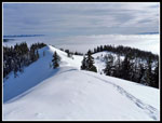
At the top of Sasse Ridge the route turned right and headed for the nearby summit. Flat at first, the ridge gets pretty steep right below the top. Traction was still great and we had no trouble topping out. On top we found the eight Mountaineers and four or so others. Quite a crowd. Below us was a sea of clouds. Above was blue sky. Mountains everywhere. Hinman, Daniel, Bears Breast, The Cradle, Jolly, Stuart and the Stuart Range, Elbow and Yellow Peak. Rainier was to the southwest. I love blue sky, white peaks, and clouds below. I had not idea at the start of the day that we would break through to a sunny day. What a treat. We arrived on top at about 1:18 pm. We stayed until almost 2:00 pm. I never even put on a jacket on the summit. It felt warm in the sunshine.
It was hard to leave. The first steep drop off the summit was a bit difficult. The rest of the way down was easy. The hard part was descending back into the gray muck. It was instantly 10 degrees colder or at least it felt like it. No detours going down as the road we descended ran into the main plowed road. That one was much barer than in the morning. A few vehicles and above freezing temperatures made for a few bare dirt spots. I did dump my snowshoes on the plowed road and put on microspikes. A lot quieter than my plastic snowshoes on icy snow. We did pass a few more groups heading up and there were still seven other cars in the parking spot. With a number of stops on the way up we took 3:35. We reached the cars at 4:13 pm It only took 2:15 to come down.
I was expecting a dark gray but dry day. We had that but also a summit in the sunshine with great views all around. Much better conditions than I ever expected. It was nice to get out with Janet and Steve again too. What a great day in the mountains.
 Getting Ready To Go |
 Hiking Along Road |
 Starting Up Road/Trail |
 Onto Unplowed Road |
 Icy Tree |
 Lake Cle Elum |
 Summer Trailhead |
 Big Icy Trees |
 Douglas Cactus |
 Climbing Ridge On Trail |
 Ridge Top |
 Snow & Clouds |
 Icy Needles |
 Icicles |
 Leaning Trees |
 Janet Snowshoeing |
 Ascending In Open |
 Straight Up |
 What Visibility? |
 Into Forest Again |
 Blue Sky! |
 Sasse Ridge Top |
 Peaks & Low Clouds |
 Summit Just Above |
 Mt. Stuart |
 Sunshine On Summit |
 Rime Iced Trees |
 Mts. Hinman & Daniel |
 Stuart & Stuart Range |
 Summit Chief |
 Bears Breast Mountain |
 Colchuck & Dragontail |
 Summit Groups |
 Three Queens? |
 Heading Down |
 Back In Clouds |
 Icy Pine Cone |
 Raven |
 Roads Junction |
 Back At Car |
Trips - 2017
Home