9-30-17
Kim
was free for a hike. Two days
ago it was 85 degrees in Seattle. This day the forecast was for cold
and rainy in the mountains. We decided on Rainbow Lake. Forest, a lake,
and some colorful leaves in the meadow. On the drive east I added
another possibility. I usually hike up the Pacific Crest Trail (PCT)
north from Snoqualmie Pass every year or two. It had been two years
since my last trip. Kim had only been up to the Katwalk one time. She
was all for another trip. We exited at Snoqualmie Pass and went to the
3000' PCT parking lot. Gary and I did an after work hike to Red Pass
from this lot
just two weeks earlier. The lot was a little less than half full when
we arrived at 8:20 am. We went through several squalls with hard rain
on the drive up. It was just light drizzle as we packed up. We were on
the trail at about 8:35 am.
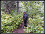
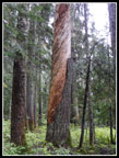
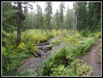
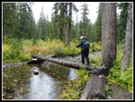
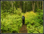
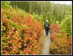
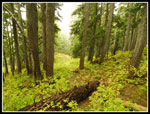
Our next decision was which route to take. The old route up Commonwealth Creek cuts off nearly a mile. With the wet weather we decided to take the shorter though steeper route. Since the first part is brushy we had on rain jackets and rain pants from the start. It had been many months since I started a hike with full rain gear and a temperature in the low 40s. I took no poles and had my umbrella out most of the day. Kim had not been on the Commonwealth Creek Trail and was not much impressed with the logged first part. As we climbed into the basin the forest changed to old growth and we was suddenly very interested. We slowed down as the forest is the destination to Kim. Though we have had a bit of rain in the mountains the past two weeks the creek was not much higher. A bridge and several easy rock hops.
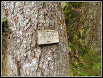
At about 1.5 miles we reached the junction. A right turn quickly brought us up to the PCT. A left turn and we started to ascend. I missed the 4km marker on a tree soon after the junction. I did find it on the way down. I know of very few kilometer distance markers on any local trails. The long gentle switchbacks on the PCT make it easy to hike up and down but make gaining elevation very slow. The next switchback to the right seems to go on endlessly. By the time we hit the next switchback we were almost up to the ridge top of the Cascade Crest. We saw several runners and more groups coming down than I expected. It was still morning. One guy had camped on the trail under Chikamin Peak the night before.
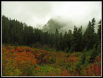
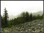
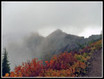
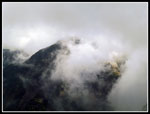
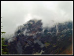
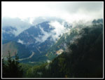
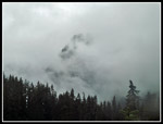
It kept raining most of the way up though we never had one of those hard rain squalls hit us. Mostly light rain and little to no wind in the forest. We took a break on the ridge crest. I was warm and so was Kim. I checked my thermometer. It read 38 degrees. It did not feel that cool, even on damp bare hands. After our stop we both cooled off significantly. The trail winds along the ridge top then drops down on the left side. The ridge above climbs very fast. A short ways along we came out of the forest into Kendall Gardens. Visibility was limited as we were inside the clouds. Previously we had a few short looks out to very cloudy Guye Peak across the valley. Snoqualmie Mountain was lost in clouds most all day. Now much higher and completely in the open we had very minimal views. Even the forested ridge we were just on went in and out of view.
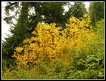
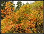
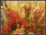
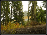
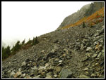
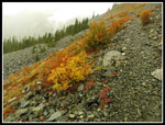
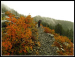
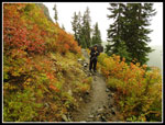
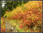
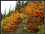
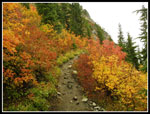
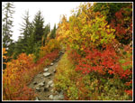
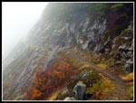
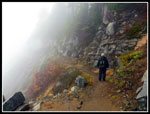
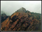
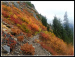
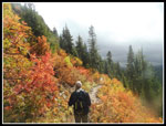
The great mountain views seen on a clear day were not there. At the same time, the wispy then dense clouds provided great views too. At one point a thick wall of clouds blew up the valley. Blew is right as once out of the forest we felt the wind. It was very chilly. I used by umbrella to block wind as much as overhead to block rain. Even Kim, who seldom bothers with an umbrella borrowed my extra to block the wind. The leaf colors in Kendall Gardens were outstanding. The trail crosses a talus field and above us were lots of red, orange, and yellow leaves. The mountain ash were especially colorful. We did not have any sunlight to really light up the leaves but even with muted lighting they were great. The trail continues under Kendall Peak then rounds a bend where Red Mountain comes more into view. Really good color along here.
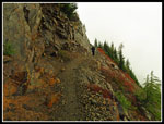
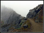
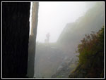
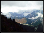
We were up to near 5000' where the snow level was forecast this day. Kim was first to notice the rain was getting bigger, whiter, and a little fluffy. The first snowfall we had seen this season. The wind moderated a lot when we rounded the bend. Now we switchbacked twice and began the traverse the rest of the way around Kendall Peak. The trail is very exposed up high and it was eerie walking in clouds with a huge drop off on one side but not being able to see down. The trail crosses to the north side of the peak for the final short hike to the Cascade Crest once again. From there one can see Alta Mountain and even east to Mt. Stuart. For a moment we could see down to bright leaf color low in Gold Creek Valley. A moment later clouds took that away.
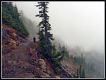
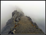
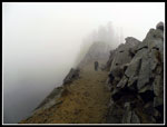
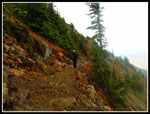
We saw a few more groups the last way over to the Kendall Katwalk. One person was standing just off the trail eating lunch. That led us to expect some higher winds on the Katwalk. As we approached the Katwalk the clouds grew even more dense. The start of the Katwalk is open on both sides. Before and after it is below a the ridge, first on the left then the right side. The wind blowing across the open section was very cold. It was much less windy when back under the ridge. No views of any kind from the Katwalk. We headed across and stopped for lunch. It was now a balmy 35 degrees. I needed to put on my puffy jacket and rain jacket to stay warm. My hand were getting very cold. I have several increasingly heavy gloves in my winter day pack. The switch over form my summer day pack the night before did not add them. I made sure to add them when I arrived home.
While we had lunch a couple people we had seen earlier passed us again. One woman had been to Ridge Lake. Our goal was just the Katwalk this day. We reached out lunch spot at 12:35 pm. We headed down at 12:55 pm. Twenty minutes was long enough at 35 degrees. Views along the Katwalk were no better going down. Other than a short climb up to the ridge north of Kendall Peak it is all downhill. I liked the climb as it allowed me to warm up a bit. We left our puffy coats on to start down and never found it necessary to take them off. The PCT is very gently graded and pretty smooth. A very easy trail to hike downhill. As we neared the junction down to the Commonwealth Trail we discussed retracing our steps or taking the longer PCT route down. The shorter route won out.
The Commonwealth route is less crowded than the PCT. We did not see anyone on it while ascending. I did not expect to see many folks when we hiked down. At the junction with the Commonwealth Trail we met a couple. A minute later a bigger group went by. Then another group. There must have been ten or more of us standing at the junction at one time. They all took off and we had solitude again the rest of the way down. At the bottom the parking lot was much fuller. We came out at about 4:30 pm. A full eight hour day on the trail. For the day we hiked just under 9 miles with about 2700' of elevation gain. After such a dry hot summer a rainy hike was fine with us. We were prepared for it. The fall colors were better than I was expecting. We saw people along the PCT but we also had long periods of solitude. The views were minimal at best but we both had a great time.
Click on thumbnails to get
larger pictures.
Trips - 2017
Home
Our next decision was which route to take. The old route up Commonwealth Creek cuts off nearly a mile. With the wet weather we decided to take the shorter though steeper route. Since the first part is brushy we had on rain jackets and rain pants from the start. It had been many months since I started a hike with full rain gear and a temperature in the low 40s. I took no poles and had my umbrella out most of the day. Kim had not been on the Commonwealth Creek Trail and was not much impressed with the logged first part. As we climbed into the basin the forest changed to old growth and we was suddenly very interested. We slowed down as the forest is the destination to Kim. Though we have had a bit of rain in the mountains the past two weeks the creek was not much higher. A bridge and several easy rock hops.
At about 1.5 miles we reached the junction. A right turn quickly brought us up to the PCT. A left turn and we started to ascend. I missed the 4km marker on a tree soon after the junction. I did find it on the way down. I know of very few kilometer distance markers on any local trails. The long gentle switchbacks on the PCT make it easy to hike up and down but make gaining elevation very slow. The next switchback to the right seems to go on endlessly. By the time we hit the next switchback we were almost up to the ridge top of the Cascade Crest. We saw several runners and more groups coming down than I expected. It was still morning. One guy had camped on the trail under Chikamin Peak the night before.
It kept raining most of the way up though we never had one of those hard rain squalls hit us. Mostly light rain and little to no wind in the forest. We took a break on the ridge crest. I was warm and so was Kim. I checked my thermometer. It read 38 degrees. It did not feel that cool, even on damp bare hands. After our stop we both cooled off significantly. The trail winds along the ridge top then drops down on the left side. The ridge above climbs very fast. A short ways along we came out of the forest into Kendall Gardens. Visibility was limited as we were inside the clouds. Previously we had a few short looks out to very cloudy Guye Peak across the valley. Snoqualmie Mountain was lost in clouds most all day. Now much higher and completely in the open we had very minimal views. Even the forested ridge we were just on went in and out of view.
The great mountain views seen on a clear day were not there. At the same time, the wispy then dense clouds provided great views too. At one point a thick wall of clouds blew up the valley. Blew is right as once out of the forest we felt the wind. It was very chilly. I used by umbrella to block wind as much as overhead to block rain. Even Kim, who seldom bothers with an umbrella borrowed my extra to block the wind. The leaf colors in Kendall Gardens were outstanding. The trail crosses a talus field and above us were lots of red, orange, and yellow leaves. The mountain ash were especially colorful. We did not have any sunlight to really light up the leaves but even with muted lighting they were great. The trail continues under Kendall Peak then rounds a bend where Red Mountain comes more into view. Really good color along here.
We were up to near 5000' where the snow level was forecast this day. Kim was first to notice the rain was getting bigger, whiter, and a little fluffy. The first snowfall we had seen this season. The wind moderated a lot when we rounded the bend. Now we switchbacked twice and began the traverse the rest of the way around Kendall Peak. The trail is very exposed up high and it was eerie walking in clouds with a huge drop off on one side but not being able to see down. The trail crosses to the north side of the peak for the final short hike to the Cascade Crest once again. From there one can see Alta Mountain and even east to Mt. Stuart. For a moment we could see down to bright leaf color low in Gold Creek Valley. A moment later clouds took that away.
We saw a few more groups the last way over to the Kendall Katwalk. One person was standing just off the trail eating lunch. That led us to expect some higher winds on the Katwalk. As we approached the Katwalk the clouds grew even more dense. The start of the Katwalk is open on both sides. Before and after it is below a the ridge, first on the left then the right side. The wind blowing across the open section was very cold. It was much less windy when back under the ridge. No views of any kind from the Katwalk. We headed across and stopped for lunch. It was now a balmy 35 degrees. I needed to put on my puffy jacket and rain jacket to stay warm. My hand were getting very cold. I have several increasingly heavy gloves in my winter day pack. The switch over form my summer day pack the night before did not add them. I made sure to add them when I arrived home.
While we had lunch a couple people we had seen earlier passed us again. One woman had been to Ridge Lake. Our goal was just the Katwalk this day. We reached out lunch spot at 12:35 pm. We headed down at 12:55 pm. Twenty minutes was long enough at 35 degrees. Views along the Katwalk were no better going down. Other than a short climb up to the ridge north of Kendall Peak it is all downhill. I liked the climb as it allowed me to warm up a bit. We left our puffy coats on to start down and never found it necessary to take them off. The PCT is very gently graded and pretty smooth. A very easy trail to hike downhill. As we neared the junction down to the Commonwealth Trail we discussed retracing our steps or taking the longer PCT route down. The shorter route won out.
The Commonwealth route is less crowded than the PCT. We did not see anyone on it while ascending. I did not expect to see many folks when we hiked down. At the junction with the Commonwealth Trail we met a couple. A minute later a bigger group went by. Then another group. There must have been ten or more of us standing at the junction at one time. They all took off and we had solitude again the rest of the way down. At the bottom the parking lot was much fuller. We came out at about 4:30 pm. A full eight hour day on the trail. For the day we hiked just under 9 miles with about 2700' of elevation gain. After such a dry hot summer a rainy hike was fine with us. We were prepared for it. The fall colors were better than I was expecting. We saw people along the PCT but we also had long periods of solitude. The views were minimal at best but we both had a great time.
 Soaking Wet |
 Spiral Tree |
 Commonwealth Creek |
 Kim Crossing Creek |
 Colorful Brush |
 First Good Colors |
 Add In Some Orange |
 Now For Some Red |
 Colorful Meadow |
 Cloudy Guye Peak |
 Bright Forest Floor |
 Kendall Gardens Ahead |
 Out Into The Talus |
 Clouds All Around |
 Color Lines Route |
 Kim In Wind & Rain |
 Back On Dirt Trail |
 Really Good Colors |
 Many Colors |
 Looking Back |
 Better Than Expected |
 Red Out Of Clouds |
 Narrow Trail |
 Clouds Are Scenery |
 Cloudy Guye |
 Approaching Katwalk |
 What View? |
 Kim On Katwalk |
 North End Of Katwalk |
 Hiker In Clouds |
 Kim Back On Katwalk |
 Snoqualmie Mountain |
 Very Red Mountain |
 Snoqualmie Pass |
 Less Cloudy |
 Swirling Clouds |
 Lit Up Now |
 Momentary Sunshine |
 Guye Almost Gone |
 4km Marker |
Trips - 2017
Home