7/28-30/17
Gary
and John were free for a three
day backpacking trip. Our first backpacking trip together in two years.
We debated several overnight trips and settled on a three day trip to
Lost Creek Ridge. Neither John nor I had been on the trail. Gary's last
visit was in 2007. Since there were no trip reports we did not know
about the snow conditions. Some helpful info from a post at
NWHikers.net gave us confidence that we likely could make it to Lake
Byrne. We met in North Seattle on Friday morning at 7:00 am and headed
north. Traffic was not bad and we went through Granite Falls and up the
Mountain Loop Highway. The gravel section beyond Barlow Pass is in
excellent condition. We were surprised to see the campgrounds at Verlot
full and many folks camping along the highway on a Friday morning. The
NF Sauk Road was washed out earlier this year but with a few rough
spots it is in fine shape too. We arrived at the 1850' trailhead at
8:48 am. There were only four or five cars there. We packed up and
started up the trail at 9:05 am.
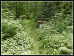
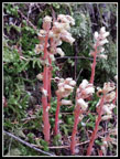
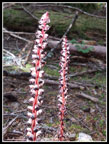
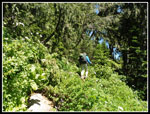
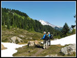
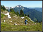
The route is nearly flat at first as it crosses the valley floor. It is a little brushy. There were a few nettles. I was the only one in shorts and made it through without any stings. The trail soon begins the climb and does so for the next 3500' of gain or so. We climbed above the underbrush and the bare forest floor was much like the trail up Sulphur Mountain we hiked several weeks earlier. As on that and every other trip I have been on the past month we found lots of saprophytes. Candystick was especially abundant. We stopped for some photos but mostly kept moving. There were few logs down across the trail. One very big one had a chunk cut out of the bottom. It was still a tight fit with backpacks on for three guys each over six feet tall. At about 3 miles we reached Bingley Gap. The gap is forested but made a good spot for a break.
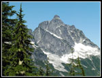
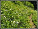
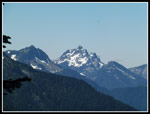
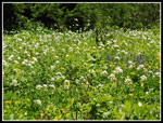
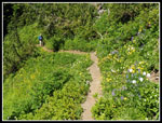
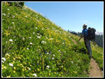
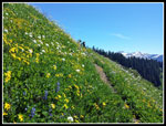
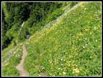
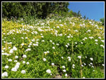
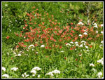
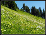
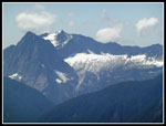
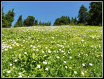
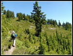
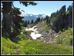
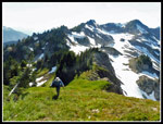
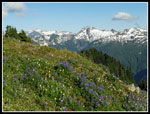
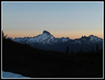
The trail climbs up the ridge on a series of switchbacks. Not too far above the gap we reached an opening on the ridge where we could see out. Mt. Pugh was clearly in sight. Whitechuck Mountain is just to the north as well. Other than a few low clouds the sky was clear. More climbing brought us finally out of the forest. Now we had some open flower filled slopes and views south to Sloan and Bedal Peaks. I was not sure what to expect for the wildflower show and we were pleasantly surprised. Not a lot of brightly colored Indian paintbrush and lupine but huge fields of white Sitka Valerian and yellow flowers. In many places the flowers were more visible than all the green leaves. The show went on for miles and miles. The trail in the forest is in great shape. Out in the open it is narrow, sloughing in spots, and overgrown. Throw in some big steps up and down and the hiking gets a bit tedious. On the other hand the flower show was a marvel.
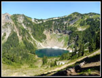
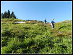
With some ups and downs we continued climbing though now well below the ridge top for the most part. Views south improved with that elevation and we could see southwest to Del Campo, Sperry, Vesper, and Big Four Peaks. At least those were peaks I could identify. At a junction Gary led up uphill a short way to the ridge top. Here we were looking down on Round Lake. A group of day hikers with a dog left just ahead of us and we likely saw them down at the lake. It was 12:45 when we arrived. While we did not take a lot of photo stops in the forest we sure did once out in the open wildflower fields. The 3:40 we took to hike less than five miles attests to that. One set of switchbacks was especially memorable as the route climbed up an incredibly dense flower field.
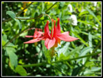
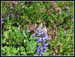
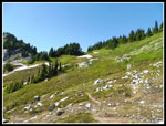
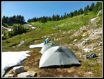
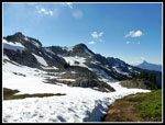
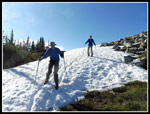
We took a lunch break at the Round Lake overview. We had all day and were only planning on going another couple miles to our expected open campsite. While the most colorful flowers were not in high supply we did see some nice stands of orange tiger lilies and red columbine. Beyond Round Lake the trail crossed open flower fields and dropped into several basins. Latter ones had some snow left. Not enough to cause any traction or navigation problems. There were creeks running constantly so finding water is no problem at this time. We continued east then the trail turned north. Gary recognized we were near the spot he planned to camp. In 2007 he hiked by this spot and recorded the location for future use. We stopped and pumped water. The day was getting warm and we were about out of water. The trail turned back to the east and we fanned out to look for the campsite. There was still patchy snow on the hillside. We found the spot. Just off the trail and with a creek running right next to it at an elevation of 5800'. Room for our three tents and some snow covering part of the flat spots.
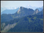
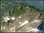
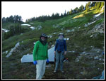
It was about 3:00 pm when we started setting up our tents. The bugs had not been too bad while we were moving. Now that we had stopped they became much more annoying. The flies were not biting hard or much at all at least. We discussed scrambling up Point 6343 after dinner. At 4:35 pm we decided to head on up to the low saddle to the northwest. Just a few hundred feet of gain on open grassy slopes with a little snow. At the saddle we saw a whole different world. Instead of the grassy slopes with patches of evergreen trees we saw the north side of Lost Creek Ridge. To the west was a steep and very snowy slope with a rocky basin just a little below us. The next rounded peak to the west turned out to be Breccia Peak. It turned out that friends Roger, Barb, Elle, and a few others started up the trail just before we arrived. They day hiked up Breccia Peak. The ridge was narrow in spots but seemed to continue east to Point 6343, also known as Zi iob Peak I later discovered.We saw the tower atop it on the hike up. We decided that after 4500' of gain so far if we headed down we would not be up for an after dinner trip up another 500'. We headed up the ridge.
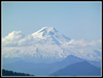
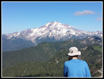
The ridge route was not bad. A few spots looked questionable but there was an easy enough way around them. We soon topped out on the 6343' summit. It is big and fairly flat on top. We arrived on top at 5:15 pm. The views were outstanding. To the north were Baker and Shuksan. Meadow Mountains ridge, Lime Ridge, and more. The Whitechuck River Valley was below us to the north. Glacier Peak dominated the view east. This is a great viewpoint of Glacier. To the south were Black and Red Mountains plus Sloan and Bedal. To the left of Sloan we could see the Monte Cristo Peaks. Gary could make out the Olympic Mountains far to the west. We stayed up there until 6:00 pm. Rather than follow the ridge back we chose a much more direct route right down the south slope.
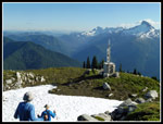
A little below the summit we found the small building with solar panels and a radio tower. Some kind of communications station. The route down was great most of the way though a little steep near the bottom. We were back in camp at 6:30 pm. Next came dinner then we went for the bug head nets. It was very warm in camp until the sun went behind the ridge then it cooled very fast. We managed to stay outside until 9:00 pm It was dark soon after. Much to our surprise our tents were covered with condensation when we went to bed. A great first day of the trip. We hiked 6.9 miles with 4700' of gain.
Click on thumbnails to get
larger pictures.
Day 2
Trips - 2017
Home
The route is nearly flat at first as it crosses the valley floor. It is a little brushy. There were a few nettles. I was the only one in shorts and made it through without any stings. The trail soon begins the climb and does so for the next 3500' of gain or so. We climbed above the underbrush and the bare forest floor was much like the trail up Sulphur Mountain we hiked several weeks earlier. As on that and every other trip I have been on the past month we found lots of saprophytes. Candystick was especially abundant. We stopped for some photos but mostly kept moving. There were few logs down across the trail. One very big one had a chunk cut out of the bottom. It was still a tight fit with backpacks on for three guys each over six feet tall. At about 3 miles we reached Bingley Gap. The gap is forested but made a good spot for a break.
The trail climbs up the ridge on a series of switchbacks. Not too far above the gap we reached an opening on the ridge where we could see out. Mt. Pugh was clearly in sight. Whitechuck Mountain is just to the north as well. Other than a few low clouds the sky was clear. More climbing brought us finally out of the forest. Now we had some open flower filled slopes and views south to Sloan and Bedal Peaks. I was not sure what to expect for the wildflower show and we were pleasantly surprised. Not a lot of brightly colored Indian paintbrush and lupine but huge fields of white Sitka Valerian and yellow flowers. In many places the flowers were more visible than all the green leaves. The show went on for miles and miles. The trail in the forest is in great shape. Out in the open it is narrow, sloughing in spots, and overgrown. Throw in some big steps up and down and the hiking gets a bit tedious. On the other hand the flower show was a marvel.
With some ups and downs we continued climbing though now well below the ridge top for the most part. Views south improved with that elevation and we could see southwest to Del Campo, Sperry, Vesper, and Big Four Peaks. At least those were peaks I could identify. At a junction Gary led up uphill a short way to the ridge top. Here we were looking down on Round Lake. A group of day hikers with a dog left just ahead of us and we likely saw them down at the lake. It was 12:45 when we arrived. While we did not take a lot of photo stops in the forest we sure did once out in the open wildflower fields. The 3:40 we took to hike less than five miles attests to that. One set of switchbacks was especially memorable as the route climbed up an incredibly dense flower field.
We took a lunch break at the Round Lake overview. We had all day and were only planning on going another couple miles to our expected open campsite. While the most colorful flowers were not in high supply we did see some nice stands of orange tiger lilies and red columbine. Beyond Round Lake the trail crossed open flower fields and dropped into several basins. Latter ones had some snow left. Not enough to cause any traction or navigation problems. There were creeks running constantly so finding water is no problem at this time. We continued east then the trail turned north. Gary recognized we were near the spot he planned to camp. In 2007 he hiked by this spot and recorded the location for future use. We stopped and pumped water. The day was getting warm and we were about out of water. The trail turned back to the east and we fanned out to look for the campsite. There was still patchy snow on the hillside. We found the spot. Just off the trail and with a creek running right next to it at an elevation of 5800'. Room for our three tents and some snow covering part of the flat spots.
It was about 3:00 pm when we started setting up our tents. The bugs had not been too bad while we were moving. Now that we had stopped they became much more annoying. The flies were not biting hard or much at all at least. We discussed scrambling up Point 6343 after dinner. At 4:35 pm we decided to head on up to the low saddle to the northwest. Just a few hundred feet of gain on open grassy slopes with a little snow. At the saddle we saw a whole different world. Instead of the grassy slopes with patches of evergreen trees we saw the north side of Lost Creek Ridge. To the west was a steep and very snowy slope with a rocky basin just a little below us. The next rounded peak to the west turned out to be Breccia Peak. It turned out that friends Roger, Barb, Elle, and a few others started up the trail just before we arrived. They day hiked up Breccia Peak. The ridge was narrow in spots but seemed to continue east to Point 6343, also known as Zi iob Peak I later discovered.We saw the tower atop it on the hike up. We decided that after 4500' of gain so far if we headed down we would not be up for an after dinner trip up another 500'. We headed up the ridge.
The ridge route was not bad. A few spots looked questionable but there was an easy enough way around them. We soon topped out on the 6343' summit. It is big and fairly flat on top. We arrived on top at 5:15 pm. The views were outstanding. To the north were Baker and Shuksan. Meadow Mountains ridge, Lime Ridge, and more. The Whitechuck River Valley was below us to the north. Glacier Peak dominated the view east. This is a great viewpoint of Glacier. To the south were Black and Red Mountains plus Sloan and Bedal. To the left of Sloan we could see the Monte Cristo Peaks. Gary could make out the Olympic Mountains far to the west. We stayed up there until 6:00 pm. Rather than follow the ridge back we chose a much more direct route right down the south slope.
A little below the summit we found the small building with solar panels and a radio tower. Some kind of communications station. The route down was great most of the way though a little steep near the bottom. We were back in camp at 6:30 pm. Next came dinner then we went for the bug head nets. It was very warm in camp until the sun went behind the ridge then it cooled very fast. We managed to stay outside until 9:00 pm It was dark soon after. Much to our surprise our tents were covered with condensation when we went to bed. A great first day of the trip. We hiked 6.9 miles with 4700' of gain.
 Trailhead |
 Pinesap |
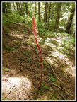
 Candystick |
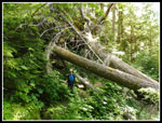 Down Trees |
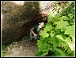 John Crawls Under |
 Pinedrop |
 Bare Forest Floor |
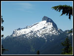
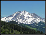
 Mt. Pugh |
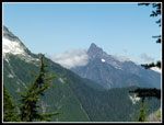 Whitechuck Mountain |
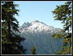 Bedal Peak |
 Sloan Peak |
 Wildflowers Begin |
 Del Campo Peak |
 Valerian Everywhere! |
 Columbine Close Up |
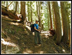
 John On The Trail |
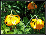 Tiger Lilies |
 More Meadows |
 Big Columbine Patch |
 Painted Traverse |
 Gary & Wildflowers |
 White & Yellow |
 More Color |
 Wow! |
 More Columbine |
 Heather & Lupine |
 Round Lake |
 Even More Flowers |
 Sperry & Vesper Peaks |
 Color Up The Slopes |
 John In Meadow |
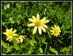 Yellow Flowers |
 Glacier Peak |
 That's The Trail |
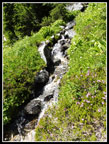 Cascading Creek |
 Leveler Meadows |
 Meadows & Snow |
 Above The Snow |
 View Near Camp |
 Campsite |
 Heading To Saddle |
 Instant Winter |
 Mt. Baker |
 Circle Peak |
 Ascending Ridge |
 Gary & Glacier Peak |
 Snowy Trail |
 Radio Repeater Tower |
 Standing Glissade |
 Lupine & Peaks |
 Coming Down |
 Beekeepers? |
 Sunset Colors |
Day 2
Trips - 2017
Home