3-19-17
An
actual sunny day and considerable avalanche danger. Where to go hiking?
John was free and we decided to hike the Rattlesnake Mountain Trail
from the east to west end. We met at 7:50 am at the Snoqualmie Point
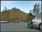
Trailhead. The first row of parking was already full. We drove through
North Bend and headed up the hill to Rattlesnake Lake. Not only was the
first lot full but the second one too. There were already a dozen cars
parked along the road. It was just after 8:00 am. Since our last trip
along the top of Rattlesnake Mountain there was considerable timber
harvesting. We knew the cut was large but had not seen it yet. To be
safe, we brought snowshoes and microspikes. The former we did not use.
The latter were very helpful. We were on our way at about 8:15 am.
Almost immediately we saw folks already almost down after an early
morning hike up. The number of folks heading up meant passing quite a
few groups. It was right about 32 degrees at the start but a steady
uphill pace had us warm enough. The lack of winter snow the past few
years meant I was not all that used to having a normal winter weight
pack.
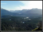
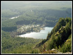
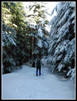
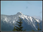
We made reasonable progress moving through the crowd. We reached the lower ledge a couple minutes after 9:00 am. Several groups left as we were arriving and it was not too crowded on the ledge. The recent snow level was clearly marked on the trees of surrounding peaks. White tops with green below. There were some wispy clouds but mostly blue sky. We have had precious few days like that this winter. We shed layers, took some photos, and were quickly back on the trail heading higher. We took one more short stop at the upper ledge. Some nice views out. It looked like every spot at the lower ledge now had someone on it. Our timing was looking pretty good. The upper ledge is usually empty but there were several other groups already there when we arrived.
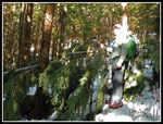
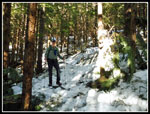
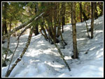
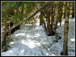
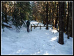
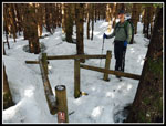
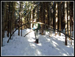
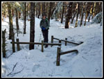
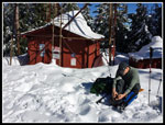
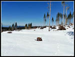
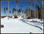
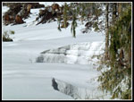
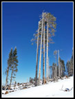
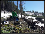
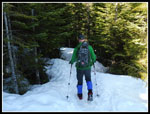
Now we left most of the crowds behind. Not too far above the upper ledge we reached the first snow. It soon covered the trail. It was well packed down and very slick. We quickly stopped to put on microspikes. John brought along a small 6" hand saw and he put it to good use. There are a number of small trees across the trail. Some are bent over and frozen in the icy snow. When it melts they will pop back up. Others have fallen over the winter. John sawed and we both moved small trees and logs off the trail. Several of them had folks going off trail to get around. Some were too big but the route is better than it was. This slowed us down but was well worth the effort. A couple groups passed us by as we worked. There are wooden "gates" on both sides of the first road crossing. Only the tops were showing. The snow was a good 4-5 feet deep.
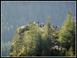
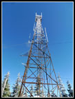
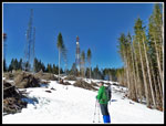
After the two road crossings it is just up the gentle ridge to the top of East Peak. As we neared the peak the packed down track left the summer trail and went straight up to the tower. A shorter route to the top. We arrived to find a few folks there. After the forested walk we were out in the sunshine on top. Our thermometers showed about 35 degrees but with no wind and the sunshine it felt very pleasant. The building was half way buried in snow. The top of the tower was white with fresh frozen icy snow. As the day warmed up we saw ice falling off each of the towers we passed. Not a good idea to be too close. It was only 10:45 am but we took a food break. We stayed a while as we were not that excited to go back into the cool forest.
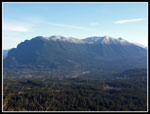
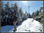
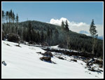
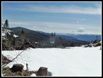
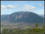
Soon enough we headed along the ridge to the viewpoint with a bench. No bench this day. It was well buried under the snow. A hiker arrived from the other end of the trail and mentioned the snow was soft near the East Peak but he did fine without snowshoes. We found this to be true. We did post hole occasionally but not enough to take the time to put on our snowshoes. A short way down we took the side trail to Windy Landing. Some pretty good views. Trees will begin to block the view in a few years but with the snow we were high enough to have good views out. We could see from Granite Mountain around to Mt. Si and North Bend. We headed back to the trail and continued downhill in forest on the old route. Things changed radically when we reached the logged area. The footprints we were following split. Some went uphill and some contoured at a steady level. It all looked so foreign without trees. As many times as I have hiked along the ridge I had no idea where I was on it. We chose to head uphill.
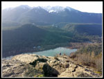
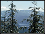
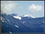
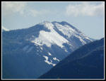
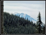
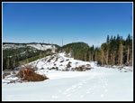
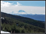
The route around slash piles took us to a small tower then dropped back down again. We headed down towards the lower path we had not taken. As we descended we could see the East Peak tower and then Mt. Rainier. They were never visible before from the ridge top route. Views down to the Cedar River Watershed were excellent. Other than at Rattlesnake Ledge it is very hard to see. Not any more. The snow in the open was not as deep as I expected. It was also very well compacted. We had very little post holing from there on. The logging was on the left side of the ridge. The other side above I-90 has not been cut. Our views included the towers of West Rattlesnake Mountain. The cutting goes right up to the towers. East Tiger Mountain and Tiger 1 also came into view. We came to a spot where there was bare ground and stopped for lunch. It was about 12:15 pm.
There was almost no wind. The sun was shining and warm. The snow around us was bright but we were sitting off the snow. Absolutely perfect conditions. With just a light long sleeve shirt and a windshirt I was all set. It was so perfect that we did not want to leave. Half an hour went by then an full hour. Then another half hour. After 1:45 we finally decided to head on. We still had 4.5 miles to go. We dropped down to the low spot then started climbing up towards the West Peak towers. I expected to find the spot where the old trail to Grand Prospect left the road. It is not obvious. We did see an old wooden post at the edge of the forest and a few footprints heading that way. No plastic tape or sign was seen. it would be easy going in the other direction but not so easy in this direction if not for the footprints. Regardless, we had other plans.
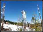
We continued up the slope towards the towers. There is an obvious switchbacking road but why not go straight up on the snow? We met the road near the top. All the cutting has opened up views from the towers. Not to the west but to the south and east. On one visit in March 2008 we found snow all the way to the barbed wire atop the fences. Not nearly that high this day. Instead of eight feet of snow we had about half that at most. Rather than retrace our steps, we took the shortcut down to Grand Prospect. The old straight up cut has been lost in the brush in the summer but with the snow it was easy to drop down. Easy with a few down logs to get over. As expected, we were not along at Grand Prospect. We took a few photos and headed down.
The trail down was very hard packed and icy snow. We had microspikes and had no trouble. Those without traction devices were having a tough time. When we left the old road and entered forest the solid snow cover turned to some icy patches. They were well spaced. Before long we stopped to remove our microspikes. There was more snow near the bridge but soon after crossing it was back to bare ground. The rest of the way down was easy enough. I did show John a long cut that added a little time to our descent. We finally reached the bottom at 4:18 pm. We took 8:03 to hike a little over 11 miles with about 3000' of elevation gain. The parking lot was mostly full with many more cars parked outside the gate.
We still had to drive down to North Bend then up to Rattlesnake Lake to retrieve John's car. As we approached Rattlesnake Lake the line of cars began. Probably at least half a mile before the parking lots. The line of cars continued beyond the parking entrance on both sides of the road. The lots were almost entirely full. Folks were parking along and in the road between lots. It as a zoo. The most cars I have seen at Rattlesnake Lake. This in mid March at 4:35 pm on a Sunday. It has been a dark and damp winter and it looked like everyone wanted to get outside this day. The lots are always popular but this was a bit ridiculous.
The day was a great success. We did a rare one way trip on a cool but very sunny day. Even 45 degrees on the ridge top in the sunshine felt like spring. I had been meaning to check out the logging site and while a nice forested walk is now gone the payback is the views that have been opened up. As fast as the views on Tiger Mountain have been closing up due to growing trees they are huge on Rattlesnake now. The snowshoes ended up being dead weight but were worth taking as a mile of post holing is a nightmare if the conditions were bad. Many more people seen than expected at the start but we had lots of solitude for most of the day. All in all, a great way to send out winter and welcome in spiring.
Click on thumbnails to get
larger pictures.
Trips - 2017
Home
We made reasonable progress moving through the crowd. We reached the lower ledge a couple minutes after 9:00 am. Several groups left as we were arriving and it was not too crowded on the ledge. The recent snow level was clearly marked on the trees of surrounding peaks. White tops with green below. There were some wispy clouds but mostly blue sky. We have had precious few days like that this winter. We shed layers, took some photos, and were quickly back on the trail heading higher. We took one more short stop at the upper ledge. Some nice views out. It looked like every spot at the lower ledge now had someone on it. Our timing was looking pretty good. The upper ledge is usually empty but there were several other groups already there when we arrived.
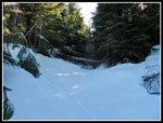
Now we left most of the crowds behind. Not too far above the upper ledge we reached the first snow. It soon covered the trail. It was well packed down and very slick. We quickly stopped to put on microspikes. John brought along a small 6" hand saw and he put it to good use. There are a number of small trees across the trail. Some are bent over and frozen in the icy snow. When it melts they will pop back up. Others have fallen over the winter. John sawed and we both moved small trees and logs off the trail. Several of them had folks going off trail to get around. Some were too big but the route is better than it was. This slowed us down but was well worth the effort. A couple groups passed us by as we worked. There are wooden "gates" on both sides of the first road crossing. Only the tops were showing. The snow was a good 4-5 feet deep.
After the two road crossings it is just up the gentle ridge to the top of East Peak. As we neared the peak the packed down track left the summer trail and went straight up to the tower. A shorter route to the top. We arrived to find a few folks there. After the forested walk we were out in the sunshine on top. Our thermometers showed about 35 degrees but with no wind and the sunshine it felt very pleasant. The building was half way buried in snow. The top of the tower was white with fresh frozen icy snow. As the day warmed up we saw ice falling off each of the towers we passed. Not a good idea to be too close. It was only 10:45 am but we took a food break. We stayed a while as we were not that excited to go back into the cool forest.
Soon enough we headed along the ridge to the viewpoint with a bench. No bench this day. It was well buried under the snow. A hiker arrived from the other end of the trail and mentioned the snow was soft near the East Peak but he did fine without snowshoes. We found this to be true. We did post hole occasionally but not enough to take the time to put on our snowshoes. A short way down we took the side trail to Windy Landing. Some pretty good views. Trees will begin to block the view in a few years but with the snow we were high enough to have good views out. We could see from Granite Mountain around to Mt. Si and North Bend. We headed back to the trail and continued downhill in forest on the old route. Things changed radically when we reached the logged area. The footprints we were following split. Some went uphill and some contoured at a steady level. It all looked so foreign without trees. As many times as I have hiked along the ridge I had no idea where I was on it. We chose to head uphill.
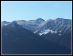
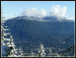
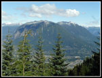
The route around slash piles took us to a small tower then dropped back down again. We headed down towards the lower path we had not taken. As we descended we could see the East Peak tower and then Mt. Rainier. They were never visible before from the ridge top route. Views down to the Cedar River Watershed were excellent. Other than at Rattlesnake Ledge it is very hard to see. Not any more. The snow in the open was not as deep as I expected. It was also very well compacted. We had very little post holing from there on. The logging was on the left side of the ridge. The other side above I-90 has not been cut. Our views included the towers of West Rattlesnake Mountain. The cutting goes right up to the towers. East Tiger Mountain and Tiger 1 also came into view. We came to a spot where there was bare ground and stopped for lunch. It was about 12:15 pm.
There was almost no wind. The sun was shining and warm. The snow around us was bright but we were sitting off the snow. Absolutely perfect conditions. With just a light long sleeve shirt and a windshirt I was all set. It was so perfect that we did not want to leave. Half an hour went by then an full hour. Then another half hour. After 1:45 we finally decided to head on. We still had 4.5 miles to go. We dropped down to the low spot then started climbing up towards the West Peak towers. I expected to find the spot where the old trail to Grand Prospect left the road. It is not obvious. We did see an old wooden post at the edge of the forest and a few footprints heading that way. No plastic tape or sign was seen. it would be easy going in the other direction but not so easy in this direction if not for the footprints. Regardless, we had other plans.
We continued up the slope towards the towers. There is an obvious switchbacking road but why not go straight up on the snow? We met the road near the top. All the cutting has opened up views from the towers. Not to the west but to the south and east. On one visit in March 2008 we found snow all the way to the barbed wire atop the fences. Not nearly that high this day. Instead of eight feet of snow we had about half that at most. Rather than retrace our steps, we took the shortcut down to Grand Prospect. The old straight up cut has been lost in the brush in the summer but with the snow it was easy to drop down. Easy with a few down logs to get over. As expected, we were not along at Grand Prospect. We took a few photos and headed down.
The trail down was very hard packed and icy snow. We had microspikes and had no trouble. Those without traction devices were having a tough time. When we left the old road and entered forest the solid snow cover turned to some icy patches. They were well spaced. Before long we stopped to remove our microspikes. There was more snow near the bridge but soon after crossing it was back to bare ground. The rest of the way down was easy enough. I did show John a long cut that added a little time to our descent. We finally reached the bottom at 4:18 pm. We took 8:03 to hike a little over 11 miles with about 3000' of elevation gain. The parking lot was mostly full with many more cars parked outside the gate.
We still had to drive down to North Bend then up to Rattlesnake Lake to retrieve John's car. As we approached Rattlesnake Lake the line of cars began. Probably at least half a mile before the parking lots. The line of cars continued beyond the parking entrance on both sides of the road. The lots were almost entirely full. Folks were parking along and in the road between lots. It as a zoo. The most cars I have seen at Rattlesnake Lake. This in mid March at 4:35 pm on a Sunday. It has been a dark and damp winter and it looked like everyone wanted to get outside this day. The lots are always popular but this was a bit ridiculous.
The day was a great success. We did a rare one way trip on a cool but very sunny day. Even 45 degrees on the ridge top in the sunshine felt like spring. I had been meaning to check out the logging site and while a nice forested walk is now gone the payback is the views that have been opened up. As fast as the views on Tiger Mountain have been closing up due to growing trees they are huge on Rattlesnake now. The snowshoes ended up being dead weight but were worth taking as a mile of post holing is a nightmare if the conditions were bad. Many more people seen than expected at the start but we had lots of solitude for most of the day. All in all, a great way to send out winter and welcome in spiring.
 Parking Lot |
 View From Ledge |
 Si & Teneriffe |
 Lake From Ledge |
 Lower Ledge |
 Zoomed Ledge |
 Watershed Peaks |
 Before Sawing |
 After Sawing |
 Another Before Shot |
 And After |
 Deep Post Hole |
 Gate & Snow Pack |
 Second Gate |
 Bent Over Trees |
 Final Gate |
 East Peak |
 East Peak Tower |
 Mt. Si From Viewpoint |
 Summit Ridge |
 Heading On |
 Chester Morse Lake |
 Granite Mountain |
 Bandera Mountain |
 Into The Logged Area |
 Diverging Paths |
 Crevasse! |
 Mt. Rainier In Sight |
 Icy Trees Blue Sky |
 Distant East Peak |
 Distant West Peak |
 Rainier Again |
 Time For A Long Break |
 Below West Peak |
 View Southeast |
 Weather Station? |
 Mt. Teneriffe Summit |
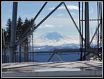 Framed Rainier |
 Down From West Peak |
 Si From Grand Prospect |
 Heading Down |
 Last Si Shot |
Trips - 2017
Home