4-29-18
An
overcast day with some showers
but not nearly as much rain as the day before. I needed to get home by
early afternoon so chose a hike out of Tiger Summit. I did this loop
last spring for the first time. The wildflower display was pretty good.
I did not get on the road until 8:00 am. Out to I-90 then onto Highway
18 to the high point at Tiger Summit. The outer parking area was mostly
full. I navigated through the lakes/puddles and on to the 1375' inner
parking lot where a Discover Pass is required. That one was much less
crowded. I was on the trail at 8:40 am. This day was all about mountain
bikers and not hikers. I saw very few hikers on my entire loop. I did
see quite a few bikers. Still, I had a lot of solitude between seeing
anyone.
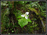
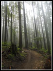
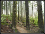
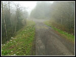
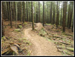
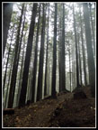
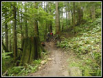
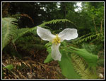
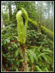
Out the Connector Trail to the road and on to the NW Timber Trail. In just a few minutes I turned uphill on the Master Link Trail. This point is where the loop would be completed ten miles later. The forecast was for a 10 mph wind out of the southwest. I was on the northeast side of Tiger. I had almost no wind accept at the summit. Trillium was the wildflower of the day. I saw them on much of the route. Especially at lower elevations. The trail is very gentle as it makes long gentle switchbacks to slowly gain elevation. It makes for some fast hiking. Half a dozen bike groups passed my by on the ascent. More than usual but still not that many. As I climbed I entered the clouds. The forest became very misty. Though it rained most of the previous day, there was not much water dripping from the trees. I never did need rain gear or an umbrella.
Near the top of the Master Link I looked for the big patch of skunk cabbage. It was blooming lots of yellow spathes. There is a huge patch near the gate in the lower parking lot but I did not check to see how that was doing. I did pass half a dozen wetlands with yellow skunk cabbage on my route. On my two previous trips up this route this winter I hit snow by the road crossing to the Quick Link Trail. This day all the snow is gone. It made for much faster hiking. I crossed the road onto the Quick Link and it was even more cloudy/misty now. A few more bike groups went by on my way up to the main road. Once on the road it was a little uphill then down to the road junction. The big puddle there is almost a lake right now. Then I just had .70 miles to the summit of East Tiger gaining a final 450'.
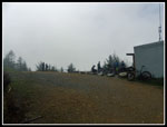
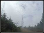
A couple bikers caught up with me just as the road gets steeper and I was able to pull away form them. I seldom can hike faster than bikers, even uphill. I arrived at the very cloudy summit to find several groups of mountain bikers. More arrived and then even more. The tower was visible but the top was partly in clouds. I had zero view out for the third time this winter. It was 10:18 am when I arrived on top. Four miles up with about 1650' of gain in 1:38. Not bad considering a number of photo stops. After a quick food and water break I packed up to head down. There were probably 15 bikers on top by then. I dropped down to the where the bike trail crosses the road and turned around. I wanted to get in 2000' of gain and need another 100' somewhere. Well, it was 100' back to the summit. Up I went for the second time.
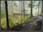
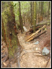
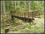
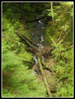
Now it was downhill to the trail crossing again. I turned left onto the East Tiger Trail and a few minutes later turned right onto the Off The Grid Trail. This one is a long downhill with some jumps built in. I don't think I will be biking it any time soon. The bikers I saw had no trouble with the trail. It does mean some big steps down for a hiker. It also means be alert to bikes going very fast. The Master and Quick Link Trails are uphill only for bikes and both directions for hikers. This one allows bikes to go downhill as fast as they can. Fortunately, fast bikes make lots of noise I had no problem stepping off the trail when needed. On my trip last year I noticed all the bridges on the loop. This time I made a point to photograph them all. The total is 13 bridges and two of them crossed in both directions for 15 bridge crossings. I only counted ones at least 15-20' long. The longest one was about 75' long.
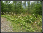
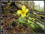
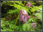
I was passed by three hikes on the OTG Trail. It was a family with a elementary school aged child. They were out running. It is about 2.5 miles from the summit of East Tiger down to the end of the OTG at a road Crossing. Picnic tables and a trail board here but without a map. The summit has a big map without the recent trails but a smaller one with all of them. The trailhead has the big map but not the more complete one. Though I would pass several more junctions the rest of the way I knew which ones to take without consulting a map. For a first visit, a map can be very necessary. There was a big patch of coltsfoot in bloom here. The runner family stopped here and took off ahead of me. Below the road the wildflower shop picked up again. I saw a few bleeding hearts in bloom and lots more trillium and some yellow violets.
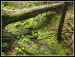
The Fully Rigid Trail drops first and then I turned onto the Joy Ride Trail. The runners were just in sight and then turned onto the Silent Swamp Trail. I hope they knew where they were going as it heads away from Tiger Summit. It took longer than I expected to get down to the NW Timber Trail. Some of the best bridges are on Joy Ride and NW Timber. No two are quite the same. Some have wire side rails. Some have a bridge with wooden hand rails connected to a bridge without them. Several cross well above creeks above dark forested ravines. At the NW Timber Trail the bike traffic picked up again. The last two miles do not have much elevation gain. There are a number of small ups and downs but little overall elevation change.
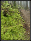
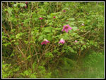
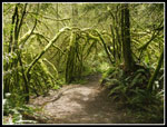
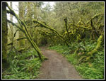
a few openings provide looks across the valley of Highway 18 to Rattlesnake Mountain. In one spot I could see the towers atop West Rattlesnake Mountain. The open spots also had a lot of red currant in bloom. The trillium continued as well. There are some moss covered arbors along this stretch that rival any I have seen before. The recent rain and overcast really brought out the colors. I started to see a few hikers in the last mile. My loop was closed when I reached the start of the Master Link Trail once again. Now just under half a mile back to the car. I arrived at the trailhead at 1:08 pm. 11 mile with 2000' of gain done by just after 1:00 pm. Not too bad. Traffic was light and I was home by 2:00 pm.
This is a mountain bike route and many hikers will not like for that reason. It is a pretty good spring wildflower hike and a short drive from Seattle. Not a trail I will do often but a lot of fun on a cloudy spring day.
Click on thumbnails to get
larger pictures.
Trips - 2018
Home
Out the Connector Trail to the road and on to the NW Timber Trail. In just a few minutes I turned uphill on the Master Link Trail. This point is where the loop would be completed ten miles later. The forecast was for a 10 mph wind out of the southwest. I was on the northeast side of Tiger. I had almost no wind accept at the summit. Trillium was the wildflower of the day. I saw them on much of the route. Especially at lower elevations. The trail is very gentle as it makes long gentle switchbacks to slowly gain elevation. It makes for some fast hiking. Half a dozen bike groups passed my by on the ascent. More than usual but still not that many. As I climbed I entered the clouds. The forest became very misty. Though it rained most of the previous day, there was not much water dripping from the trees. I never did need rain gear or an umbrella.
Near the top of the Master Link I looked for the big patch of skunk cabbage. It was blooming lots of yellow spathes. There is a huge patch near the gate in the lower parking lot but I did not check to see how that was doing. I did pass half a dozen wetlands with yellow skunk cabbage on my route. On my two previous trips up this route this winter I hit snow by the road crossing to the Quick Link Trail. This day all the snow is gone. It made for much faster hiking. I crossed the road onto the Quick Link and it was even more cloudy/misty now. A few more bike groups went by on my way up to the main road. Once on the road it was a little uphill then down to the road junction. The big puddle there is almost a lake right now. Then I just had .70 miles to the summit of East Tiger gaining a final 450'.
A couple bikers caught up with me just as the road gets steeper and I was able to pull away form them. I seldom can hike faster than bikers, even uphill. I arrived at the very cloudy summit to find several groups of mountain bikers. More arrived and then even more. The tower was visible but the top was partly in clouds. I had zero view out for the third time this winter. It was 10:18 am when I arrived on top. Four miles up with about 1650' of gain in 1:38. Not bad considering a number of photo stops. After a quick food and water break I packed up to head down. There were probably 15 bikers on top by then. I dropped down to the where the bike trail crosses the road and turned around. I wanted to get in 2000' of gain and need another 100' somewhere. Well, it was 100' back to the summit. Up I went for the second time.
Now it was downhill to the trail crossing again. I turned left onto the East Tiger Trail and a few minutes later turned right onto the Off The Grid Trail. This one is a long downhill with some jumps built in. I don't think I will be biking it any time soon. The bikers I saw had no trouble with the trail. It does mean some big steps down for a hiker. It also means be alert to bikes going very fast. The Master and Quick Link Trails are uphill only for bikes and both directions for hikers. This one allows bikes to go downhill as fast as they can. Fortunately, fast bikes make lots of noise I had no problem stepping off the trail when needed. On my trip last year I noticed all the bridges on the loop. This time I made a point to photograph them all. The total is 13 bridges and two of them crossed in both directions for 15 bridge crossings. I only counted ones at least 15-20' long. The longest one was about 75' long.
I was passed by three hikes on the OTG Trail. It was a family with a elementary school aged child. They were out running. It is about 2.5 miles from the summit of East Tiger down to the end of the OTG at a road Crossing. Picnic tables and a trail board here but without a map. The summit has a big map without the recent trails but a smaller one with all of them. The trailhead has the big map but not the more complete one. Though I would pass several more junctions the rest of the way I knew which ones to take without consulting a map. For a first visit, a map can be very necessary. There was a big patch of coltsfoot in bloom here. The runner family stopped here and took off ahead of me. Below the road the wildflower shop picked up again. I saw a few bleeding hearts in bloom and lots more trillium and some yellow violets.
The Fully Rigid Trail drops first and then I turned onto the Joy Ride Trail. The runners were just in sight and then turned onto the Silent Swamp Trail. I hope they knew where they were going as it heads away from Tiger Summit. It took longer than I expected to get down to the NW Timber Trail. Some of the best bridges are on Joy Ride and NW Timber. No two are quite the same. Some have wire side rails. Some have a bridge with wooden hand rails connected to a bridge without them. Several cross well above creeks above dark forested ravines. At the NW Timber Trail the bike traffic picked up again. The last two miles do not have much elevation gain. There are a number of small ups and downs but little overall elevation change.
a few openings provide looks across the valley of Highway 18 to Rattlesnake Mountain. In one spot I could see the towers atop West Rattlesnake Mountain. The open spots also had a lot of red currant in bloom. The trillium continued as well. There are some moss covered arbors along this stretch that rival any I have seen before. The recent rain and overcast really brought out the colors. I started to see a few hikers in the last mile. My loop was closed when I reached the start of the Master Link Trail once again. Now just under half a mile back to the car. I arrived at the trailhead at 1:08 pm. 11 mile with 2000' of gain done by just after 1:00 pm. Not too bad. Traffic was light and I was home by 2:00 pm.
This is a mountain bike route and many hikers will not like for that reason. It is a pretty good spring wildflower hike and a short drive from Seattle. Not a trail I will do often but a lot of fun on a cloudy spring day.
 Trillium |
 Misty Forest |
 Mossy Ground |
 Approaching Bridge |
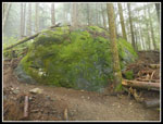 Big Mossy Rock |
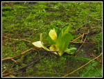 Skunk Cabbage |
 Quick Link Trail |
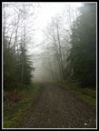 Very Cloudy |
 Tiger Lake |
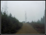 Towers In Sight |
 Many Bikers |
 Summit Again |
 Wide Open Forest |
 Jump & Bridge |
 Dark & Bright |
 More Skunk Cabbage |
 Coltsfoot |
 Yet Another Bridge |
 Biking Uphill |
 Yellow Violet |
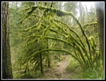 Mossy Arbor |
 Bleeding Hearts |
 Wet Trillium |
 Salmonberry Flowers |
 Devil's Club |
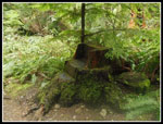 Stump Chair |
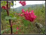 Red Currants |
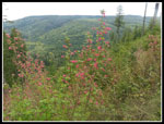 Red Currant Bushes |
 Creek From Bridge |
 More Mossy Arbors |
 Tiger Stripes |
 More Mossy Trees |
Trips - 2018
Home