4-15-18
Another
rainy morning after several straight weekends of rainy day. I had only
10 miles at the middle of the month. Time for a longer trip. Long trip,
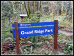
no snow, and away from the heavier rain in the mountains? Grand Ridge
sounded good. I reached the High Point trailhead at 8:10 am and was on
my way a few minutes later. It was off and on rain on the drive. There
was very light misty rain as I got started. Not enough to bother with
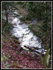
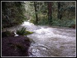
rain gear or my umbrella. The bridge at the start showed Issaquah Creek
was really running high. All that rain provided a lot of running water.
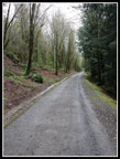
Shortly before leaving the railroad grade it was coverd with asphalt.
I'm not sure if it goes all the way to Issaquah. It was packed but not
fully. Bikes have put light tracks in places. There were four bikes at
the trail junction. As soon as I headed up the trail they followed and
passed me. That spot was the narrowest trail of the day. I saw bikes
off and on all day. Many of them were the same folks coming and going.
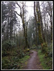
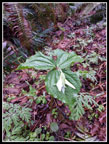
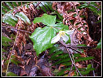
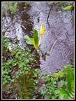
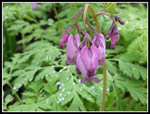
There are almost no creeks much of the year. In the winter and spring there can be a lot of them. Today I saw small creeks where I seldom if ever have seen them. With all the water, the trail was in great shape. Several of the muddiest sections have been worked on since last summer. The mud is now much less of a problem. With waterproof low top hiking shoes I had no problems and dry feet all day. I hoped to see trillium, bleeding hearts, and yellow violets along the lower trail. There are spring beauty here too but a bit later than this. I saw few wildflowers at first. I few trillium that had been blasted by the recent rain. They were difficult to photograph. I never did see any yellow violets. As i climbed I did see a couple blooming bleeding hearts. The first I have seen this year.s
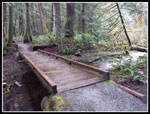
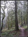
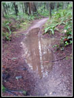
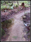
As the light rain stopped the trees kept dripping. It was hard to tel if it was still raining. Other than the wildflower photo stops I made good time. This is a fast hiking trail. I can usually average 3 mph over all the up and downhills. I crossed the paved road and then the two ends of the Water Tower Loop. At the low spot I found a skunk cabbage in the creek. Uphill again then down down down to the WTA Bridge. I often stop soon after but this day 9 miles was not enough. I passed the small erratic rock and stopped for photos again. The trail along here can hold water in the rainy season and that was the case this day. I could walk along the edges of these puddles/lakes. A few ups and downs and then the drop to the low spot at the Michael O Bridge.
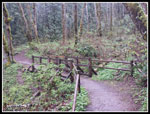
I often stop at this long boardwalk through a wetland. It makes for a 12 mile in and back trip. Not enough this day. After the boardwalk/bridge I climbed up to the far end of the trail at the Issaquah-Fall City Road. I have turned around here too. In order to round out my expected mileage and to see a new area I crossed the road and went about a quarter mile on the Duthie Hill trail. This is primarily for mountain bikes as is Grand Ridge.That extra bit would round my day up to 13 miles if I backtracked and 15 miles if I felt like adding the Water Tower Loop. I had a lunch break at the Grand Ridge trail start. There is a sign, a map, and a few benches. I was 6.75 miles into my day and it was still only 10:45 am.
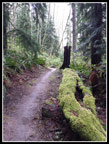
I dropped back to the Michael O Bridge. There was one spot along the wetland with skunk cabbage in bloom. Then came the climb back up and then down a bit to the WTA Bridge. On the way up I passed the largest bleeding heart patch of the day. Equal to all the others seen on the whole route. Another uphill section then down to the small creek with the one skunk cabbage. Then it was uphill once again. There are lots of gentle ups and downs but over 15 mile they still only added up to 2000' of elevation gain. When I reached the Water Tower Loop I decided to take it. The loop is 2.4 miles with a net gain of about 2 miles vs. the main trail. My feet were feeling it my now. I kept seeing bikes though with long breaks in between.
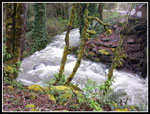
I was glad to finish the loop. It is not far from there to the paved road. Now I had just over two miles to go. I checked the Doppler radar and there was another wave of rain coming but I had a good chance to get back to my car before it arrived. The hike back to the railroad grade seemed slow but I was moving faster than it seemed. I was now running ahead of schedule. At one place along the grade there is a short trail down to Issaquah Creek. It was running so fast and loud than I could not resist heading down. A good spot to relax and enjoy the roaring creek. Not now though. A few photos and I was back on my way. I reached the parking lot at 1:53 pm. I was on the road right at 2:00 pm. It started raining as I drove into Issaquah. Very good timing.
I succeeded in having an almost entirely dry hike on a very wet weekend. The speedy trail allowed my to hike 15 miles and still be down before 2:00 pm. The drive home was fast as well at that time of day. I was pleased to see my first bleeding hearts of the year. There were trillium but the rain made them not very photogenic for now. All in all, it was a great day on the trail.
Click on thumbnails to get
larger pictures.
Trips - 2018
Home
There are almost no creeks much of the year. In the winter and spring there can be a lot of them. Today I saw small creeks where I seldom if ever have seen them. With all the water, the trail was in great shape. Several of the muddiest sections have been worked on since last summer. The mud is now much less of a problem. With waterproof low top hiking shoes I had no problems and dry feet all day. I hoped to see trillium, bleeding hearts, and yellow violets along the lower trail. There are spring beauty here too but a bit later than this. I saw few wildflowers at first. I few trillium that had been blasted by the recent rain. They were difficult to photograph. I never did see any yellow violets. As i climbed I did see a couple blooming bleeding hearts. The first I have seen this year.s
As the light rain stopped the trees kept dripping. It was hard to tel if it was still raining. Other than the wildflower photo stops I made good time. This is a fast hiking trail. I can usually average 3 mph over all the up and downhills. I crossed the paved road and then the two ends of the Water Tower Loop. At the low spot I found a skunk cabbage in the creek. Uphill again then down down down to the WTA Bridge. I often stop soon after but this day 9 miles was not enough. I passed the small erratic rock and stopped for photos again. The trail along here can hold water in the rainy season and that was the case this day. I could walk along the edges of these puddles/lakes. A few ups and downs and then the drop to the low spot at the Michael O Bridge.
I often stop at this long boardwalk through a wetland. It makes for a 12 mile in and back trip. Not enough this day. After the boardwalk/bridge I climbed up to the far end of the trail at the Issaquah-Fall City Road. I have turned around here too. In order to round out my expected mileage and to see a new area I crossed the road and went about a quarter mile on the Duthie Hill trail. This is primarily for mountain bikes as is Grand Ridge.That extra bit would round my day up to 13 miles if I backtracked and 15 miles if I felt like adding the Water Tower Loop. I had a lunch break at the Grand Ridge trail start. There is a sign, a map, and a few benches. I was 6.75 miles into my day and it was still only 10:45 am.
I dropped back to the Michael O Bridge. There was one spot along the wetland with skunk cabbage in bloom. Then came the climb back up and then down a bit to the WTA Bridge. On the way up I passed the largest bleeding heart patch of the day. Equal to all the others seen on the whole route. Another uphill section then down to the small creek with the one skunk cabbage. Then it was uphill once again. There are lots of gentle ups and downs but over 15 mile they still only added up to 2000' of elevation gain. When I reached the Water Tower Loop I decided to take it. The loop is 2.4 miles with a net gain of about 2 miles vs. the main trail. My feet were feeling it my now. I kept seeing bikes though with long breaks in between.
I was glad to finish the loop. It is not far from there to the paved road. Now I had just over two miles to go. I checked the Doppler radar and there was another wave of rain coming but I had a good chance to get back to my car before it arrived. The hike back to the railroad grade seemed slow but I was moving faster than it seemed. I was now running ahead of schedule. At one place along the grade there is a short trail down to Issaquah Creek. It was running so fast and loud than I could not resist heading down. A good spot to relax and enjoy the roaring creek. Not now though. A few photos and I was back on my way. I reached the parking lot at 1:53 pm. I was on the road right at 2:00 pm. It started raining as I drove into Issaquah. Very good timing.
I succeeded in having an almost entirely dry hike on a very wet weekend. The speedy trail allowed my to hike 15 miles and still be down before 2:00 pm. The drive home was fast as well at that time of day. I was pleased to see my first bleeding hearts of the year. There were trillium but the rain made them not very photogenic for now. All in all, it was a great day on the trail.
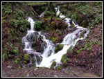 Trailside Falls |
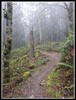 Misty Trail |
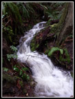 Beautiful Cascade |
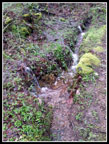 Water Water Everywhere |
 Dark But Drier Now |
 Soaking Wet Trillium |
 Bridge Near Road |
 Another Soaked Trillium |
 First Skunk Cabbage |
 Interesting Tree |
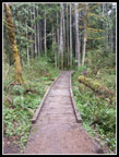
 Heading Downhill |
 Big Puddle |
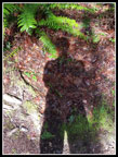 A Shadow! |
 Michael O Bridge |
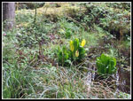 More Skunk Cabbage |
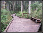 Break On The Bridge |
 East GR Trailhead |
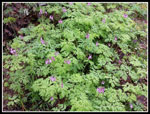 Bleeding Hearts Bleeding Hearts |
 Close Up Look |
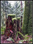 Colorful Stump |
 Overflowing |
 Green Border |
 Issaquah Creek Below |
 Along The Grade |
 Down By The Creek |
 Last Shot Of Creek |
Trips - 2018
Home