7/20-23/19
Gary,
John, and I had been trying
to fit in a backpacking trip for a few months. No date seemed to work
for all of us. the rest of summer was also not looking good. A four day
period suddenly appeared. Gary had done the Meadow Mountain trail from
the west some three decades earlier. Snow stopped them up on the ridge.
He had been back via the Whitechuck and Fire Creek Trails as well. I
did the full trail from Crystal then Meadow Lakes to the east end then
down Fire Creek and out the washed out Whitechuck Road in 2007 with Kim
Brown. Gary and I talked about this route for many years. The wash out
made it very difficult until recent times. John would be doing the
route for the first time. Meadow Mountain traverses a lot of very green
meadows high on the ridge. It is located west of Glacier Peak, north of
Lost Creek Ridge, and south of Lime Ridge. The Suiattle River is north
of Lime Ridge. My car had to go into the shop on Friday so we were left
with Saturday through Tuesday for the trip. The weather was cloudy with
some rain the week before. It improved markedly on Saturday.
Day 1
John and Gary picked me up in North Seattle at 7:05 am and we headed north. Up to Arlington, over to Darrington, then south to the Whitechuck River Road. The road now ends after the crossing of the river and only the road up to Rat Trap Pass remains. We drove that to the 2580' trailhead. There were already several cars in the small parking lot. We packed up and were on the trail at 9:07 am. The trail starts on an old closed logging road. If fact, the first 5.2 miles is on the old road. The original trail came up from the Whitechuck River. When the logging road went in it ended right at the trail. The lower trail has been lost. We began to gain elevation at once. A short way up John realized he had left his gps at the car. Back he went. Remarkably fast he caught up with Gary and I. From a 3000' high point the route begins to drop. It drops 300'. That is not so much fun near the end of the hike. At 1.50 miles we reached the junction with the road/trail to Crystal Lake. That is the route Kim and I took in 2007. The rest of the road and up to the Meadow Lake junction was all new trail to me.
The road/trail is actually in very good shape. It is wide in spots and much more trail like in others. It is not brushy at all at this time. We later met two guys who drove an ATV to the end of the road and they said their group is helping to maintain the route. We crossed over Crystal Creek which is in a big culvert. The brush there was dense enough to almost completely hide the creek though we could certainly hear it. The road is mostly in trees some 50 years after the logging. It mostly kept the heat at bay. There were some open spots where we had our first views out. Mt. Pugh and Sloan Peak were the first summits in sight. The road has some ups and downs but does not have a lot of elevation change. The road end elevation is about 3925'. That makes for a net gain of only about 1350' over those 5.2 miles.
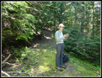
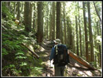
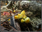
We took a break at the road end. As mentioned there was one ATV parked there. We then started up the old trail. It is gently graded with a series of fairly long switchbacks climbing in older forest. Now the way is dark and the ground cover minimal. We saw a number of saprophytes and mushrooms along here. There are several trees down. Most are easy enough to get over or under. One is just before a switchback and folks have cut a short trail to bypass. It would be great if the log could be cut out before the cut switchback route gets too well beat in. We gained about 1000' over the next 1.3 miles to the largest accessible creek seen so far. Plenty of water for drinking as of now.
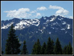
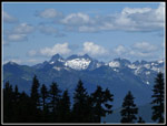
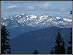
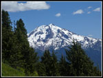
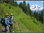
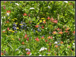
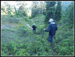
Now out of thick forest meadows began to show up. The main color of the trip was white. Lots of Valerian and bistort all along our route. some yellow too. Very little Indian paintbrush or lupine though both are a little in bloom. We also saw tiger lilies and columbine here and farther up the trail. Not crazy colors but still a pretty good wildflower show overall. We soon came to the junction with the side trail down to Meadow Lake. Now I was back on trail I had hiked in 2007. The route continued to climb with some more ups and downs. Not large downs but they added up over the course of the trip. Some times in forest and sometimes in the open with more views out to peaks. We had more and better looks south to Lost Creek Ridge. We met the two ATV guys heading down. We also passed a solo hiker going down. We took a break at a big meadow where a couple of backpackers passed us heading up. We also had first looks to Three Fingers Mountain, Mt. Baker, and Glacier Peak.
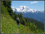
We kept climbing and reached a very large meadow. Now we had great views to the south and southwest. This would be a great place to camp except there is no water at all. One more steep climb to a ridge top and we were right above the basin of Owl Creek. This was our first night destination. We dropped 400' down to the basin and found one group in the best camping site. With all the rain the previous week much of the basin was "moist". We did find enough room for our three tents on dry ground. It was now 3:08 pm. We took 6 hours to hike 9.2 miles. Not a great speed but we had all day. We set up camp and quickly found that mosquitoes were going to be annoying for most of the trip.
After dinner we decided to do a little exploring. At the ridge top there was another trail going along the ridge top. Perhaps it went to a campsite and some views. We headed back up the 400' gain to the ridge top. On the way we met the couple who passed us at the meadow. They were camping on the ridge and coming down to get water. On the ridge we found their tent and a spot that once had a very good view. The trees have grown up and closed down much of the view. We did have a partly obstructed look at Glacier Peak.
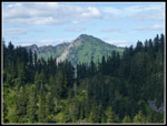
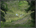
We dropped down to camp and decided on one more exploration. On the north side of the basin the slope climbs to a saddle. From the ridge we saw that though the ridge near the saddle is all forested the saddle itself had a narrow opening. We went cross country up the slope avoiding thick brush and down logs crossing over several grassy gullies to reach the saddle. It too was about a 400' climb. From the saddle we had a very good look at rocky and not very meadow like Meadow Mountain. It was not far away but did not look like an easy scramble. Below the saddle is Emerald Lake. We had not expected to see it on the trip. On the way back to camp we found a big meadow with running water Perhaps a campsite when the basin is full if the water is still running. When Kim and I passed through Owl Creek Basin in 2007 the creek was running on Labor Day.
We reached camp at 8:00 pm. An hour later was sunset and by 9:15 pm we were all in our tents. For the first day we hiked 11.0 miles with 4470' of elevation gain. The last 1.8 miles and 800' of gain were with day packs. The afternoon became quite warm and sunny. The skeeters were annoying. Overall, the first day was great hiking and set us up at 5440', high on Meadow Mountain's ridge.
Click on thumbnails to get
larger pictures.
Day 2
Trips - 2019
Home
Day 1
John and Gary picked me up in North Seattle at 7:05 am and we headed north. Up to Arlington, over to Darrington, then south to the Whitechuck River Road. The road now ends after the crossing of the river and only the road up to Rat Trap Pass remains. We drove that to the 2580' trailhead. There were already several cars in the small parking lot. We packed up and were on the trail at 9:07 am. The trail starts on an old closed logging road. If fact, the first 5.2 miles is on the old road. The original trail came up from the Whitechuck River. When the logging road went in it ended right at the trail. The lower trail has been lost. We began to gain elevation at once. A short way up John realized he had left his gps at the car. Back he went. Remarkably fast he caught up with Gary and I. From a 3000' high point the route begins to drop. It drops 300'. That is not so much fun near the end of the hike. At 1.50 miles we reached the junction with the road/trail to Crystal Lake. That is the route Kim and I took in 2007. The rest of the road and up to the Meadow Lake junction was all new trail to me.
The road/trail is actually in very good shape. It is wide in spots and much more trail like in others. It is not brushy at all at this time. We later met two guys who drove an ATV to the end of the road and they said their group is helping to maintain the route. We crossed over Crystal Creek which is in a big culvert. The brush there was dense enough to almost completely hide the creek though we could certainly hear it. The road is mostly in trees some 50 years after the logging. It mostly kept the heat at bay. There were some open spots where we had our first views out. Mt. Pugh and Sloan Peak were the first summits in sight. The road has some ups and downs but does not have a lot of elevation change. The road end elevation is about 3925'. That makes for a net gain of only about 1350' over those 5.2 miles.
We took a break at the road end. As mentioned there was one ATV parked there. We then started up the old trail. It is gently graded with a series of fairly long switchbacks climbing in older forest. Now the way is dark and the ground cover minimal. We saw a number of saprophytes and mushrooms along here. There are several trees down. Most are easy enough to get over or under. One is just before a switchback and folks have cut a short trail to bypass. It would be great if the log could be cut out before the cut switchback route gets too well beat in. We gained about 1000' over the next 1.3 miles to the largest accessible creek seen so far. Plenty of water for drinking as of now.
Now out of thick forest meadows began to show up. The main color of the trip was white. Lots of Valerian and bistort all along our route. some yellow too. Very little Indian paintbrush or lupine though both are a little in bloom. We also saw tiger lilies and columbine here and farther up the trail. Not crazy colors but still a pretty good wildflower show overall. We soon came to the junction with the side trail down to Meadow Lake. Now I was back on trail I had hiked in 2007. The route continued to climb with some more ups and downs. Not large downs but they added up over the course of the trip. Some times in forest and sometimes in the open with more views out to peaks. We had more and better looks south to Lost Creek Ridge. We met the two ATV guys heading down. We also passed a solo hiker going down. We took a break at a big meadow where a couple of backpackers passed us heading up. We also had first looks to Three Fingers Mountain, Mt. Baker, and Glacier Peak.
We kept climbing and reached a very large meadow. Now we had great views to the south and southwest. This would be a great place to camp except there is no water at all. One more steep climb to a ridge top and we were right above the basin of Owl Creek. This was our first night destination. We dropped 400' down to the basin and found one group in the best camping site. With all the rain the previous week much of the basin was "moist". We did find enough room for our three tents on dry ground. It was now 3:08 pm. We took 6 hours to hike 9.2 miles. Not a great speed but we had all day. We set up camp and quickly found that mosquitoes were going to be annoying for most of the trip.
After dinner we decided to do a little exploring. At the ridge top there was another trail going along the ridge top. Perhaps it went to a campsite and some views. We headed back up the 400' gain to the ridge top. On the way we met the couple who passed us at the meadow. They were camping on the ridge and coming down to get water. On the ridge we found their tent and a spot that once had a very good view. The trees have grown up and closed down much of the view. We did have a partly obstructed look at Glacier Peak.
We dropped down to camp and decided on one more exploration. On the north side of the basin the slope climbs to a saddle. From the ridge we saw that though the ridge near the saddle is all forested the saddle itself had a narrow opening. We went cross country up the slope avoiding thick brush and down logs crossing over several grassy gullies to reach the saddle. It too was about a 400' climb. From the saddle we had a very good look at rocky and not very meadow like Meadow Mountain. It was not far away but did not look like an easy scramble. Below the saddle is Emerald Lake. We had not expected to see it on the trip. On the way back to camp we found a big meadow with running water Perhaps a campsite when the basin is full if the water is still running. When Kim and I passed through Owl Creek Basin in 2007 the creek was running on Labor Day.
We reached camp at 8:00 pm. An hour later was sunset and by 9:15 pm we were all in our tents. For the first day we hiked 11.0 miles with 4470' of elevation gain. The last 1.8 miles and 800' of gain were with day packs. The afternoon became quite warm and sunny. The skeeters were annoying. Overall, the first day was great hiking and set us up at 5440', high on Meadow Mountain's ridge.
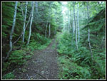 Old Road/Trail |
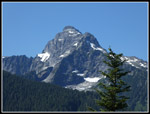 Mt. Pugh First View |
 Sloan Peak First View |
 Gary At End Of Road |
 On Old Trail |
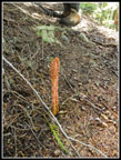 Saprophytes |
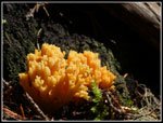 Fungus |
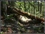 Big Logs Down |
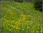 Wildflowers In Bloom |
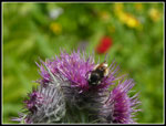 Bee On A Thistle |
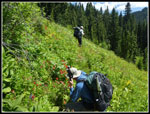 John At Work |
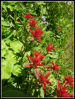 Indian Paintbrush |
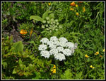 More Wildflowers |
 Lost Creek Ridge |
 Tiny Mushrooms |
 Snowy Peaks |
 More Snowy Peaks |
 Glacier Peak In View |
 John, Gary, & GP |
 Red Columbine |
 Guys & Glacier Peak |
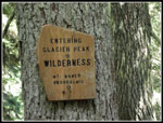 Wilderness Sign |
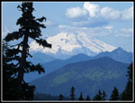 Mt. Baker |
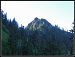
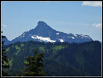 Whitechuck Mountain |
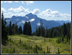 Meadow & Mt. Pugh |
 North Ridge Gap |
 Camp Is Below |
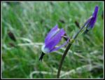 Shooting Stars |
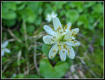 Marsh Marigold |
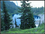 Emerald Lake |
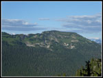
 Meadow Mountain |
 Lime Ridge |
 Heading Down |
 Shadows |
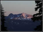 Alpenglow |
Day 2
Trips - 2019
Home