7-07-19
Gary,
John, and I were considering
a Sunday-Monday overnight trip up Ruby Mountain in the North Cascades.
Gary and I have planned a trip up Ruby about every other year for the
past several decades. Something always comes up. Usually it is bad
weather at the last minute or good weather and an inability to get a
camp site reservation for Fourth Of July Pass. This year it was bad
weather in the area. It is a trip with great views that requires clear
skies. As I backup we settled on a day trip up Mt. Aix on Sunday, the
last day of a four day Fourth of July weekend. West of the crest would
be in clouds with some rain. We decided to head across Chinook Pass to
the Bumping River Valley for Mt. Aix. Gary first hiked up from the east
side in 1974. My first visit was in 1990. I returned in 1991 and 1992
before Gary and I hiked it from the west side in 2002.
My last visit
was with Gwen in 2013.
It is amazing how few times we have been up such
a fun hike to a very high (7766') summit. Gary and I were also in the
area for a scramble up nearby Bismarck Peak in 2008.
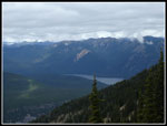
I was out the door at 5:55 am and met Gary at 6:30 in Kent. We picked up John and headed for Highway 410. Traffic was light and we made good time. It was totally overcast on the west side of the mountains. As we neared Chinook Pass we were engulfed in white with minimal visibility. Dropping down the east side we quickly dropped below the clouds. Onto the Bumping River Road to the end of pavement then 2.4 miles of rocky road and a left for another 1.5 miles of rocky road. Slow going but most any car can make it. We arrived at the trailhead at about 8:40 am. By 8:55 we were on our way. A later than usual start but it took 2:45 from my house to the trailhead. I have seldom seen more than 3 or 4 cars in the lot at the start. We found 8 on both sides of the road. We were prepared for a relatively large crowd.
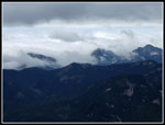
It was warmer than I expected but mostly overcast. The trail is just like I remembered it. A steady grade most of the way to the top of Nelson Ridge. No steps, few steep spots but just a long steady climb. There were a number of logs down in the first couple miles but none were a problem to get over. We saw a number of wildflowers along the route but no great flower gardens, at least so far. Some of the better flower displays were higher up. We got off to a fast start then settled down to a steady pace. We ended up having a lot more solitude than expected. We only passed four groups plus one hiker we started after us so many of the cars at the start must have been with other folks camped just beyond the lot. We were not disappointed. The forecast for 40% sky cover soon became clearly wrong. We did escape the rain on the west side and high winds farther north on the east side. We did not have much sky clearing. except for the summit. Mt. Rainier never did come out nor Adams either. We made doe with closer in mountain views.
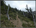
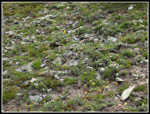
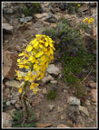
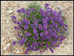
The climb to the ridge top junction with the Nelson Ridge Trail was 4.5 miles with 3400' of gain. At 7100' at the junction the air was noticeably thinner than at 200' early in the morning at home. Just before the 4 mile marker (the only marker) we met a couple who were descending from the summit. They were camped in a small meadow in sight of where we stopped for a break. They verified that there is only one small snow patch on the trail. They also mentioned the cold high winds on top. So far we had almost no wind. Well, we had lots of clothing including gloves and wool hats for the summer hike. The last part to the ridge top is more out in the open with a better wildflower display. Indian paintbrush, ballhead waterleaf, penstemon, and others added to the phlox and numerous yellow flowers seen everywhere.
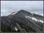
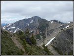
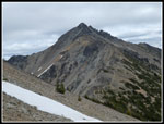
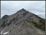
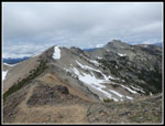
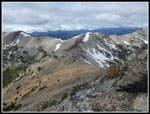
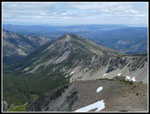
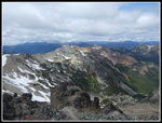
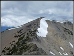
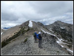
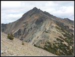
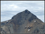
We turned right at the junction gaining a little more elevation on now bare rocky hillside just below the ridge top. When we turned the corner of the ridge we had our first look at Mt. Aix, the one snow patch, and were hit by the hardest and coldest wind of the day. We stopped to add more layers of clothing. I put on a jacket, gloves, and a wool hat. Summer in the Cascades. The peak still looked to be some distance away and very steep on all sides. Yes, it is. The route drops down to a low point then climbs more steeply towards the summit. Great views from here. Bismarck Peak is south along Nelson Ridge. Mt. Rainier should have dominated the view but was completely lost in the clouds along with everything else to the west. There wee some very colorful wildflowers along the route here.
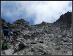
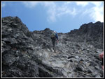
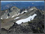
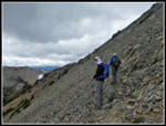
On all my previous visits until 2013 I followed the route under and beyond the summit on a very deteriorated trail on a steep hillside. The route climbs to the ridge top then drops down the north side. Snow holds here much later. It winds around and climbs to the summit. It is all on some degree of a trail. Much loose rock is found on the south side. In 2013 Gwen and I took a short cut straight up from under the summit. It climbs 300' in 1/8th of a mile. Very steep. There was no noticeable boot path before 2013. We had minimal difficulty following it then though ti was meager. This time we chose to take the short cut. The boot path is more obvious now down low. Higher up it requires a little route finding. We found our way up without getting off route.
We reached the summit at 12:40 pm. Not a great pace up but It was 5.6 miles up with about 4100' of gain. One weird thing did happen. A lone hiker passed us after crossing the snow patch. We watched him hike ahead on the trail. We saw him start up the scramble short cut. When we reached the top we expected to see him there. He was not there. I checked below on the north side and did not see him. I could see the entire trail down the north side and across and up to the ridge top. There was nobody in sight. When we returned there was one car there and a person who owned it. It will remain a mystery as to what happened.
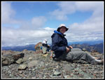
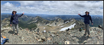
There was a little wind on top but nothing like we expected or we had at the snow patch. Just a cold but light breeze. Then the sky began to clear. It was still mostly white but some but blue patches provided some sunshine and a great deal of warmth. All in all, much better conditions than expected. What I figured would be a short stay turned into a long one. Over an hour. The peaks to the west were lost in clouds. Those far to the north were also. Most all the closer peaks were visible. many still had a little bit of snow to highlight them. Some really great views after all. We were also visited by Gary Double but you will have to check the photos to get that story. This was John's first visit ever and Gary's first in 17 years an I think they both really enjoyed it. We hung around on top until 145 p then packed up to head back.
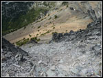
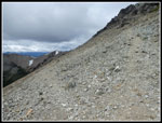
We debated descending the short cut or taking the half mile longer route down the north side, over the ridge, then back under the summit to the short cut spot. Since we had met the couple who did the longer route and did not mention any problems we chose to go that way. It had been 17 years since any of us had hiked that route. What could go wrong? The trail to the old summit lookout drops down easy enough and crossed where a big snowfield lays. Another trail from many years back goes around the snowfield. I would liked to have glissaded down the snow but it was too cool to do so in shorts. We did not want to stop to get out rain pants either. We went around the snow. good trail brought us up to the ridge top. The trail down was not as obvious as I expected. We hunted around a little and consulted Gary's GPS map to verify where to go. We dropped farther than I expected on a trail of loose small rocks. When we finally reached the junction with the trail that heads east we were sure we were on track.
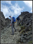
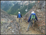
The trail under the summit is narrow and on loose dirt and rock in places. There is no exposure but its not a fun trail. We crossed the steep hillside slowly and were very glad to reach the short cut junction. Now we had pretty good trail all the way back. That long cut of .70 miles took us 45 minutes. On the summit we saw three people back at the snow patch. We did not pass anybody else while descending. The steady grade down made it seem easier than most 4000'+ descents. It is still a lot of descending. We reached the trailhead at 5:21 pm. Just the one before mentioned car in the lot.
The drive home was a little eerie for the Sunday of what was a four day holiday for many. Traffic was lighter than on must summer Sundays. No real slow downs to Kent and then on to Seattle. I was home before 8:30 pm. Perhaps the cloudy weather or just going on Highway 410 instead of I-90 or Highway 2 made a big difference. It was nice to not have holiday evening traffic to deal with. Each time I do this trip I marvel at the views and just how much fun it is. Then I wait five or ten years for the next visit. This is not an easy hike but it is well worth me returning at least every three or four years. A good time was had by all of us.
Click on thumbnails to get
larger pictures.
Trips - 2019
Home
I was out the door at 5:55 am and met Gary at 6:30 in Kent. We picked up John and headed for Highway 410. Traffic was light and we made good time. It was totally overcast on the west side of the mountains. As we neared Chinook Pass we were engulfed in white with minimal visibility. Dropping down the east side we quickly dropped below the clouds. Onto the Bumping River Road to the end of pavement then 2.4 miles of rocky road and a left for another 1.5 miles of rocky road. Slow going but most any car can make it. We arrived at the trailhead at about 8:40 am. By 8:55 we were on our way. A later than usual start but it took 2:45 from my house to the trailhead. I have seldom seen more than 3 or 4 cars in the lot at the start. We found 8 on both sides of the road. We were prepared for a relatively large crowd.
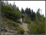
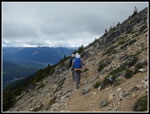
It was warmer than I expected but mostly overcast. The trail is just like I remembered it. A steady grade most of the way to the top of Nelson Ridge. No steps, few steep spots but just a long steady climb. There were a number of logs down in the first couple miles but none were a problem to get over. We saw a number of wildflowers along the route but no great flower gardens, at least so far. Some of the better flower displays were higher up. We got off to a fast start then settled down to a steady pace. We ended up having a lot more solitude than expected. We only passed four groups plus one hiker we started after us so many of the cars at the start must have been with other folks camped just beyond the lot. We were not disappointed. The forecast for 40% sky cover soon became clearly wrong. We did escape the rain on the west side and high winds farther north on the east side. We did not have much sky clearing. except for the summit. Mt. Rainier never did come out nor Adams either. We made doe with closer in mountain views.
The climb to the ridge top junction with the Nelson Ridge Trail was 4.5 miles with 3400' of gain. At 7100' at the junction the air was noticeably thinner than at 200' early in the morning at home. Just before the 4 mile marker (the only marker) we met a couple who were descending from the summit. They were camped in a small meadow in sight of where we stopped for a break. They verified that there is only one small snow patch on the trail. They also mentioned the cold high winds on top. So far we had almost no wind. Well, we had lots of clothing including gloves and wool hats for the summer hike. The last part to the ridge top is more out in the open with a better wildflower display. Indian paintbrush, ballhead waterleaf, penstemon, and others added to the phlox and numerous yellow flowers seen everywhere.
We turned right at the junction gaining a little more elevation on now bare rocky hillside just below the ridge top. When we turned the corner of the ridge we had our first look at Mt. Aix, the one snow patch, and were hit by the hardest and coldest wind of the day. We stopped to add more layers of clothing. I put on a jacket, gloves, and a wool hat. Summer in the Cascades. The peak still looked to be some distance away and very steep on all sides. Yes, it is. The route drops down to a low point then climbs more steeply towards the summit. Great views from here. Bismarck Peak is south along Nelson Ridge. Mt. Rainier should have dominated the view but was completely lost in the clouds along with everything else to the west. There wee some very colorful wildflowers along the route here.
On all my previous visits until 2013 I followed the route under and beyond the summit on a very deteriorated trail on a steep hillside. The route climbs to the ridge top then drops down the north side. Snow holds here much later. It winds around and climbs to the summit. It is all on some degree of a trail. Much loose rock is found on the south side. In 2013 Gwen and I took a short cut straight up from under the summit. It climbs 300' in 1/8th of a mile. Very steep. There was no noticeable boot path before 2013. We had minimal difficulty following it then though ti was meager. This time we chose to take the short cut. The boot path is more obvious now down low. Higher up it requires a little route finding. We found our way up without getting off route.
We reached the summit at 12:40 pm. Not a great pace up but It was 5.6 miles up with about 4100' of gain. One weird thing did happen. A lone hiker passed us after crossing the snow patch. We watched him hike ahead on the trail. We saw him start up the scramble short cut. When we reached the top we expected to see him there. He was not there. I checked below on the north side and did not see him. I could see the entire trail down the north side and across and up to the ridge top. There was nobody in sight. When we returned there was one car there and a person who owned it. It will remain a mystery as to what happened.
There was a little wind on top but nothing like we expected or we had at the snow patch. Just a cold but light breeze. Then the sky began to clear. It was still mostly white but some but blue patches provided some sunshine and a great deal of warmth. All in all, much better conditions than expected. What I figured would be a short stay turned into a long one. Over an hour. The peaks to the west were lost in clouds. Those far to the north were also. Most all the closer peaks were visible. many still had a little bit of snow to highlight them. Some really great views after all. We were also visited by Gary Double but you will have to check the photos to get that story. This was John's first visit ever and Gary's first in 17 years an I think they both really enjoyed it. We hung around on top until 145 p then packed up to head back.
We debated descending the short cut or taking the half mile longer route down the north side, over the ridge, then back under the summit to the short cut spot. Since we had met the couple who did the longer route and did not mention any problems we chose to go that way. It had been 17 years since any of us had hiked that route. What could go wrong? The trail to the old summit lookout drops down easy enough and crossed where a big snowfield lays. Another trail from many years back goes around the snowfield. I would liked to have glissaded down the snow but it was too cool to do so in shorts. We did not want to stop to get out rain pants either. We went around the snow. good trail brought us up to the ridge top. The trail down was not as obvious as I expected. We hunted around a little and consulted Gary's GPS map to verify where to go. We dropped farther than I expected on a trail of loose small rocks. When we finally reached the junction with the trail that heads east we were sure we were on track.
The trail under the summit is narrow and on loose dirt and rock in places. There is no exposure but its not a fun trail. We crossed the steep hillside slowly and were very glad to reach the short cut junction. Now we had pretty good trail all the way back. That long cut of .70 miles took us 45 minutes. On the summit we saw three people back at the snow patch. We did not pass anybody else while descending. The steady grade down made it seem easier than most 4000'+ descents. It is still a lot of descending. We reached the trailhead at 5:21 pm. Just the one before mentioned car in the lot.
The drive home was a little eerie for the Sunday of what was a four day holiday for many. Traffic was lighter than on must summer Sundays. No real slow downs to Kent and then on to Seattle. I was home before 8:30 pm. Perhaps the cloudy weather or just going on Highway 410 instead of I-90 or Highway 2 made a big difference. It was nice to not have holiday evening traffic to deal with. Each time I do this trip I marvel at the views and just how much fun it is. Then I wait five or ten years for the next visit. This is not an easy hike but it is well worth me returning at least every three or four years. A good time was had by all of us.
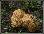 Big Fungus |
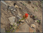 Indian Paintbrush |
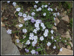 Phlox |
 John & Silver Snags |
 Thick Clouds |
 Bumping Lake |
 Smaller Trees Now |
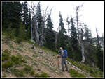
 Nelson Ridge Junction |
 Rock Garden |
 Pines & Firs |
 Wallflower |
 Looking South |
 Bismarck Peak |
 Snow & Mt. Aix |
 Mystery Hiker |
 More Color |
 Looking Back To Ridge |
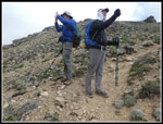 Photo Time |
 Great Color |
 Part Way Up Scramble |
 View From Near Top |
 Gary Surveys Route |
 Looking Down |
 Almost There |
 View Northeast |
 Our Route Down |
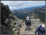
 Gary & John On Summit |
 View North |
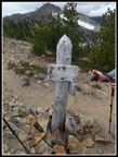
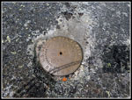 Benchmark |
 Starting Down |
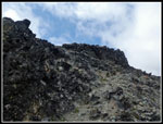 Summit Is Above |
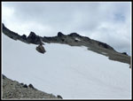 Big Snowfield |
 On Trail |
 Bright Flowers |
 Trail Junction |
 Traversing Under Summit |
 Back On Up Route |
 Ridge Top Views |
 Last Look At Aix |
 On Nelson Ridge |
 Us On The Summit |
 Presented by the Gary Westerlunds |
Trips - 2019
Home