7-24-21
This
has been a hot summer. First
the 110 degree heat in Seattle. Now the fires all over the east side of
the Cascade Mountains. Brush fires broke out along I90 in North Bend
and Cle Elum on Friday afternoon. So far the smoke was staying on the
east side. I wanted to get up high for views of the North Cascades but
did not want a long drive if the views did not happen. I ended up
deciding on a hike up Mt. Dickerman. So far this year I had only one
hike with 4000' of elevation gain or more. With a little extra distance
I could get 4000' on Dickerman. Hikes close to Puget Sound have been
over crowded since the pandemic began. I new I needed an early start. I
was on the road at 6:10 am and reached the parking lot along the
Mountain Loop Highway at 7:30 am. On the drive I noticed that the sky
was blue but the peaks were very hazy. I hoped for some views. The lot
was about half full. A dozen or so cars. There was one small bus taking
up about 5 spaces too.
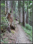
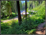
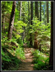
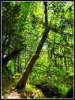
I planned to check out the trail to Perry Creek after hiking Dickerman. I have hiked the old Perry Creek Trail but not the newer one that starts in the Dickerman lot. I parked down at that end. The new outhouse there was open. the old outhouse at the Mt. Dickerman Trail end was closed and wrapped in plastic tape. I was on the trail at 7:35 am. The high temperature at trailhead elevation was forecast for near 80 degrees. When I started it was a slightly chilly 51 degrees. That did not last long. The trail starts at a moderate grade until reaching where the old trail came in. Then it is a steady steep grade for miles. Out of the valley bottom it warmed quickly and with all the effort I was plenty warm.
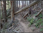
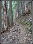
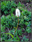
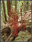
I passed a group of three early and then had solitude. Another big reason for the early start. On the way up I passed 10 or 11 groups. About half were going up and half coming down. Two guys camped on top overnight. I was quite surprised that nobody passed me going up. I was not moving all that fast but no fast hikers started even close to when I did. The many switchbacks fade one into another. The terrain is rocky in a lot of places. Not a smooth easy trail. On the other hand, there are few ups and downs. Just a steady uphill grade. I have been seeing a lot of saprophytes the past few weeks. The dark forest and minimal ground cover is perfect for them. On the way up I saw none. On the way down I did see several patches including a fresh group of them right along the edge of the trail. How did I miss that on the way up?
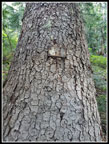
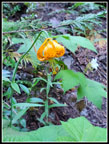
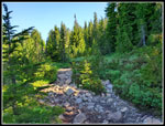
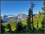
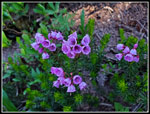
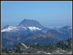
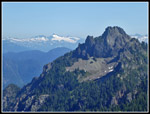
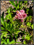
When I reached the short drop to a partial view of Big Four Mountain another group arrived just ahead of me and took that detour. I kept on climbing. I made a point of looking for the old metal 2 mile marker on a tree on the uphill side of the trail. It is just after the last switchback left as the trail begins a long traverse to the creek/waterfall. It was totally day this day. Much to my surprise I found the mile marker going up and down. It is the only one still standing. The 1 mile marker was on a tree that fell several decades ago. The trail finally comes out of the deep forest and there is a partial view of Big Four. There are summer wildflowers up here though not many were blooming now. Tiger lilies are seen right alongside the trail.
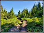
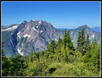
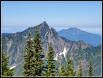
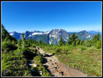
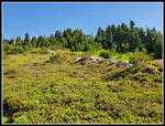
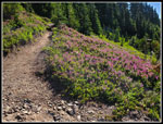
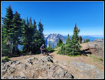
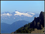
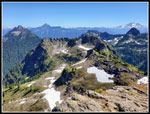
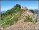
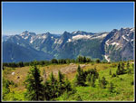
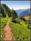
The trail crosses the dry creek/waterfall and switchbacks higher. Past the winter trail turnoff and then a short meadow, more forest, and into the bigger meadow. It was getting pretty warm in the open sunshine. The route climbs onto a ridge and I had some good views over to Stillaguamish Peak and Mount Forgotten. Finally I reached the big open meadow slopes leading up to the summit. The lack of people was nice but unusual on this popular hike. High up the heather was in full bloom. Lots of color. I finally reached the top at 9:58 am. 2:23 is not a great time but I'm starting to realize that my pace at age 50 is more than I can do now. I was happy to have hiked up at a steady rate with only some short photo stops. There were only a few groups on top. More would soon arrive and a steady stream came up and down while I was on top. Many did not stay very long.
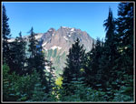
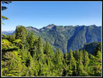
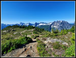
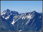
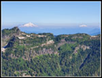
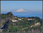
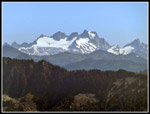
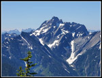
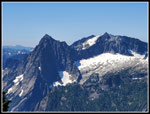
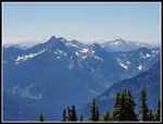
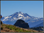
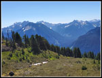
I mentioned that on my morning drive the peaks were very hazy. The good news is that it was pretty clear now. On the last climb up I had views south to Big Four, Vesper, Sperry, Morningstar, Del Campo, and the Monte Cristo Peaks. From the summit the views to the west, north, and east were outstanding. I have been using my phone camera for most hikes lately but I brought a super zoom point and shoot just for the summit. With it I could just make out the lookout atop Three Fingers. Mt Baker and Shuksan were brought in closer. I could pick out Mt. Pilchuck, Three Fingers, Whitehorse, Baker, Shuksan. Stillaguamish, Forgotten. El Dorado, Whitechuck, Dome, Glacier Peak, Pugh, Sloan, and more peaks. Mt. Dickerman is centered with no large peaks nearby to block the view. Though only 5,728' tall the views are among the best.
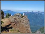
I sat down for a long summit stay. I met a couple from Florida who were ending their third week of four hiking Washington state. They were having a great time. I had a conversation with another group too. Since the pandemic started I have been avoiding busy trails and it was nice to hike an old favorite. Later I headed over to the other point a little to the east. It was 11:33 am when I packed up and headed down. Over an hour and a half on top and still descending well before noon. I slathered on a lot of sunscreen at the top. The bottom 2/3 is in dark forest but the upper meadows and summit allowed a lot of sunshine. I saw more folks on the trail during my descent but it was never crowded. So much the better. The knee pounding while dropping about 4000' was not pleasant. My knees are still not a big problem but I am noticing the big descents more as I age.
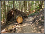
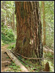
As mentioned I did find several patches of saprophytes on the descent. Most were extremely hard to focus on. The pale reddish color and darkness in the forest are a problem. One I have had before. The new patch right on the trail edge did focus easily. I had something to show for a few dozen photo attempts. I finally reached the trailhead at 1:46 pm. 2:13 to come down. Considering I took quite a few photos that was not too bad. Though it felt like 80 degrees in the parking lot and my body felt every bit of the 4000' of descent I chose to continue with my planned hike of the first part of the Perry Creek Trail. The forest is pretty thick and cool and there are some big trees along there. I met a few folks coming back too. I logged .95 miles to where the new trail reaches the old Perry Creek Road. The start of the road has been obliterated but the last part is now the route of the trail. I continued another .20 miles and stopped for food and water. My gps map was not working and as it turned out I was only .08 miles from the road end. Now I know.
I retraced my steps back to the parking lot. The lot had filled up with folks parked end to end around the edges. By now there were some empty spaces too. The drive back was not bad. Not like Highway 2 or I-90 on a weekend. I was home just before 5:00 pm. This was a great hike. Finally another 4000' gain day. The summit view was clearer than I feared and all the forest fire smoke stayed on the east side of the mountains. It was a very warm day but with an early start and the cool forest on the lower part of the hike it was not bad at all. A fun way to spend a mid summer weekend day.
Click on thumbnails to get
larger pictures.
Trips - 2021
Home
I planned to check out the trail to Perry Creek after hiking Dickerman. I have hiked the old Perry Creek Trail but not the newer one that starts in the Dickerman lot. I parked down at that end. The new outhouse there was open. the old outhouse at the Mt. Dickerman Trail end was closed and wrapped in plastic tape. I was on the trail at 7:35 am. The high temperature at trailhead elevation was forecast for near 80 degrees. When I started it was a slightly chilly 51 degrees. That did not last long. The trail starts at a moderate grade until reaching where the old trail came in. Then it is a steady steep grade for miles. Out of the valley bottom it warmed quickly and with all the effort I was plenty warm.
I passed a group of three early and then had solitude. Another big reason for the early start. On the way up I passed 10 or 11 groups. About half were going up and half coming down. Two guys camped on top overnight. I was quite surprised that nobody passed me going up. I was not moving all that fast but no fast hikers started even close to when I did. The many switchbacks fade one into another. The terrain is rocky in a lot of places. Not a smooth easy trail. On the other hand, there are few ups and downs. Just a steady uphill grade. I have been seeing a lot of saprophytes the past few weeks. The dark forest and minimal ground cover is perfect for them. On the way up I saw none. On the way down I did see several patches including a fresh group of them right along the edge of the trail. How did I miss that on the way up?
When I reached the short drop to a partial view of Big Four Mountain another group arrived just ahead of me and took that detour. I kept on climbing. I made a point of looking for the old metal 2 mile marker on a tree on the uphill side of the trail. It is just after the last switchback left as the trail begins a long traverse to the creek/waterfall. It was totally day this day. Much to my surprise I found the mile marker going up and down. It is the only one still standing. The 1 mile marker was on a tree that fell several decades ago. The trail finally comes out of the deep forest and there is a partial view of Big Four. There are summer wildflowers up here though not many were blooming now. Tiger lilies are seen right alongside the trail.
The trail crosses the dry creek/waterfall and switchbacks higher. Past the winter trail turnoff and then a short meadow, more forest, and into the bigger meadow. It was getting pretty warm in the open sunshine. The route climbs onto a ridge and I had some good views over to Stillaguamish Peak and Mount Forgotten. Finally I reached the big open meadow slopes leading up to the summit. The lack of people was nice but unusual on this popular hike. High up the heather was in full bloom. Lots of color. I finally reached the top at 9:58 am. 2:23 is not a great time but I'm starting to realize that my pace at age 50 is more than I can do now. I was happy to have hiked up at a steady rate with only some short photo stops. There were only a few groups on top. More would soon arrive and a steady stream came up and down while I was on top. Many did not stay very long.
I mentioned that on my morning drive the peaks were very hazy. The good news is that it was pretty clear now. On the last climb up I had views south to Big Four, Vesper, Sperry, Morningstar, Del Campo, and the Monte Cristo Peaks. From the summit the views to the west, north, and east were outstanding. I have been using my phone camera for most hikes lately but I brought a super zoom point and shoot just for the summit. With it I could just make out the lookout atop Three Fingers. Mt Baker and Shuksan were brought in closer. I could pick out Mt. Pilchuck, Three Fingers, Whitehorse, Baker, Shuksan. Stillaguamish, Forgotten. El Dorado, Whitechuck, Dome, Glacier Peak, Pugh, Sloan, and more peaks. Mt. Dickerman is centered with no large peaks nearby to block the view. Though only 5,728' tall the views are among the best.
I sat down for a long summit stay. I met a couple from Florida who were ending their third week of four hiking Washington state. They were having a great time. I had a conversation with another group too. Since the pandemic started I have been avoiding busy trails and it was nice to hike an old favorite. Later I headed over to the other point a little to the east. It was 11:33 am when I packed up and headed down. Over an hour and a half on top and still descending well before noon. I slathered on a lot of sunscreen at the top. The bottom 2/3 is in dark forest but the upper meadows and summit allowed a lot of sunshine. I saw more folks on the trail during my descent but it was never crowded. So much the better. The knee pounding while dropping about 4000' was not pleasant. My knees are still not a big problem but I am noticing the big descents more as I age.
As mentioned I did find several patches of saprophytes on the descent. Most were extremely hard to focus on. The pale reddish color and darkness in the forest are a problem. One I have had before. The new patch right on the trail edge did focus easily. I had something to show for a few dozen photo attempts. I finally reached the trailhead at 1:46 pm. 2:13 to come down. Considering I took quite a few photos that was not too bad. Though it felt like 80 degrees in the parking lot and my body felt every bit of the 4000' of descent I chose to continue with my planned hike of the first part of the Perry Creek Trail. The forest is pretty thick and cool and there are some big trees along there. I met a few folks coming back too. I logged .95 miles to where the new trail reaches the old Perry Creek Road. The start of the road has been obliterated but the last part is now the route of the trail. I continued another .20 miles and stopped for food and water. My gps map was not working and as it turned out I was only .08 miles from the road end. Now I know.
I retraced my steps back to the parking lot. The lot had filled up with folks parked end to end around the edges. By now there were some empty spaces too. The drive back was not bad. Not like Highway 2 or I-90 on a weekend. I was home just before 5:00 pm. This was a great hike. Finally another 4000' gain day. The summit view was clearer than I feared and all the forest fire smoke stayed on the east side of the mountains. It was a very warm day but with an early start and the cool forest on the lower part of the hike it was not bad at all. A fun way to spend a mid summer weekend day.
 Hikers Ahead |
 Log Over Trail |
 Rocky Trail |
 2 Mile Marker |
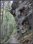 Overhanging Rock |
 First Views Out |
 Tiger Lily |
 Marsh Marigolds |
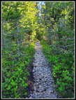 Rocks Are Trail |
 More Rocks |
 Nice Meadow |
 Stillaguamish Ridge |
 Peaks To The South |
 Big Four |
 Big 4 & Hall Peak |
 Hall & Pilchuck |
 Upper Meadows |
 Meadows Below |
 Looking Up |
 Heather In Bloom |
 Heather Flowers |
 Del Campo & Morningstar |
 Bistort |
 Lupine |
 Mt. Baker & Shuksan |
 Stillaguamish & Baker |
 Whitehorse Mountain |
 Next Arrival |
 Long Drop |
 Dome Peak |
 El Dorado Peak |
 Mt. Forgotten |
 Snow Below |
 Del Campo Peak |
 Sperry & Vesper |
 View Southeast |
 True Summit |
 Butterfly & Glacier |
 Heading Down |
 Indian Paintbrush |
 Monte Cristo Peaks |
 Meadow Hiking |
 Saprophytes |
 Back At Trailhead |
 Big Log Cut Out |
 Perry Creek Trail |
 Big Tree |
 Sunlight Through Trees |
Trips - 2021
Home