07-10-22
I
joined Gary and John for a hike
up Bandera Mountain. The beargrass display is often terrific and recent
trip reports showed it is nearing its peak. The road is closed on
weekdays this summer. The Annette Lake Trail is closed for the summer.
The Snow Lake Trail will be closed as of next weekend. Weekends at
Mason Lake/Bandera Mountain will be packed all summer. Especially now
with the beargrass in full bloom. We had a plan. We met at Eastgate at
7:00 am. We were parked off Exit 42 at about 7:25 am. This was already
too late to get a parking space in the Ira Spring Trail lot. There were
7 or 8 cars parked at Exit 42. We all knew about this route but had not
been on it. It adds about .70 miles including walking the road a short
way. It adds over 500' of gain. It is a steep route and not a
maintained trail. The day was clear as we started at 7:30 am.
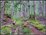
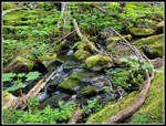
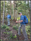
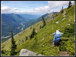
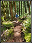
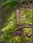
It was very humid in the forest. The route follows Mason Creek. Though it was still cool, I was sweating profusely by the time we reached the road. We were not surprised to find the lot almost full and cars parked along the road as far as we could see. It was just 7:51 am. Before starting up the trail, I stopped to zip off my pants legs and switched into a short sleeve shirt. That helped a lot. The hike up the road/trail was much gentler than the first climb. After a steady ascent, we turned off on the Old Mason Lake Trail. At first, it is nice smooth switchbacks before it becomes a steep climb up a narrow route. We saw a lot of a pink saprophyte in the forest. There is little ground cover. The route does climb alongside Mason Creek. That is pretty scenic. Our pace slowed way down on this section of the trail. Very little of the trail is smooth.
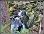
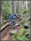
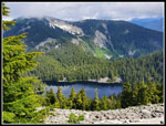
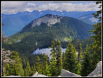
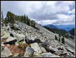
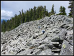
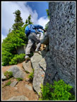
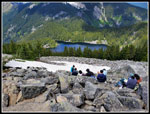
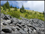
We took a break where we crossed the creek at the base of the big boulder field. The route gets a bit more challenging from here up. Now it is rocky as it climbs the side of the boulder field. After a switchback, the route gets steeper as it climbs above the boulders. Finally, the grade eases as we neared the Ira Spring Trail once again. We had total solitude for the first and third sections. The part on the Ira Spring Trail lower down included seeing other hikers. The short distance to Mason Lake had us passing groups going up and down. We took a short break at the lake for photos and some food and water. We were back on our way at 9:37 am. We had hiked about 3.2 miles with 2700' of elevation gain. Heading back on the Ira Spring Trail we continuously met folks hiking in. An awful lot of hikers were at Mason Lake this day.
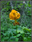
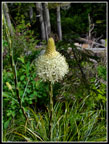
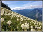
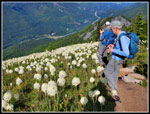
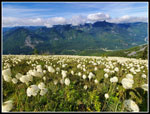
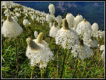
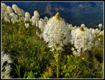
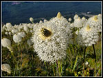
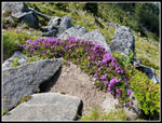
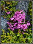
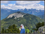
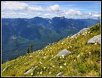
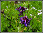
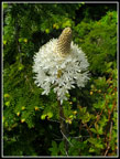
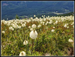
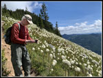
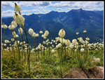
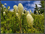
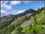
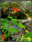
Next, we headed up Bandera Mountain. Our route was a bit easier than the main trail/steep gully route. Near the ridge top, we reached a sea of beargrass. I have been up there at peak on really good years for beargrass and this one rated near the best. Thousands of densely packed beargrass filled the open slopes. It is a pretty impressive sight. We made very slow progress on the short distance to the ridge top. We did not expect to be and were not alone most anywhere high on the mountain. It is a little early for most of the other wildflowers. We did see some phlox, penstemon, lupine, and heather but not a lot is in bloom yet. Down on the trail above the parking, lot we saw lots of twinflower and starflower plus the first tiger lilies I have seen this year.
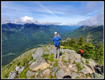
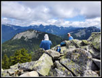
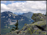
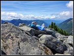
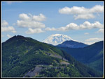
We climbed up to just below the false summit and stopped with a view down to Mason Lake and across to Mt. Defiance. Defiance was now in clouds. We still had mostly blue sky but some clouds had blown in. Mt. Rainier was completely lost in the clouds. We sat on some rocks just below the trail and took a break. We had great views out towards Kaleetan Peak. On the morning drive, we debated going on to the real summit. There was still some snow below us on the north side and we were unsure if the route to the real summit would be snow-free. In places, it side hills a steep slope. We had light boots and no traction devices. We decided to give it a shot. I had done it twice. The last time was with Gary in 2009. The route was challenging to follow back then. It now shows up on phone GPS maps. Perhaps it was much clearer now.
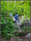
At the false summit, there was a crowd. We could not get to the narrow trail heading down the other side. One group did start down the trail. A few minutes later we followed them. They were now out of sight and we did not see them again until the real summit. We started at 10:46 am. The route starts pretty nice. Easy to follow at first. It follows the ridge at or below on the south side. At one point we crossed over the ridge to the north side and were quickly on snow. On my previous trips, I stayed on the south side completely. Rather than side hill on snow with light hiking shoes, we chose to backtrack to the ridge top. We pushed through some trees and back onto more open slopes. Here it was more like I recalled. A minimal trail that was not much better than animal trails. It soon settled down to a more obvious trail again. The snow route climbed back up the ridge and merged with our route. The route makes an almost 90 degree turn in the forest. We did have some snow here but it was not a problem. I was glad to reach the start of the big boulder fields.
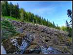
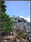
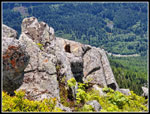
The last part crosses a big boulder field. It was snow-free. We dropped down and crossed to a line of big evergreen trees. Once past that we were near the summit. The summit is just a big pile of rocks at the top of the boulder field. We could hear voices before we could see them. There were 6 hikers on top when we arrived at 11:34 am. With a little route finding and photo stops, it took us 48 minutes from the false summit to the real one. On the way back we cut this down to 37 minutes. For all the ups and downs on our route, we gained a net of only 84'. The false summit is 5147' and the real one is 5241'.
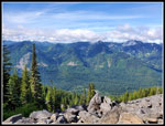
The views are really good. While Rainier was still mostly in the clouds, we could clearly see Mt. Adams. The Granite Mountain lookout was visible. To the left of it, we could see Mt. Stuart. Pratt Mountain sat just across the valley. Island Lake was just below with Rainbow Lake beyond it. Mt. Defiance was still in the clouds. The two groups on top when we arrived left. They were replaced by several more. Another group arrived when we started down. On my previous visits, I saw nobody beyond the false summit. Main Bandera Mountain has been discovered. Not nearly as busy as the false summit but no longer unknown.
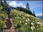
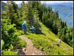
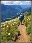
We spent 1:13 on top. At 12:47 pm we started down. With less elevation gain and no route-finding difficulties, we were back at the false summit at 1:24 pm. It was still early in the day though we had been on the trail for 5:54. We dropped down for a break a little slower than our break coming up. The rocks on and below the ridge were full of other people. Laying on the rocks in the sunshine with views all around we were not in a big hurry to move on. We stopped at 1:30 pm We packed up to leave at 2:17 pm. Chalk up another 47 minutes sitting near the mountain top. On the ridge down we stopped for more flower shots. Mt. Rainier was now half out of the clouds. Mt. Defiance was in the clear. We scrambled down the steep parts and stopped near the top of the big beargrass slopes. Many more photos were taken. Once we started moving again we set a moderate but consistent pace. Down to the Ira Spring Trail. we hiked. From there we had views up the beargrass covered slopes. Then we started the long but well-graded trail down the mountain.
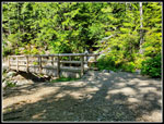
We saw the expected crowds on the Ira Spring Trail. Some still coming up and more heading down. Fast folks zipped on by and we passed the slower hikers. We took one last break at the bridge over Mason Creek. John filtered some water while Gary and I sat in the shade. When we reached the parking lot we found it was still mostly full. It was now 4:28 pm. We hiked through the lot and found the op of our last trail section. Cars were still parked all along the road. On every other trip up these trails we were done at the parking lot. Now, after 4100' of elevation gain and 3550' of loss, we still had a steep half-mile to go. The tread is soft and that helped a lot. It took us 21 minutes to come down. We arrived at the car at 4:54 pm.
For the day we hiked 9.7 miles with 4100' of elevation gain. This was my first 4000' hike of the year. Usually, I have 2-5 by now. It was a long day but with a short drive and early start I was home just after 6:00 pm, We spent over 3 hours sitting and enjoying the sunshine and views high on the mountain. Our route choice provided a lot of solitude in a very busy area. We did have crowds in places but not for most of the day. Nobody who hiked to Mason Lake from the main lot on the Ira Spring Trail could make that claim. It was near 80 degrees back at the car though it was much cooler up high. We set out to try a new trail, see a lake, and enjoy the beargrass display. We did all that and visited a second summit as well. This proved to be a very nice day on a hike not that far from Seattle.
Click on thumbnails to get
larger pictures.
Trips - 2022
Home
It was very humid in the forest. The route follows Mason Creek. Though it was still cool, I was sweating profusely by the time we reached the road. We were not surprised to find the lot almost full and cars parked along the road as far as we could see. It was just 7:51 am. Before starting up the trail, I stopped to zip off my pants legs and switched into a short sleeve shirt. That helped a lot. The hike up the road/trail was much gentler than the first climb. After a steady ascent, we turned off on the Old Mason Lake Trail. At first, it is nice smooth switchbacks before it becomes a steep climb up a narrow route. We saw a lot of a pink saprophyte in the forest. There is little ground cover. The route does climb alongside Mason Creek. That is pretty scenic. Our pace slowed way down on this section of the trail. Very little of the trail is smooth.
We took a break where we crossed the creek at the base of the big boulder field. The route gets a bit more challenging from here up. Now it is rocky as it climbs the side of the boulder field. After a switchback, the route gets steeper as it climbs above the boulders. Finally, the grade eases as we neared the Ira Spring Trail once again. We had total solitude for the first and third sections. The part on the Ira Spring Trail lower down included seeing other hikers. The short distance to Mason Lake had us passing groups going up and down. We took a short break at the lake for photos and some food and water. We were back on our way at 9:37 am. We had hiked about 3.2 miles with 2700' of elevation gain. Heading back on the Ira Spring Trail we continuously met folks hiking in. An awful lot of hikers were at Mason Lake this day.
Next, we headed up Bandera Mountain. Our route was a bit easier than the main trail/steep gully route. Near the ridge top, we reached a sea of beargrass. I have been up there at peak on really good years for beargrass and this one rated near the best. Thousands of densely packed beargrass filled the open slopes. It is a pretty impressive sight. We made very slow progress on the short distance to the ridge top. We did not expect to be and were not alone most anywhere high on the mountain. It is a little early for most of the other wildflowers. We did see some phlox, penstemon, lupine, and heather but not a lot is in bloom yet. Down on the trail above the parking, lot we saw lots of twinflower and starflower plus the first tiger lilies I have seen this year.
We climbed up to just below the false summit and stopped with a view down to Mason Lake and across to Mt. Defiance. Defiance was now in clouds. We still had mostly blue sky but some clouds had blown in. Mt. Rainier was completely lost in the clouds. We sat on some rocks just below the trail and took a break. We had great views out towards Kaleetan Peak. On the morning drive, we debated going on to the real summit. There was still some snow below us on the north side and we were unsure if the route to the real summit would be snow-free. In places, it side hills a steep slope. We had light boots and no traction devices. We decided to give it a shot. I had done it twice. The last time was with Gary in 2009. The route was challenging to follow back then. It now shows up on phone GPS maps. Perhaps it was much clearer now.
At the false summit, there was a crowd. We could not get to the narrow trail heading down the other side. One group did start down the trail. A few minutes later we followed them. They were now out of sight and we did not see them again until the real summit. We started at 10:46 am. The route starts pretty nice. Easy to follow at first. It follows the ridge at or below on the south side. At one point we crossed over the ridge to the north side and were quickly on snow. On my previous trips, I stayed on the south side completely. Rather than side hill on snow with light hiking shoes, we chose to backtrack to the ridge top. We pushed through some trees and back onto more open slopes. Here it was more like I recalled. A minimal trail that was not much better than animal trails. It soon settled down to a more obvious trail again. The snow route climbed back up the ridge and merged with our route. The route makes an almost 90 degree turn in the forest. We did have some snow here but it was not a problem. I was glad to reach the start of the big boulder fields.
The last part crosses a big boulder field. It was snow-free. We dropped down and crossed to a line of big evergreen trees. Once past that we were near the summit. The summit is just a big pile of rocks at the top of the boulder field. We could hear voices before we could see them. There were 6 hikers on top when we arrived at 11:34 am. With a little route finding and photo stops, it took us 48 minutes from the false summit to the real one. On the way back we cut this down to 37 minutes. For all the ups and downs on our route, we gained a net of only 84'. The false summit is 5147' and the real one is 5241'.
The views are really good. While Rainier was still mostly in the clouds, we could clearly see Mt. Adams. The Granite Mountain lookout was visible. To the left of it, we could see Mt. Stuart. Pratt Mountain sat just across the valley. Island Lake was just below with Rainbow Lake beyond it. Mt. Defiance was still in the clouds. The two groups on top when we arrived left. They were replaced by several more. Another group arrived when we started down. On my previous visits, I saw nobody beyond the false summit. Main Bandera Mountain has been discovered. Not nearly as busy as the false summit but no longer unknown.
We spent 1:13 on top. At 12:47 pm we started down. With less elevation gain and no route-finding difficulties, we were back at the false summit at 1:24 pm. It was still early in the day though we had been on the trail for 5:54. We dropped down for a break a little slower than our break coming up. The rocks on and below the ridge were full of other people. Laying on the rocks in the sunshine with views all around we were not in a big hurry to move on. We stopped at 1:30 pm We packed up to leave at 2:17 pm. Chalk up another 47 minutes sitting near the mountain top. On the ridge down we stopped for more flower shots. Mt. Rainier was now half out of the clouds. Mt. Defiance was in the clear. We scrambled down the steep parts and stopped near the top of the big beargrass slopes. Many more photos were taken. Once we started moving again we set a moderate but consistent pace. Down to the Ira Spring Trail. we hiked. From there we had views up the beargrass covered slopes. Then we started the long but well-graded trail down the mountain.
We saw the expected crowds on the Ira Spring Trail. Some still coming up and more heading down. Fast folks zipped on by and we passed the slower hikers. We took one last break at the bridge over Mason Creek. John filtered some water while Gary and I sat in the shade. When we reached the parking lot we found it was still mostly full. It was now 4:28 pm. We hiked through the lot and found the op of our last trail section. Cars were still parked all along the road. On every other trip up these trails we were done at the parking lot. Now, after 4100' of elevation gain and 3550' of loss, we still had a steep half-mile to go. The tread is soft and that helped a lot. It took us 21 minutes to come down. We arrived at the car at 4:54 pm.
For the day we hiked 9.7 miles with 4100' of elevation gain. This was my first 4000' hike of the year. Usually, I have 2-5 by now. It was a long day but with a short drive and early start I was home just after 6:00 pm, We spent over 3 hours sitting and enjoying the sunshine and views high on the mountain. Our route choice provided a lot of solitude in a very busy area. We did have crowds in places but not for most of the day. Nobody who hiked to Mason Lake from the main lot on the Ira Spring Trail could make that claim. It was near 80 degrees back at the car though it was much cooler up high. We set out to try a new trail, see a lake, and enjoy the beargrass display. We did all that and visited a second summit as well. This proved to be a very nice day on a hike not that far from Seattle.
 Lower Mason Ck Trail |
 Tiger Lily |
 Cascading Creek |
 Old Mason Lake Trail |
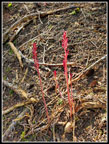 Saprophyte |
 Mossy Green |
 Big Boulder Field |
 On Trail |
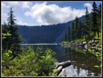 Mason Lake Shore |
 First Beargrass |
 View South |
 Gary & John |
 Beargrass Bonanza |
 Guys & Beargrass |
 All The Way Down |
 Closer Look |
 Even Closer |
 Closer Still |
 Brightly Lit Up |
 John On Ridge Top |
 Penstemon |
 Heather |
 Mason Lake |
 Heading On |
 Pratt Mt & Island Lake |
 Boulder Field Ahead |
 Guys Crossing Field |
 Guys On Real Summit |
 Granite Mt. Lookout |
 John & Pratt Mt. |
 Heading Down |
 Back To Open Slope |
 Boot Path |
 Scramble Up |
 Hikers Below Ridge |
 Penstemon? |
 Gary Relaxes |
 Marmot |
 Back To Beargrass |
 Different Later Lighting |
 Jim At Work |
 Beargrass Lined Trail |
 Lower Perspective |
 From Ira Spring Trail |
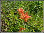 Indian Paintbrush |
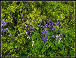 Lupine |
 PPP & Mt. Defiance |
 Upper Slopes |
 Mt. Rainier |
 Bridge |
 Columbine |
 Final Stretch |
 Another Saprophyte |
Trips - 2022
Home