02-12-22
It
looked like another clear weekend day. I missed the previous weekend as
I was out of state attending my brother's wedding. I now had only 3
weeks left in February. I started my hiking month on Tuesday with a
headlamp hike after work. Now I needed two weekend trips. The loop on
Chuckanut Mountain was snow free and would allow me to get in 11 miles
with 2700' of gain. I wanted to get an early start. I was on the road
at 7:00 am heading north to Bellingham. I arrived at the North
Chuckanut Trailhead at 8:20 am. The spot forecast projected a
temperature of 37 degrees. It was 30 degrees. A little colder than
expected. The lot was about half full. I started up the trail at a good
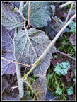
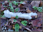
pace trying to warm up. I was stopped almost immediately by a number of
bright
white hair ice covered sticks. This is a rare event for me and I made
sure I had a few photos that were well focused. The grade turns flat
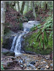
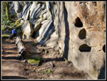
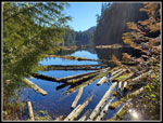
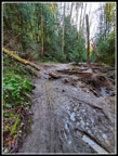
after turning onto the Interurban Trail. I came to a sign stating the
trail was washed out ahead. There is a detour around it. I had to see
how
bad the washout was. The answer is not bad if it is not raining. The
neat waterfall is what washed out. The bridge is no more and there is
some mud. It was easy to cross since it has not rained in a week or so.
I crossed with no problems.
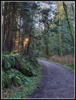
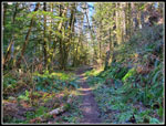
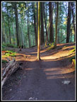
Soon the trail gets down to business gaining elevation. I used to hike straight over to the Arroyo Park entrance and then start climbing. Now the route turns uphill sooner on a switchbacking trail. It is wide and perfect for bicycles to zoom down. This morning I saw a few runners and one hiker coming down then two hikers going up in the first 2.2 miles. It was pretty quiet. As I gained elevation the temperature rose quickly. It must have gone up ten degrees by the time I had gained 500'. There are many trail junction on Chuckanut Mountain. Most of them have signs. At major junction there is a big map with "you are here" shown. Still, it is a good idea to have a map or better yet, a gps that shows your current location. The two hikers who passed me did so just before the 2.2 mile mark where the Chuckanut Ridge Trail begins with a sharp right turn.
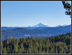
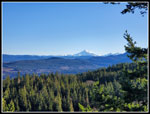
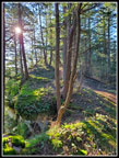
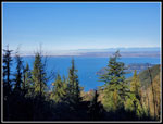
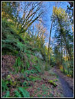
Above is a steep hillside. The trail traverses below then climbs steeply up the ridge to the top. This quick climb leaves you atop a narrow ridge. It drops steeply on both sides. To the right is saltwater barely seen through the forest. To the left is Mt. Baker. There are several spots with openings and views of Baker. Among the best are near the start of the ridge. I stopped for photos as the early morning light was very good. Farther north I could see a little of Bellingham. The ridge is 3.1 miles long up to the highest point near the Cyrus Gates Overlook. I was hiking 5.3 miles to the Overlook, though one can drive there. My return route was in the valley just left of the ridge. I mean just left and way below the ridge. That would be in shade but I had a few bits of sunshine on the ridge.
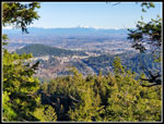
The ridge is not flat. There are many ups and downs. This hike starts at about 100' above sea level and climbs to 1920' at the highest point. All the ups and down bring the elevation gain up to 2700'. The ridge always takes me longer than I expect. At .80 miles along the ridge is a trail dropping down to Cleator Road. A few years ago Janet and I hiked the ridge in the opposite direction then took this trail down to the road and back to the cars at the Two Dollar Trailhead. Along the ridge I was passed by a number of runners going in the opposite direction. I also saw one biker near the start. The ridge is used but never crowded. Near the end of the ridge it reaches Cleator Road just before the Overlook. I usually take the road the last bit. This day I decided to stay on the ridge to the top of Middle Chuckanut Mountain. I gets very steep in one spot. I was rewarded at the top with a small spot out of the forest and sitting in bright sunlight. It was much warmer in the sunshine. I took advantage and had my brunch here. I arrived at 11:08 am. I stayed until 11:20 am. It only took me few minutes to drop down to Cyrus Gates Overlook. When I arrived every parking space was full. There were 4 or 5 motorbikes and a number of mountain bikes. A few minutes later it was quiet with the bikes all gone.
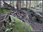
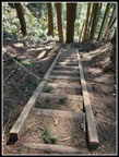
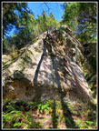
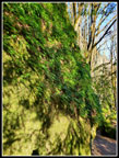
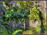
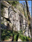
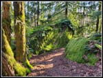
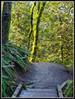
I took a few photos, used the outhouse, and I was on my way again. The fun begins here. The ridge is a fun hike but the Rock Trail is my favorite. A trail enters forest and I quickly reached the top of the Rock Trail. At first it loses a lot of elevation descending on steps. The slope is crazy steep and the steps/ladders are a way to make it hikeable. At the bottom, the trail crosses the steep slope. In one place the rock overhangs the trail. The rock is sandstone which is not often seen in Washington State. That is one neat feature of the route. I have hiked this trail in spring with wildflowers and skunk cabbage lower down. In fall there are some colorful leaves. In winter the deciduous trees are all bare making for one more different appearance. The trail was not too busy this day as I passes just a few other groups. It is only 1.2 miles to the bottom. I expect to take at least on hour to hike it. There is much to see and speed is not helpful.
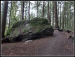
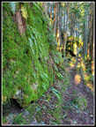
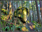
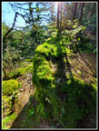
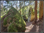
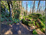
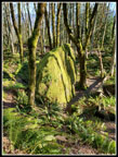
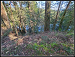
The low sunshine really lit up the mossy rocks seen along the way. Some of the rocks are quite large. The rocks also have many ferns growing on them. Every season provides a different look along the trail. At the bottom I turned left heading for Lost Lake. The trail is pretty flat as it heads back under the ridge I hike up in the morning. It was a bit muddy too but only in a few places. I could soon see Lost Lake below me through the trees. Once beyond the lake I came to a junction. I turned right and headed towards the lake. Rather than cross several muddy sections I headed right and towards the lake. This is much less wet. The only trick is getting out of the forest when the lake is high in winter. I tried one spot and it was marshy. My next try went better. I could now see down the lake. It is long and narrow. This spot was now back in the sunshine. It was much warmer than in the forest. I would not have much sunshine on the way back.
I stayed a short while and then headed back. There was a big group at the trail junction. I turned right and they did not follow. I had quite a bit of solitude on the way back. The trail drops then climbs then is flat. It passes one nice waterfall. In places there are vertical sandstone walls along the trail. The ridge I hiked in on is nearly vertical above. The sunshine seldom was on me but it did light up the trees above. I had some interesting photo opportunities. I completed my loop where the Chuckanut Ridge Trail started. Now I just had 2.2 miles to retrace. My plantar fasciitis is getting better. I hiked over 7 miles before my right heel began to hurt. That still left 4 miles to go. The last mile was not much fun. Not fully better but much improved over a few months ago. Having several old road sections did not help. Plantar hurts the worst on hard surfaces.
I reached the parking lot at 2:20 pm. I took 5:55 to hike 11 miles with 2700' of elevation gain. As I dropped to the trailhead the temperature began to drop as well. It was colder than higher up the trail but much warmer than my sub freezing start in the morning. This has become a favorite route for me. It is snow free much of the winter. I always see other folks but it is not nearly as crowded as nearby Oyster Dome. The ridge trail is fun with its ups and downs and views of Baker on a clear day. The Rock Trail is one of a kind. Throw in a lake and miles of easy walking on the way back. I had no traffic problems this day as I returned home at 4:15 pm including a stop for gas. There was a slow down near Marysville but not nearly as bad as northbound. It was nice to do a February hike with no snow and sunshine that included 2700' of gain. All in all, it was a great day on the trail.
Click on thumbnails to get
larger pictures.
Trips - 2022
Home
Soon the trail gets down to business gaining elevation. I used to hike straight over to the Arroyo Park entrance and then start climbing. Now the route turns uphill sooner on a switchbacking trail. It is wide and perfect for bicycles to zoom down. This morning I saw a few runners and one hiker coming down then two hikers going up in the first 2.2 miles. It was pretty quiet. As I gained elevation the temperature rose quickly. It must have gone up ten degrees by the time I had gained 500'. There are many trail junction on Chuckanut Mountain. Most of them have signs. At major junction there is a big map with "you are here" shown. Still, it is a good idea to have a map or better yet, a gps that shows your current location. The two hikers who passed me did so just before the 2.2 mile mark where the Chuckanut Ridge Trail begins with a sharp right turn.
Above is a steep hillside. The trail traverses below then climbs steeply up the ridge to the top. This quick climb leaves you atop a narrow ridge. It drops steeply on both sides. To the right is saltwater barely seen through the forest. To the left is Mt. Baker. There are several spots with openings and views of Baker. Among the best are near the start of the ridge. I stopped for photos as the early morning light was very good. Farther north I could see a little of Bellingham. The ridge is 3.1 miles long up to the highest point near the Cyrus Gates Overlook. I was hiking 5.3 miles to the Overlook, though one can drive there. My return route was in the valley just left of the ridge. I mean just left and way below the ridge. That would be in shade but I had a few bits of sunshine on the ridge.
The ridge is not flat. There are many ups and downs. This hike starts at about 100' above sea level and climbs to 1920' at the highest point. All the ups and down bring the elevation gain up to 2700'. The ridge always takes me longer than I expect. At .80 miles along the ridge is a trail dropping down to Cleator Road. A few years ago Janet and I hiked the ridge in the opposite direction then took this trail down to the road and back to the cars at the Two Dollar Trailhead. Along the ridge I was passed by a number of runners going in the opposite direction. I also saw one biker near the start. The ridge is used but never crowded. Near the end of the ridge it reaches Cleator Road just before the Overlook. I usually take the road the last bit. This day I decided to stay on the ridge to the top of Middle Chuckanut Mountain. I gets very steep in one spot. I was rewarded at the top with a small spot out of the forest and sitting in bright sunlight. It was much warmer in the sunshine. I took advantage and had my brunch here. I arrived at 11:08 am. I stayed until 11:20 am. It only took me few minutes to drop down to Cyrus Gates Overlook. When I arrived every parking space was full. There were 4 or 5 motorbikes and a number of mountain bikes. A few minutes later it was quiet with the bikes all gone.
I took a few photos, used the outhouse, and I was on my way again. The fun begins here. The ridge is a fun hike but the Rock Trail is my favorite. A trail enters forest and I quickly reached the top of the Rock Trail. At first it loses a lot of elevation descending on steps. The slope is crazy steep and the steps/ladders are a way to make it hikeable. At the bottom, the trail crosses the steep slope. In one place the rock overhangs the trail. The rock is sandstone which is not often seen in Washington State. That is one neat feature of the route. I have hiked this trail in spring with wildflowers and skunk cabbage lower down. In fall there are some colorful leaves. In winter the deciduous trees are all bare making for one more different appearance. The trail was not too busy this day as I passes just a few other groups. It is only 1.2 miles to the bottom. I expect to take at least on hour to hike it. There is much to see and speed is not helpful.
The low sunshine really lit up the mossy rocks seen along the way. Some of the rocks are quite large. The rocks also have many ferns growing on them. Every season provides a different look along the trail. At the bottom I turned left heading for Lost Lake. The trail is pretty flat as it heads back under the ridge I hike up in the morning. It was a bit muddy too but only in a few places. I could soon see Lost Lake below me through the trees. Once beyond the lake I came to a junction. I turned right and headed towards the lake. Rather than cross several muddy sections I headed right and towards the lake. This is much less wet. The only trick is getting out of the forest when the lake is high in winter. I tried one spot and it was marshy. My next try went better. I could now see down the lake. It is long and narrow. This spot was now back in the sunshine. It was much warmer than in the forest. I would not have much sunshine on the way back.
I stayed a short while and then headed back. There was a big group at the trail junction. I turned right and they did not follow. I had quite a bit of solitude on the way back. The trail drops then climbs then is flat. It passes one nice waterfall. In places there are vertical sandstone walls along the trail. The ridge I hiked in on is nearly vertical above. The sunshine seldom was on me but it did light up the trees above. I had some interesting photo opportunities. I completed my loop where the Chuckanut Ridge Trail started. Now I just had 2.2 miles to retrace. My plantar fasciitis is getting better. I hiked over 7 miles before my right heel began to hurt. That still left 4 miles to go. The last mile was not much fun. Not fully better but much improved over a few months ago. Having several old road sections did not help. Plantar hurts the worst on hard surfaces.
I reached the parking lot at 2:20 pm. I took 5:55 to hike 11 miles with 2700' of elevation gain. As I dropped to the trailhead the temperature began to drop as well. It was colder than higher up the trail but much warmer than my sub freezing start in the morning. This has become a favorite route for me. It is snow free much of the winter. I always see other folks but it is not nearly as crowded as nearby Oyster Dome. The ridge trail is fun with its ups and downs and views of Baker on a clear day. The Rock Trail is one of a kind. Throw in a lake and miles of easy walking on the way back. I had no traffic problems this day as I returned home at 4:15 pm including a stop for gas. There was a slow down near Marysville but not nearly as bad as northbound. It was nice to do a February hike with no snow and sunshine that included 2700' of gain. All in all, it was a great day on the trail.
 Frosted Leaves |
 Hair Ice |
 Waterfall |
 Big Rock |
 Low Sunlight |
 Nice Morning Lighting |
 Chuckanut Ridge Trail |
 Really Green Rock |
 Another Big Rock |
 Mt. Baker |
 Bellingham |
 Baker Again |
 Mossy Ridge Rock |
 Unsupported Ground |
 Scramble Spot |
 Shelf Fungus |
 Overlook Viewpoint |
 Rock Trail Steps |
 Near Vertical Hillside |
 Looking Up |
 More Rocks |
 Ferns On Rock |
 Leafless Trees |
 Green Hair |
 Tree Shadows |
 Rock Shelves |
 Really Green |
 Great Colors |
 Lost Lake Below |
 Lost Lake |
 Shaded Trail |
 Wide Angle |
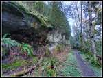 Sandstone Wall |
 Neat Lighting |
 Shade To Sunlight |
 Washed Out Spot |
Trips - 2022
Home