01-08-22
After
a Friday hike on New
Year's Eve and bad weather I did not hike the weekend of the first two
days of the year. I was ready to get out the second Saturday. The snow
was so heavy this week that all the mountain passes were closed. I-90
was closed from North Bend to Ellensburg. Everyone was looking for
hikes on the west side. I needed to get out but not get run over by the
crowds. The week long rain was supposed to be just a shower or two on
Saturday then clearing for Sunday. I chose to head to Cougar Mountain.
With an early start I hoped to avoid the later crowds It was cool at
the start but nothing like the sub 20 degrees we faced a week earlier.
I hoped all the rain washed out all the previous lowland snow. I also
figured the creeks would be running high. The snow weight and high
winds had also brought a lot of branches and trees down on other trails
this week. I hoped the lower elevation and heavy use would help to have
the trails passable. I was mostly right on my guesses.
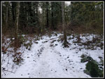
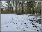
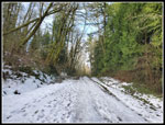
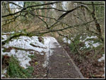
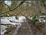
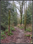
Procrastination kept me from getting out really early as I had a hard time finally deciding on Cougar Mountain. I arrived at Red Town about 8:30 am. The main lot as a bit more than half full. The lot at far left was empty. That is where I started. I was on the trail at 8:37 am. I figured on a big lollipop route with a clockwise loop. I seldom go to Coal Creek Falls as the water level is usually not that great and it is crowded. This time I figured I'd brave the crowds to see of all the snow and rain had it raging. I headed up the Military Road and then on to the Sky Country Trailhead. There, at about 1220' I found a bit of snow. Only a few short stretches of it covered the trail.
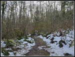
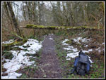
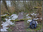
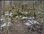
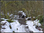
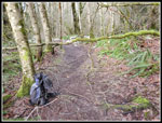
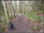
I went out to the Cave Hole Road and turned left. So far I had seen a few logs down on the trail that I could carry off the route. I moved a few more on the Cave Hole Road. At Fred's Railroad I turned left and started up the Klondike Swamp Trail. I went over a couple small logs and then someone called out asking if I was Jim. I did not think I was that easy to spot from the back. It was Leslie whom I know from NWHikers.net website. I have run into her on several occasions on Cougar Mountain. More than I would expect to run into anyone there. We talked while hiking for a few minutes then she continued on her run. I few minutes later I came to a 20'+ log across the trail. It was too high to go over and to low to easily go under. I brought a folding saw for just his type of occurrence. It was almost as wide as my saw. It was also a beginning to rot. That helped. I cut off the left side and then cut it again at the right edge of the trail. I was able to drag the middle piece of the trail. Mission accomplished.
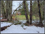
I took the Lost Beagle Trail up to the top of Anti-Aircraft Peak. I cut out two more hanging branches here. The top was covered with a couple inches of snow. It will soon be gone. I stopped at the covered picnic building for a food and water break. I arrived at 10:03 am. About 3.5 miles done in 1:26 including trail maintenance time. Heading out I went over to the Million Dollar View. Not great but I cold clearly see Lake Sammamish. A little blue but still almost entirely cloudy sky. I was very surprised to see zero cars in the lot at the trailhead here. The road was covered n a thin coating of packed snow/ice. I guess folks did not want to try the last bit of road to the lot. I can't recall ever seeing no cars at 10:15 am on a Saturday. So far I had seen a few runners but that was it. Mission Solitude was working well.
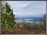
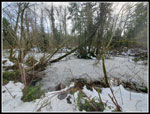
I headed over to the Clay Pit next. Most of the snow disappeared as I descended. It reappeared as I climbed to the Clay Pit. Just before the bridge over Tibbetts Creek a tree fell right on the trail. It had many small branches that made for a mess to push through to get by. I did get by and then I stopped, turned around, and went back. Out came the saw and I took off about 6 or 7 branches to create an open space to walk through. The tree is still there but it no longer blocks the way. Up at the Clay Pit I went over to the eastward view. The top of Tiger Mountain was in clouds. At least for the morning I made the right choice. Much bigger crowds over there and no views. Next I headed over to the East Fork Trail out of the Clay Pit. In places it was a creek. I bought high top waterproof boots so I kept dry feet. I don't think anyone in trail runners did so. There were a number of branches hanging over the trail. I cut them out in three places. One encompassed 4 or 5 branches. Major improvements to the trail.
I reached Fred's Railroad and turned left. In a short distance I reached the Quarry Trail. I started to run into people now. Not a lot but a person or two every 10-15 minutes. I turned off onto the trail down to Coal Creek Falls. I had two groups ahead of me. They were hiking slow and I went by them. I reached the falls during a lull. I had a chance to take photos and a few video clips before the next bunch of hikers arrived. Coal Creek Falls is not a huge drop but it had enough water this day to be pretty impressive. I have seen it with more flow but only a time or two. Well worth the crowds. It was 12:00 pm when I left the falls. The trail back to the Cave Hole Road had a steady stream of hikers coming up. No surprise there. I did see a pileated woodpecker not far from the trail. My phone camera only has a 2x optical zoom so the photos were not so great.
When I reached the Cave Hole Road I had two choices. Left downhill back to the trailhead or right uphill back to my route up. I chose right. It added a little elevation gain and would put me just over 8 miles hiked. I planned a much longer hike the next day so 8 miles would be plenty for this day. I turned left onto the trail back to the Sky Country Trailhead and encountered a little more snow. I saw some folks coming up the Military Road but it was much less crowded than the Cave Hole Road would have been. I arrived back at the trailhead at 12:49 pm. The lot was now jammed with cars. Exactly as I expected. My route avoided most of the crowd except at and below Coal Creek Falls. For the day I hiked just over 8 miles with 1200' of elevation gain. I carried and umbrella but never used it.
This trip was almost perfect. On a day when all the trails and skiing in the mountains were closed due to too much snow and avalanches, I missed the masses that were in close in trails. Cougar had crowds as the day went on but my early start and route avoided much of it. I cut out more than half a dozen logs and branches and moved several dozen logs off the trails. All that and I as on my way home before 1:00 pm. A very good warm up hike for the trip on Sunday.
Click on thumbnails to get
larger pictures.
Trips - 2022
Home
Procrastination kept me from getting out really early as I had a hard time finally deciding on Cougar Mountain. I arrived at Red Town about 8:30 am. The main lot as a bit more than half full. The lot at far left was empty. That is where I started. I was on the trail at 8:37 am. I figured on a big lollipop route with a clockwise loop. I seldom go to Coal Creek Falls as the water level is usually not that great and it is crowded. This time I figured I'd brave the crowds to see of all the snow and rain had it raging. I headed up the Military Road and then on to the Sky Country Trailhead. There, at about 1220' I found a bit of snow. Only a few short stretches of it covered the trail.
I went out to the Cave Hole Road and turned left. So far I had seen a few logs down on the trail that I could carry off the route. I moved a few more on the Cave Hole Road. At Fred's Railroad I turned left and started up the Klondike Swamp Trail. I went over a couple small logs and then someone called out asking if I was Jim. I did not think I was that easy to spot from the back. It was Leslie whom I know from NWHikers.net website. I have run into her on several occasions on Cougar Mountain. More than I would expect to run into anyone there. We talked while hiking for a few minutes then she continued on her run. I few minutes later I came to a 20'+ log across the trail. It was too high to go over and to low to easily go under. I brought a folding saw for just his type of occurrence. It was almost as wide as my saw. It was also a beginning to rot. That helped. I cut off the left side and then cut it again at the right edge of the trail. I was able to drag the middle piece of the trail. Mission accomplished.
I took the Lost Beagle Trail up to the top of Anti-Aircraft Peak. I cut out two more hanging branches here. The top was covered with a couple inches of snow. It will soon be gone. I stopped at the covered picnic building for a food and water break. I arrived at 10:03 am. About 3.5 miles done in 1:26 including trail maintenance time. Heading out I went over to the Million Dollar View. Not great but I cold clearly see Lake Sammamish. A little blue but still almost entirely cloudy sky. I was very surprised to see zero cars in the lot at the trailhead here. The road was covered n a thin coating of packed snow/ice. I guess folks did not want to try the last bit of road to the lot. I can't recall ever seeing no cars at 10:15 am on a Saturday. So far I had seen a few runners but that was it. Mission Solitude was working well.
I headed over to the Clay Pit next. Most of the snow disappeared as I descended. It reappeared as I climbed to the Clay Pit. Just before the bridge over Tibbetts Creek a tree fell right on the trail. It had many small branches that made for a mess to push through to get by. I did get by and then I stopped, turned around, and went back. Out came the saw and I took off about 6 or 7 branches to create an open space to walk through. The tree is still there but it no longer blocks the way. Up at the Clay Pit I went over to the eastward view. The top of Tiger Mountain was in clouds. At least for the morning I made the right choice. Much bigger crowds over there and no views. Next I headed over to the East Fork Trail out of the Clay Pit. In places it was a creek. I bought high top waterproof boots so I kept dry feet. I don't think anyone in trail runners did so. There were a number of branches hanging over the trail. I cut them out in three places. One encompassed 4 or 5 branches. Major improvements to the trail.
I reached Fred's Railroad and turned left. In a short distance I reached the Quarry Trail. I started to run into people now. Not a lot but a person or two every 10-15 minutes. I turned off onto the trail down to Coal Creek Falls. I had two groups ahead of me. They were hiking slow and I went by them. I reached the falls during a lull. I had a chance to take photos and a few video clips before the next bunch of hikers arrived. Coal Creek Falls is not a huge drop but it had enough water this day to be pretty impressive. I have seen it with more flow but only a time or two. Well worth the crowds. It was 12:00 pm when I left the falls. The trail back to the Cave Hole Road had a steady stream of hikers coming up. No surprise there. I did see a pileated woodpecker not far from the trail. My phone camera only has a 2x optical zoom so the photos were not so great.
When I reached the Cave Hole Road I had two choices. Left downhill back to the trailhead or right uphill back to my route up. I chose right. It added a little elevation gain and would put me just over 8 miles hiked. I planned a much longer hike the next day so 8 miles would be plenty for this day. I turned left onto the trail back to the Sky Country Trailhead and encountered a little more snow. I saw some folks coming up the Military Road but it was much less crowded than the Cave Hole Road would have been. I arrived back at the trailhead at 12:49 pm. The lot was now jammed with cars. Exactly as I expected. My route avoided most of the crowd except at and below Coal Creek Falls. For the day I hiked just over 8 miles with 1200' of elevation gain. I carried and umbrella but never used it.
This trip was almost perfect. On a day when all the trails and skiing in the mountains were closed due to too much snow and avalanches, I missed the masses that were in close in trails. Cougar had crowds as the day went on but my early start and route avoided much of it. I cut out more than half a dozen logs and branches and moved several dozen logs off the trails. All that and I as on my way home before 1:00 pm. A very good warm up hike for the trip on Sunday.
 First Snow |
 Klondike Swamp Trail |
 Log Across Trail |
 Log Cut Out |
 AA Peak Summit |
 Picnic Shelters |
 Million Dollar View |
 More Sawing |
 Tibbetts Creek Bridge |
 Clay Pit Viewpoint |
 Clay Pit Road |
 Mine Shaft Vent |
 Jerry's Duck Pond |
 Branches Down |
 Branches Cut |
 Lon In The Way |
 Log Is Gone |
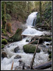 Coal Creek Falls |
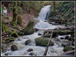 Falls Again |
 Woodpecker |
 Military Road |
Trips - 2022
Home