03-06-22
Gary
was free for a Sunday hike. We
did a headlamp hike on Thursday evening. Gary hiked on Friday. I hiked
on Saturday. We were looking for an easy trip for our third hike in
four days. With rain and no snow for a while in the mountains we
decided to do a snow free lower elevation trip. I did not have any good
ideas for a new trip. Gary suggested he show me some of his favorite
hikes on Fidalgo Island near Anacortes. I thought that sounded like a
good idea. It looked to be a clear day with a high near 50 degrees. The
morning would be cold. We chose not to get a really early start and let
it warm up a little. We met
at Ash Way Park and Ride at 7:45 am. We were both about 8 minutes
early. We headed north for Anacortes. Washington Park would be our
first destination. Gary has hiked there a number of times. I had not
done any of his suggested hikes.
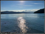
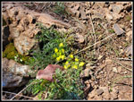
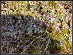
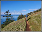
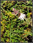
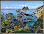
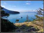
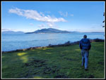
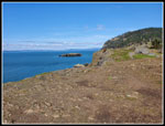
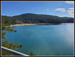
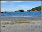
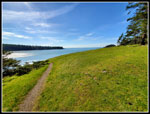
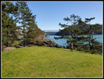
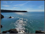
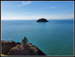
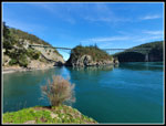
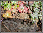
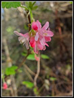
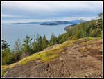
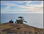
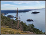
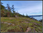
We arrived at Washington Park at 8:50 am. By 8:56 am we were on our way. There are a lot of trail junctions in the park. Gary led the way and I just tagged along. Our route was roughly a clockwise loop all the way around the periphery. Some of it on the main loop trail and some on side trails that often headed closer to the water. The loop provided a changing view as we worked our our way around. In one spot we were able to get down to the water. In another we had benches with views high above the water. There were a few small wildflowers in bloom. North Seattle was in pea soup fog. We had clouds most of the drive north. For the hikes we had blue sky. The low morning sunshine really it up the blue water. At times my photos looked to be over saturated with no processing. Madrona trees are something I don't see on mountain hikes. A bit more color to see.
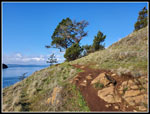
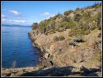
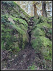
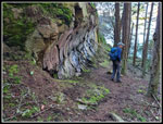
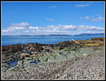
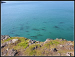
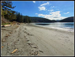
Our off the main trail routes had a few hands on scramble sections. None were hard. Gary showed my the "lave tube". It is a convex half tube cut into rock. Most unexpected. At times we saw boats plying the waters below us. We saw a few people but not many most of the way around. We intersected the road through the park. A trail off of it took us down to a gravelly beach. We could see Mt. Constitution on Orcas Island across the water. We reached Green Point which has a lot of green grass. A few folks here but not crowded. Our pace was not fast. Lots of stops to admire the views. Lots of photo stops too. It was 11:05 am when we reached the car. The first of three planned trails was a big success. I had a great time. For this section the gps showed we hiked 2,92 miles with 485' of gain.
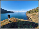
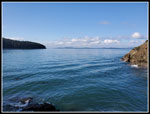
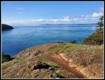
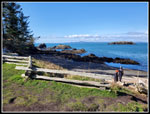
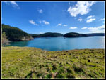
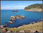
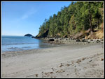
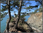
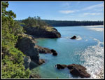
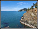
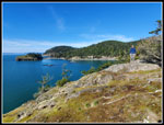
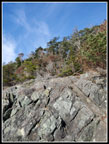
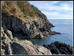
Next we headed south to Rosario Head. All of our trips were along the west coast of Fidalgo Island. It was 11:26 am when we started hiking. The lot was mostly full when we arrived. Now we started seeing more people. It was now in the mid 40s and still sunny. It was pleasant in the sunshine but still chilly in the shade. It is still winter. The trail brought us down to the narrow neck of land that connects to Rosario Head. As with all these points that jut out into the saltwater, you need to climb up to the top. They all have steep cliffs down to the water. Rosario Head is very grassy on top with some forest and provides great views all around. We had a bit of wind here and it was quite chilly. There are several small islands off the point. They have white and back rock that really contrasted with the bright blue water. I took way too may photos.
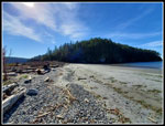
We could see Lighthouse Point to the south around Bowman Bay. Our plan was to hike the trail around there and then back. We left Rosario Head and started on the trail around the bay. We quickly saw a sign that said "No pets allowed", a temporary closure. We did not any pets and continued on. The trail climbs up and steeply drops to the beach on the bay. We walked the beach until we reached a sign and red plastic netting stating the beach was temporarily closed. It seems that seals or sea lions had calves on the beach. Well, that was not part of the plan. We headed inland to take the trail around the beach. Nope, not today. The trail was closed with the plastic net fence. We went out to the road and the spur road to the end of the beach was closed. There appeared to be no way around.
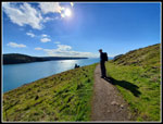
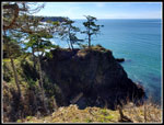
On the way in we overshot the entrance and Gary noticed the parking lot where one can park and access a trail along the main road to the Deception Pass Bridge was closed. We met a volunteer and he said the parking lot had a sink hole and so was closed. That left no way to get to the one trail that drops from the main road to Lighthouse Point. We had lunch on the beach then headed back to the car near Rosario Head. We hiked 2.01 miles with 308' of gain on this leg of the day. Rather than give up, Gary suggested we drive the road towards the Deception Pass Bridge and see if we could find a parking spot alongside the road. In fact we found a spot with one a spot open. It was now 12:45 pm. A short steep trail brought us down to a neck of land leading across to Lighthouse Point. On our right was Bowman Bay and to the left was Lottie Bay. Gary led the way across and then uphill onto the point.
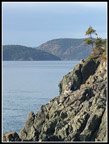
A short way up we stopped where another group had stopped. Below in Lottie Bay were about five sea lions. My 2x zoom phone camera did not get a close up shot but Gary brought a point and shoot camera with a much better zoom. He managed some shots. Once again we did a clockwise loop around the point. Once again we climbed up to some great viewpoints. We were now just north of Deception Pass. We could see more of the Deception Pass State Park on the sough side of the pass. As we worked our way around we saw some trails heading down. The were very steep and not something I would try. One was in shoulder high salal and we could not see where it was going. We gave it a try. It led to a narrow point jutting out into the water. Only about 6-9 feet wide with a big drop to the rocks and water below. A boot path dropped a little and climbed up to the top. There was one iffy very narrow step. Neither of us wanted to try it. I did manage to scramble straight up and then work my way out to the end. Not a place if you are afraid of heights. I took a few photos and scurried back. We climbed back up to the main trail.
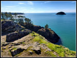
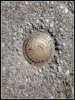
A trail cuts back to the start across the center of the point and another trail continues around the edge. Gary tried going all the way around once before and found it to be not entirely safe. We opted to go on good trail to a viewpoint and then turn around. At the viewpoint we took another break and soaked up the views. To the north is Rosario Had and Bowman Bay. Behind them is a big hill with tall cliffs. That is the location of Sharpe Park, our final destination of the day. I would have been happy sitting at our viewpoint for another hour but the day was sipping away and Sharpe Park awaited us. We reluctantly packed up and headed back. Back at the land bridge between the bays took a photo of a benchmark in the trail. The elevation is marked as 6.32'. The lowest benchmark I have seen. It is for triangulation. Where the trail starts climbing back up to the road we took a right turn. Our map showed a trail around to Lottie Point. That is the only place for the day that Gary had not hiked before;
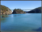
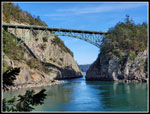
The route followed the water than climbed steeply to the top of a point. There is one scramble spot on the way. We dropped back down and made it to the viewpoint at Lottie Point. There were two other groups there already. The Deception Pass Bridge is not far away. We had a front row seat into Deception Pass. A really neat viewpoint. I would have spent more time but we had more to see this day. We took another trail around the point and avoided that nasty step. Back up the steep trail to the road and the car. Hike #3 was 2.45 miles with 545' of gain. The traffic coming across the bridge northbound had no gaps. There was no way to get a U-Turn. We had to go across the bridge and turnaround at the traffic light into the park. We came back and continued north to Sharpe Park. It was now 3:00 pm. Just over 6 hours since we started hiking.
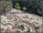
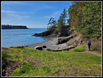
There are quite a few trails in the park. Gary just showed me a few of them. This time we did a counterclockwise loop. We passed a big cattail march with a couple of skunk cabbage getting started blooming. The route climbed up and then dropped down. From there much of the way was high above the water as the trail descended. Partly in forest we had some views out. At one point Gary left the trail and scramble down some open rock to a nice vantage point. More great views. We could not get down tot he water but had great views where we were. We too yet another long break. Across a gap to our left we saw a couple at another rocky perch. They did climb down to the water than back up again. This might have been the best spot of the day. That is a tough choice as there were a number of them.
Two more hikers followed our route and stopped above us. All too soon we had to go. Back up the trail and around to where we saw the first folks. The woman said she took a photo of us and did we want a copy. A minute later Gary had a text with the photo. Technology can be pretty useful. We worked our way up and to the south to Sares Head. There is a viewpoint there with a bench. Several more people were there. Some clouds were starting to build but we still had some sunshine. This stoop was pretty quick. It is a nice viewpoint. A few minutes away is Machin Viewpoint. It is as little higher and has a good view to the south. From here I could clearly see planes at Whidbey Island NAS. Now it was 4:42 pm. We had 1:02 until sunset. We hoofed it back to the car at a fast pace. By 5:02 we were back. Our fourth and last hike of the day covered 2.44 miles with 632' of gain.
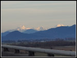
None of our hikes was long or had much elevation gain. Still, added together they totaled 9.8 miles with almost 2000' of gain. With all our stops and photos we manged to take over 8 hours to complete the trip. This was a very unusual trip and a great one. Lots to see and not oriented to a forest walk to a destination. Nearly the whole trip had views out in many directions. On the drive back we saw Whitehorse and Three Fingers Mountains lit up by the low evening sunshine. A very striking view. We made it back to Lynnwood right about at darkness. We took advantage or nearly the entire day for this trip. Short hikes near the cities is not my choice when the high mountain meadows are open. These ones will be on my return list for the winter season.
Click on thumbnails to get
larger pictures.
Trips - 2022
Home
We arrived at Washington Park at 8:50 am. By 8:56 am we were on our way. There are a lot of trail junctions in the park. Gary led the way and I just tagged along. Our route was roughly a clockwise loop all the way around the periphery. Some of it on the main loop trail and some on side trails that often headed closer to the water. The loop provided a changing view as we worked our our way around. In one spot we were able to get down to the water. In another we had benches with views high above the water. There were a few small wildflowers in bloom. North Seattle was in pea soup fog. We had clouds most of the drive north. For the hikes we had blue sky. The low morning sunshine really it up the blue water. At times my photos looked to be over saturated with no processing. Madrona trees are something I don't see on mountain hikes. A bit more color to see.
Our off the main trail routes had a few hands on scramble sections. None were hard. Gary showed my the "lave tube". It is a convex half tube cut into rock. Most unexpected. At times we saw boats plying the waters below us. We saw a few people but not many most of the way around. We intersected the road through the park. A trail off of it took us down to a gravelly beach. We could see Mt. Constitution on Orcas Island across the water. We reached Green Point which has a lot of green grass. A few folks here but not crowded. Our pace was not fast. Lots of stops to admire the views. Lots of photo stops too. It was 11:05 am when we reached the car. The first of three planned trails was a big success. I had a great time. For this section the gps showed we hiked 2,92 miles with 485' of gain.
Next we headed south to Rosario Head. All of our trips were along the west coast of Fidalgo Island. It was 11:26 am when we started hiking. The lot was mostly full when we arrived. Now we started seeing more people. It was now in the mid 40s and still sunny. It was pleasant in the sunshine but still chilly in the shade. It is still winter. The trail brought us down to the narrow neck of land that connects to Rosario Head. As with all these points that jut out into the saltwater, you need to climb up to the top. They all have steep cliffs down to the water. Rosario Head is very grassy on top with some forest and provides great views all around. We had a bit of wind here and it was quite chilly. There are several small islands off the point. They have white and back rock that really contrasted with the bright blue water. I took way too may photos.
We could see Lighthouse Point to the south around Bowman Bay. Our plan was to hike the trail around there and then back. We left Rosario Head and started on the trail around the bay. We quickly saw a sign that said "No pets allowed", a temporary closure. We did not any pets and continued on. The trail climbs up and steeply drops to the beach on the bay. We walked the beach until we reached a sign and red plastic netting stating the beach was temporarily closed. It seems that seals or sea lions had calves on the beach. Well, that was not part of the plan. We headed inland to take the trail around the beach. Nope, not today. The trail was closed with the plastic net fence. We went out to the road and the spur road to the end of the beach was closed. There appeared to be no way around.
On the way in we overshot the entrance and Gary noticed the parking lot where one can park and access a trail along the main road to the Deception Pass Bridge was closed. We met a volunteer and he said the parking lot had a sink hole and so was closed. That left no way to get to the one trail that drops from the main road to Lighthouse Point. We had lunch on the beach then headed back to the car near Rosario Head. We hiked 2.01 miles with 308' of gain on this leg of the day. Rather than give up, Gary suggested we drive the road towards the Deception Pass Bridge and see if we could find a parking spot alongside the road. In fact we found a spot with one a spot open. It was now 12:45 pm. A short steep trail brought us down to a neck of land leading across to Lighthouse Point. On our right was Bowman Bay and to the left was Lottie Bay. Gary led the way across and then uphill onto the point.
A short way up we stopped where another group had stopped. Below in Lottie Bay were about five sea lions. My 2x zoom phone camera did not get a close up shot but Gary brought a point and shoot camera with a much better zoom. He managed some shots. Once again we did a clockwise loop around the point. Once again we climbed up to some great viewpoints. We were now just north of Deception Pass. We could see more of the Deception Pass State Park on the sough side of the pass. As we worked our way around we saw some trails heading down. The were very steep and not something I would try. One was in shoulder high salal and we could not see where it was going. We gave it a try. It led to a narrow point jutting out into the water. Only about 6-9 feet wide with a big drop to the rocks and water below. A boot path dropped a little and climbed up to the top. There was one iffy very narrow step. Neither of us wanted to try it. I did manage to scramble straight up and then work my way out to the end. Not a place if you are afraid of heights. I took a few photos and scurried back. We climbed back up to the main trail.
A trail cuts back to the start across the center of the point and another trail continues around the edge. Gary tried going all the way around once before and found it to be not entirely safe. We opted to go on good trail to a viewpoint and then turn around. At the viewpoint we took another break and soaked up the views. To the north is Rosario Had and Bowman Bay. Behind them is a big hill with tall cliffs. That is the location of Sharpe Park, our final destination of the day. I would have been happy sitting at our viewpoint for another hour but the day was sipping away and Sharpe Park awaited us. We reluctantly packed up and headed back. Back at the land bridge between the bays took a photo of a benchmark in the trail. The elevation is marked as 6.32'. The lowest benchmark I have seen. It is for triangulation. Where the trail starts climbing back up to the road we took a right turn. Our map showed a trail around to Lottie Point. That is the only place for the day that Gary had not hiked before;
The route followed the water than climbed steeply to the top of a point. There is one scramble spot on the way. We dropped back down and made it to the viewpoint at Lottie Point. There were two other groups there already. The Deception Pass Bridge is not far away. We had a front row seat into Deception Pass. A really neat viewpoint. I would have spent more time but we had more to see this day. We took another trail around the point and avoided that nasty step. Back up the steep trail to the road and the car. Hike #3 was 2.45 miles with 545' of gain. The traffic coming across the bridge northbound had no gaps. There was no way to get a U-Turn. We had to go across the bridge and turnaround at the traffic light into the park. We came back and continued north to Sharpe Park. It was now 3:00 pm. Just over 6 hours since we started hiking.
There are quite a few trails in the park. Gary just showed me a few of them. This time we did a counterclockwise loop. We passed a big cattail march with a couple of skunk cabbage getting started blooming. The route climbed up and then dropped down. From there much of the way was high above the water as the trail descended. Partly in forest we had some views out. At one point Gary left the trail and scramble down some open rock to a nice vantage point. More great views. We could not get down tot he water but had great views where we were. We too yet another long break. Across a gap to our left we saw a couple at another rocky perch. They did climb down to the water than back up again. This might have been the best spot of the day. That is a tough choice as there were a number of them.
Two more hikers followed our route and stopped above us. All too soon we had to go. Back up the trail and around to where we saw the first folks. The woman said she took a photo of us and did we want a copy. A minute later Gary had a text with the photo. Technology can be pretty useful. We worked our way up and to the south to Sares Head. There is a viewpoint there with a bench. Several more people were there. Some clouds were starting to build but we still had some sunshine. This stoop was pretty quick. It is a nice viewpoint. A few minutes away is Machin Viewpoint. It is as little higher and has a good view to the south. From here I could clearly see planes at Whidbey Island NAS. Now it was 4:42 pm. We had 1:02 until sunset. We hoofed it back to the car at a fast pace. By 5:02 we were back. Our fourth and last hike of the day covered 2.44 miles with 632' of gain.
None of our hikes was long or had much elevation gain. Still, added together they totaled 9.8 miles with almost 2000' of gain. With all our stops and photos we manged to take over 8 hours to complete the trip. This was a very unusual trip and a great one. Lots to see and not oriented to a forest walk to a destination. Nearly the whole trip had views out in many directions. On the drive back we saw Whitehorse and Three Fingers Mountains lit up by the low evening sunshine. A very striking view. We made it back to Lynnwood right about at darkness. We took advantage or nearly the entire day for this trip. Short hikes near the cities is not my choice when the high mountain meadows are open. These ones will be on my return list for the winter season.
 Morning Sunlight |
 Yellow Wildflower |
 Tiny Flowers |
 Open Slopes |
 Vivid Colors |
 Trail Ahead |
 Gary Looking Out |
 Prairie Star? |
 Madrona Trees |
 Our Trail |
 Lava Tube? |
 At Sea Level |
 Boat Heading Out |
 Bright Ground Cover |
 Bench |
 On The Beach |
 Green Point |
 Trip 2, Rosario Head |
 Bowman Bay |
 Long Shadow |
 Looking North |
 Kelp |
 Great Colors |
 Rosario Head Park |
 Bowman Bay Again |
 On The Beach |
 Looking Back |
 Trail Back To Rosario |
 Beach To Lighthouse Pt |
 View To Rosario Head |
 Seal Or Sea Lion |
 Deception Pass |
 Down To Sea Level |
 Lighthouse Pt Meadow |
 Nice View |
 Me On Precarious Perch |
 Perch View |
 Light On Water |
 View North |
 My Perch Spot |
 Rocky Scenery |
 Folks Below |
 Gary At Break Spot |
 6.32' Elevation |
 Lottie Point View |
 Deception Pass Lottie |
 Sharp Park Rocks |
 Gary & Me |
 Folks On Rocks |
 Small Flowers |
 Colorful Flowers |
 Sares Head Viewpoint |
 Olympic Mountains |
 Machin Viewpoint |
 Machin Bench |
 Whitehorse & 3 Fingers |
Trips - 2022
Home