Fragrance
Lake-Rock Trail Loop
04-24-22Gary
was free for a Sunday hike.
With clouds moving in we decided to pass on a snowy climb to a summit.
We were also a bit tired of hikes in the Issaquah Alps. Time to get at
least a little way out of town. We settled on a trip near Bellingham on
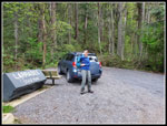
Chuckanut Mountain. We met in Lynnwood at 6:55 am and headed north. We
exited to
Chuckanut Drive and up to the HiLine Road and the trailhead for the Two
Dollar Trail. There was an accident on Chuckanut Drive that added about
12 minutes to our drive. We arrived at 8:18 am. By 8:25 am we were
packed
and ready to go. There was one guy parked at the trailhead. Diagonal
across blocking several other spots. When we pulled in he went nuts,
screaming in his car, then pulled out. Someone was not having a good
morning. Parking at a trailhead on a weekend is generally not a good
plan to get away from humanity.
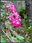
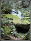
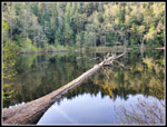
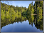
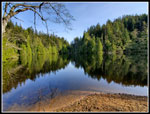
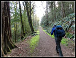
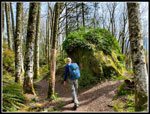
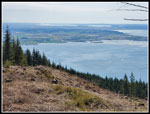
The Two Dollar Trail begins with a quick climb up to the ridge top. Some moderately long gentle switchbacks. The immediate uphill served to warm us up. We hoped to enjoy some sunshine and get back before late afternoon rain. The forecast turned out to be way off. Wildflowers are just getting going on the way to Fragrance Lake. We saw some red currants and little else. Things improved later on. The waterfall was running but without much water. We arrived at Fragrance Lake at 9:07 am. Our plan was to go clockwise around the late coming and going. We quickly reached a spot with a great view of the lake. The morning light was excellent. We went slow and took a number of photos going around the lake.
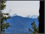
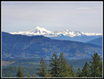
We had seen only a couple of runners coming out as we hiked in. At the lake we could hear other hikers. It is not empty, even early on a Sunday Morning. The other folks had come up from Chuckanut Drive. While hiking around the lake we saw some blooming skunk cabbage and salmonberry. Part way around we descended to the shore and again where we left the lake. The lighting was different in each place. The calm water provided some good reflection shots. At the far end we left the lake. The trail meets the trail up from Chuckanut and then reaches the old road. This is where we started and ended our loop. We went left and began the climb up to Cleator Road. The old road is now soft dirt with grass on the sides. It is looking like a trail now. There are some good sized trees along here. While uphill all the way, the grade is not steep. We arrived at Cleator Road at 9:43 am. The .90 miles only took 20 minutes. Part way up where the road touches the ridge top, we headed over for a shot of Mt. Baker. It is the only spot to see Baker, or so we thought.
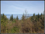
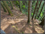
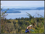
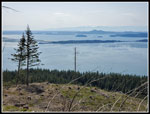
The Cyrus Gates Overlook is a popular pace for mountain bikers. I have often seen them drive up and then bike downhill. We saw one car pass us going down on our way up. There weer only two vehicles in the lot. It is often near full on a clear weekend day. We took a break and nobody arrived until just as we were leaving. The overlook provides a view to the west. The view is narrowing as trees keep growing. We stopped for food and water and some viewpoint photos. We may have stayed longer but the bugs were pretty bad. I did not expect a small black bug cloud following me around this early in the year. We arrived at 10:03 am and left at 10:13 am. Now came one of my favorite parts of the trip. Our descent down the Rock Trail. The trail uses steep stairways in places. They have no hand rails. Slipping is not an option.
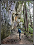
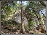
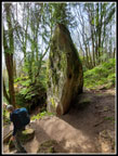
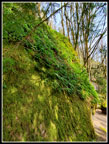
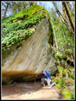
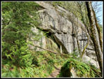
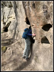
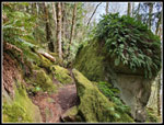
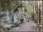
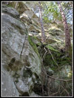
The stairs lose quite a bit of elevation very quickly. from there the route traverses a steep hillside with sandstone cliffs above. Sandstone is often seen on Utah but not in Washington State. I always hike this trail slowly and take lots of photos. Today was no different. Recent trips, including one in February, had quite a few people on the trail. This day we saw only a few groups. In places the rock overhangs the trail. In other places the trail descends by going around big boulders that have broken off and fallen. All the rocks off of the wall are covered in moss and licorice ferns. We still had some sunshine and the deciduous trees without leaves yet threw shadows on the rock walls. In pl;aces water runs down the rock. In places there is yellow and red coloring on the rock. Gary noticed a huge rock with a gap underneath one end. Someone had placed a skinny stick that appears to hold up the tons of rock. We stopped at the pockmarks. There are pockets or shelves cut in the rock. Perfect to still your head into. There are even three levels to choose from. We stopped for headless hiker photos. I have a gallery full of them now.
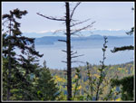
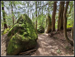
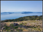
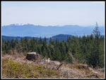
We dropped below the sandstone walls and entered an area with lots of boulders. Again, they all have moss and ferns covering them. Sward ferns cover much of the ground. We passed a muddy spot with skunk cabbage in bloom. The trail levels out near the bottom. Gary noticed a small rock "cave" just off the trail. It was bigger inside than it seemed. We met a lone hiker along here to. He mentioned a viewpoint of which I was not aware. We had a pretty good idea where it was from his description. We soon reached the South Lost Lake Trail. Gary had turned left towards Lost Lake. This time we turned right. The trail is an old road that has narrowed down to a nice trail. The route climbs slowly and steadily higher. The highpoint is at a junction. Our trail back to Fragrance Lake turns right. We went the other way. The route leaves the state park and continues as a logging road. We switched back a short way to a viewpoint. The bushes and trees are growing fast but we had views out to the water and Olympic Mountains. It was time for a lunch break.
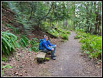
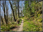
We arrived at this spot at 11:35 am. Once we stooped the bugs appeared one again. By 11:51 am we were back on our way. We poked around and found a couple other viewpoints. We returned to the junction and took the left turn heading towards Fragrance Lake. We were still on an old road narrowed to a nice trail. This was most all in forest. Salt water was not far away but we just had glimpses through the trees. We were too early for wildflowers along here. I had seen a decent display on other springs. Now we had more downhill than uphill. Easy hiking in a nice forest. We were passed by one group of younger and faster hikers. We set a good pace but were not in a big hurry to get back. The route crossed the steep Double Diamond Trail coming down from the top of the Rock Trail. A few minutes later we were back at the road. a right turn completed our loop. We headed left into the forest for the short hike back to Fragrance Lake. Just before the lake we turned left again and crossed a low bridge. This trail took us around the lake and back to where we first reached it.
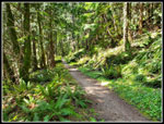
The trail is shorter on this side of the lake. It also has ups and downs as it goes below a huge sandstone rock wall. The sandstone alone is plenty scenic. There is one spot where you can drop to the lake level and get a view across it. Otherwise, we could see a bit of the lake through the trees but had no clear view of it. We reached the outlet at about 2:27 pm. We now just had 1.7 miles on the Two Dollar Trail to get back to the trailhead. The trail has a few good sized ups on the way down. They were not very noticeably steep on the way in. After a long day, they seemed a bit steeper. We made it back to the start at 3:13 pm. For the day we hiked just under 11 miles with about 2400' of elevation gain. Clouds did start to come in a little at the end. Mostly it was sunny all day long. So much for the forecast. It was much better than we expected.
This was Gary's first time on the second half of this trip. It's fun when one of us does a trail for the first time. The weather was outstanding all day. We saw folks coming and going at Fragrance Lake. We did not see as many folks as I expected on the rest of the hike. The Rock Trail was especially quiet for a sunny weekend day. I ended up with a lot of photos. We had an accident slow us down on the way out just like on the way in. Still, was not that bad. During the summer I will be up in the mountains. This hike is excellent when I want a snow free trip in the winter and spring. All in all, we had a great hike.
Click on thumbnails to get
larger pictures.
Trips - 2022
Home
The Two Dollar Trail begins with a quick climb up to the ridge top. Some moderately long gentle switchbacks. The immediate uphill served to warm us up. We hoped to enjoy some sunshine and get back before late afternoon rain. The forecast turned out to be way off. Wildflowers are just getting going on the way to Fragrance Lake. We saw some red currants and little else. Things improved later on. The waterfall was running but without much water. We arrived at Fragrance Lake at 9:07 am. Our plan was to go clockwise around the late coming and going. We quickly reached a spot with a great view of the lake. The morning light was excellent. We went slow and took a number of photos going around the lake.
We had seen only a couple of runners coming out as we hiked in. At the lake we could hear other hikers. It is not empty, even early on a Sunday Morning. The other folks had come up from Chuckanut Drive. While hiking around the lake we saw some blooming skunk cabbage and salmonberry. Part way around we descended to the shore and again where we left the lake. The lighting was different in each place. The calm water provided some good reflection shots. At the far end we left the lake. The trail meets the trail up from Chuckanut and then reaches the old road. This is where we started and ended our loop. We went left and began the climb up to Cleator Road. The old road is now soft dirt with grass on the sides. It is looking like a trail now. There are some good sized trees along here. While uphill all the way, the grade is not steep. We arrived at Cleator Road at 9:43 am. The .90 miles only took 20 minutes. Part way up where the road touches the ridge top, we headed over for a shot of Mt. Baker. It is the only spot to see Baker, or so we thought.
The Cyrus Gates Overlook is a popular pace for mountain bikers. I have often seen them drive up and then bike downhill. We saw one car pass us going down on our way up. There weer only two vehicles in the lot. It is often near full on a clear weekend day. We took a break and nobody arrived until just as we were leaving. The overlook provides a view to the west. The view is narrowing as trees keep growing. We stopped for food and water and some viewpoint photos. We may have stayed longer but the bugs were pretty bad. I did not expect a small black bug cloud following me around this early in the year. We arrived at 10:03 am and left at 10:13 am. Now came one of my favorite parts of the trip. Our descent down the Rock Trail. The trail uses steep stairways in places. They have no hand rails. Slipping is not an option.
The stairs lose quite a bit of elevation very quickly. from there the route traverses a steep hillside with sandstone cliffs above. Sandstone is often seen on Utah but not in Washington State. I always hike this trail slowly and take lots of photos. Today was no different. Recent trips, including one in February, had quite a few people on the trail. This day we saw only a few groups. In places the rock overhangs the trail. In other places the trail descends by going around big boulders that have broken off and fallen. All the rocks off of the wall are covered in moss and licorice ferns. We still had some sunshine and the deciduous trees without leaves yet threw shadows on the rock walls. In pl;aces water runs down the rock. In places there is yellow and red coloring on the rock. Gary noticed a huge rock with a gap underneath one end. Someone had placed a skinny stick that appears to hold up the tons of rock. We stopped at the pockmarks. There are pockets or shelves cut in the rock. Perfect to still your head into. There are even three levels to choose from. We stopped for headless hiker photos. I have a gallery full of them now.
We dropped below the sandstone walls and entered an area with lots of boulders. Again, they all have moss and ferns covering them. Sward ferns cover much of the ground. We passed a muddy spot with skunk cabbage in bloom. The trail levels out near the bottom. Gary noticed a small rock "cave" just off the trail. It was bigger inside than it seemed. We met a lone hiker along here to. He mentioned a viewpoint of which I was not aware. We had a pretty good idea where it was from his description. We soon reached the South Lost Lake Trail. Gary had turned left towards Lost Lake. This time we turned right. The trail is an old road that has narrowed down to a nice trail. The route climbs slowly and steadily higher. The highpoint is at a junction. Our trail back to Fragrance Lake turns right. We went the other way. The route leaves the state park and continues as a logging road. We switched back a short way to a viewpoint. The bushes and trees are growing fast but we had views out to the water and Olympic Mountains. It was time for a lunch break.
We arrived at this spot at 11:35 am. Once we stooped the bugs appeared one again. By 11:51 am we were back on our way. We poked around and found a couple other viewpoints. We returned to the junction and took the left turn heading towards Fragrance Lake. We were still on an old road narrowed to a nice trail. This was most all in forest. Salt water was not far away but we just had glimpses through the trees. We were too early for wildflowers along here. I had seen a decent display on other springs. Now we had more downhill than uphill. Easy hiking in a nice forest. We were passed by one group of younger and faster hikers. We set a good pace but were not in a big hurry to get back. The route crossed the steep Double Diamond Trail coming down from the top of the Rock Trail. A few minutes later we were back at the road. a right turn completed our loop. We headed left into the forest for the short hike back to Fragrance Lake. Just before the lake we turned left again and crossed a low bridge. This trail took us around the lake and back to where we first reached it.
The trail is shorter on this side of the lake. It also has ups and downs as it goes below a huge sandstone rock wall. The sandstone alone is plenty scenic. There is one spot where you can drop to the lake level and get a view across it. Otherwise, we could see a bit of the lake through the trees but had no clear view of it. We reached the outlet at about 2:27 pm. We now just had 1.7 miles on the Two Dollar Trail to get back to the trailhead. The trail has a few good sized ups on the way down. They were not very noticeably steep on the way in. After a long day, they seemed a bit steeper. We made it back to the start at 3:13 pm. For the day we hiked just under 11 miles with about 2400' of elevation gain. Clouds did start to come in a little at the end. Mostly it was sunny all day long. So much for the forecast. It was much better than we expected.
This was Gary's first time on the second half of this trip. It's fun when one of us does a trail for the first time. The weather was outstanding all day. We saw folks coming and going at Fragrance Lake. We did not see as many folks as I expected on the rest of the hike. The Rock Trail was especially quiet for a sunny weekend day. I ended up with a lot of photos. We had an accident slow us down on the way out just like on the way in. Still, was not that bad. During the summer I will be up in the mountains. This hike is excellent when I want a snow free trip in the winter and spring. All in all, we had a great hike.
 Ready To Go |
 First View |
 Red Currants |
 Happy Gary |
 Waterfall |
 Log On Lake |
 Skunk Cabbage |
 Nice Reflection |
 Fragrance Lake |
 Heading For Cleator Rd |
 Mt. Baker View |
 Cyrus Gates Overlook |
 Rock Trail Steps |
 Along Rock Wall |
 Looking Up |
 Mossy Rocks |
 Skinny Rock |
 Moss & Fern Rock |
 Don't Do It! |
 Shadows |
 Headless Hiker |
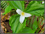 Trillium |
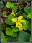 Yellow Violets |
 Fern Rock |
 Lot Of Green |
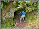 Caver Gary |
 Gary On The Trail |
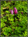 Bleeding Hearts |
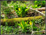 More Skunk Cabbages |
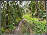 Road Turned Trail |
 First Viewpoint |
 Mt. Baker Viewpoint |
 View South |
 San Juan Islands |
 Clouds Haven't Arrived |
 Snowy Ridge |
 On The Trail Back |
 Nice Forest |
 Rock Wall |
 Wall Along Lake |
Trips - 2022
Home