07-31-22
I
had a meeting with a client in
Buckley on Sunday morning. I just needed a signature. She grew up in
that area and suggested I hike up Mt. Peak. I thought that was a great
idea. I have been aware of the hike for at least 25 years. I just could
not take a day for driving just over 100 miles round trip for a 2 or 3
mile hike with 1000' of elevation gain. On the other hand, after doing
a hike farther up Highway 410 that takes all day, I did not want to
gain another 1000' on the way home. Recently, I had seen that a new
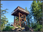
fire lookout tower was built on the summit. The previous lookout was
taken down in 1966. One more reason to go take a look. My appointment
was at 10:00 am so I headed out at 6:00 am. Three lanes of I-5 were
closed down for major repairs on weekends this summer. I was early
enough to sail right through.
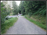
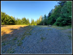
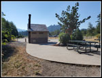
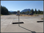
I headed south on 167 then through Auburn and on towards Enumclaw. I cut over to Highway 410 and a few blocks later I turned onto Mud Mountain Road. 52 miles later I reached the Pinnacle Peak parking lot. The lot was plenty large enough for the cars parked there. Unfortunately, the gate was locked at 7:00 am. There were a couple spots still available on the side of the road. Looking at the map, I saw that the short way up is on the north side. It is either 1 mile or less than that on the steeper route. 1000' of gain in one mile is the less steep trail. On the south side the routes are longer. There is a road that goes part way up and there are a number of trails that parallel the road or gut up through switchbacks to shorten the way. There are a number of trails on the map beyond the road..
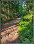
I started out at 7:04 am. The trail heads over to the start of the road route. The night before I turned off my phones Internet connection and made sure I had the area mapped. Yes, I did. I started the GPS app to track my way and show all the trails. I had just a grid with no map. Crap? There are a number of trails and a map is very helpful if you have not hiked here before. I managed to download a small map that did have all the trails. I took the first trail I saw after getting the map downloaded. It was still pretty cool though we were on our way to a record sixth consecutive day over 90 degrees. I soon saw the first party coming down. More than a few people had very early starts.
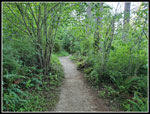
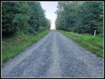
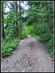
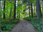
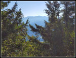
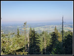
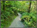
The trail reached the road once again. I chose to take the road. I wanted to see if there were any views out and the road was a bit longer. I was trying to get close to 4 miles total hiking. The road was pretty steep. It was more gentle lower down but I did need to gain at least 1000'. I could have crossed the road and taken a dirt trail that was shorter. The trails are mostly in very good shape. At the end of the road is a grass spot. Just before is a minimal view out. From there it is back into forest on trail to the summit. I chose the longer trails to maximize mileage. Higher up I had small window views out to farms and houses below. Near where the north and my south side trail meet I turned off on a longer route. It traversed over to a shorter trail from the road end. Along the way it drops about 40'. Along here I passed half a dozen patches of Indian pipe that has recently popped out of the ground. The day before on Tiger Mountain I found some big patches of fresh Indian pipe. I don't see it often but this weekend it was on both hikes
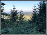
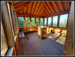
The trail meets the shorter trail and then heads steeply for the summit. There is some basalt rock that the trail climbs up. Dirt trail with basalt rocks to use like steps. Easily the steepest part of the day. Before long I saw the lookout tower right above me. I headed up the steps. The tower raises you up but not enough to get above the trees. The forest has grown a lot since 1966. In 56 years small evergreen trees become big trees. Again, there were a few narrow views out but not much. Mt. Rainier was close by but I could not see it at all. I asked two groups if they knew of a viewpoint and one said yes and gave me an idea of where to look on my way down. I was on top at 7:57 am. I hiked up 1.96 miles in 53 minutes. With photo stops included that was not too bad. Google said my appointment was only 8 minutes away from the parking lot. I needed to spend some time on top to get down at 9:45 am. I spent 48 minutes on top. Half a dozen groups came and mostly went. At 8:45 am I headed down.
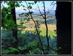
I checked out a short trail just below the tower. It had a viewpoint but no Mt. Rainier. I then headed down the trail. Not far down I saw a boot path heading left. In 75' I came to a very good view of Mt. Rainier. I was a little surprised I found it. It was a bit hazy but still a good look at the mountain. I retraced my stops back to the road and then stayed on road for one switchback and left the road farther down for a trail that runs right alongside the road. That added just a little extra distance. I reached the parking lot at 9:39. I made it to my appointment a few minutes early.
It was just too hot for me to hike in the afternoon. This day I took care of business after getting in an early morning hike. I liked the trails and the new lookout building. Mt. Peak is still a long drive for me to get in a very short hike. By taking the longer routes I managed to get my hike up to exactly 4 miles with just under 1200' of elevation gain. Not bad for an early morning hike. I probably will not hike this peak often but I am glad to finally make it to the top.
Click on thumbnails to get
larger pictures.
Trips - 2022
Home
I headed south on 167 then through Auburn and on towards Enumclaw. I cut over to Highway 410 and a few blocks later I turned onto Mud Mountain Road. 52 miles later I reached the Pinnacle Peak parking lot. The lot was plenty large enough for the cars parked there. Unfortunately, the gate was locked at 7:00 am. There were a couple spots still available on the side of the road. Looking at the map, I saw that the short way up is on the north side. It is either 1 mile or less than that on the steeper route. 1000' of gain in one mile is the less steep trail. On the south side the routes are longer. There is a road that goes part way up and there are a number of trails that parallel the road or gut up through switchbacks to shorten the way. There are a number of trails on the map beyond the road..
I started out at 7:04 am. The trail heads over to the start of the road route. The night before I turned off my phones Internet connection and made sure I had the area mapped. Yes, I did. I started the GPS app to track my way and show all the trails. I had just a grid with no map. Crap? There are a number of trails and a map is very helpful if you have not hiked here before. I managed to download a small map that did have all the trails. I took the first trail I saw after getting the map downloaded. It was still pretty cool though we were on our way to a record sixth consecutive day over 90 degrees. I soon saw the first party coming down. More than a few people had very early starts.
The trail reached the road once again. I chose to take the road. I wanted to see if there were any views out and the road was a bit longer. I was trying to get close to 4 miles total hiking. The road was pretty steep. It was more gentle lower down but I did need to gain at least 1000'. I could have crossed the road and taken a dirt trail that was shorter. The trails are mostly in very good shape. At the end of the road is a grass spot. Just before is a minimal view out. From there it is back into forest on trail to the summit. I chose the longer trails to maximize mileage. Higher up I had small window views out to farms and houses below. Near where the north and my south side trail meet I turned off on a longer route. It traversed over to a shorter trail from the road end. Along the way it drops about 40'. Along here I passed half a dozen patches of Indian pipe that has recently popped out of the ground. The day before on Tiger Mountain I found some big patches of fresh Indian pipe. I don't see it often but this weekend it was on both hikes
The trail meets the shorter trail and then heads steeply for the summit. There is some basalt rock that the trail climbs up. Dirt trail with basalt rocks to use like steps. Easily the steepest part of the day. Before long I saw the lookout tower right above me. I headed up the steps. The tower raises you up but not enough to get above the trees. The forest has grown a lot since 1966. In 56 years small evergreen trees become big trees. Again, there were a few narrow views out but not much. Mt. Rainier was close by but I could not see it at all. I asked two groups if they knew of a viewpoint and one said yes and gave me an idea of where to look on my way down. I was on top at 7:57 am. I hiked up 1.96 miles in 53 minutes. With photo stops included that was not too bad. Google said my appointment was only 8 minutes away from the parking lot. I needed to spend some time on top to get down at 9:45 am. I spent 48 minutes on top. Half a dozen groups came and mostly went. At 8:45 am I headed down.
I checked out a short trail just below the tower. It had a viewpoint but no Mt. Rainier. I then headed down the trail. Not far down I saw a boot path heading left. In 75' I came to a very good view of Mt. Rainier. I was a little surprised I found it. It was a bit hazy but still a good look at the mountain. I retraced my stops back to the road and then stayed on road for one switchback and left the road farther down for a trail that runs right alongside the road. That added just a little extra distance. I reached the parking lot at 9:39. I made it to my appointment a few minutes early.
It was just too hot for me to hike in the afternoon. This day I took care of business after getting in an early morning hike. I liked the trails and the new lookout building. Mt. Peak is still a long drive for me to get in a very short hike. By taking the longer routes I managed to get my hike up to exactly 4 miles with just under 1200' of elevation gain. Not bad for an early morning hike. I probably will not hike this peak often but I am glad to finally make it to the top.
 Starting Up The Road |
 Onto Trail |
 Back On Steep Road |
 First Small View Out |
 End Of The Road |
 Wider Rocky Trail |
 Better View Out |
 Nice Colors |
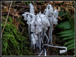 Indian Pipe |
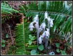 More Indian Pipe |
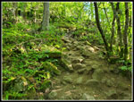 Rocky Near Top |
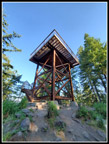 Lookout Tower |
 Lookout View |
 Lookout Interior |
 Better Lookout View |
 Down The Stairs |
 Yellow Flower |
 Leaving Lookout |
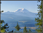 Mt. Rainier |
 Descending Wider Trail |
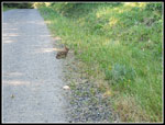 Rabbit On The Road |
 Lower Trail |
 Trailhead Amenities |
 Parking Lot |
Trips - 2022
Home