09-18-22
John
was free for a Sunday hike.
Highway 2 was closed down for a fire. I-90 would be a mess. We chose to
head north. I had only done Cascade Pass-Sahale Arm three times in 40
years. It is such a great hike. It was time to hike it again. Daylight
is getting shorter. This is a very popular hike. The parking lot fills
up fast. For those reasons we met in Lynnwood at 6:00 am. Traffic was
light and we made good time. The dirt portion of the Cascade River Road
has been recently graded. We saw almost no pot holes. I had the same
conditions on my last
visit on the same weekend in
2014. There is a little washboard but it is not bad. We made very good
time on that section and arrived at the trailhead at 8:06 am. The last
two miles we were stuck behind cars going very slow and not willing to
let us pass. We took one of the last few spots available. The views
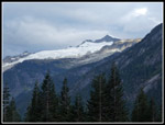
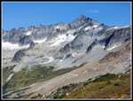
from the parking lot are really good. The steep wall of Johannesburg
Mountain and Eldorado Peak are in view. We were packed and on our way
at 8:19 am.
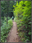
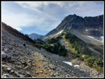
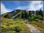
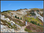
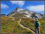
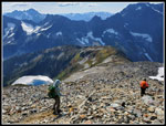
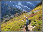
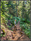
We hiked up Tiger 1 and 2 two days earlier. That was a humid hike with 2800' of gain. I was a little slow getting going and John hiked fast to warm up. I was glad when we settled down to a slightly slower pace. The 3.7 mile to Cascade Pass is pretty smooth and easy. The grade is steady but not steep, I read that there are 37 switchbacks. I believe it. We passed several groups on the way up. Much of the way is in nice forest but there are only a few views. There is a lot of pearly everlasting in bloom. There is not much else. We did see some asters in bloom. There are some gentians but they have not fully opened yet.
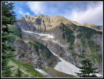
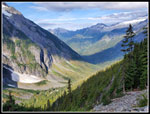
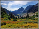
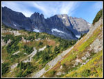
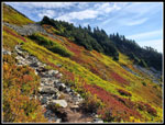
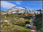
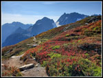
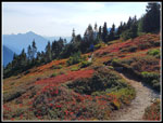
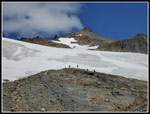
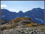
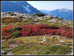
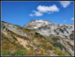
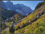
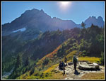
A mile of so from the pas the trail breaks out of the forest. Now there are good views to Johannesburg and peaks down the valley. We started taking more photos from here on. Just before the pass, we could see the old trail. That predates my hikes here. My first hike was on 8-27-88, my second was on 9-09-95, and my last one was on 9-20-14. All of them have been in late August or September. We reached Cascade Pass at 9:47 am. It was windy enough that I put on my windshirt. The easy part was done. Now came the steep climb to Sahale Glacier Camp. Photos from the most recent trip report a week earlier showed the berry bushes to be still green. They are quickly turning color. They are not yet at peak but we had some good fall color higher up. We had lots of company for the climb up to Sahale Arm. Lots of hikers stopping for lots of photos. The views just keep getting better as you ascend.
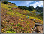
There were some ripe berries but they were very small. The sun was still pretty low in the sky and provided some good backlighting. The lit up leaves were quite colorful. We left the pass at 9:54 am and reached the Arm at 10:25 am. It took 31 minutes to hike just .60 miles.gaining 660'. Once on the Arm the already fantastic views were even better. Sahale Peak was now in sight with Doubtful Lake far below. Views to the west, north and close in south were great. To the east it was smoky haze. Later on we would be able to see farther south and that too was hazy. The sun was behind us as we hiked up Sahale Arm. That meant that leaves ahead were drab. Behind us the leaves were backlit and much more colorful. We had to keep stopping to look back and enjoy and photograph the good leaf colors. Just below Sahale Peak we could see the glacier. That was our destination. It looked to be along way away.
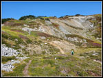
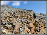
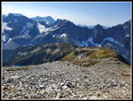
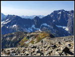
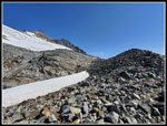
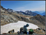
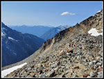
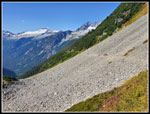
Ascending to the Arm we left the high winds. I took my windshirt off part way up. I did not need it on the hike up the Arm though it was windy in places. The sky was half white when we started but clouds gave way to blue sky as the day went on. It was probably in the low 50s but with the sunshine it felt warmer. I had only done one trip to as much as 6700' this year and John was similar. The altitude actually slowed us down high up. Our destination was at 7600'. There are a lot of rocky steps above Cascade Pass. It was a chore climbing up and knee pounding coming down. That slowed us down too. High on the Arm the well defined trail gives way to a boot path and then a rock field. We lost the trail in talus and found it again. There are cairns to help get back on track. By that point you can also just go straight uphill. Along the way we kept getting new views to see. The Hidden Peak Lookout is tiny but visible from Sahale Arm. Late, John noticed that we could see Hidden Lake too. A low spot between peaks is filled with a view of Mt. Baker from one spot.
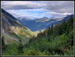
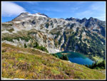
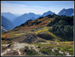
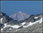
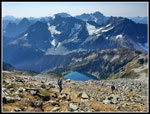
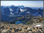
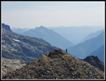
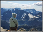
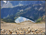
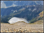
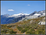
We finally crested the rocky hillside to reach Sahale Glacier Camp at 11:54 am. With lots of photo stops we took 3:35 coming up. John had relatives in town and did a Monday hike, our Thursday Tiger hike, and this trip on Sunday. He had 8,000' of elevation gain for the week. I just had 6800'. A reason to be a bit tired after the 4000' ascent. There were lots of other people up there. A couple folks were ascending the glacier towards the summit of Sahale Peak. Others were all around on rocky high points. We went up a little higher to an empty campsite with great views. Doubtful Lake was 2200' right below us. The entire curved Arm was laid out below. We could now see over the ridge to the south. Sloan Peak was hazy but easily spotted. Bonanza and Spider Mountain stood out. To the east were 9114' Mt. Buckner, 9200' Mt. Goode, and 8284' Mt. Booker. To the south the top of Glacier Peak was visible but was soon in clouds. I also found White Chuck Mountain and Mt. Pugh. Many other peaks I did not recognize. Looking south, we saw the larger glaciers on the north side of the peaks.
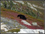
We were not in a hurry to head down. Even with some haze, the views are really outstanding. I suggested heading down at 1:00 pm but that came and went. We finally packed up and started down at 1:29 pm. We had 1:35 on top. The steep boot path on loose dirt with loose rocks is a touch way to get started. It gets better as you descend. We have more experience than many others heading down and passed three or four other groups. As we neared the bottom of the rocks we met a couple heading up. They mentioned seeing a bear not far below and another one on the lower part of the Arm. We saw a large group of hikers ahead and soon saw a bear. It was busy eating while the hikers above were busy watching it. Just as we arrived the bear moved out of sight and crossed over the ridge top. We were just too late to get any photos. Well we did see the bear even if it was at a distance. The first one I have seen in 6 or 7 years.
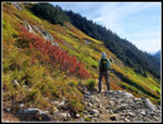
The views are laid out in front of you on the descent. The view east down the valley was getting a little clearer. The peaks to the south went out of sight as we descended. A little later we stopped to let hikers pass and they pointed out another bear below the ridge top. This time we were able to pull out our high zoom cameras and get some good shots of the bear. This one was average sized. The first one we saw was huge. We continued down many hard rock steps as we made our way down. We took a food and water break where the trail leaves Sahale Arm. The trail is narrow and there were quite a few groups below us. The descent would not be fast. We had some more bright backlit leaves on this section of the hike. We had seen many groups still coming up on our way down. As we neared Cascade Pass we saw several more large groups coming up. It seemed that the campers at the glacier were all coming up late in the day.
We did not stop at the pass. Now with just 3.7 miles to go we sped up. We left the pass at 3:02 pm. At first, there were more good photo opportunities. When we entered the forest the cameras were mostly put away. We made good time the rest of the way down. The trailhead was reached at 4:15 pm. We took 1:13 to come down the last 3.7 miles. The drive home went better than expected. We had a slowdown north of Everett but no worse than most Sunday's. Having Highway 2 closed did not mess up I-5 though a check showed a big backup on I-90 at 6:45 pm. We made a good choice.
It amazes me that this was only my fourth time on this route. This is one incredibly beautiful hike. I have not seen it in mid summer but I do love it in the fall. The last par ti steep and rocky but there is no exposure. It is just a hike. It was warming up below the pass and we found it in the mid 60s at the trailhead. It reached the low 70s on our drive home. We had clouds for much of the ascent then mostly clear sky and warm for the descent. A nice pattern after the humid hike on Thursday. I ended up with a whole lot of photos and a lot of memories. A near perfect fall hike.
Click on thumbnails to get
larger pictures.
Trips - 2022
Home
We hiked up Tiger 1 and 2 two days earlier. That was a humid hike with 2800' of gain. I was a little slow getting going and John hiked fast to warm up. I was glad when we settled down to a slightly slower pace. The 3.7 mile to Cascade Pass is pretty smooth and easy. The grade is steady but not steep, I read that there are 37 switchbacks. I believe it. We passed several groups on the way up. Much of the way is in nice forest but there are only a few views. There is a lot of pearly everlasting in bloom. There is not much else. We did see some asters in bloom. There are some gentians but they have not fully opened yet.
A mile of so from the pas the trail breaks out of the forest. Now there are good views to Johannesburg and peaks down the valley. We started taking more photos from here on. Just before the pass, we could see the old trail. That predates my hikes here. My first hike was on 8-27-88, my second was on 9-09-95, and my last one was on 9-20-14. All of them have been in late August or September. We reached Cascade Pass at 9:47 am. It was windy enough that I put on my windshirt. The easy part was done. Now came the steep climb to Sahale Glacier Camp. Photos from the most recent trip report a week earlier showed the berry bushes to be still green. They are quickly turning color. They are not yet at peak but we had some good fall color higher up. We had lots of company for the climb up to Sahale Arm. Lots of hikers stopping for lots of photos. The views just keep getting better as you ascend.
There were some ripe berries but they were very small. The sun was still pretty low in the sky and provided some good backlighting. The lit up leaves were quite colorful. We left the pass at 9:54 am and reached the Arm at 10:25 am. It took 31 minutes to hike just .60 miles.gaining 660'. Once on the Arm the already fantastic views were even better. Sahale Peak was now in sight with Doubtful Lake far below. Views to the west, north and close in south were great. To the east it was smoky haze. Later on we would be able to see farther south and that too was hazy. The sun was behind us as we hiked up Sahale Arm. That meant that leaves ahead were drab. Behind us the leaves were backlit and much more colorful. We had to keep stopping to look back and enjoy and photograph the good leaf colors. Just below Sahale Peak we could see the glacier. That was our destination. It looked to be along way away.
Ascending to the Arm we left the high winds. I took my windshirt off part way up. I did not need it on the hike up the Arm though it was windy in places. The sky was half white when we started but clouds gave way to blue sky as the day went on. It was probably in the low 50s but with the sunshine it felt warmer. I had only done one trip to as much as 6700' this year and John was similar. The altitude actually slowed us down high up. Our destination was at 7600'. There are a lot of rocky steps above Cascade Pass. It was a chore climbing up and knee pounding coming down. That slowed us down too. High on the Arm the well defined trail gives way to a boot path and then a rock field. We lost the trail in talus and found it again. There are cairns to help get back on track. By that point you can also just go straight uphill. Along the way we kept getting new views to see. The Hidden Peak Lookout is tiny but visible from Sahale Arm. Late, John noticed that we could see Hidden Lake too. A low spot between peaks is filled with a view of Mt. Baker from one spot.
We finally crested the rocky hillside to reach Sahale Glacier Camp at 11:54 am. With lots of photo stops we took 3:35 coming up. John had relatives in town and did a Monday hike, our Thursday Tiger hike, and this trip on Sunday. He had 8,000' of elevation gain for the week. I just had 6800'. A reason to be a bit tired after the 4000' ascent. There were lots of other people up there. A couple folks were ascending the glacier towards the summit of Sahale Peak. Others were all around on rocky high points. We went up a little higher to an empty campsite with great views. Doubtful Lake was 2200' right below us. The entire curved Arm was laid out below. We could now see over the ridge to the south. Sloan Peak was hazy but easily spotted. Bonanza and Spider Mountain stood out. To the east were 9114' Mt. Buckner, 9200' Mt. Goode, and 8284' Mt. Booker. To the south the top of Glacier Peak was visible but was soon in clouds. I also found White Chuck Mountain and Mt. Pugh. Many other peaks I did not recognize. Looking south, we saw the larger glaciers on the north side of the peaks.
We were not in a hurry to head down. Even with some haze, the views are really outstanding. I suggested heading down at 1:00 pm but that came and went. We finally packed up and started down at 1:29 pm. We had 1:35 on top. The steep boot path on loose dirt with loose rocks is a touch way to get started. It gets better as you descend. We have more experience than many others heading down and passed three or four other groups. As we neared the bottom of the rocks we met a couple heading up. They mentioned seeing a bear not far below and another one on the lower part of the Arm. We saw a large group of hikers ahead and soon saw a bear. It was busy eating while the hikers above were busy watching it. Just as we arrived the bear moved out of sight and crossed over the ridge top. We were just too late to get any photos. Well we did see the bear even if it was at a distance. The first one I have seen in 6 or 7 years.
The views are laid out in front of you on the descent. The view east down the valley was getting a little clearer. The peaks to the south went out of sight as we descended. A little later we stopped to let hikers pass and they pointed out another bear below the ridge top. This time we were able to pull out our high zoom cameras and get some good shots of the bear. This one was average sized. The first one we saw was huge. We continued down many hard rock steps as we made our way down. We took a food and water break where the trail leaves Sahale Arm. The trail is narrow and there were quite a few groups below us. The descent would not be fast. We had some more bright backlit leaves on this section of the hike. We had seen many groups still coming up on our way down. As we neared Cascade Pass we saw several more large groups coming up. It seemed that the campers at the glacier were all coming up late in the day.
We did not stop at the pass. Now with just 3.7 miles to go we sped up. We left the pass at 3:02 pm. At first, there were more good photo opportunities. When we entered the forest the cameras were mostly put away. We made good time the rest of the way down. The trailhead was reached at 4:15 pm. We took 1:13 to come down the last 3.7 miles. The drive home went better than expected. We had a slowdown north of Everett but no worse than most Sunday's. Having Highway 2 closed did not mess up I-5 though a check showed a big backup on I-90 at 6:45 pm. We made a good choice.
It amazes me that this was only my fourth time on this route. This is one incredibly beautiful hike. I have not seen it in mid summer but I do love it in the fall. The last par ti steep and rocky but there is no exposure. It is just a hike. It was warming up below the pass and we found it in the mid 60s at the trailhead. It reached the low 70s on our drive home. We had clouds for much of the ascent then mostly clear sky and warm for the descent. A nice pattern after the humid hike on Thursday. I ended up with a whole lot of photos and a lot of memories. A near perfect fall hike.
 Eldorado From Trailhead |
 Johannesburg Mountain |
 Nice Smooth Trail |
 Above Forest |
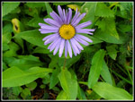 Aster |
 Sun On Valley |
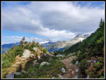 Sub Alpine |
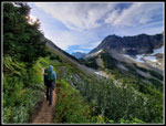 Heading For Pass |
 Crossing Talus Field |
 Looking East |
 Heading For Arm |
 Starting Up |
 Looking To Pass |
 Good Fall Colors |
 A Little Rocky |
 Pika |
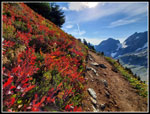 Great Fall Color! |
 Nearing Top Of Arm |
 Summit & Lake |
 Backlit Leaves |
 Sahale Arm |
 Hiker Heading Down |
 Climbing Up Arm |
 Trail Down Arm |
 Forbidden Peak |
 Our Route Up |
 Mt. Baker |
 Into The Rocks |
 Looking Down To Arm |
 John On The Rocks |
 Lake Is Below |
 Summit & Glacier |
 View South |
 Lunch Time |
 Great Campsite |
 Sahale Glacier |
 John & North Cascades |
 Reflection |
 Sparkling Water |
 Heading Down |
 John Leads Down |
 Off The Rocks |
 Eldorado Again |
 More Fall Color |
 Bear! |
 Lupine |
 Looking To Summit |
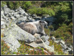 Marmot |
 John Descending |
 Nearing Pass |
 At Cascade Pass |
 Hikers On Talus Field |
 On Smooth Trail |
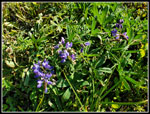
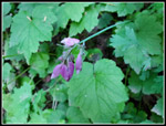 Blooming Bleeding Hearts |
Trips - 2022
Home