04-17-22
On
Easter Sunday I was free until early afternoon. I decided to get in a
morning hike. It was in the mid 30s when I left home. I considered
several choices. Most close in hikes either had too little elevation
gain or were ones I had been doing all winter. I decided to head to
Squak Mountain State Park's trailhead on the south side of the
mountain. I planned to hike up to Debbie's View then figure out where
else to go. At the start of the year I went up to DV then went over
West Peak and up to the Bullitt Fireplace. I headed down the Bullitt
Gorge Trail to close the loop and retraced my steps back to the
trailhead. That route is good for 7 mile with 1900' of gain. I arrived
at the trailhead right at about 8:00 am. It was 37 degrees. So much for
warm spring mornings. I was packed and on my way at 8:06 am.
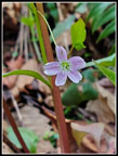
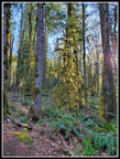
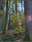
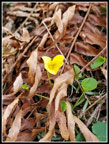
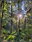
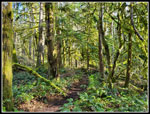
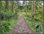
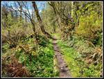
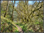
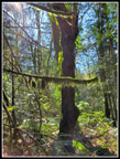
I have been seeing a pretty good early display of wildflowers the past couple weeks. I expected at least half a dozen wildflowers in bloom including yellow violets and trillium. Early on I found almost nothing. The trail is gently graded and is fast to hike. Photos were a bit difficult as I needed gloves at first. I soon did see some small spring beauty. They were just starting to open up. That was it for most of the way up to Debbie's View. I did see a single yellow violet. I checked the trail signs and immediately recalled that my gps has never agreed with the mileage listed. Two signs had the mileage about 20% higher. Where a sign said I had come 1.4 miles the gps said 1.15 miles. The marker at .50 does agree with the gps. The forest has a lot of trees with moss hanging all over them. With the low morning sun beginning to shine through I saw some neat effects. The moss seemed to have a bright halo around it. Many photos were taken.
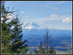
When I reached the Perimeter Trail I turned left. This trail took me up to the short spur to Debbie's View. One hiker passed by me on this section. He was about 35 years younger than me. I reached the spur trail at 9:06 am. I covered 2.6 mile in exactly one hour. On the spur to the viewpoint I caught up with two groups. That put 6 people right ahead. At Debbie's View there were about a dozen people. I managed to get in a few shots of Mt. Rainier. It was completely in the clear. I spent less than 5 minutes and I was back on my way. Up to the Perimeter Trail again and now I turned left. I followed it over to the top of the Margaret's Way Trail. A new trail is opposite Margaret's Way. I checked out the start of it back in January. I went up a short way and pulled out my phone map of Squak. I decided not to go over West Peak. Instead I would follow this new trail down the north side of Squak Mountain.
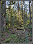
This new trail is very gently graded, smooth, and wide. It loses elevation slowly but is very easy on the knees. I descended 1.3 miles losing about 550'. I passed a couple groups heading up. When I reached the West Access Trail I turned right. I quickly reached a junction with the Bullitt Fireplace Trail. Now I turned right again and started regaining elevation. This was an old road and wide but rocky. It went right up the fall line at a relatively steep grade for a road. I might have hiked this trail 35 years ago but definitely not since then. Part way up I reached another junction. Straight ahead would continue up to the Bullitt Fireplace going by the Bullitt Gorge Trail I planned to use on my descent. Or I could go left. That would take me up to the other side of the fireplace or up to Central Peak. I decided to go left and decide later how to get back to the trailhead.
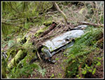
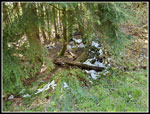
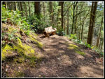
On the way up I noticed a whole car mostly buried just below the trail. In olden days on East Tiger or other routes on old logging roads it was not all that unusual to find a car or a washing machine in the forest. This car had been there quite a while. I next reached a junction I often hike by. It is on the lower route between Central Peak and the Bullitt Fireplace. I decided to continue hiking some new to me trails and go left up to Central Peak. I arrived there at 10:16 am. The climb up covered 760' of gain. I had now hiked 5.5 miles in 2:10. I had plenty of time for a longer descent route on more new to me trails. My 5 minute food and water break tied my stop at Debbie's View for the longest of the day. I then dropped down the road a short way and then down the quite steep Summit Trail to the Phil's Creek Trail. Just off the road there was some snow left. Not on the trail but there it was just below 2000'.
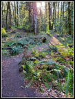
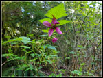
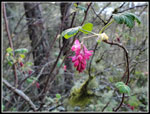
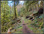
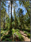
A short way along Phil's Creek is the turnoff for the East Ridge Trail. That is my usual route up Central Peak. The lower Phil's Creek Trail I had not been on. The sun was now up high enough to really shine down on me. Much of the trail along here is out in the open. No more wearing gloves. It was getting a bit warm. I had seen some trillium, a few yellow violets, and a few salmonberry flowers along my route. I kept an eye out for some flowers in this sunnier part of the trip. There was not much to see with one exception. About 3 or 4 years ago I considered hiking this trail. Trip reports mentioned that it was closed due to damage. A year or two back I saw a few trip reports mentioning that it was open again. I thought about checking out the trail but did not get around to it until this day. I found the trail to be a lot of fun to hike. It is open to horses and once across the creek it becomes wider with a very gentle grade.
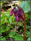
I passed one junction that goes out to the main summit road. At the next junction I turned left. Right goes to the road. Left continues down after crossing Phil's Creek. This junction was unsigned. One of the few without a sign. The creek is crossed immediately and I was now on the shady and forested side of the creek. All day I had been seeing hundreds of bleeding heart plants along the trail. None had even a single flower so far. On my last 3 non snow hikes I had seen exactly one plant in bloom each time. I quickly came upon exactly one bleeding heart plant in bloom. Like the others I have seen this year the blooms were a darker red than I am used to seeing. Perhaps the first ones in spring ore redder? I don't know. I took and erased half a dozen photos before I had one in focus. The trail then began a series of long gentle switchbacks. A 10% grade hikers trail would have descended in half the distance. It was a pretty forest and easy trail so I was fine with it.
The next junction is for the May Valley Loop Trail. Going left looked to be longer on the map and I was likely to be a little short of 9 miles on the day so I went left. The trail wound around and around as it continued to descend. I finally met the other part of the loop and the trail then dropped to cross the creek again. This bridge is pretty long. A short steep climb in forest turned to a flat traverse over to the main road. Descending the road is the shortest way back to the trailhead. I crossed the road and hiked trail to the next junction. This was a junction I hiked by in the morning. It was signed .50 miles to the trailhead. In short order I was back at the parking lot.
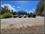
I arrived back at the trailhead at 11:41 am. It was now jam packed full. For the day I hiked 8.90 miles with about 2400' of elevation gain. More than half of the trip was on trails I had never hiked or might have hiked one time 35 years ago. After almost 40 years it is hard to find trails I have not hiked. That is especially true of trails within 30 minutes of my home. I was home more than early enough. Other than at Debbie's View, I saw only occasional hikers. I had long gaps of solitude in between. I maintained a good though not exceptionally fast pace. 8.9 miles in 3:35 total time works out to almost exactly 2.5 mph or 24 minutes per mile. Take out the 18 minutes not moving and it bumps up to 22 minutes per mile. I enjoyed the new trails and the old. I will design some new loops incorporating these trails. I had a fun day out from 37 degrees at the start to 52 degrees at the end.
Click on thumbnails to get
larger pictures.
Trips - 2022
Home
I have been seeing a pretty good early display of wildflowers the past couple weeks. I expected at least half a dozen wildflowers in bloom including yellow violets and trillium. Early on I found almost nothing. The trail is gently graded and is fast to hike. Photos were a bit difficult as I needed gloves at first. I soon did see some small spring beauty. They were just starting to open up. That was it for most of the way up to Debbie's View. I did see a single yellow violet. I checked the trail signs and immediately recalled that my gps has never agreed with the mileage listed. Two signs had the mileage about 20% higher. Where a sign said I had come 1.4 miles the gps said 1.15 miles. The marker at .50 does agree with the gps. The forest has a lot of trees with moss hanging all over them. With the low morning sun beginning to shine through I saw some neat effects. The moss seemed to have a bright halo around it. Many photos were taken.
When I reached the Perimeter Trail I turned left. This trail took me up to the short spur to Debbie's View. One hiker passed by me on this section. He was about 35 years younger than me. I reached the spur trail at 9:06 am. I covered 2.6 mile in exactly one hour. On the spur to the viewpoint I caught up with two groups. That put 6 people right ahead. At Debbie's View there were about a dozen people. I managed to get in a few shots of Mt. Rainier. It was completely in the clear. I spent less than 5 minutes and I was back on my way. Up to the Perimeter Trail again and now I turned left. I followed it over to the top of the Margaret's Way Trail. A new trail is opposite Margaret's Way. I checked out the start of it back in January. I went up a short way and pulled out my phone map of Squak. I decided not to go over West Peak. Instead I would follow this new trail down the north side of Squak Mountain.
This new trail is very gently graded, smooth, and wide. It loses elevation slowly but is very easy on the knees. I descended 1.3 miles losing about 550'. I passed a couple groups heading up. When I reached the West Access Trail I turned right. I quickly reached a junction with the Bullitt Fireplace Trail. Now I turned right again and started regaining elevation. This was an old road and wide but rocky. It went right up the fall line at a relatively steep grade for a road. I might have hiked this trail 35 years ago but definitely not since then. Part way up I reached another junction. Straight ahead would continue up to the Bullitt Fireplace going by the Bullitt Gorge Trail I planned to use on my descent. Or I could go left. That would take me up to the other side of the fireplace or up to Central Peak. I decided to go left and decide later how to get back to the trailhead.
On the way up I noticed a whole car mostly buried just below the trail. In olden days on East Tiger or other routes on old logging roads it was not all that unusual to find a car or a washing machine in the forest. This car had been there quite a while. I next reached a junction I often hike by. It is on the lower route between Central Peak and the Bullitt Fireplace. I decided to continue hiking some new to me trails and go left up to Central Peak. I arrived there at 10:16 am. The climb up covered 760' of gain. I had now hiked 5.5 miles in 2:10. I had plenty of time for a longer descent route on more new to me trails. My 5 minute food and water break tied my stop at Debbie's View for the longest of the day. I then dropped down the road a short way and then down the quite steep Summit Trail to the Phil's Creek Trail. Just off the road there was some snow left. Not on the trail but there it was just below 2000'.
A short way along Phil's Creek is the turnoff for the East Ridge Trail. That is my usual route up Central Peak. The lower Phil's Creek Trail I had not been on. The sun was now up high enough to really shine down on me. Much of the trail along here is out in the open. No more wearing gloves. It was getting a bit warm. I had seen some trillium, a few yellow violets, and a few salmonberry flowers along my route. I kept an eye out for some flowers in this sunnier part of the trip. There was not much to see with one exception. About 3 or 4 years ago I considered hiking this trail. Trip reports mentioned that it was closed due to damage. A year or two back I saw a few trip reports mentioning that it was open again. I thought about checking out the trail but did not get around to it until this day. I found the trail to be a lot of fun to hike. It is open to horses and once across the creek it becomes wider with a very gentle grade.
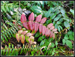
I passed one junction that goes out to the main summit road. At the next junction I turned left. Right goes to the road. Left continues down after crossing Phil's Creek. This junction was unsigned. One of the few without a sign. The creek is crossed immediately and I was now on the shady and forested side of the creek. All day I had been seeing hundreds of bleeding heart plants along the trail. None had even a single flower so far. On my last 3 non snow hikes I had seen exactly one plant in bloom each time. I quickly came upon exactly one bleeding heart plant in bloom. Like the others I have seen this year the blooms were a darker red than I am used to seeing. Perhaps the first ones in spring ore redder? I don't know. I took and erased half a dozen photos before I had one in focus. The trail then began a series of long gentle switchbacks. A 10% grade hikers trail would have descended in half the distance. It was a pretty forest and easy trail so I was fine with it.
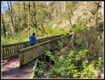
The next junction is for the May Valley Loop Trail. Going left looked to be longer on the map and I was likely to be a little short of 9 miles on the day so I went left. The trail wound around and around as it continued to descend. I finally met the other part of the loop and the trail then dropped to cross the creek again. This bridge is pretty long. A short steep climb in forest turned to a flat traverse over to the main road. Descending the road is the shortest way back to the trailhead. I crossed the road and hiked trail to the next junction. This was a junction I hiked by in the morning. It was signed .50 miles to the trailhead. In short order I was back at the parking lot.
I arrived back at the trailhead at 11:41 am. It was now jam packed full. For the day I hiked 8.90 miles with about 2400' of elevation gain. More than half of the trip was on trails I had never hiked or might have hiked one time 35 years ago. After almost 40 years it is hard to find trails I have not hiked. That is especially true of trails within 30 minutes of my home. I was home more than early enough. Other than at Debbie's View, I saw only occasional hikers. I had long gaps of solitude in between. I maintained a good though not exceptionally fast pace. 8.9 miles in 3:35 total time works out to almost exactly 2.5 mph or 24 minutes per mile. Take out the 18 minutes not moving and it bumps up to 22 minutes per mile. I enjoyed the new trails and the old. I will design some new loops incorporating these trails. I had a fun day out from 37 degrees at the start to 52 degrees at the end.
 Spring Beauty |
 Early Morning Light |
 Lit Up Tree |
 Cedar & Sun |
 Low Angle Sunshine |
 Yellow Violet |
 Bright Sun |
 Salmonberry Flower |
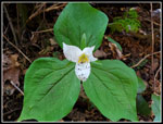 Trillium |
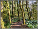 Mossy Trees |
 Sunny Spring Day |
 Colorful Leaves |
 Mt. Rainier From DV |
 Red Currants? |
 Mushroom |
 Smaller Trees |
 Old Road |
 Old Car |
 Recent Cutting |
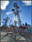 Central Peak Towers |
 Snow! |
 Big Fungus |
 Phil's Creek Trail |
 Getting Warmer |
 Grassy Trail |
 Nice Contrast |
 Bleeding Hearts |
 Bench |
 Glowing Moss |
 Big Bridge |
 Wide Angle |
 The Lot Is Full |
Trips - 2022
Home