02-17-24
The
forecast was for 30-40 mph wind gusts on Saturday south of Highway 2.
Up by Bellingham, the wind was supposed to be light. I chose to drive
up north. Of course, at 6:15 am, the winds near Seattle were light. I
have been doing a lot of hikes on the north side of Chuckanut Mountain
and it was time to get back on the Blanchard Hill side. I decided to go
north anyway. I was on the road at 6:53 am. The sunrise colors over the
Cascades from atop Phinney Ridge were spectacular. Driving north I had
more great views of Three Fingers and Mt. Baker. I thought with mostly
cloudy skies, the peaks would not be seen. I was very wrong. I exited
I-90 at Alger and headed to the upper trailhead on Blanchard Hill.
There was only one car in the lot and I passed a couple hikers heading
the short way down the road to the Lily Lake Trail. That clinched it. I
planned to redo a hike I did on 1-01-19. I managed to get the mileage
up to 11 on that trip. With the other group going up the Lily Lake
Trail I decided to start up the road and finish on the Lily Lake Trail.
I did not expect to see anyone on the trail for quite some time. I was
right. Also, going this way would give me views of Mt. Baker earlier
while the sky was still clear. That too proved to be a good choice.
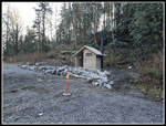
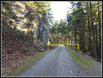
I arrived at the trailhead at 8:07 am. The sun was shining and it was 34 degrees. The first thing I noticed was a new outhouse. It looks to be very new. I last was here in 2022 and it was not in my trailhead photos. I packed up quickly and was on my was at 8:13 am. It is almost exactly 1 miles on the road to the Alternate Incline Trail. At the old quarry I saw mounds of gravel. They are using it again for road work. Across from the quarry is a narrow window with a view of Mt. Baker. The view was very good with some white sky but no clouds over the peak. I arrived at the Alternate Incline Trail at 8:34 am. A 21 minute mile with photo stops is a good pace for me. When I first hiked here 19 years ago, the Incline Trail was still open. I did not hike it that day. I returned 3 years later, in 2008, and it was closed. The Alternate Incline is shorter than the old trail as it has switchbacks. It is still a good workout. About a mile later I was at the junction with the PNT. Right quickly reaches Lizard Lake. Left heads on to Lily Lake and Oyster Dome. I would hike both routes this day. First I planned a short detour.
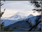
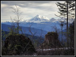
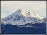
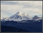
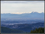
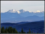
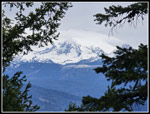
At the same junction, there is an unsigned bike path heading off. I have hiked this several times. It leads to a logging road. Gary, John, and I took it once on a long route to the far side of Lizard Lake. That trip included a lot of elevation loss and gain and a steep cross-country section to reach the lake. I had much easier plans this day. On another occasion, I hiked part way down the logging road to a view of Mt. Baker. That was my objective. The minimal bike path of a few years ago is now a very easy to follow bike trail. It climbs up and before reaching the logging road it enters a new clearcut. This just happens to provide a terrific view of Mt. Baker and the Twin Sisters peaks. My new phone camera has a 5x optical zoom and it proved much better than my old 2x zoom phone camera. At 10x it was partly optical and partly digital cropping but did provide pretty good photos. Baker now had sun shining on one side and looked much better than the photos from the quarry. I went a little farther then up a short spur to more views. Views north to Canadian peaks were now open. Lake Samish could be seen down below. The total detour added 1.06 miles to my trip.
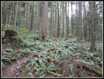
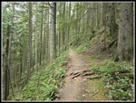
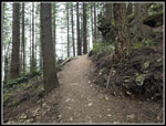
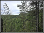
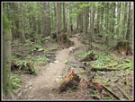
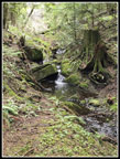
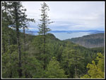
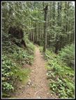
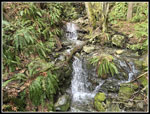
I hiked back to the junction and took the left trail towards Oyster Dome. This old logging railroad grade is mostly flat with a few short uphills. I next reached a trail heading left. This is the Lily Lake Trail that I would later take down to the parking lot. This time of year it is too early for wildflowers. I also did not see any mushrooms or saprophytes. Without those sights, it was mostly just a beauty of the forest. The next junction is left on the PNT towards the Samish Overlook. I continued straight and quickly reached the trail on the right to Lily Lake and North Butte. I would take that one later. The trail continues straight towards Oyster Dome. To the left is a marsh that will soon be loaded with bright yellow skunk cabbage. I looked carefully for a first bright green leaf coming up. None were seen. The marsh turns to a small creek and a new bridge crosses it. Previously, it was a rock hop across. The route descends and turns left. So far I had seen two bikers at a distance on the detour logging road. That was it. As I reached the junction with the Oyster Dome Trail I knew that would change. Just beyond the junction I passed a hiker. I saw many more going up and down the trail. My route had solitude. The Oyster Dome Trail from Chuckanut Drive or Samish Overlook has little solitude. The upper trail has been rebuilt in the past half dozen years and is much smother and gentler with more switchbacks now.
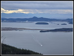
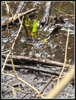
I reached Oyster Dome at 10:20 am. I had hiked exactly 5 miles in 2:07. I was almost half way through my trip. I had also gained most of the elevation. There were several groups at the viewpoint. More arrived and left continuously. It was now overcast and still cool though no longer near freezing. My brunch break lasted 18 minutes. I packed up and headed on at 10:38. I was at the lower viewpoint and headed back to the upper one for a few more photos. I then hiked the short distance to the actual high point of Oyster Dome. One guy was just leaving as I arrived. I climbed up on the rock and had views east to North Butte and north to peaks in Canada. After a few photos, I headed down. It was easy walking, though crowded, back to the Oyster Dome Trail junction. I did see several groups on the hike back to the Lily Lake/North Butte Trail though far less than on the Oyster Dome Trail. near the junction I looked carefully for skunk cabbage leaves and was rewarded with one set of bright green leaves above the marshy mud. A first sign of spring.
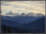
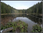
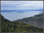
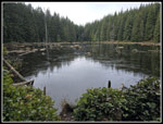
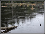
At the junction I turned left for the short hike to Lily Lake. I crossed the boardwalk to the point at the outlet. The lake had a little ice on it. The water level was much higher than in summer or fall. My stay was brief and I was back on the trail. The route follows the shore than climb up to North Butte. I passed the junction with the trail to Lizard Lake and continued up. I saw two hikers above me taking the new trail that winds up to the top of North Butte. I took the old straight up route and beat them to the top. It was still cloudy but some sun was seeping through. Again, I was in the open with zero wind. It was cold but the total lack of wind really helped make it comfortable. I was into my lunch when the other two hikers arrived on top. We had discussions on hiking and non-hiking topics. I reached the top at 11:21 am. I did not leave until 11:42 am. I went over to the Mt. Baker viewpoint. As the trees keep growing the great view is now a sort of view between tree branches. I could see that the summit was now under a cloud cap. I was glad to have had such good views of it on the way up.
I dropped down to the junction and headed left towards Lizard Lake. This trail was built well after my early visits. It makes it fast and east to go between Lily to Lizard Lakes. I arrived at Lizard Lake at 12.02 pm. One hiker was there but left as I arrived. Lizard Lake had more ice than Lily Lake. The patters in the ice made for some interesting photos. There were no skunk cabbage leaves up in the usual spot here so I headed on. In less than a quarter mile I was back at the big junction of the Alternative Incline, railroad grade to Oyster Dome, and bike trail to Mt. Baker Views. I could hike back the way I came to the parking lot in 2 miles. I chose the long way back.
For the second time this day I hiked the railroad grade. At the Lily Lake Trail, I turned left towards the trailhead. It is about 2.5 miles to the trailhead. I did not have quite enough miles done to reach 11 do I went a little farther on the PNT and then came back to the Lily Lake Trail. Mission accomplished. The 2.5 miles down has a few uphills but is mostly a moderately graded route that is easy on the knees. I passed one big group of mom's and daughters backpacking up to the lakes. The girls looked to be about 12 years old. I also saw a few groups of hikers coming up and about seven or eight groups of bikers coming up. The trail is narrow and places making it challenging to get off far enough for all those bikers to get by. While this was crowded compared to most of my trip, it was a fraction of the number on the Oyster Dome Trail. That 2.5 miles always seems like about 4 miles and this time was no exception. I was glad to reach the road. A few minutes later I was back in the parking lot. It was now full with cars parked along the road but there was still more room available.
If not for the very high wind warning I probably would not have driven 150 miles round trip for this hike. It was not all that expensive as I bought gas near Arlington for $3.19/gallon while the cheapest in NW Seattle is $4.39. I did avoid all the wind. It was cold in the morning but rose to 50F when I finished at 1:29 pm. For the day, I hiked 11 miles with about 2200' of gain. I visited two lakes and three viewpoints. I saw my first skunk cabbage leaves of the year but still have not seen a single wildflower in bloom. The Mt. Baker viewpoint is really good for less often seen view of the west side of the mountain. With an early finish I had almost no traffic slow downs all the way home. This turned out to be a very enjoyable day in some mountains right above an inlet of the Pacific Ocean.
Click on thumbnails to get
larger pictures.
Trips - 2024
Home
I arrived at the trailhead at 8:07 am. The sun was shining and it was 34 degrees. The first thing I noticed was a new outhouse. It looks to be very new. I last was here in 2022 and it was not in my trailhead photos. I packed up quickly and was on my was at 8:13 am. It is almost exactly 1 miles on the road to the Alternate Incline Trail. At the old quarry I saw mounds of gravel. They are using it again for road work. Across from the quarry is a narrow window with a view of Mt. Baker. The view was very good with some white sky but no clouds over the peak. I arrived at the Alternate Incline Trail at 8:34 am. A 21 minute mile with photo stops is a good pace for me. When I first hiked here 19 years ago, the Incline Trail was still open. I did not hike it that day. I returned 3 years later, in 2008, and it was closed. The Alternate Incline is shorter than the old trail as it has switchbacks. It is still a good workout. About a mile later I was at the junction with the PNT. Right quickly reaches Lizard Lake. Left heads on to Lily Lake and Oyster Dome. I would hike both routes this day. First I planned a short detour.
At the same junction, there is an unsigned bike path heading off. I have hiked this several times. It leads to a logging road. Gary, John, and I took it once on a long route to the far side of Lizard Lake. That trip included a lot of elevation loss and gain and a steep cross-country section to reach the lake. I had much easier plans this day. On another occasion, I hiked part way down the logging road to a view of Mt. Baker. That was my objective. The minimal bike path of a few years ago is now a very easy to follow bike trail. It climbs up and before reaching the logging road it enters a new clearcut. This just happens to provide a terrific view of Mt. Baker and the Twin Sisters peaks. My new phone camera has a 5x optical zoom and it proved much better than my old 2x zoom phone camera. At 10x it was partly optical and partly digital cropping but did provide pretty good photos. Baker now had sun shining on one side and looked much better than the photos from the quarry. I went a little farther then up a short spur to more views. Views north to Canadian peaks were now open. Lake Samish could be seen down below. The total detour added 1.06 miles to my trip.
I hiked back to the junction and took the left trail towards Oyster Dome. This old logging railroad grade is mostly flat with a few short uphills. I next reached a trail heading left. This is the Lily Lake Trail that I would later take down to the parking lot. This time of year it is too early for wildflowers. I also did not see any mushrooms or saprophytes. Without those sights, it was mostly just a beauty of the forest. The next junction is left on the PNT towards the Samish Overlook. I continued straight and quickly reached the trail on the right to Lily Lake and North Butte. I would take that one later. The trail continues straight towards Oyster Dome. To the left is a marsh that will soon be loaded with bright yellow skunk cabbage. I looked carefully for a first bright green leaf coming up. None were seen. The marsh turns to a small creek and a new bridge crosses it. Previously, it was a rock hop across. The route descends and turns left. So far I had seen two bikers at a distance on the detour logging road. That was it. As I reached the junction with the Oyster Dome Trail I knew that would change. Just beyond the junction I passed a hiker. I saw many more going up and down the trail. My route had solitude. The Oyster Dome Trail from Chuckanut Drive or Samish Overlook has little solitude. The upper trail has been rebuilt in the past half dozen years and is much smother and gentler with more switchbacks now.
I reached Oyster Dome at 10:20 am. I had hiked exactly 5 miles in 2:07. I was almost half way through my trip. I had also gained most of the elevation. There were several groups at the viewpoint. More arrived and left continuously. It was now overcast and still cool though no longer near freezing. My brunch break lasted 18 minutes. I packed up and headed on at 10:38. I was at the lower viewpoint and headed back to the upper one for a few more photos. I then hiked the short distance to the actual high point of Oyster Dome. One guy was just leaving as I arrived. I climbed up on the rock and had views east to North Butte and north to peaks in Canada. After a few photos, I headed down. It was easy walking, though crowded, back to the Oyster Dome Trail junction. I did see several groups on the hike back to the Lily Lake/North Butte Trail though far less than on the Oyster Dome Trail. near the junction I looked carefully for skunk cabbage leaves and was rewarded with one set of bright green leaves above the marshy mud. A first sign of spring.
At the junction I turned left for the short hike to Lily Lake. I crossed the boardwalk to the point at the outlet. The lake had a little ice on it. The water level was much higher than in summer or fall. My stay was brief and I was back on the trail. The route follows the shore than climb up to North Butte. I passed the junction with the trail to Lizard Lake and continued up. I saw two hikers above me taking the new trail that winds up to the top of North Butte. I took the old straight up route and beat them to the top. It was still cloudy but some sun was seeping through. Again, I was in the open with zero wind. It was cold but the total lack of wind really helped make it comfortable. I was into my lunch when the other two hikers arrived on top. We had discussions on hiking and non-hiking topics. I reached the top at 11:21 am. I did not leave until 11:42 am. I went over to the Mt. Baker viewpoint. As the trees keep growing the great view is now a sort of view between tree branches. I could see that the summit was now under a cloud cap. I was glad to have had such good views of it on the way up.
I dropped down to the junction and headed left towards Lizard Lake. This trail was built well after my early visits. It makes it fast and east to go between Lily to Lizard Lakes. I arrived at Lizard Lake at 12.02 pm. One hiker was there but left as I arrived. Lizard Lake had more ice than Lily Lake. The patters in the ice made for some interesting photos. There were no skunk cabbage leaves up in the usual spot here so I headed on. In less than a quarter mile I was back at the big junction of the Alternative Incline, railroad grade to Oyster Dome, and bike trail to Mt. Baker Views. I could hike back the way I came to the parking lot in 2 miles. I chose the long way back.
For the second time this day I hiked the railroad grade. At the Lily Lake Trail, I turned left towards the trailhead. It is about 2.5 miles to the trailhead. I did not have quite enough miles done to reach 11 do I went a little farther on the PNT and then came back to the Lily Lake Trail. Mission accomplished. The 2.5 miles down has a few uphills but is mostly a moderately graded route that is easy on the knees. I passed one big group of mom's and daughters backpacking up to the lakes. The girls looked to be about 12 years old. I also saw a few groups of hikers coming up and about seven or eight groups of bikers coming up. The trail is narrow and places making it challenging to get off far enough for all those bikers to get by. While this was crowded compared to most of my trip, it was a fraction of the number on the Oyster Dome Trail. That 2.5 miles always seems like about 4 miles and this time was no exception. I was glad to reach the road. A few minutes later I was back in the parking lot. It was now full with cars parked along the road but there was still more room available.
If not for the very high wind warning I probably would not have driven 150 miles round trip for this hike. It was not all that expensive as I bought gas near Arlington for $3.19/gallon while the cheapest in NW Seattle is $4.39. I did avoid all the wind. It was cold in the morning but rose to 50F when I finished at 1:29 pm. For the day, I hiked 11 miles with about 2200' of gain. I visited two lakes and three viewpoints. I saw my first skunk cabbage leaves of the year but still have not seen a single wildflower in bloom. The Mt. Baker viewpoint is really good for less often seen view of the west side of the mountain. With an early finish I had almost no traffic slow downs all the way home. This turned out to be a very enjoyable day in some mountains right above an inlet of the Pacific Ocean.
 New Outhouse |
 On The Road |
 First Mt. Baker Shot |
 Alternate Incline Trail |
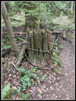 Logging Cable |
 Into The Clearcut |
 Great View Of Baker |
 Zoomed View Of Baker |
 Nice Lighting |
 Baker & Twin Sisters |
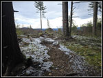
 Old RR Grade Trail |
 Lily Lake Junction |
 Old Trail Sign |
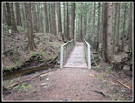 Newer Bridge |
 Near Oyster Dome |
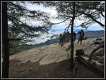 Group At Oyster Dome |
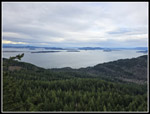 Wide Angle View |
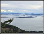 View Southwest |
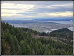 View To Flats |
 Refinery |
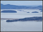 Anacortes |
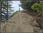 Edge Of Dome |
 North Butte |
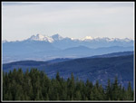 Canadian Peaks |
 Golden Ears |
 Closer Look |
 Heading Back |
 Photogenic |
 First Skunk Cabbage |
 Frozen Pond |
 Lily Lake |
 North Butte View |
 Oyster Dome Below |
 Mt. Baker Cloud Cap |
 Big Boulder |
 Lizard Lake |
 Ice Patterns |
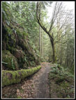
 Lily Lake Trail |
 Underbrush |
 Waterfall |
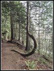 Upside Down ? Tree |
 Great Colors |
Trips - 2024
Home