03-30-24
Gary
was free for a Saturday hike.
The day before was Good Friday and I took advantage of a holiday in my
business for an 8 mile hike with 2800' of elevation gain on Tiger
Mountain. The day before that, Gary did an afternoon/evening hike. We
were both a little tired. This trip is one we tried to do early in the
year and again a week earlier. Things came up and we kept putting it
off. Now was the time. We had been to Baker Vista and found the start
of the trail over to Lost Lake. The route shows up on Gaia GPS maps but
not on official maps. There are no signs at each end. I checked out the
start at Lost Lake last December. Now we just needed to hike the new to
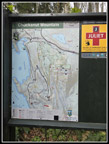
us section. We planned a counterclockwise loop starting at Cyrus Gates
Overlook, going to Fragrance Lake, Burnout Knob, Lost Lake, and
finishing with the Rock Trail. The morning forecast showed overcast sky
going up to over 50% at 9:00 am. We changed plans to a figure eight
route going down the Rock Trail and straight to Baker Vista and Burnout
Knob in just over two miles. With an earlier start, we hoped to get
great views before the clouds rolled in.
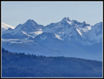
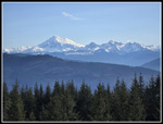
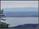
We met at Ash Way P&R at 6:45 am. We reached the Two Dollar Trail on Cleator Road to find the ranger had just opened the gate. It turns out the gate opens at 8:00 am until April 1 when it goes to 6:30 am. We arrived at 7:45 am and the early ranger saved us a 15 minute wait at the gate. We reached the overlook at about 7:55 am. As expected, we were the first car to arrive. The sky was blue on our drive and remained so at the overlook. We had great views out to peaks in Canada. I took some zoomed shots and when I took a look at the photos I could see tall buildings in the fore ground. I believe we were primarily seeing Burnaby, BC near Vancouver. It was just over 40F at the start and with the first mile going downhill we put on an additional layer.
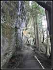
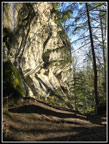
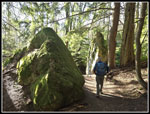
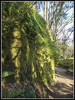
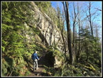
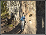
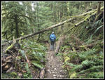
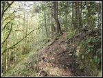
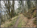
We hit the trail at 8:10 am. The Rock Trail is one of my favorites. Since it opened, I have hiked it at least twice most years. It had taken me hours to reach it. Now it took a couple minutes. Another group of hikers passed us at the staircases. I had a chance to photograph people on the steep stairs. The early start also provided much different light than I had seen on earlier trips. We took fewer photos than usual but I still took a lot. Our desire to get to Baker Vista fast eased at we still had blue sky overhead. The leafless deciduous trees projected shadows on the near vertical sandstone walls providing for some great photos. Below the rock walls we had the fallen boulders covered with moss and licorice ferns. There is a lot to see. Farther down we saw bright yellow skunk cabbage. Trillium and bleeding heart plants were up but not yet blooming. After 1.1 miles, we reached the bottom and turned right on the South Lost Lake Trail.
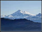
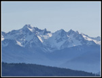
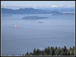
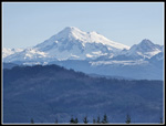
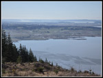
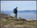
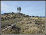
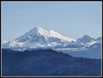
Most of our hikes have a climb up and then a descent back to the start. This trip started at the highest point of the day and alternated ascents and descents all day. The finish was one steady climb up. After dropping down the Rock Trail it was all uphill to Baker Vista. Our figure eight route would end the first loop at the bottom of the Rock Trail. A few hours later we would hike this section of the South Lost Lake Trail a second time. At the next junction we turned left heading for Baker Vista. We turned left on the unsigned logging spur to the vista. It is a really great view of Mt. Baker and the Twin Sisters. Blue sky and low sunshine lit up the peaks without any glare. After we had enough photos we headed back down the spur and then left to Burnout Knob. Now we had great views out to saltwater, the San Juan Islands, Anacortes, the Olympic Mountains and up to Canada. Some thin white clouds were now coming in but we had great conditions. We arrived at Baker Vista at 9:17 am after a 2 mile hike. We spent some time at and around Burnout Knob enjoying the views. From the top of the Knob, we had another view of Mt. Baker. The lighting may have been better this time.
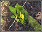
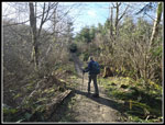
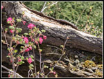
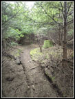
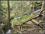
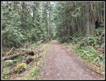
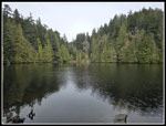
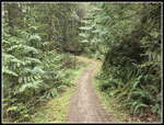
We left the Knob and had a quick hike back to Baker Vista, arriving at 10:14 am. We saw several groups in the Burnout Knob area. We spent nearly an hour at the two viewpoints. Next, we headed down the trail to Lost Lake. This route is used largely by mountain bikers. This day we saw groups of hikers and no bikers on the route. We did not expect to see hikers, especially early in the morning. It has been discovered. The bike route is steep and mostly straight down. We slipped a little but did not fall down. Faster hikers went by several times. The map shows the route crossing roads. I expected to cross clearcuts. That was not the case. It is forested all the way to Lost Lake. There was only one obvious trail junction. The route is to the left. We had already planned to go right first. That dropped us down to what looked like a big pond on the map. It is more of a long narrow pond/swamp. There were few bugs this time of year. It is not a hiking destination. There were some salmonberry bushes starting to leaf out. We managed to find one good flower.
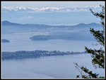
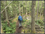
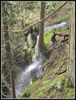
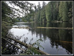
We took a short break and then headed back to the trail. The route heads straight north to Lost Lake. The flattish forest becomes a narrow ridge. The lake will soon fill the gully to the left. On the right the slope steepens to a long drop. It is some neat topography. The lake came into view through the trees. The route has ups and downs alongside the lake. On my December trip I headed south to the outlet on the side of the lake. When the trail dropped all the way to lake level we were at the outlet. I also saw/heard a waterfall a short way down the outlet creek. I tried to get a look at the falls but I was alone on a steep slope and decided wait for a return trip. The outlet crossing was much wider in December. Now it was an easy step across. We met another hiker here going the opposite direction. We explored a faint path alongside the outlet which did provide a bit of a view of the falls. It is a several cascades with the largest only being twenty or so feet tall. It was pretty nonetheless.
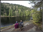
We planned to have lunch at a viewpoint just north of the outlet. We arrived to find hikers already there. We looked for another spot while heading north but did not find one. At the north end of the lake I tried one more time but the spot was not that great. By now the couple at the viewpoint hiked by us and we decided to go back. The spot was just out of sunshine but provides a good look down and out on the lake. It was 11:58 am when we sat down for lunch. The sun was a little muted as very thin clouds were now overhead. We were ready to leave when another group arrived. We hiked around the lake and turned left of the South Lost Lake Trail. This brought us back to the Rock Trail junction for the second time. Along the way we had more skunk cabbage sightings. We saw them in half a dozen spots. We repeated the climb up to the Burnout Knob junction and this time went right. This trail contours around Cyrus Gates Overlook while mostly descending. It is an old road that has narrowed to a trail. We had some views through the trees to saltwater though when the deciduous trees get leaves the views will be lost for the summer.
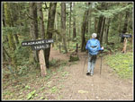
The next junction is where the very steep bike trail crosses our trail. Just after that is the road up to Cleator Road. We met a big bike group here. The road/trail to the right would be our route back but when we reached the trail over to Fragrance Lake we took it. It is a short easy walk to the lake. The trail from Chuckanut Drive is near the start of this trail. That is where the crowds come from. We did see hikers coming and going on this short trail. Nearing the lake, the around the lake trail goes left on a boardwalk/bridge over a wetland. I expected to find a lot of blooming skunk cabbage here. We saw only a few. It was much drier than expected. At the lake we took a short break. We had good views of the lake and saw a retriever dog swimming out for a stick over and over again. We had considered a loop around the lake but after our very recent hikes and today we decided to head back. It was all uphill from the lake. We had 700' to gain over 1.7 miles.
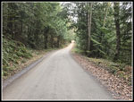
The road/trail was nice walking. We did not see anyone. We reached Cleator Road with .90 miles to go. The road is smooth and gain elevation steadily. I expected to have a stream of cars go by up and down. In fact, we made it to about the last .20 miles seeing only one bicycler. In the last part cars streamed by us. We arrived at Cyrus Gates Overlook at 2:30 pm. The small lot was about full. I went to the viewpoint and took some more photos. With the high white sky the photos were much poorer than they had been in the morning. The statistics of 10.1 miles with 2300' of gain were not that big but after hiking the day before and the uphill finish I was plenty tired.
It took us several tries to get this trip done but it was worth the wait. I always enjoy hiking a new trail. After 42 years it gets more and more difficult to find them on day hikes. The early start and clear sky provided great views and photos. We were early for the wildflower show but the skunk cabbage and salmonberry provided some color. The Rock Trail is always worth the effort. We seldom do figure eight routes which cross in the middle. We saw more people than expected at Burnout Knob and on to Lost Lake. For most of the day we saw hikers periodically but with some long breaks in between. At nearby Oyster Dome we could have seen the same number of people in twenty minutes. This route was not all solitude but we had a lot of it as well. It is the end of March and I am awaiting the high country snow melt but for now this low elevation hike suited us just find.
Click on thumbnails to get
larger pictures.
Trips - 2024
Home
We met at Ash Way P&R at 6:45 am. We reached the Two Dollar Trail on Cleator Road to find the ranger had just opened the gate. It turns out the gate opens at 8:00 am until April 1 when it goes to 6:30 am. We arrived at 7:45 am and the early ranger saved us a 15 minute wait at the gate. We reached the overlook at about 7:55 am. As expected, we were the first car to arrive. The sky was blue on our drive and remained so at the overlook. We had great views out to peaks in Canada. I took some zoomed shots and when I took a look at the photos I could see tall buildings in the fore ground. I believe we were primarily seeing Burnaby, BC near Vancouver. It was just over 40F at the start and with the first mile going downhill we put on an additional layer.
We hit the trail at 8:10 am. The Rock Trail is one of my favorites. Since it opened, I have hiked it at least twice most years. It had taken me hours to reach it. Now it took a couple minutes. Another group of hikers passed us at the staircases. I had a chance to photograph people on the steep stairs. The early start also provided much different light than I had seen on earlier trips. We took fewer photos than usual but I still took a lot. Our desire to get to Baker Vista fast eased at we still had blue sky overhead. The leafless deciduous trees projected shadows on the near vertical sandstone walls providing for some great photos. Below the rock walls we had the fallen boulders covered with moss and licorice ferns. There is a lot to see. Farther down we saw bright yellow skunk cabbage. Trillium and bleeding heart plants were up but not yet blooming. After 1.1 miles, we reached the bottom and turned right on the South Lost Lake Trail.
Most of our hikes have a climb up and then a descent back to the start. This trip started at the highest point of the day and alternated ascents and descents all day. The finish was one steady climb up. After dropping down the Rock Trail it was all uphill to Baker Vista. Our figure eight route would end the first loop at the bottom of the Rock Trail. A few hours later we would hike this section of the South Lost Lake Trail a second time. At the next junction we turned left heading for Baker Vista. We turned left on the unsigned logging spur to the vista. It is a really great view of Mt. Baker and the Twin Sisters. Blue sky and low sunshine lit up the peaks without any glare. After we had enough photos we headed back down the spur and then left to Burnout Knob. Now we had great views out to saltwater, the San Juan Islands, Anacortes, the Olympic Mountains and up to Canada. Some thin white clouds were now coming in but we had great conditions. We arrived at Baker Vista at 9:17 am after a 2 mile hike. We spent some time at and around Burnout Knob enjoying the views. From the top of the Knob, we had another view of Mt. Baker. The lighting may have been better this time.
We left the Knob and had a quick hike back to Baker Vista, arriving at 10:14 am. We saw several groups in the Burnout Knob area. We spent nearly an hour at the two viewpoints. Next, we headed down the trail to Lost Lake. This route is used largely by mountain bikers. This day we saw groups of hikers and no bikers on the route. We did not expect to see hikers, especially early in the morning. It has been discovered. The bike route is steep and mostly straight down. We slipped a little but did not fall down. Faster hikers went by several times. The map shows the route crossing roads. I expected to cross clearcuts. That was not the case. It is forested all the way to Lost Lake. There was only one obvious trail junction. The route is to the left. We had already planned to go right first. That dropped us down to what looked like a big pond on the map. It is more of a long narrow pond/swamp. There were few bugs this time of year. It is not a hiking destination. There were some salmonberry bushes starting to leaf out. We managed to find one good flower.
We took a short break and then headed back to the trail. The route heads straight north to Lost Lake. The flattish forest becomes a narrow ridge. The lake will soon fill the gully to the left. On the right the slope steepens to a long drop. It is some neat topography. The lake came into view through the trees. The route has ups and downs alongside the lake. On my December trip I headed south to the outlet on the side of the lake. When the trail dropped all the way to lake level we were at the outlet. I also saw/heard a waterfall a short way down the outlet creek. I tried to get a look at the falls but I was alone on a steep slope and decided wait for a return trip. The outlet crossing was much wider in December. Now it was an easy step across. We met another hiker here going the opposite direction. We explored a faint path alongside the outlet which did provide a bit of a view of the falls. It is a several cascades with the largest only being twenty or so feet tall. It was pretty nonetheless.
We planned to have lunch at a viewpoint just north of the outlet. We arrived to find hikers already there. We looked for another spot while heading north but did not find one. At the north end of the lake I tried one more time but the spot was not that great. By now the couple at the viewpoint hiked by us and we decided to go back. The spot was just out of sunshine but provides a good look down and out on the lake. It was 11:58 am when we sat down for lunch. The sun was a little muted as very thin clouds were now overhead. We were ready to leave when another group arrived. We hiked around the lake and turned left of the South Lost Lake Trail. This brought us back to the Rock Trail junction for the second time. Along the way we had more skunk cabbage sightings. We saw them in half a dozen spots. We repeated the climb up to the Burnout Knob junction and this time went right. This trail contours around Cyrus Gates Overlook while mostly descending. It is an old road that has narrowed to a trail. We had some views through the trees to saltwater though when the deciduous trees get leaves the views will be lost for the summer.
The next junction is where the very steep bike trail crosses our trail. Just after that is the road up to Cleator Road. We met a big bike group here. The road/trail to the right would be our route back but when we reached the trail over to Fragrance Lake we took it. It is a short easy walk to the lake. The trail from Chuckanut Drive is near the start of this trail. That is where the crowds come from. We did see hikers coming and going on this short trail. Nearing the lake, the around the lake trail goes left on a boardwalk/bridge over a wetland. I expected to find a lot of blooming skunk cabbage here. We saw only a few. It was much drier than expected. At the lake we took a short break. We had good views of the lake and saw a retriever dog swimming out for a stick over and over again. We had considered a loop around the lake but after our very recent hikes and today we decided to head back. It was all uphill from the lake. We had 700' to gain over 1.7 miles.
The road/trail was nice walking. We did not see anyone. We reached Cleator Road with .90 miles to go. The road is smooth and gain elevation steadily. I expected to have a stream of cars go by up and down. In fact, we made it to about the last .20 miles seeing only one bicycler. In the last part cars streamed by us. We arrived at Cyrus Gates Overlook at 2:30 pm. The small lot was about full. I went to the viewpoint and took some more photos. With the high white sky the photos were much poorer than they had been in the morning. The statistics of 10.1 miles with 2300' of gain were not that big but after hiking the day before and the uphill finish I was plenty tired.
It took us several tries to get this trip done but it was worth the wait. I always enjoy hiking a new trail. After 42 years it gets more and more difficult to find them on day hikes. The early start and clear sky provided great views and photos. We were early for the wildflower show but the skunk cabbage and salmonberry provided some color. The Rock Trail is always worth the effort. We seldom do figure eight routes which cross in the middle. We saw more people than expected at Burnout Knob and on to Lost Lake. For most of the day we saw hikers periodically but with some long breaks in between. At nearby Oyster Dome we could have seen the same number of people in twenty minutes. This route was not all solitude but we had a lot of it as well. It is the end of March and I am awaiting the high country snow melt but for now this low elevation hike suited us just find.
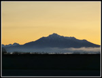 Morning Mt. Pilchuck |
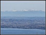 View To Canada |
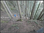 Descending Rock Trail |
 Rock Wall On Rock Trail |
 Tree Shadows |
 Mossy Boulders |
 Ferns On Rock |
 More Shadows |
 Headless Hiker |
 Skunk Cabbage |
 Licorice Ferns |
 Into The Green |
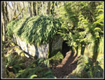 Cave In Rock |
 Trail To Baker View |
 Mt. Baker Viewpoint |
 Red Currants? |
 Twin Sisters |
 Twin Sisters Range |
 Ships At Anchor |
 View Southwest |
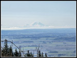 Mt. Rainier |
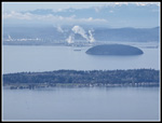 Refineries |
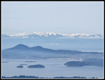 Anacortes & Olympics |
 Baker Again |
 Mt. Baker & Peaks |
 View South |
 Gary At Burnout Knob |
 Leaving Burnout Knob |
 One More Baker Shot |
 On The New Trail |
 A Mushroom |
 On To Lost Lake |
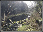 Gary's Swamp |
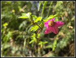 Salmonberry Flower |
 Narrow Ridge |
 Flat Trail |
 Waterfall |
 Cascade & Falls |
 Lost Lake Viewpoint |
 Looking Up Lake |
 Junction Map |
 Heading North |
 Road/Trail |
 Fragrance Lake Trail |
 Fragrance Lake |
 Road/Trail Narrows |
 Cleator Road |
 Overlook View Again |
Trips - 2024
Home