01-01-23
Kim
was free for a New Year's
Day hike. The Huskies were playing in the football semi-final game at
5:30 pm. I had all day for an easy hike. December was crazy as I hiked
12 times in the last 23 days for 113 miles with 27,300' of elevation
gain. I was tired. An easy hike on Cougar Mountain sounded good. We met
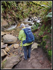
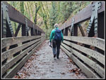
at my home at 8:30 am and headed east. Since Kim had not hiked the Coal
Creek Trail, I decided to park at the start of the trail, just off Coal
Creek Parkway. There were only three or four cars there when we
arrived. It was a chilly 34 degrees when we started out at 9:04 am. The
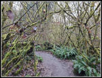
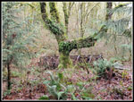
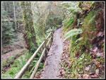
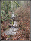
trail begins right alongside the creek. The dark canyon does not get
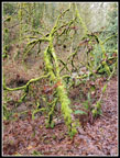
much if any sunshine this time of year. Moss hangs on trees along with
a lot of small ferns. There are many shades of green. That makes for
lots of photos. We were not in a hurry and spent a lot of time finding
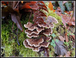
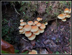
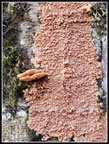
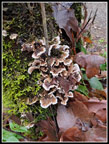
things to photograph. I had not seen fresh mushrooms for several months
until they started to show up again in mid December. We had a good
supply of them this day.
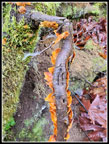
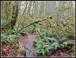
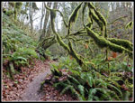
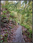
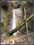
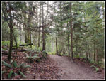
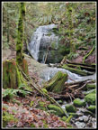
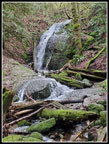
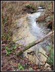
The route has numerous short ups and downs where the creek has no shore and the trail goes up and over humps. Recent rain had created some mud. Neither of us slipped and fell but there were some short steep slick spots. The trail is always interesting. It crosses the creek several times on some short and long bridges. One spot that is right alongside the creek with a steep slope next to it is failing. It is undercut and may fall into the creek in the near term. It is still wide enough to get by safely. We did not see many people early. We saw many more later in the day. At least every other group had a dog or two. The trail reaches a junction. Turning right rises above the creek to a higher bench with meadows and comes near homes. Left on the Primrose Trail drops back to the creek. We stayed by the creek both going up and coming back. There are two waterfalls dropping down to the creek. The first one falls down a sloping rock slab. It was not full but did have plenty of water falling.
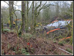
The trail finally starts climbing out of the canyon bottom. It meets up with the other trail and heads up the valley towards Red Town. Some of this is on the old railroad grade from Seattle to Red Town. It shipped many tons of coal to the docks in Seattle. The route grade is low as we headed on. The culvert under the road at Red Town is being replaced with a bridge. The road to Red Town from the north is closed with a sign allowing park access to go around the barrier. I did not know if the Coal Creek Trail was open at the east end. Heavy equipment was parked on the grass. I hoped it was open and we would be able to continue hiking from Red Town to Coal Creek Falls. In the last mile we started to see people hiking in the opposite direction. It looked like the trail still went through to Red Town. The barrier in the road does seem to have reduced parking at Red Town. The two times I was there since the closure, the lots were half full or less on a weekend day.
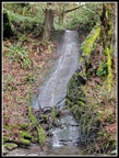
As we neared the east end of the trail, we saw the other waterfall. It was a good flow, though again not like after a good rainstorm. We popped out of the creek canyon to find a walkway across the grass and away from the heavy equipment. The Red Town lot was only about one quarter full. It was now 11:16 am and time for lunch. We had a 15 minute break. I suggested going on to Coal Creek Falls and Kim was agreed. The route up the Cave Hole Road is steep but not too long. We turned right on the Coal Creek Falls Trail. A steady stream of hikers passed us coming out. It must have been really crowded a little earlier. We arrived to find only one person at the falls. The last time I was here in the fall, there was just a little water to be seen. The falls was more like wet moss. Now we had a winter flow. We took photos and enjoyed the view and noise of the rushing water. When the next wave of hikers started to arrive we headed back. It was now 12:13. We still had 4.5 hours until sunset. We soon reached Red Town again.
The hike back to the start was a little faster downhill. We also took fewer photos. We considered taking the upper trail at the junction but decided on the creekside route. It is more enjoyable in my opinion. We reached the parking lot at 2:35 pm. We spent 5.5 hours hiking just over 8 miles with about 1000' of elevation gain. It was a good leg stretcher for Kim and an easy hike for me after the last three weeks of hiking every other day on average. The creek is a nice change from all the Tiger Mountain summits I have been visiting recently. We were home well before dark and I was able to enjoy the Huskies beating Texas and going on to the championship game against Michigan.
Click on thumbnails to get
larger pictures.
Trips - 2024
Home
The route has numerous short ups and downs where the creek has no shore and the trail goes up and over humps. Recent rain had created some mud. Neither of us slipped and fell but there were some short steep slick spots. The trail is always interesting. It crosses the creek several times on some short and long bridges. One spot that is right alongside the creek with a steep slope next to it is failing. It is undercut and may fall into the creek in the near term. It is still wide enough to get by safely. We did not see many people early. We saw many more later in the day. At least every other group had a dog or two. The trail reaches a junction. Turning right rises above the creek to a higher bench with meadows and comes near homes. Left on the Primrose Trail drops back to the creek. We stayed by the creek both going up and coming back. There are two waterfalls dropping down to the creek. The first one falls down a sloping rock slab. It was not full but did have plenty of water falling.
The trail finally starts climbing out of the canyon bottom. It meets up with the other trail and heads up the valley towards Red Town. Some of this is on the old railroad grade from Seattle to Red Town. It shipped many tons of coal to the docks in Seattle. The route grade is low as we headed on. The culvert under the road at Red Town is being replaced with a bridge. The road to Red Town from the north is closed with a sign allowing park access to go around the barrier. I did not know if the Coal Creek Trail was open at the east end. Heavy equipment was parked on the grass. I hoped it was open and we would be able to continue hiking from Red Town to Coal Creek Falls. In the last mile we started to see people hiking in the opposite direction. It looked like the trail still went through to Red Town. The barrier in the road does seem to have reduced parking at Red Town. The two times I was there since the closure, the lots were half full or less on a weekend day.
As we neared the east end of the trail, we saw the other waterfall. It was a good flow, though again not like after a good rainstorm. We popped out of the creek canyon to find a walkway across the grass and away from the heavy equipment. The Red Town lot was only about one quarter full. It was now 11:16 am and time for lunch. We had a 15 minute break. I suggested going on to Coal Creek Falls and Kim was agreed. The route up the Cave Hole Road is steep but not too long. We turned right on the Coal Creek Falls Trail. A steady stream of hikers passed us coming out. It must have been really crowded a little earlier. We arrived to find only one person at the falls. The last time I was here in the fall, there was just a little water to be seen. The falls was more like wet moss. Now we had a winter flow. We took photos and enjoyed the view and noise of the rushing water. When the next wave of hikers started to arrive we headed back. It was now 12:13. We still had 4.5 hours until sunset. We soon reached Red Town again.
The hike back to the start was a little faster downhill. We also took fewer photos. We considered taking the upper trail at the junction but decided on the creekside route. It is more enjoyable in my opinion. We reached the parking lot at 2:35 pm. We spent 5.5 hours hiking just over 8 miles with about 1000' of elevation gain. It was a good leg stretcher for Kim and an easy hike for me after the last three weeks of hiking every other day on average. The creek is a nice change from all the Tiger Mountain summits I have been visiting recently. We were home well before dark and I was able to enjoy the Huskies beating Texas and going on to the championship game against Michigan.
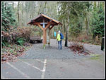 Kim At Trailhead |
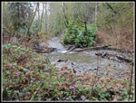 Alongside Coal Creek |
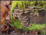
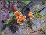 First Turkey Tail Fungus |
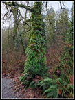 Fern Covered Trees |
 Moss Along Trail |
 Really Mossy |
 Perfect Turkey Tails |
 Some Fungus |
 Fern Tree & Bridge |
 Duck! |
 Very Mossy |
 The First Waterfall |
 Narrow Trail |
 Kim On Trail |
 Mushrooms |
 Creekside Spot |
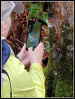 Photo Of Camera |
 Out Of The Canyon |
 Really Nice |
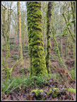 Mossy Tree |
 North Fork Falls |
 Upper Coal Creek |
 Bridge Construction |
 Coal Creek Falls Trail |
 Coal Creek Falls I |
 Coal Creek Falls II |
 Shrooms & Fungus |
 Kim & The Big Bridge |
 Last Fungus |
 Creek Bed Slab |
Trips - 2024
Home