04-06-24
Late
Friday evening the forecast for Saturday was bleak. Rain was to start
at about 10:00 am. I planned an early fast trip up Central Peak on
Squak Mountain. I could ascend and be part way down before the rain
started. I was up at 5:35 am. By 6:00 am I was at my computer. Rain
would be starting sometime after 1:00 pm. That is a lot different than
10:00 am forecast just 6 1/2 hours earlier. Now I had to adjust my
plans. I was still not sure of my trip when I headed east at 6:45 am.
The sky was not pending rain dark so I decided to head to Cougar
Mountain and try to get in a lot of miles. The bridge is still under
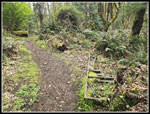
construction so I went around the road closure as the park is open. I
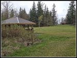
arrived at 7:17 am to find four cars in the lot. The bridge deck frame
is in. I believe it is scheduled to be completed by June. I saw photos
of chocolate lilies at De Leo Wall from just two days earlier. That
would be my first objective. I passed one group immediately and did not
see anyone else for about an hour. I was on my way at 7:21 am. I
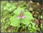
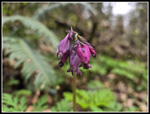
immediately found bleeding hearts in bloom. It would be a while before
I found more. I went by the Ford Slope main mine entrance and onto the
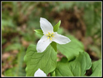
Wildside Trail. This section often has a great early trillium display.
I found trillium but fewer than I expected. Rain overnight and
yesterday had the trillium flowers hanging low. I had a hard time all
day getting a look right at the flowers.
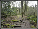
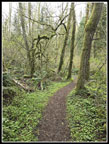
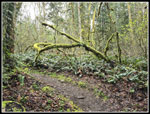
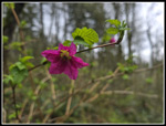
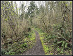
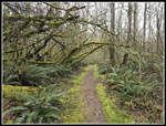
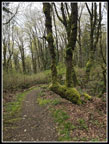
I hiked up Marshall Hill from here once in the 1980s. I had not been on that trail since. I think it is the same trail though I really don't remember much about it. I usually hike to De Leo Wall from the south. This time I would be coming from the north. The junction is well signed. Back in the 1980s there were no houses around here. There was no golf course. There was a landfill and a trail to Old Town Newcastle via China Creek. Now there are houses visible from some of the trail. It is still a very nice trail. There is a lot of moss hanging from trees. I saw some coltsfoot and a few yellow violets. Not a great flower display this early but I did see a good variety of early spring wildflowers. The route crosses a narrow paved road and heads for the top of Marshall Hill. I was glancing at my GPS map but the junctions were obvious. Don't head for nearby houses. One junction had two routes that go to De Leo Wall. I took the left trail that went to the summit. I did not look closely at the map.
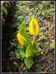
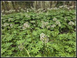
The trail did reach the highest point then began to descend. It seemed to be heading too far south so I checked the map. I managed to completely miss a junction that drops directly to De Leo Wall. It was now shorter to continue dropping to the usual trail I take from the south. I reached that and turned right. I had some unnecessary climbing to get up to the Wall. I arrived and started looking for the chocolate lilies. They really blend in. I often can't see them at all until I see the first one. Then the others magically appear. I tried the first viewpoint and went over to another spot and found nothing. I was really looking carefully. Back at the first spot where I have seen them in other years, I knelt down. I still could not see them. Then I saw one. And another and another. There were at least 7 or 8 in bloom. I have seen dozens at the peak. I may just be a little early. I have a hard time getting a sharp shot of them. The brown and yellow often do not focus well. I took a dozen shots and managed to get a few good ones.
With my detour, I was almost 3 miles into my trip already. I arrived at 8:17 am. I hoped to have at least five hours before the rain arrived so I had time for a big loop trip. There are also fawn lilies near the Wall but I have yet to find one. I headed south and contoured around Marshall Hill. I found more blooming trillium but they were still bent over from rain. I also saw a few more blooming bleeding hearts. I reached the Indian Trail and turned right. Soon I reached the short side trail to Far Country Falls. There was enough water that I could hear it so I went for a visit. Early in the year I was here on a 20F day and ice was everywhere. Now it was just running water. The temperature was in the low to upper 40s this day so no freezing but it was chilly. The falls are not a great scene unless the water is really flowing. It was still worth a look.
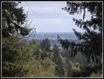
I headed back to the main trail and a few minutes later it was time to turn left on the trail up to Far Country Lookout. I met a running heading in each direction along here. I saw a lot more runners than hikers this day. I hiked up to the viewpoint to find a bit of a view. This was a clearcut in the 1980s with far off views. 35+ years later the trees are now quite tall. I was at a steady 2.8 mph moving speed but the flowers had my overall speed at 2.4 mph. These trails are not steep and I can usually maintain a good pace. Hence my idea of a long hike before the rain arrived. My overall pace was well below what I expected. I passed the lookout, dropped down, and began to climb. I had only a couple trillium sightings before the next junction. My big loop is about 12 miles and with the added trip to De Leo Wall it would be longer. A right at the junction would take me up Deceiver Ridge to Long View Peak and on to Wilderness Peak. Going straight would go through a skunk cabbage march on the Shy Bear Trail and take me to the top of the trail. from there I could go to Wilderness Peak. The skunk cabbage and a shorter route sounded good. I went straight.
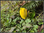
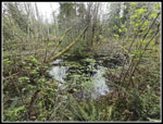
The skunk cabbage was well past prime but I did see some good ones right along the boardwalk through the marsh. I went up then down to a bigger marsh. I could see quite a few yellow skunk cabbage around the other side but that is an off trail route. I decided to pass by this day. I did pretty well seeing skunk cabbage in several places. At the top of the Shy Bear Trail I turned right. This trail took me to Shy Bear Pass. The old trail from the pass to the top of 1595' Wilderness Peak was a steep .40 miles with no switchbacks. The new trail is .60 miles at a much gentler grade. Three groups of runners passed my heading up this section. I arrived at the summit to find five runners milling around. I arrived at 9:59 am. I turned around immediately. Of course, all the runners went by me in the next couple minutes. My GPS showed I had ascended 1425' so far. It is always low. It also give back elevation gain on the way down. Hiking down from Wilderness Peak my elevation gain was reduced by 75' in the first mile. I was almost half way around my loop with 5.7 miles gained to Wilderness Peak. I did see a couple blooming salmonberry flowers below the summit.
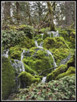
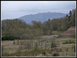
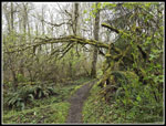
I retraced my route back to the top of the Shy Bear Trail. I continued right on Fred's Railroad. Most of my hikes have a climb on the way up and descent back to the trailhead. This trip had a series of climbs and descents. Now I had a climb to the Clay Pit, a drop to Tibbetts Creek, and a climb to Anti-Aircraft Peak. I turned right from Fred's Railroad onto the East Fork Trail. This took me up to the Clay Pit Road and the Clay Pit. I saw more blooming skunk cabbage on the way. The moist overcast day really had the wet moss glowing. The colors were very vibrant. I took a lot of hanging moss photos this day. At the Clay Pit I saw a group of half a dozen. I could see the tops of Tiger Mountain peaks. There was some fresh snow on top. There was no sign of rain to the east. I took the trail down to Tibbetts Creek and then up to AA Peak. The miles were piling up but I still felt good. My moving speed was still at 2.8 mph but my overall speed was now up to 2.6, I had not taken a break except for the time looking for chocolate lilies.
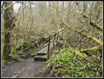
I stopped at the Million Dollar View and could not see much except for Lake Sammamish. I headed over to the first picnic shelter for a food and water break. It was now 11:15 am. I had been hiking for 3:54. I had covered about 10 miles. Now it would be almost all downhill. By 11:21 am I was on my way. I went up to the top of AA Peak and took the Lost Beagle Trail down. There are numerous mossy arches over the trail and I took photos of all of them. I had a steady pace downhill. At the bottom of the trail I turned left on the Klondike Swamp Trail. This took me to the Clay Pit Road once again. I went across and turned onto the Bypass Trail. I quickly reached the Cave Hole Road. For many years this was my route back to the trailhead at Red Town. In recent years, I now take the Nike Horse Trail over to the Sky Country Trailhead and descend from there. It is a bit longer but the trail is much nicer than the old road. When I reached the Sky Country Trailhead I had 1 mile left to Red Town. This went by very fast. I arrived back at the trailhead at 12:30 pm. I saw construction workers at the new bridge site. I have not seen them working on a weekend.
For the day I hiked 13 miles with 2000' of elevation gain. The distance is about 3.5 miles more than my average but the elevation gain was 300' less. This is a long but not steep hike. I was a little disappointed in the number of wildflowers seen but the variety was still good. The parking lot was far from full on my return. I could blame the overcast but that seldom keeps people away from this near to cities park. The NCAA men's final four tournament did start at 12:00 pm so that could also be a reason. I made it home by halftime of the first game. I had a few spits of drizzle on the drive home but not much. What looked to be a very wet day turned out to by very nice.
Click on thumbnails to get
larger pictures.
Trips - 2024
Home
I hiked up Marshall Hill from here once in the 1980s. I had not been on that trail since. I think it is the same trail though I really don't remember much about it. I usually hike to De Leo Wall from the south. This time I would be coming from the north. The junction is well signed. Back in the 1980s there were no houses around here. There was no golf course. There was a landfill and a trail to Old Town Newcastle via China Creek. Now there are houses visible from some of the trail. It is still a very nice trail. There is a lot of moss hanging from trees. I saw some coltsfoot and a few yellow violets. Not a great flower display this early but I did see a good variety of early spring wildflowers. The route crosses a narrow paved road and heads for the top of Marshall Hill. I was glancing at my GPS map but the junctions were obvious. Don't head for nearby houses. One junction had two routes that go to De Leo Wall. I took the left trail that went to the summit. I did not look closely at the map.
The trail did reach the highest point then began to descend. It seemed to be heading too far south so I checked the map. I managed to completely miss a junction that drops directly to De Leo Wall. It was now shorter to continue dropping to the usual trail I take from the south. I reached that and turned right. I had some unnecessary climbing to get up to the Wall. I arrived and started looking for the chocolate lilies. They really blend in. I often can't see them at all until I see the first one. Then the others magically appear. I tried the first viewpoint and went over to another spot and found nothing. I was really looking carefully. Back at the first spot where I have seen them in other years, I knelt down. I still could not see them. Then I saw one. And another and another. There were at least 7 or 8 in bloom. I have seen dozens at the peak. I may just be a little early. I have a hard time getting a sharp shot of them. The brown and yellow often do not focus well. I took a dozen shots and managed to get a few good ones.
With my detour, I was almost 3 miles into my trip already. I arrived at 8:17 am. I hoped to have at least five hours before the rain arrived so I had time for a big loop trip. There are also fawn lilies near the Wall but I have yet to find one. I headed south and contoured around Marshall Hill. I found more blooming trillium but they were still bent over from rain. I also saw a few more blooming bleeding hearts. I reached the Indian Trail and turned right. Soon I reached the short side trail to Far Country Falls. There was enough water that I could hear it so I went for a visit. Early in the year I was here on a 20F day and ice was everywhere. Now it was just running water. The temperature was in the low to upper 40s this day so no freezing but it was chilly. The falls are not a great scene unless the water is really flowing. It was still worth a look.
I headed back to the main trail and a few minutes later it was time to turn left on the trail up to Far Country Lookout. I met a running heading in each direction along here. I saw a lot more runners than hikers this day. I hiked up to the viewpoint to find a bit of a view. This was a clearcut in the 1980s with far off views. 35+ years later the trees are now quite tall. I was at a steady 2.8 mph moving speed but the flowers had my overall speed at 2.4 mph. These trails are not steep and I can usually maintain a good pace. Hence my idea of a long hike before the rain arrived. My overall pace was well below what I expected. I passed the lookout, dropped down, and began to climb. I had only a couple trillium sightings before the next junction. My big loop is about 12 miles and with the added trip to De Leo Wall it would be longer. A right at the junction would take me up Deceiver Ridge to Long View Peak and on to Wilderness Peak. Going straight would go through a skunk cabbage march on the Shy Bear Trail and take me to the top of the trail. from there I could go to Wilderness Peak. The skunk cabbage and a shorter route sounded good. I went straight.
The skunk cabbage was well past prime but I did see some good ones right along the boardwalk through the marsh. I went up then down to a bigger marsh. I could see quite a few yellow skunk cabbage around the other side but that is an off trail route. I decided to pass by this day. I did pretty well seeing skunk cabbage in several places. At the top of the Shy Bear Trail I turned right. This trail took me to Shy Bear Pass. The old trail from the pass to the top of 1595' Wilderness Peak was a steep .40 miles with no switchbacks. The new trail is .60 miles at a much gentler grade. Three groups of runners passed my heading up this section. I arrived at the summit to find five runners milling around. I arrived at 9:59 am. I turned around immediately. Of course, all the runners went by me in the next couple minutes. My GPS showed I had ascended 1425' so far. It is always low. It also give back elevation gain on the way down. Hiking down from Wilderness Peak my elevation gain was reduced by 75' in the first mile. I was almost half way around my loop with 5.7 miles gained to Wilderness Peak. I did see a couple blooming salmonberry flowers below the summit.
I retraced my route back to the top of the Shy Bear Trail. I continued right on Fred's Railroad. Most of my hikes have a climb on the way up and descent back to the trailhead. This trip had a series of climbs and descents. Now I had a climb to the Clay Pit, a drop to Tibbetts Creek, and a climb to Anti-Aircraft Peak. I turned right from Fred's Railroad onto the East Fork Trail. This took me up to the Clay Pit Road and the Clay Pit. I saw more blooming skunk cabbage on the way. The moist overcast day really had the wet moss glowing. The colors were very vibrant. I took a lot of hanging moss photos this day. At the Clay Pit I saw a group of half a dozen. I could see the tops of Tiger Mountain peaks. There was some fresh snow on top. There was no sign of rain to the east. I took the trail down to Tibbetts Creek and then up to AA Peak. The miles were piling up but I still felt good. My moving speed was still at 2.8 mph but my overall speed was now up to 2.6, I had not taken a break except for the time looking for chocolate lilies.
I stopped at the Million Dollar View and could not see much except for Lake Sammamish. I headed over to the first picnic shelter for a food and water break. It was now 11:15 am. I had been hiking for 3:54. I had covered about 10 miles. Now it would be almost all downhill. By 11:21 am I was on my way. I went up to the top of AA Peak and took the Lost Beagle Trail down. There are numerous mossy arches over the trail and I took photos of all of them. I had a steady pace downhill. At the bottom of the trail I turned left on the Klondike Swamp Trail. This took me to the Clay Pit Road once again. I went across and turned onto the Bypass Trail. I quickly reached the Cave Hole Road. For many years this was my route back to the trailhead at Red Town. In recent years, I now take the Nike Horse Trail over to the Sky Country Trailhead and descend from there. It is a bit longer but the trail is much nicer than the old road. When I reached the Sky Country Trailhead I had 1 mile left to Red Town. This went by very fast. I arrived back at the trailhead at 12:30 pm. I saw construction workers at the new bridge site. I have not seen them working on a weekend.
For the day I hiked 13 miles with 2000' of elevation gain. The distance is about 3.5 miles more than my average but the elevation gain was 300' less. This is a long but not steep hike. I was a little disappointed in the number of wildflowers seen but the variety was still good. The parking lot was far from full on my return. I could blame the overcast but that seldom keeps people away from this near to cities park. The NCAA men's final four tournament did start at 12:00 pm so that could also be a reason. I made it home by halftime of the first game. I had a few spits of drizzle on the drive home but not much. What looked to be a very wet day turned out to by very nice.
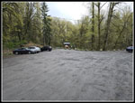 Nearly Empty Lot |
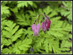 The First Bleeding Hearts |
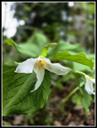 Blooming Trillium |
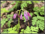 More Bleeding Hearts |
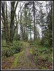 Marshall Hill Trail |
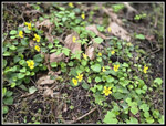 Yellow Violets |
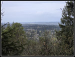 De Leo Wall View |
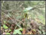 First Chocolate Lily |
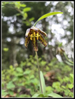 Inside Chocolate Lily |
 More Trillium |
 Way Past Prime |
 Indian Trail? |
 Colorful Bleeding Hearts |
 Far Country Falls |
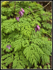 Bunch Of Bleeding Hearts |
 Far Country Lookout |
 Logging Remnants |
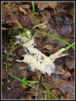 Slime Mold |
 Nice Skunk Cabbage |
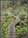 Marsh Boardwalk |
 Brown And Green |
 Moss Along Trail |
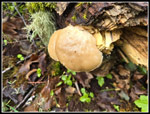 Mushrooms |
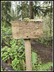 Sign Near Wilderness Peak |
 Salmonberry Flower |
 Nearing Fred's Railroad |
 Another Skunk Cabbage |
 Jerry's Duck Pond |
 Mossy Arbors |
 Coltsfoot |
 Tiger Mt. From Clay Pit |
 Tibbetts Creek Bridge |
 AA Peak Shelters |
 Another Arch |
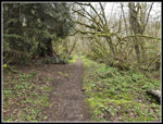 Klondike Swamp Trail |
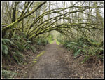 Big Arbors |
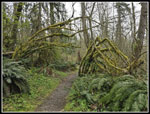 And Another |
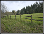 Big Meadow |
 Double Tree |
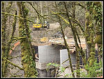 Bridge Construction |
Trips - 2024
Home