01-14-24
After
nearly three days below 32 degrees it looked to warming up just a
little on Sunday. The day before the temperature range in Seattle was
21-16F. That is not normal for Seattle. Add in wind and I stayed home.
This day I was determined to get in a hike. I waited later than usual
to see if it would warm up at all. Originally, I thought about a trip
up Tiger Mountain as it would be partly clear and there was a coating
of snow up there. I checked trip reports and found one for Cougar
Mountain. I saw all the ice in the creeks and waterfalls and recalled
another period of 20F days in 2008. I checked out this old trip report,
Frozen
Tiger Report, and decided to see
if I could have another great photo trip. It was up to 21F when I left
home. There was very little ice on my drive. I pulled into the Red Town
Trailhead at 9:24 am. I put on my winter boots and headed across the
closed road at 9:29 am. The culvert for Coal Creek has been removed and
a bridge is under construction. The first thing I wanted to do was to
drop down Coal Creek to North Fork Falls. This would be the first of
three waterfalls on my route. The first thing I passed was a mine
opening. Inside the opening I found many dozens of big icicles. Some
were up to four feet long. One of the highlights of the day was in the
first ten minutes. I continued down the trail to North Fork Falls.
There was a little ice but it was the least interesting of the three
waterfalls I would see.
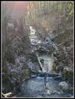
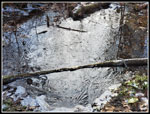
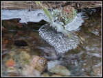
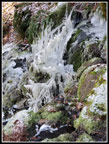
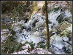
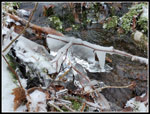
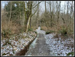
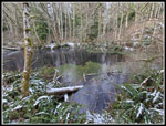
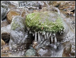
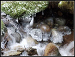
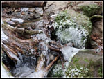
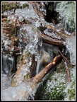
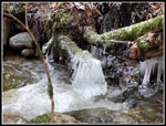
After that, I headed back to the parking lot. I had kicked around a couple possible routes and settled on Far County Lookout to Wilderness Peak via the She Bear Trail and then The Quarry Trail back with a side trip to Coal Creek Falls. I headed out on the Wildside Trail. The ponds near the Ford Slope were all frozen over. Other than running creeks, everything was frozen over. I reached the junction for the Indian Trail. I would be heading that way soon. First, I crossed the bridge over Coal Creek to the Meadow. On my 2008 trip some of the best ice features were along the creek here. I quickly found frozen rocks and low hanging branches that were covered with ice. I knew that the ice would be along streams and that I would be taking most of the photos in these spots. Farther up the creek the right side had easier access to the water so I headed back across the bridge. There were half a dozen spots along the creek with great icy displays. When the road/trail reached the culvert for the creek I found more good spots farther up the creek. After that, I crossed the culvert to access the trail on the other side of the creek heading back down to the meadow. I quickly found that the trail has been obliterated. I headed back the way I came.
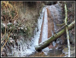
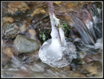
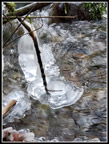
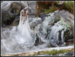
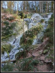
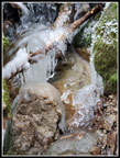
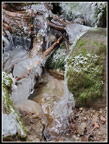
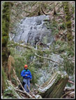
I turned left onto the Indian Trail. There was not much to see along here. I stopped at the old path to the top of Far Country Falls. Before the trail to the base, it was the only way to see the falls. Just like in 2008, there was a lot of ice at the top of the falls and visible at the start of the falls. Some of the ice blobs had grown pretty larch. I headed over to the trail to the base. Two hikers were already there. The falls has minimal water most of the year. Now it had a lot of ice all along the drop. This is the best I have seen it. There was no trail in 2008 so this was by far the most ice I have seen here. I walked back to the Indian Trail and in just a couple minutes I was at the junction with the trail up to Far Country Lookout. I passed the two hikers seen at the falls on the way up. Climbing up seemed to raise the temperature. It was likely in the low 20s by now. I made brief stop at the lookout and headed on. Beyond the lookout the trail drops to a low point then begins to climb. It was more open here and I could see the blue sky. It was very cold but clear.
Soon the trail had a thin coating of trail around it. The trail itself was still mostly bare. On my 2008 trip I turned off on the Deceiver Trail and went to Doughy Falls. This time I stayed straight on the Shy Bear Trail. The route crosses a marsh with lots of bright yellow skunk cabbage in the spring. The boardwalk was slick but has chicken wire on it to provide traction. I filmed a video while hiking across it. There used to be two boardwalks with a slightly muddy section in between. Now there is a new boardwalk. The entire way through the marsh is now raised above the water. The trail climbs then drops to another marsh before the final climb up to meed the end of Fred's Railroad. At that junction I turned right for the .40 mile hike to Shy Bear Pass. This section had a little snow on the trail but it was not at all slick. The old trail from Shy Bear Pass to the top of Wilderness Peak was .40 miles. The new trail is .60 miles. On the trail to the top I saw a couple groups coming down but none going up. I reached the summit at 12:05 pm. Wilderness Peak, at 1598', is the highest point on Cougar Mountain. I had a quick food and water break before heading down. I was right at 5 miles.
I retraced my route back to the junction with the start of Fred's Railroad. I was planning on going down the Quarry Trail. It was early enough to add a little over a mile to get up to 10 miles for the day. I continued past the Quarry Trail to the East Fork Trail. This lead up to the Clay Pit. I zoomed up the trail and continued past the turnaround spot for 10 miles. At Jerry's Duck Pond I continued on the abandoned trail to the upper Clay Pit. I hoped to get a view of Tiger Mountain and some of the Cascades. There are now too many trees along the road down to the lower pit to see anything. I went back for a few photos of the frozen duck pond.
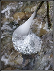
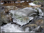
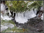
I sped back the way I came. Left on Fred's Railroad and then right onto the Quarry Trail. I followed it down to the short trail to Coal Creek Falls. I was at the falls just two weeks earlier to find a small amount of water coming over the falls. This day it was more but not a lot more. What I did find was a lot of ice in the creek below the falls. Some of the best icy photos were taken here. After that I checked my mileage and found that going back up to the Quarry Trail would add too much mileage I would be up to 11 miles. I had another hike planned for the MLK holiday the next day and chose an easier way back. I followed the usual trail from Red Town to Coal Creek Falls. I saw about half the people for the day in the next half mile. A steady stream were going in and out to the falls. When I reached the Cave Hole Road I decided on one more detour. Instead of descending down to Red Town I headed up hill to add another 150' of elevation gain. Even with this I would only get in 1600' of gain. Where the route leveled off I turned around. Now it was just easy walking downhill to Red Town. I arrive at 2:21 pm. The lot was about 2/3s full. My gps recorded 10.44 miles. It usually reads a little high so 10 miles is a good approximation.
I was very surprised to see that it was 30 degrees at the finish. That is 4 degrees warmer than expected. We almost made it above freezing. I had hoped to get in a great icy hike like in 2008. It was as good as I hoped. My full trip took 4:52 minutes. My moving time was 42 minutes less. I spent a lot of time photographing the icy displays. It was a very cold day and stopping for photos did not help. It was well worth some discomfort to see all that I saw. I would not mind if it takes another decade before we have four or more days in a row from the upper 20s to the mid teens. It does provide some neat things to see though. It was a fun day on the cold trail.
Click on thumbnails to get
larger pictures.
Trips - 2024
Home
After that, I headed back to the parking lot. I had kicked around a couple possible routes and settled on Far County Lookout to Wilderness Peak via the She Bear Trail and then The Quarry Trail back with a side trip to Coal Creek Falls. I headed out on the Wildside Trail. The ponds near the Ford Slope were all frozen over. Other than running creeks, everything was frozen over. I reached the junction for the Indian Trail. I would be heading that way soon. First, I crossed the bridge over Coal Creek to the Meadow. On my 2008 trip some of the best ice features were along the creek here. I quickly found frozen rocks and low hanging branches that were covered with ice. I knew that the ice would be along streams and that I would be taking most of the photos in these spots. Farther up the creek the right side had easier access to the water so I headed back across the bridge. There were half a dozen spots along the creek with great icy displays. When the road/trail reached the culvert for the creek I found more good spots farther up the creek. After that, I crossed the culvert to access the trail on the other side of the creek heading back down to the meadow. I quickly found that the trail has been obliterated. I headed back the way I came.
I turned left onto the Indian Trail. There was not much to see along here. I stopped at the old path to the top of Far Country Falls. Before the trail to the base, it was the only way to see the falls. Just like in 2008, there was a lot of ice at the top of the falls and visible at the start of the falls. Some of the ice blobs had grown pretty larch. I headed over to the trail to the base. Two hikers were already there. The falls has minimal water most of the year. Now it had a lot of ice all along the drop. This is the best I have seen it. There was no trail in 2008 so this was by far the most ice I have seen here. I walked back to the Indian Trail and in just a couple minutes I was at the junction with the trail up to Far Country Lookout. I passed the two hikers seen at the falls on the way up. Climbing up seemed to raise the temperature. It was likely in the low 20s by now. I made brief stop at the lookout and headed on. Beyond the lookout the trail drops to a low point then begins to climb. It was more open here and I could see the blue sky. It was very cold but clear.
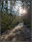
Soon the trail had a thin coating of trail around it. The trail itself was still mostly bare. On my 2008 trip I turned off on the Deceiver Trail and went to Doughy Falls. This time I stayed straight on the Shy Bear Trail. The route crosses a marsh with lots of bright yellow skunk cabbage in the spring. The boardwalk was slick but has chicken wire on it to provide traction. I filmed a video while hiking across it. There used to be two boardwalks with a slightly muddy section in between. Now there is a new boardwalk. The entire way through the marsh is now raised above the water. The trail climbs then drops to another marsh before the final climb up to meed the end of Fred's Railroad. At that junction I turned right for the .40 mile hike to Shy Bear Pass. This section had a little snow on the trail but it was not at all slick. The old trail from Shy Bear Pass to the top of Wilderness Peak was .40 miles. The new trail is .60 miles. On the trail to the top I saw a couple groups coming down but none going up. I reached the summit at 12:05 pm. Wilderness Peak, at 1598', is the highest point on Cougar Mountain. I had a quick food and water break before heading down. I was right at 5 miles.
I retraced my route back to the junction with the start of Fred's Railroad. I was planning on going down the Quarry Trail. It was early enough to add a little over a mile to get up to 10 miles for the day. I continued past the Quarry Trail to the East Fork Trail. This lead up to the Clay Pit. I zoomed up the trail and continued past the turnaround spot for 10 miles. At Jerry's Duck Pond I continued on the abandoned trail to the upper Clay Pit. I hoped to get a view of Tiger Mountain and some of the Cascades. There are now too many trees along the road down to the lower pit to see anything. I went back for a few photos of the frozen duck pond.
I sped back the way I came. Left on Fred's Railroad and then right onto the Quarry Trail. I followed it down to the short trail to Coal Creek Falls. I was at the falls just two weeks earlier to find a small amount of water coming over the falls. This day it was more but not a lot more. What I did find was a lot of ice in the creek below the falls. Some of the best icy photos were taken here. After that I checked my mileage and found that going back up to the Quarry Trail would add too much mileage I would be up to 11 miles. I had another hike planned for the MLK holiday the next day and chose an easier way back. I followed the usual trail from Red Town to Coal Creek Falls. I saw about half the people for the day in the next half mile. A steady stream were going in and out to the falls. When I reached the Cave Hole Road I decided on one more detour. Instead of descending down to Red Town I headed up hill to add another 150' of elevation gain. Even with this I would only get in 1600' of gain. Where the route leveled off I turned around. Now it was just easy walking downhill to Red Town. I arrive at 2:21 pm. The lot was about 2/3s full. My gps recorded 10.44 miles. It usually reads a little high so 10 miles is a good approximation.
I was very surprised to see that it was 30 degrees at the finish. That is 4 degrees warmer than expected. We almost made it above freezing. I had hoped to get in a great icy hike like in 2008. It was as good as I hoped. My full trip took 4:52 minutes. My moving time was 42 minutes less. I spent a lot of time photographing the icy displays. It was a very cold day and stopping for photos did not help. It was well worth some discomfort to see all that I saw. I would not mind if it takes another decade before we have four or more days in a row from the upper 20s to the mid teens. It does provide some neat things to see though. It was a fun day on the cold trail.
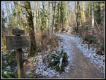
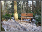
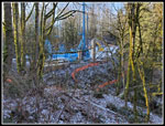 New Bridge Work |
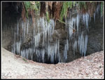 A Wall Of Icicles |
 North Fork Falls |
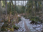
 Coal Creek |
 Icy Pond |
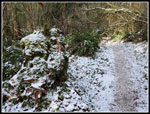
 Wildside Trail |
 Iced Over Stick |
 Ice Blob |
 Neat Patterns |
 Ice Just Above Water |
 All But The Sound |
 Iced Over Rock |
 Top Of FC Falls |
 Start Of Falls |
 Bottom Of FC Falls |
 Green & White |
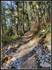
 Shy Bear Trail |
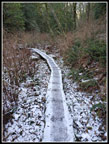 Boardwalk |
 A Little Sunshine |
 Shy Bear Pass |
 Wilderness Peak Summit |
 Snowy Trail |
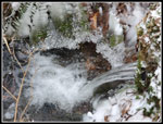 More Ice |
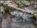 Coal Creek Ice |
 And More Ice |
 On The East Fork Trail |
 Jerry's Duck Pond |
 Ice At Coal Creek Falls |
 Icy Rocks |
 Frozen Falls |
 Icy Blobs |
 A Rare Treat |
 Ice Below Falls |
 Last Creek Ice |
 Coal Creek Falls |
 Ice Sheet |
 Big Tree Near Lot |
Trips - 2024
Home