01-15-24
I
hiked 10 miles the day before
starting out at 16F. Gary and John joined me for a MLK holiday hike. It
would be another cold start but looked to warm up to near freezing
later. We chose a close in hike on Squak Mountain. Gary and John had
both hike up Margaret's Way Trail in the past year. It had been nearly
3 years since my last visit. We were in no hurry to start at the day's
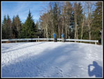
coldest temperature. We met at the Trailhead at 8:55 am. It was 20F per
my car and 19F per John's. Either way, it was cold. The trail does
start climbing quickly helping us warm up. There were only half a dozen
cars in the lot so the holiday hikers were not getting an early start.
It was 9:00 am when we began hiking. We started up the road when I saw
the first change since my last visit. The trail start has been moved.
Now there are two bridges and a set of switchbacks at the beginning.
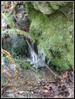
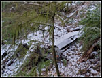
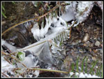
John noticed some icy blobs long the creek. We did not have many icy
features to photograph this day. Yesterday on Cougar Mountain I had a
lot of them.
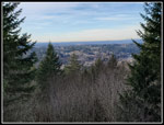
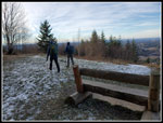
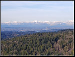
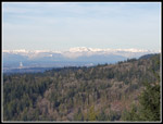
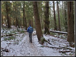
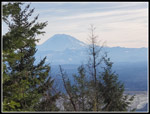
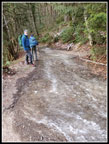
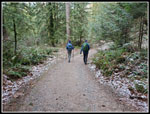
We hiked up through the old campgrounds and back onto a trail. Where an old road comes in we saw three hikers heading up. At this point we had a sheet of ice over the road. There was just enough room to walk on the edge of the road. The ice was thick enough that we could not have stayed upright if we had to walk on it. Soon after this the trail leaves road once and for all. There is a viewpoint just off the trail and we too a look. There was not much to see. A lone hiker passed by us. Back on trail we continued on. The next point of interest is a viewpoint farther off the main trail. We headed out and found some blue sky and some thin white clouds. Mt. Rainier is not in sight from here. What we could see were the Olympic Mountains. Low morning light shone on the peaks. The peaks were lit up from the south end to The Brothers to Mt. Constance and more. The far north was not in sight as Cougar Mountain is in the way. It was warmer up here. The temperature was in the mid 20s. Still very cold but much better than at the start.
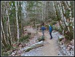
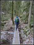
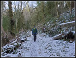
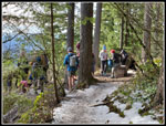
We headed back to the trail. After seeing the new trail at the start, I was interested to see if they had done any work at the big muddy section. When the trail was first opened the mud was extremely deep. Some small reroutes helped but it was still muddy on my last wet season visit. We came to a serious of raised boardwalks that answered my question. It is no problem at all now. Where we crossed the creek we saw some more icy blobs. I stopped for a few photos. The trail now get to work on steadily climbing up to the ridge top ending of Margaret's Way Trail. We saw a couple hikers along here but it was pretty quiet. We new started to see a thin coating of snow along the trail. There was a little on the trail as we ascended. My winter boots are getting older and the traction is okay but much less than when they were new. I was pleased to see I was not slipping at all. We brought along microspikes but never needed them. We reached the top of the trail at 10:31 am. We had hiked 3.4 miles in 1:31.
Right across from us was the Chybinski Trail down the north side of Squak Mountain. We were not sure of our route but were tossing out some ideas. We hiked to the four way intersection ant continued straight towards Debbie's View. We reached th View at 10:39 am. Mt Rainier was very much in sight. The sun was above it so there was a little glare but it was very clear for a day in mid January. We took a short food and water break. It was not crowded for once. We headed back the way we came. We chose not to go over West Peak nor descend the old road. We went back to the Chybinski Trail and headed down the north side. This is as very nice trail. We lost about 400' over 1.3 miles. It is smooth and never steep. Each creek crossing has a bridge. Squak has a lot of steep older trails but this one is very easy on the knees. As we descended the thin snow cover grew even thinner. At the bottom we turned right and in a short distance we met the road that used to be the access to the Bullitt Cabin which is now just the Bullitt Fireplace. This is th appropriately named Bullitt Access Trail.
Part way up we turned left onto the Central Peak Trail. The Bullitt Road/Trail is very wide and rocky. The Central Peak Trail is an old road but much narrower and less rocky. It is more pleasant to hike. I mentioned the old car along the way that I sometimes see and sometimes miss. This time I noticed it. When I started hiking regularly back in the early 1980s, it was not unusual to see old cars or appliances dumped off old logging roads. Most of them have been removed. This is one of the few that is still sitting where it has been for many decades. With snow on top of it, it was hard to see. The trail reached a junction. Right goes to the Bullitt Fireplace. Left goes to Central Peak. We chose to head to the peak. There are a few slippery slabs on the way up but even with a little snow we were fine. We reached the 2019' highest point on Squak Mountain at 12:10 pm. There was now blue sky overhead and the far side of the gravel summit area was in sunshine. We naturally headed for it.
We had traveled 6.5 miles so far. I had hoped for 10 miles but it was clear we would travel farther than that. We really did not need to take a long lunch break. We just knew that this spot was the last place where we would be completely in sunshine on this hike. Two other hikers with a dog joined us. They also headed right towards us to share our small sunny plot of land. They left before us,heading down the road to the state park lot on the south side of Squak. We reluctantly packed up and stated down at 12:48 pm. We decided to take th ridge route over to the Fireplace. As we descended in the forest it quickly became much colder. Gong uphill we had been warm enough. After the sunshine entering cold forest was a little jarring. We took a few photos at the Fireplace and headed down the road. At the Vally Connector Trail junction we turned left. We had one more choice. We could go up and over West Peaks and back to the four way junction in a steep but short distance or go down the Connector Trail to the Perimeter Trail for a longer hiker around the West Peaks. We chose the longer route.
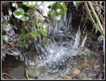
The trail is pretty steep in places. We were a little concerned with traction on the thin snow cover. Once again. traction was great. Where the trail levels off it crosses a creek. It is very muddy on normal above freezing days. After more than three days under 30F it was no problem. There were the best icy blobs of the day however. We tried to get as close to them as possible to take photos. A few minutes later we reached the Perimeter Trail junction. John had not been on the north side trails before and Gary only once with me a year earlier. We all have hiked the Perimeter Trail many times. Gary came up it from the south side just a few weeks earlier. The trail contours around West Peaks at a steady uphill grade. The trail finally leveled off and quickly reached the junction for the spur to Debbie's View. Why not take it once again? There were hikers ahead of us and behind us on this short spur trail. Several groups were also heading out. This did not bode well. We spent about two minutes at the viewpoint. I counted 15 other hikers and with us there were 18 people in a very small area. There was no reason to stay.
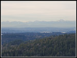
We retraced our steps back to the top of Margaret's Way Trail. This was the third time were there this day. It is very unusual to pass on spot three times on one trip. The sign says it is 2.75 miles back to the start. It is not. Both maps and our gps units showed it to be about 3.3 miles plus detouring to the viewpoint adds another .20. It felt even longer after a full day of hiking. The trip down was uneventful. We did stop at the viewpoint. Now the Olympics were still visible but much less so as the sky was whiter and sun was not shining on them. Morning photos were much better. We reached the parking lot at 3:26 pm. Our trip took 6:26 to cover about 11.8 miles with 2900' of gain. There was only 1600' between the lowest and highest points of the trip and we still managed to gain 2900'. After three trips of 2000' of less to start the year, it was nice to get in more elevation gain. It was up to around the freezing point at the end. Compared to my starts the past two days that felt pretty warm.
MLK Day is a holiday in my business but not in many others. That allows me to hike popular trails with out weekend crowding. Other than near Debbie's View, the trails were not crowded this day. Instead of the usual up on the way in and down gong back, we had three separate climbs on this trip. The sunshine atop Central Peak was very much appreciated as our long lunch stay shows. I will be glad when normal temperatures return and I do not need polypro top and bottom layers. That is a lot of clothing. On the other hand, the much colder temperatures have brought very dry conditions. No umbrellas have been needed. All in all, it was a fine day for a cold but sunny January hike.
Click on thumbnails to get
larger pictures.
Trips - 2024
Home
We hiked up through the old campgrounds and back onto a trail. Where an old road comes in we saw three hikers heading up. At this point we had a sheet of ice over the road. There was just enough room to walk on the edge of the road. The ice was thick enough that we could not have stayed upright if we had to walk on it. Soon after this the trail leaves road once and for all. There is a viewpoint just off the trail and we too a look. There was not much to see. A lone hiker passed by us. Back on trail we continued on. The next point of interest is a viewpoint farther off the main trail. We headed out and found some blue sky and some thin white clouds. Mt. Rainier is not in sight from here. What we could see were the Olympic Mountains. Low morning light shone on the peaks. The peaks were lit up from the south end to The Brothers to Mt. Constance and more. The far north was not in sight as Cougar Mountain is in the way. It was warmer up here. The temperature was in the mid 20s. Still very cold but much better than at the start.
We headed back to the trail. After seeing the new trail at the start, I was interested to see if they had done any work at the big muddy section. When the trail was first opened the mud was extremely deep. Some small reroutes helped but it was still muddy on my last wet season visit. We came to a serious of raised boardwalks that answered my question. It is no problem at all now. Where we crossed the creek we saw some more icy blobs. I stopped for a few photos. The trail now get to work on steadily climbing up to the ridge top ending of Margaret's Way Trail. We saw a couple hikers along here but it was pretty quiet. We new started to see a thin coating of snow along the trail. There was a little on the trail as we ascended. My winter boots are getting older and the traction is okay but much less than when they were new. I was pleased to see I was not slipping at all. We brought along microspikes but never needed them. We reached the top of the trail at 10:31 am. We had hiked 3.4 miles in 1:31.
Right across from us was the Chybinski Trail down the north side of Squak Mountain. We were not sure of our route but were tossing out some ideas. We hiked to the four way intersection ant continued straight towards Debbie's View. We reached th View at 10:39 am. Mt Rainier was very much in sight. The sun was above it so there was a little glare but it was very clear for a day in mid January. We took a short food and water break. It was not crowded for once. We headed back the way we came. We chose not to go over West Peak nor descend the old road. We went back to the Chybinski Trail and headed down the north side. This is as very nice trail. We lost about 400' over 1.3 miles. It is smooth and never steep. Each creek crossing has a bridge. Squak has a lot of steep older trails but this one is very easy on the knees. As we descended the thin snow cover grew even thinner. At the bottom we turned right and in a short distance we met the road that used to be the access to the Bullitt Cabin which is now just the Bullitt Fireplace. This is th appropriately named Bullitt Access Trail.
Part way up we turned left onto the Central Peak Trail. The Bullitt Road/Trail is very wide and rocky. The Central Peak Trail is an old road but much narrower and less rocky. It is more pleasant to hike. I mentioned the old car along the way that I sometimes see and sometimes miss. This time I noticed it. When I started hiking regularly back in the early 1980s, it was not unusual to see old cars or appliances dumped off old logging roads. Most of them have been removed. This is one of the few that is still sitting where it has been for many decades. With snow on top of it, it was hard to see. The trail reached a junction. Right goes to the Bullitt Fireplace. Left goes to Central Peak. We chose to head to the peak. There are a few slippery slabs on the way up but even with a little snow we were fine. We reached the 2019' highest point on Squak Mountain at 12:10 pm. There was now blue sky overhead and the far side of the gravel summit area was in sunshine. We naturally headed for it.
We had traveled 6.5 miles so far. I had hoped for 10 miles but it was clear we would travel farther than that. We really did not need to take a long lunch break. We just knew that this spot was the last place where we would be completely in sunshine on this hike. Two other hikers with a dog joined us. They also headed right towards us to share our small sunny plot of land. They left before us,heading down the road to the state park lot on the south side of Squak. We reluctantly packed up and stated down at 12:48 pm. We decided to take th ridge route over to the Fireplace. As we descended in the forest it quickly became much colder. Gong uphill we had been warm enough. After the sunshine entering cold forest was a little jarring. We took a few photos at the Fireplace and headed down the road. At the Vally Connector Trail junction we turned left. We had one more choice. We could go up and over West Peaks and back to the four way junction in a steep but short distance or go down the Connector Trail to the Perimeter Trail for a longer hiker around the West Peaks. We chose the longer route.
The trail is pretty steep in places. We were a little concerned with traction on the thin snow cover. Once again. traction was great. Where the trail levels off it crosses a creek. It is very muddy on normal above freezing days. After more than three days under 30F it was no problem. There were the best icy blobs of the day however. We tried to get as close to them as possible to take photos. A few minutes later we reached the Perimeter Trail junction. John had not been on the north side trails before and Gary only once with me a year earlier. We all have hiked the Perimeter Trail many times. Gary came up it from the south side just a few weeks earlier. The trail contours around West Peaks at a steady uphill grade. The trail finally leveled off and quickly reached the junction for the spur to Debbie's View. Why not take it once again? There were hikers ahead of us and behind us on this short spur trail. Several groups were also heading out. This did not bode well. We spent about two minutes at the viewpoint. I counted 15 other hikers and with us there were 18 people in a very small area. There was no reason to stay.
We retraced our steps back to the top of Margaret's Way Trail. This was the third time were there this day. It is very unusual to pass on spot three times on one trip. The sign says it is 2.75 miles back to the start. It is not. Both maps and our gps units showed it to be about 3.3 miles plus detouring to the viewpoint adds another .20. It felt even longer after a full day of hiking. The trip down was uneventful. We did stop at the viewpoint. Now the Olympics were still visible but much less so as the sky was whiter and sun was not shining on them. Morning photos were much better. We reached the parking lot at 3:26 pm. Our trip took 6:26 to cover about 11.8 miles with 2900' of gain. There was only 1600' between the lowest and highest points of the trip and we still managed to gain 2900'. After three trips of 2000' of less to start the year, it was nice to get in more elevation gain. It was up to around the freezing point at the end. Compared to my starts the past two days that felt pretty warm.
MLK Day is a holiday in my business but not in many others. That allows me to hike popular trails with out weekend crowding. Other than near Debbie's View, the trails were not crowded this day. Instead of the usual up on the way in and down gong back, we had three separate climbs on this trip. The sunshine atop Central Peak was very much appreciated as our long lunch stay shows. I will be glad when normal temperatures return and I do not need polypro top and bottom layers. That is a lot of clothing. On the other hand, the much colder temperatures have brought very dry conditions. No umbrellas have been needed. All in all, it was a fine day for a cold but sunny January hike.
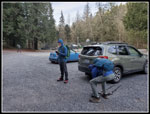 19F Parking Lot |
 A Little Ice |
 First Viewpoint |
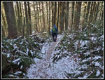
 Gary & Jon On The Trail |
 Second Viewpoint |
 First Olympics View |
 Second Olympics View |
 Long New Boardwalk |
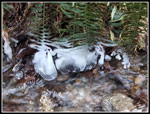 Icy Ferns |
 Snow On Trail |
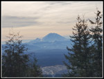 Rainier From Debbie's |
 Guys At Debbie's View |
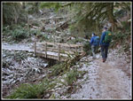 Chybinski Bridge |
 Old Signs |
 Old Car |
 Getting Snowier |
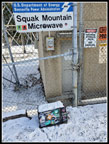 Squak Mt. Microwave |
 In The Sunshine |
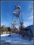 Tower & Blue Sky |
 On Ridge Trail |
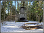 Bullitt Fireplace |
 Nice Ice Blobs |
 Better Ice Blobs |
 Ascending Perimeter Trail |
 More Snow |
 Rainier Again From DV |
 Crowd At D's View |
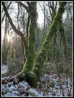 Mossy Trees |
 Second Viewpoint |
 Big Ice Sheet |
 On The Road Again |
 Mossy Rock & Tree |
Trips - 2024
Home