03-16-23
Gary
was open for a hike on Saturday but that changed. I checked options on
Friday night. It would be the warmest day of th year. From high 60s
near the water up to 72 inland. I wanted to get in a long hike. The
mountains had snow recently. I did not to deal with avalanche danger or
soft snow. I settled on Wallace Lake. The lake is at about 1800'. Low
enough to be or nearly be snow free. A trip report from five days
earlier showed some snow at the lake. With the warm day I decided to go
up the Greg Ball trail in forest and come down the DNR Road which is
mostly in the open. The mid to high 60s and sunshine sounded great. I
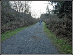
wanted to be on the road by 6:45 am but it was 7:05 when I started.
Nearly every light was red. Traffic was moving below the speed limit. I
was destined to be late. I reached the 350' parking lot at 8:09 am. I
was packed and on my way at 8:14 am. The lot was about half full. It
was sunny but only 36F. The morning called for 15 mph winds gusting to
21 mph and 48F but local weather stations showed mid 20s and no wind.
Without wind 36F was not too bad. I expected it to warm rapidly. Boy
did it. I took the Railroad Grade Trail vs. the Woody Trail as it is
longer and much less crowded. The gentle uphill grade makes or fast
hiking.
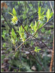
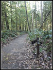
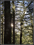
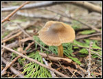
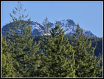
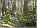
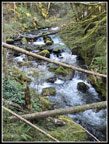
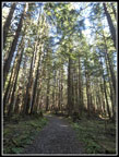
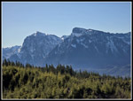
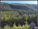
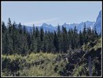
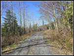
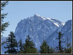
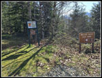
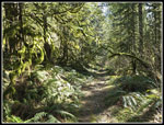
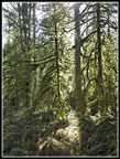
At 1.5 miles I came to the trail that leads to the DNR Road. I would be back at this junction near the end of the day. I passed the two trails that drop to the Woody Trail. The vast majority of hikers would take that trail to the falls. My route took me away from most people. The Railroad Grade ends at 2.4 miles where the Greg Ball Trail takes off. I was almost half way to the lake. I reached that point at 8:58 am. My speed of 3.25 mph was very fast. It would not last. I had some hope of seeing at least one spring wildflower in bloom. I did see exactly one and it was a dandelion. No, that does not count. The dandelion and one mushroom were all I saw. I did see one flowering tree near the start. Spring is not quite here yet. The Greg Ball Trail is a well graded route that consistently gains elevation at a moderate grade. It is not as fast as the Railroad Grade but is still easy hiking. The NF Wallace River was in sight at times. It had a good flow. I saw two people up to the Ball Trail and none on it. My later than normal start did not lead to more hikers on my route.
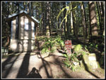
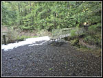
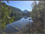
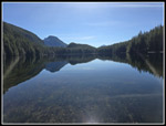
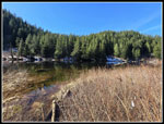
Five days earlier the report mentioned a little snow on the upper GBT. Not now. I reached the DNR Road at 9:51 am. I had 4.4 done before 10:00 am. I turned right on the road and quickly reached the sign stating: "5.9 miles to trailhead via DNR Road". That route adds 1.5 miles to my route up. I was looking to pad the elevation gain as this trip does not reach my average. At the bridge over the NF Wallace River a trail heads for the lake. I crossed the bridge and hiked up a short steep hill to add 50' of gain. I dropped back down and followed the trail .60 miles to Wallace Lake. There was a little snow by and on the bridge over the lake outlet creek. That was it for the hike to the lake. I met a hiker who had come up via the falls. This was his first visit. I took a few photos down the lake trying to see if Pebble Beach was underwater. On recent winter/spring visits the creek/trail to the beach was flowing high and the lake was above beach level. I could not tell from a distance.
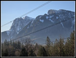
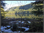
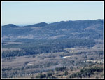
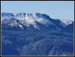
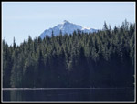
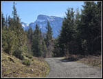
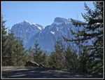
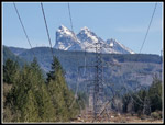
I headed around the lake. The other hiker caught up while I was taking photos. I took him out into the clearcut. He went to the first viewpoint above the Skykomish Valley. I went on and ascended to the upper viewpoint. I have looked southwest before trying to see Seattle. It was never clear enough. This day I did clearly see the Columbia Center and a few other buildings through a low spot in the ridge. I also looked down on part of Wallace Lake. Haystack Ridge is across to the south and it still has a lot of snow on the north side. Up the valley I could see Mts. Index and Persis. I had three viewpoints of these peaks at different points of my trip. It was now getting quite warm. 36F had risen closer to 62F and it felt much warmer in the direct sunshine. I took a food and water break and then just sat in the sunshine admiring the views. I then followed the road to the end a little higher with nice views to the northwest. I descended the road and took a right turn to another viewpoint northwest. Lastly, I headed back an went to the spot the other hikers had seen earlier. I took a video of the peaks and valley. When I watched on my computer screen at home I notice a long train running down below.
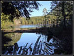
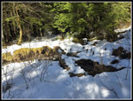
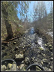
I then headed back to the forest and trail around the side of the lake. My detour added about 1.3 miles with 250' of gain. With the earlier report of snow at Wallace Lake I planned not to go on to Jay Lake. Snow travel is slower and more strenuous and this was already going to be a long trip. As I rounded the lake to the inlet I saw only a few very small snow patches. It was nearly snow free. I stopped at the bench down by the shore. This spot has no sunshine this time of year. I took a few photos and headed on. As mentioned, the inlet creek is the trail to Pebble Beach. Thick brush and sticker bushes guard access to the shore. I found the creek running. It was not deep enough to stop a hiker who did not mind soaking feet. I did mind. I crossed the creek and headed into the brush. I did this route a few years ago. It went fine. I reached the shore where a big log laid. Next to it in the water was a smaller log. Perfect for a seat and footrest. It was much warmer now. I just sat down and enjoyed the view of the lake and the warm sunshine. I could have spent hours there. To my right I could barely see two hikers at Pebble Beach. They likely just walked in the creek. They had solitude and for the most part so did I. I arrived at 11:26. I stayed until 11:41 am. It was not nearly long enough.
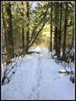
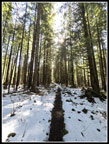
I worked back to the trail. Since I had not seen much snow yet, I decided to hike half way to Jay Lake. That would push my mileage up to 15 miles. Off I went. It is one mile to Jay Lake. There is not much elevation gain. After a quarter mile the trail was lined with snow. Soon it was all snow. I brought gaiter and microspikes just in case. I did not need them. The snow was well packed down. At about this time I ran into the earlier hiker one more time. He had gone on to Jay Lake and was now returning. We talked a little longer and he continued on. Now I thought about going on to the lake. Did I feel like a 16 mile day? I was not sure but I headed on anyway. One bridge was really slick. Otherwise, it was easy walking on the snow. Harder and slower than on dirt but not bad or packed snow. I reached the lake at 12:06 pm. Last fall the lake was so low I walked out far enough to see up and down the whole lake. This time that spot was underwater. The high brush did not yet have leaves so I had a kind of view of some of the lake. I had one more food and water break then headed back. I made it back to Wallace Lake at 12:29 pm. I had no interest in Pebble Beach this day.
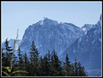
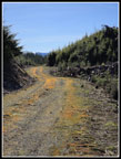
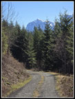
I zipped on around the lake, reaching the outlet at 12:43 pm. Now I had about 6.6 miles to go. Hiking back to the DNR Road I saw several groups hiking in. The shortest route to Wallace Lake is about 4.1 miles. It was still plenty early for folks on their way. At the road I turned right. I quickly reached the 5.9 mile sign and then the top of the Greg Ball Trail. A sign stated it was 4.2 miles down via the GBT and the Railroad Grade Trail and only 3.4 via the GBT and Woody Trail. I was still feeling well enough for the 5.9 mile DNR Road and RR Grade route. It was now getting toasty warm. It is still mid March and technically winter. 70F days are rare. I planned this route so I would have sunshine on the road coming down. On the 3.5 miles of road I saw one biker coming uphill. That was it. Once into the clearcuts it as very sunny and very warm. I made good time on the road section, Down near the quarry, views open up to Mts. Index and Persis once again. I took quite a few photos. Near the end of the road section I was looking forward to the cool forest once again. 67F was feeling very warm. That is because it was not 67F.
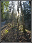
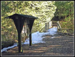
I left the road and entered forest with 2.4 miles to go. I had covered 13.6 miles. My new phone GPS often read higher than known distances. This day it was exactly recording the distances between mile markers. I feel pretty confident that it was a full 16 miles. I reached the Railroad Grade Trail with 1.5 miles to go. That first and last 1.5 miles is all that I repeated. Even in the forest it was feeling hot. Mid March in Western Washington? I reached the new packed trailhead at 2:58 pm. I was beat. As I drove out there was the usual long line of cars parked on the side/in the road. Alongside the lower road was a lot of heavy equipment and bare ground. It looks like there will be a housing development there soon.
My car registered 75 degrees at the parking lot. It only went up from there. The high was 79 in Monroe. I am just now checking the highest recorded temperature for March 16 in Seattle. That was 70F in 1947. It was 74 when I arrived home at 4:50 pm. I was prepared for two hours in 67F sunshine coming down the DNR Road but not 75F Well, my winter pasty white skin is looking a little redder the next day. All in all, it was a very nice day for a long hike. I had views and lakes and not a lot of company. I had the warmest March 16 in recorded history. Now we just have four more days of winter to go.
Click on thumbnails to get
larger pictures.
Trips - 2024
Home
At 1.5 miles I came to the trail that leads to the DNR Road. I would be back at this junction near the end of the day. I passed the two trails that drop to the Woody Trail. The vast majority of hikers would take that trail to the falls. My route took me away from most people. The Railroad Grade ends at 2.4 miles where the Greg Ball Trail takes off. I was almost half way to the lake. I reached that point at 8:58 am. My speed of 3.25 mph was very fast. It would not last. I had some hope of seeing at least one spring wildflower in bloom. I did see exactly one and it was a dandelion. No, that does not count. The dandelion and one mushroom were all I saw. I did see one flowering tree near the start. Spring is not quite here yet. The Greg Ball Trail is a well graded route that consistently gains elevation at a moderate grade. It is not as fast as the Railroad Grade but is still easy hiking. The NF Wallace River was in sight at times. It had a good flow. I saw two people up to the Ball Trail and none on it. My later than normal start did not lead to more hikers on my route.
Five days earlier the report mentioned a little snow on the upper GBT. Not now. I reached the DNR Road at 9:51 am. I had 4.4 done before 10:00 am. I turned right on the road and quickly reached the sign stating: "5.9 miles to trailhead via DNR Road". That route adds 1.5 miles to my route up. I was looking to pad the elevation gain as this trip does not reach my average. At the bridge over the NF Wallace River a trail heads for the lake. I crossed the bridge and hiked up a short steep hill to add 50' of gain. I dropped back down and followed the trail .60 miles to Wallace Lake. There was a little snow by and on the bridge over the lake outlet creek. That was it for the hike to the lake. I met a hiker who had come up via the falls. This was his first visit. I took a few photos down the lake trying to see if Pebble Beach was underwater. On recent winter/spring visits the creek/trail to the beach was flowing high and the lake was above beach level. I could not tell from a distance.
I headed around the lake. The other hiker caught up while I was taking photos. I took him out into the clearcut. He went to the first viewpoint above the Skykomish Valley. I went on and ascended to the upper viewpoint. I have looked southwest before trying to see Seattle. It was never clear enough. This day I did clearly see the Columbia Center and a few other buildings through a low spot in the ridge. I also looked down on part of Wallace Lake. Haystack Ridge is across to the south and it still has a lot of snow on the north side. Up the valley I could see Mts. Index and Persis. I had three viewpoints of these peaks at different points of my trip. It was now getting quite warm. 36F had risen closer to 62F and it felt much warmer in the direct sunshine. I took a food and water break and then just sat in the sunshine admiring the views. I then followed the road to the end a little higher with nice views to the northwest. I descended the road and took a right turn to another viewpoint northwest. Lastly, I headed back an went to the spot the other hikers had seen earlier. I took a video of the peaks and valley. When I watched on my computer screen at home I notice a long train running down below.
I then headed back to the forest and trail around the side of the lake. My detour added about 1.3 miles with 250' of gain. With the earlier report of snow at Wallace Lake I planned not to go on to Jay Lake. Snow travel is slower and more strenuous and this was already going to be a long trip. As I rounded the lake to the inlet I saw only a few very small snow patches. It was nearly snow free. I stopped at the bench down by the shore. This spot has no sunshine this time of year. I took a few photos and headed on. As mentioned, the inlet creek is the trail to Pebble Beach. Thick brush and sticker bushes guard access to the shore. I found the creek running. It was not deep enough to stop a hiker who did not mind soaking feet. I did mind. I crossed the creek and headed into the brush. I did this route a few years ago. It went fine. I reached the shore where a big log laid. Next to it in the water was a smaller log. Perfect for a seat and footrest. It was much warmer now. I just sat down and enjoyed the view of the lake and the warm sunshine. I could have spent hours there. To my right I could barely see two hikers at Pebble Beach. They likely just walked in the creek. They had solitude and for the most part so did I. I arrived at 11:26. I stayed until 11:41 am. It was not nearly long enough.
I worked back to the trail. Since I had not seen much snow yet, I decided to hike half way to Jay Lake. That would push my mileage up to 15 miles. Off I went. It is one mile to Jay Lake. There is not much elevation gain. After a quarter mile the trail was lined with snow. Soon it was all snow. I brought gaiter and microspikes just in case. I did not need them. The snow was well packed down. At about this time I ran into the earlier hiker one more time. He had gone on to Jay Lake and was now returning. We talked a little longer and he continued on. Now I thought about going on to the lake. Did I feel like a 16 mile day? I was not sure but I headed on anyway. One bridge was really slick. Otherwise, it was easy walking on the snow. Harder and slower than on dirt but not bad or packed snow. I reached the lake at 12:06 pm. Last fall the lake was so low I walked out far enough to see up and down the whole lake. This time that spot was underwater. The high brush did not yet have leaves so I had a kind of view of some of the lake. I had one more food and water break then headed back. I made it back to Wallace Lake at 12:29 pm. I had no interest in Pebble Beach this day.
I zipped on around the lake, reaching the outlet at 12:43 pm. Now I had about 6.6 miles to go. Hiking back to the DNR Road I saw several groups hiking in. The shortest route to Wallace Lake is about 4.1 miles. It was still plenty early for folks on their way. At the road I turned right. I quickly reached the 5.9 mile sign and then the top of the Greg Ball Trail. A sign stated it was 4.2 miles down via the GBT and the Railroad Grade Trail and only 3.4 via the GBT and Woody Trail. I was still feeling well enough for the 5.9 mile DNR Road and RR Grade route. It was now getting toasty warm. It is still mid March and technically winter. 70F days are rare. I planned this route so I would have sunshine on the road coming down. On the 3.5 miles of road I saw one biker coming uphill. That was it. Once into the clearcuts it as very sunny and very warm. I made good time on the road section, Down near the quarry, views open up to Mts. Index and Persis once again. I took quite a few photos. Near the end of the road section I was looking forward to the cool forest once again. 67F was feeling very warm. That is because it was not 67F.
I left the road and entered forest with 2.4 miles to go. I had covered 13.6 miles. My new phone GPS often read higher than known distances. This day it was exactly recording the distances between mile markers. I feel pretty confident that it was a full 16 miles. I reached the Railroad Grade Trail with 1.5 miles to go. That first and last 1.5 miles is all that I repeated. Even in the forest it was feeling hot. Mid March in Western Washington? I reached the new packed trailhead at 2:58 pm. I was beat. As I drove out there was the usual long line of cars parked on the side/in the road. Alongside the lower road was a lot of heavy equipment and bare ground. It looks like there will be a housing development there soon.
My car registered 75 degrees at the parking lot. It only went up from there. The high was 79 in Monroe. I am just now checking the highest recorded temperature for March 16 in Seattle. That was 70F in 1947. It was 74 when I arrived home at 4:50 pm. I was prepared for two hours in 67F sunshine coming down the DNR Road but not 75F Well, my winter pasty white skin is looking a little redder the next day. All in all, it was a very nice day for a long hike. I had views and lakes and not a lot of company. I had the warmest March 16 in recorded history. Now we just have four more days of winter to go.
 Starting Out |
 Mt. Index & Persis |
 The Only Bloom Seen |
 Low Sun Ahead |
 1.5 Miles Done |
 Lit Up Moss |
 End Of RR Grade |
 A Mushroom |
 Snowy Peaks |
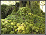
 Mossy Ground Cover |
 NF Wallace River |
 Top Of Greg Ball Trail |
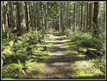
 Wide Angle Forest |
 Wallace Lake Outlet |
 Lake From Outlet |
 Wallace Lake Reflection |
 Peaks From Clearcut |
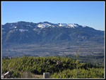 Haystack Ridge |
 Wallace Lake Below |
 Mt. Index From Ridge |
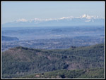 The Olympic Mountains |
 Downtown Seattle |
 Road To Ridge Top |
 Colorful Road |
 Peaks To The East |
 At Wallace Lake |
 Near Pebble Beach |
 Index Over Wallace Lake |
 Miniature Forest |
 Bare Trail To Jay Lake |
 Snowy Trail To Jay Lake |
 Icy Bridge |
 Jay Lake |
 Snow Lined Trail |
 Wallace Lake Inlet Creek |
 Back At Outlet |
 On DNR Road |
 View Of Mt. Index |
 Mt. Persis In Sight |
 Index & Persis From Road |
 Index Close Up |
 Into The Forest |
 Mossy Arch |
 Sun Lit Moss |
 Grassy Switchback |
 Mt. Baring |
Trips - 2024
Home