04-19-25
I
planned a trip near Cle Elum. The forecast gusts up to 30mph were a bit
much. Especially for a flower photography hike. I doubt it was anywhere
near that bad but I chose to head north to find blue sky and sunshine.
I did a part of this hike several weeks ago. I had not done the ridge
hike in 1.5 years. I was out the door at 6:35 am. I needed to get gas
on the way and that took a little time. I reached the North Chuckanut
Trailhead right on Chuckanut Drive at 8:14 am. At 47F it was
cool but not cold. No gloves were needed. There were 7-8 cars by the
road but only half a dozen in the lot. I was on my way at 8:18 am. The
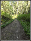
trail first has a short climb up to the Interurban Trail. It is an
passenger rail grade that went to Mt. Vernon. Along the way, I saw
blooming salmonberry, bleeding hearts, and skunk cabbage. The skunk
cabbage was a bit past prime the others were looking very good. I
turned left on the grade and continued. There is a small waterfall next
to the trail. It washed out a few years back. A bridge was put in. Now
there are two.
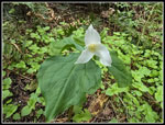
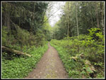
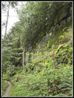
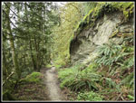
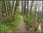
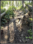
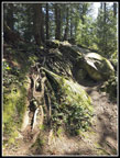
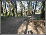
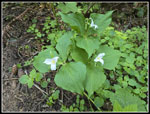
In time I took a right turn and began to climb on the Hemlock Trail.. This trail is well used by mountain bikers. The grade is moderate and the trail is smooth. I made good time on the ascent. I went right again on the Lost Lake Trail. I had not yet decided whether to do the big loop part of the trip clockwise or counterclockwise. It was much more overcast than predicted. Going counterclockwise takes you up to a view of Mt. Baker early in the trip. Going clockwise means a long trip below the ridge with no views until reaching Cyrus Gates Overlook at the highest point on the ridge. With the morning overcast I was now leaning on doing the lowlands first and hoping for a clearing in the afternoon. I reached the junction for the loop at 9:05 am. I had covered 2.2 miles in 47 miles while gaining 1040' net. I added quite a few blooming trillium to the flower display. It had warmed up enough that I zipped off my pants legs and put on a short sleeve shirt. I decided on the clockwise loop. The Lost Lake Trail is an old roadbed with some gravel and grass. I had forest on both sides and the ridge I would later hike down was rising above me on the right. The rock on this ridge wall is all sandstone. I had some great vertical wall sections along the way.
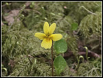
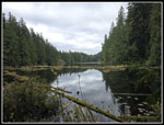
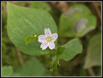
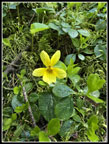
I continued to ascend for a while before the grade flattened. I now saw some yellow violets mixed in with more skunk cabbage and trillium. I had another 2.4 miles from the loop junction to the turnoff for Lost Lake. I saw only a few runners occasionally. Western Washington University is not far away and I expect to see lots of college aged kids out running or hiking. A few spots were really muddy where water ran down the trail with lots of deep bike tire tracks. Most of the way was dry and fine. I stopped at the thin waterfall coming down off the ridge next to the trail. It has little flow much of the year. but in winter and spring it can run pretty well. I reached the 4.6 mile junction at 9:59 am. My time of 1:41 mostly uphill with a lot of photos stops was pretty good. My overall pace was about to crater. There was much to see for the next few hours and not much territory was covered. The "trail" around the end of Lost Lake is really muddy this time of year. I went towards the lake and crawled over a few big logs but avoided the muck. I poked through the trees for a good look down the length of this long narrow lake. The lake was too high to get beyond the trees for a better view. The grass was partly underwater. I continued around the lake and then a short steep uphill put me on the narrow ridge that goes alongside the lake. Only at the mid-lake outlet does it drop to lake level.
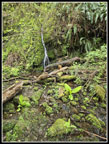
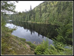
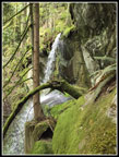
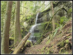
I was here three weeks earlier on a much different loop hike. That one was two loops making for a figure eight course. I hiked along the trail to the rock slab where I took a break. This was filled with people on my previous two visits. I was early enough in the day to have the spot to myself. There were now a few blue spots overhead though it was still mostly overcast. I had a good look out to the lake. It is about a 20' drop directly down to the lake. Some food and water and photos and I was ready to get moving after about 10 minutes. The outlet creek quickly drops over a cliff. You can hear the waterfall well before reaching it. On two previous trips I had tried to get down far enough to look up at the falls. There is a cliff band in the way. Last time Gary and I did get down to the top of the cliffs ford a look across at the falls from just below the top. In the meantime, an online friend had posted photos of the falls from down below. If Lauren made it down I should be able to also. I decided to give it another try.
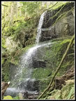
There is a boot path that starts down the slope. It soon disappears. I went away from the falls and found a spot where I could drop down a short way to the bottom of the cliff band. I walked right along the edge on a ramp that brought me back to the falls. I had fun taking photos, videos, and slow motion videos. The lake was lower than three weeks earlier and the outlet creek was smaller. I need to come back earlier next year to see the falls at full size. It was still worth the effort to find. It is a reasonable scramble but definitely not an easy trail. Many folks will not be comfortable with the route. I headed back up to the real trail at the outlet. I could see that the outlet flow was much less then three weeks earlier. I started back at 10:36 am. In the 37 minutes since I started looking for the falls I covered very little distance. I retraced my route back to the Lost Lake Trail junction. I found a few blooming skunk cabbage in the mucky mire but much fewer than three weeks earlier.
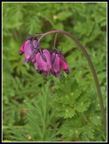
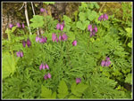
At the junction I turned left and headed for the bottom of the Rock Trail. I saw a few very nice displays of blooming trillium and a false Solomon's seal about to bloom. I reached the Rock Trail at 11:00 am. I had seem several more runners and a hiker on the last section. I expected to see people on the Rock Trail and I did. You can drive to Cyrus Gates Overlook and hike a mile downhill to reach this spot which I had hiked 2:42 to reach from the North Chuckanut Trailhead. I was just about half way through my 12 mile trip and had gained half the elevation. We had very few flowers on the Rock Trail when we descended it three weeks earlier. It had changed. The lower part had a lot of colors. The bleeding hearts were by far the most prolific. Big patches were on both sides of the trail. The light pink flowers are very hard to focus on. The darker purple ones were much better. I still had a lot of blurry photos but compared to the past few weeks I had a lot of very sharp ones too. I was moving very slowly along here. Soon I was also seeing trillium in bloom. A few muddy spots had some more skunk cabbage too.
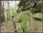
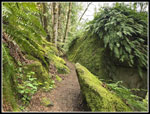
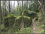
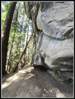
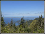
When the flowers began to wane the sandstone rock display picked up. Lower down there are many big boulders that have fallen off the near vertical walls. They are mostly covered with moss and small ferns. It is a terrific display. The lighting was excellent. It was still mostly cloudy but with bigger patches of blue. I had some lit up spots and some shady spots too. I don't think I have ever exceeded one mile per hour on this trail. I did not do so this day. There was less water running down the lichen stained walls than before but it was still very scenic. I finally climbed the eight or so sets of steps up the very steep slope to the top. I was then just a few minutes away from Cyrus Gates Overlook. I arrived at 11:42 am, just in time for lunch. There was one other group there and the small lot was mostly full. It was much hazier than the previous visit and buildings in the Vancouver, BC area were not visible. I was about 7 miles in and I still had the 3 mile long ridge trail to close my loop then 2.2 miles back to the trailhead.
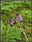
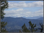
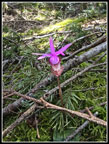
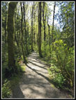
I have a love/hate relationship with the Ridge Trail. It is a challenging hike that is always much longer than I think. There are numerous ups and downs with some rocks and slabs to negotiate. I was starting at the higher end so that was good but I was also tired from the morning hiking. I was on my way at 11:52 am. You can hike short way above the Overlook to the top of the ridge and then follow a steep rocky trail down the ridge. This day I chose to just walk the road for a few minutes to reach the trail on the ridge top. There is a view of Mt. Baker from there. I took a look and found that only the very base was visible. Oh well, not today. I met a hiker coming up almost immediately. I saw only a couple other groups on the ridge. I did see some trillium and yellow violets plus lots or shelf fungus on the ridge.That was it except for one really need mushroom. The Ridge Trail was its usual frustrating yet fun hike. One of the nearly straight up climbs was 150' to the top. I gained about 700' of elevation while hiking down the ridge. As I said, there were many ups and downs. Part way along I saw something colorful out of the corner of my eye. I stopped and looked down to find a single calypso orchid in full bloom. The bright pink flower was on a bed of green moss. They are only about 3" tall. They are that same color which makes auto focus mostly not possible. I took at least 20 photos to get just a couple that were sharp. Two runners saw this big guy on his knees with his camera right at ground level and kept on running.
I was on the lookout for more and I did find four more. That was it. This seems pretty early for calypso orchids. I was pleased to have seen them. I also stopped to see the before mentioned neat mushroom. At the end of the forested ridge there are a few spots with views to the east where Mt. Baker can often be seen. It was better than at the other end of the ridge but the top was blocked by some low clouds in the near distance. The trail then drops steeply and cuts across the very steep nose of the ridge. I popped out of the forest at the 2.2 mile spot to complete my loop. The last section back to the car went by quickly as I was able to really pick up my pace. I took a few photos but far fewer than in the morning on the way up. I arrived back at my car at 2:16 pm. I spent 5:58 on the trail hiking 12 miles with 2700' of gain. This was my fourth consecutive trip with between 10 and 17 miles hiked. That adds up to 53 miles in 15 days. That is not a bad start for spring.
This turned out to be a memorable hike for several reasons. The flower display was excellent. The Rock Trail is always a treat. The Ridge Trail is fun too. The best part was finally getting to the bottom of the falls coming out of Lost Lake. The drive home had the usual construction and weekend traffic fun but I was home by about 4:20 pm. Not bad for a 165 mile drive and a 12 mile hike. There are enough trails on Blanchard Hill/Chuckanut Mt. to allow for half a dozen trips each year without even repeating the same track. I have certainly come to enjoy it.
Click on thumbnails to get
larger pictures.
Trips - 2025
Home
In time I took a right turn and began to climb on the Hemlock Trail.. This trail is well used by mountain bikers. The grade is moderate and the trail is smooth. I made good time on the ascent. I went right again on the Lost Lake Trail. I had not yet decided whether to do the big loop part of the trip clockwise or counterclockwise. It was much more overcast than predicted. Going counterclockwise takes you up to a view of Mt. Baker early in the trip. Going clockwise means a long trip below the ridge with no views until reaching Cyrus Gates Overlook at the highest point on the ridge. With the morning overcast I was now leaning on doing the lowlands first and hoping for a clearing in the afternoon. I reached the junction for the loop at 9:05 am. I had covered 2.2 miles in 47 miles while gaining 1040' net. I added quite a few blooming trillium to the flower display. It had warmed up enough that I zipped off my pants legs and put on a short sleeve shirt. I decided on the clockwise loop. The Lost Lake Trail is an old roadbed with some gravel and grass. I had forest on both sides and the ridge I would later hike down was rising above me on the right. The rock on this ridge wall is all sandstone. I had some great vertical wall sections along the way.
I continued to ascend for a while before the grade flattened. I now saw some yellow violets mixed in with more skunk cabbage and trillium. I had another 2.4 miles from the loop junction to the turnoff for Lost Lake. I saw only a few runners occasionally. Western Washington University is not far away and I expect to see lots of college aged kids out running or hiking. A few spots were really muddy where water ran down the trail with lots of deep bike tire tracks. Most of the way was dry and fine. I stopped at the thin waterfall coming down off the ridge next to the trail. It has little flow much of the year. but in winter and spring it can run pretty well. I reached the 4.6 mile junction at 9:59 am. My time of 1:41 mostly uphill with a lot of photos stops was pretty good. My overall pace was about to crater. There was much to see for the next few hours and not much territory was covered. The "trail" around the end of Lost Lake is really muddy this time of year. I went towards the lake and crawled over a few big logs but avoided the muck. I poked through the trees for a good look down the length of this long narrow lake. The lake was too high to get beyond the trees for a better view. The grass was partly underwater. I continued around the lake and then a short steep uphill put me on the narrow ridge that goes alongside the lake. Only at the mid-lake outlet does it drop to lake level.
I was here three weeks earlier on a much different loop hike. That one was two loops making for a figure eight course. I hiked along the trail to the rock slab where I took a break. This was filled with people on my previous two visits. I was early enough in the day to have the spot to myself. There were now a few blue spots overhead though it was still mostly overcast. I had a good look out to the lake. It is about a 20' drop directly down to the lake. Some food and water and photos and I was ready to get moving after about 10 minutes. The outlet creek quickly drops over a cliff. You can hear the waterfall well before reaching it. On two previous trips I had tried to get down far enough to look up at the falls. There is a cliff band in the way. Last time Gary and I did get down to the top of the cliffs ford a look across at the falls from just below the top. In the meantime, an online friend had posted photos of the falls from down below. If Lauren made it down I should be able to also. I decided to give it another try.
There is a boot path that starts down the slope. It soon disappears. I went away from the falls and found a spot where I could drop down a short way to the bottom of the cliff band. I walked right along the edge on a ramp that brought me back to the falls. I had fun taking photos, videos, and slow motion videos. The lake was lower than three weeks earlier and the outlet creek was smaller. I need to come back earlier next year to see the falls at full size. It was still worth the effort to find. It is a reasonable scramble but definitely not an easy trail. Many folks will not be comfortable with the route. I headed back up to the real trail at the outlet. I could see that the outlet flow was much less then three weeks earlier. I started back at 10:36 am. In the 37 minutes since I started looking for the falls I covered very little distance. I retraced my route back to the Lost Lake Trail junction. I found a few blooming skunk cabbage in the mucky mire but much fewer than three weeks earlier.
At the junction I turned left and headed for the bottom of the Rock Trail. I saw a few very nice displays of blooming trillium and a false Solomon's seal about to bloom. I reached the Rock Trail at 11:00 am. I had seem several more runners and a hiker on the last section. I expected to see people on the Rock Trail and I did. You can drive to Cyrus Gates Overlook and hike a mile downhill to reach this spot which I had hiked 2:42 to reach from the North Chuckanut Trailhead. I was just about half way through my 12 mile trip and had gained half the elevation. We had very few flowers on the Rock Trail when we descended it three weeks earlier. It had changed. The lower part had a lot of colors. The bleeding hearts were by far the most prolific. Big patches were on both sides of the trail. The light pink flowers are very hard to focus on. The darker purple ones were much better. I still had a lot of blurry photos but compared to the past few weeks I had a lot of very sharp ones too. I was moving very slowly along here. Soon I was also seeing trillium in bloom. A few muddy spots had some more skunk cabbage too.
When the flowers began to wane the sandstone rock display picked up. Lower down there are many big boulders that have fallen off the near vertical walls. They are mostly covered with moss and small ferns. It is a terrific display. The lighting was excellent. It was still mostly cloudy but with bigger patches of blue. I had some lit up spots and some shady spots too. I don't think I have ever exceeded one mile per hour on this trail. I did not do so this day. There was less water running down the lichen stained walls than before but it was still very scenic. I finally climbed the eight or so sets of steps up the very steep slope to the top. I was then just a few minutes away from Cyrus Gates Overlook. I arrived at 11:42 am, just in time for lunch. There was one other group there and the small lot was mostly full. It was much hazier than the previous visit and buildings in the Vancouver, BC area were not visible. I was about 7 miles in and I still had the 3 mile long ridge trail to close my loop then 2.2 miles back to the trailhead.
I have a love/hate relationship with the Ridge Trail. It is a challenging hike that is always much longer than I think. There are numerous ups and downs with some rocks and slabs to negotiate. I was starting at the higher end so that was good but I was also tired from the morning hiking. I was on my way at 11:52 am. You can hike short way above the Overlook to the top of the ridge and then follow a steep rocky trail down the ridge. This day I chose to just walk the road for a few minutes to reach the trail on the ridge top. There is a view of Mt. Baker from there. I took a look and found that only the very base was visible. Oh well, not today. I met a hiker coming up almost immediately. I saw only a couple other groups on the ridge. I did see some trillium and yellow violets plus lots or shelf fungus on the ridge.That was it except for one really need mushroom. The Ridge Trail was its usual frustrating yet fun hike. One of the nearly straight up climbs was 150' to the top. I gained about 700' of elevation while hiking down the ridge. As I said, there were many ups and downs. Part way along I saw something colorful out of the corner of my eye. I stopped and looked down to find a single calypso orchid in full bloom. The bright pink flower was on a bed of green moss. They are only about 3" tall. They are that same color which makes auto focus mostly not possible. I took at least 20 photos to get just a couple that were sharp. Two runners saw this big guy on his knees with his camera right at ground level and kept on running.
I was on the lookout for more and I did find four more. That was it. This seems pretty early for calypso orchids. I was pleased to have seen them. I also stopped to see the before mentioned neat mushroom. At the end of the forested ridge there are a few spots with views to the east where Mt. Baker can often be seen. It was better than at the other end of the ridge but the top was blocked by some low clouds in the near distance. The trail then drops steeply and cuts across the very steep nose of the ridge. I popped out of the forest at the 2.2 mile spot to complete my loop. The last section back to the car went by quickly as I was able to really pick up my pace. I took a few photos but far fewer than in the morning on the way up. I arrived back at my car at 2:16 pm. I spent 5:58 on the trail hiking 12 miles with 2700' of gain. This was my fourth consecutive trip with between 10 and 17 miles hiked. That adds up to 53 miles in 15 days. That is not a bad start for spring.
This turned out to be a memorable hike for several reasons. The flower display was excellent. The Rock Trail is always a treat. The Ridge Trail is fun too. The best part was finally getting to the bottom of the falls coming out of Lost Lake. The drive home had the usual construction and weekend traffic fun but I was home by about 4:20 pm. Not bad for a 165 mile drive and a 12 mile hike. There are enough trails on Blanchard Hill/Chuckanut Mt. to allow for half a dozen trips each year without even repeating the same track. I have certainly come to enjoy it.
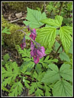 First Bleeding Hearts |
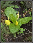 Skunk Cabbage |
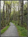 Interurban Trail |
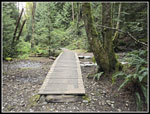 Two Bridges |
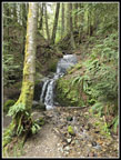 First Waterfall |
 Trillium Time |
 Lost Lake Trail |
 Yellow Violet |
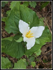 Great Trillium |
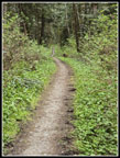 Narrow Old Road |
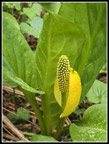 Another Skunk Cabbage |
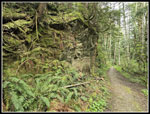 Sandstone Wall |
 Steep Wall |
 More Wall |
 More Bleeding Hears |
 Narrow Waterfall |
 Lost Lake |
 Lost Lake II |
 Waterfall From Side |
 Lost Lake Falls |
 Closer Look |
 Cliff Ramp |
 Rock Trail Bleeding Hearts |
 Many Bleeding Hearts |
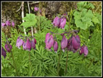 Closer Look At Hearts |
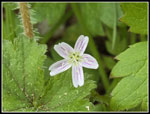 Spring Beauty |
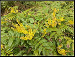 Oregon Grape Flowers |
 Lower Rock Trail |
 Moss & Ferns |
 Spring Beauty II |
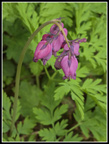 Nice Bleeding Hearts |
 Moss & Ferns II |
 Overhanging Rock |
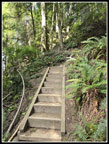 Stairway |
 Cyrus Gates Overlook |
 Bottom Of Mt. Baker |
 The Trail |
 Another Yellow Violet |
 Calypso Orchid |
 Yes, More Trail |
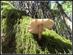 Mushroom Bottom |
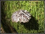 Mushroom Top |
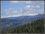 More Of Mt. Baker |
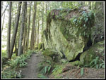 Big Rock |
 Back To Road/Trail |
 Wide Turns |
 Tri Trillium |
 Nearing The End |
Trips - 2025
Home