04-13-25
I
stayed home on Saturday and I was looking for a longer than average
hike on Sunday. It looked to be cold in the morning then sunny and
warming. I wanted to get in a good wildflower hike. It is a little
early for my favorite wildflower hikes east of the Cascades. I have
seen a few recently on the west side. It looked to be the perfect time
for a lower elevation hike for wildflowers. Cougar Mountain fit the
bill perfectly. I did a fun 13 mile loop in mild April two years ago. I
set out to do a similar hike this time. I was on my way at about 7:20
am. I reached the Red Town Trailhead and was on the trail at 7:56 am. I
was alone in the north lot and the main lot was about half full. It was
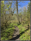
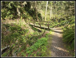
a chilly 37F when I started out. I began on the Wildside Trail. I would
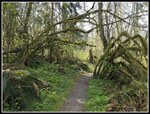
hike many different trails on this long loop. Coal Creek had a good
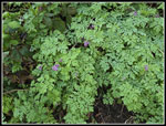
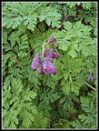
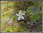
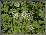
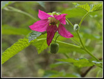
flow seen as I crossed the bridge. I saw the first blooming bleeding
hearts near the start. I kept seeing them in many places on my route.
So far this spring I had seen the leaves but not a single flower. I
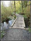
crossed the road by the Ford Slope and the boardwalk was nearly at
water level. That is about as high as I have seen water there. The
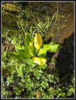
trail quickly begins to climb. I saw some salmonberry flowers and then
the trillium show began.
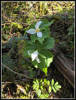
I expect to see more trillium here than anywhere else on Cougar. This time there were multiple patches but less than usual. They were right near peak. I continued to see trillium in many places but it was not as good as some years. I usually continue to the Indian Trail and head for the Quarry Trail or the trail to Far Country Lookout. This day I was heading for DeLeo Wall so I took a trail that heads up Marshall Hill then drops to DeLeo Wall. Along the way I saw more bleeding hearts and trillium I also saw blooming yellow violets. As expected they were blooming all over Cougar Mountain. The trail reached the top of Marshall Hill and I looked for a short cut trail that drops to DeLeo Wall. The GPS said I just passed it. I went back and found a tiny space in the salal. There is a route. It is not clear that it is a much used trail. Last time I took a longer route down to the DeLeo Wall Trail and then back to the wall. I took it again. I reached DeLeo Wall at 9:01 am. I was hiking at a good pace but all the photo stops had my overall pace below average.
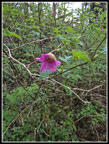
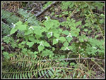
I immediately looked for chocolate lilies. They ares so well camouflaged I usually take a few minutes to find the first one. Once I see the leaves those are easier to find than the flowers. I found the leaves and a flower. Then I started seeing all the leaves with no flowers. The stalks were cut off just below where the flowers were. Someone or something cut off half a dozen of the flowers. I was disappointed. I found three flowers but six were gone. I looked around nearby and did not find any others. I have seen Indian paintbrush blooming here but not this time. I went back to the main viewpoint and took another look. I saw one than another and another. One was a double and one was a triple flower. It turns out that there were a dozen in bloom. I ended up with some good photos. By the time I had a food and water break it was 9:21 am. It was time to head on. I retraced my steps and continued on towards the Indian Trail. I continued to see trillium along the trail along with some small spring beauty. Those were just beginning to open. Later on I would see some in full bloom. The trail has lots of mossy trees and logs. I had plenty of neat views along here. I reached the Indian Trail and turned right. In a short distance I took a side route over to the top of Far Country Falls.
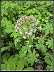
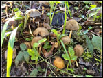
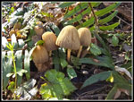
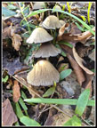
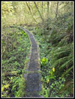
The falls is not a wild falls like Coal Creek Falls. It is multiple small falls dropping with sword ferns all around. It was much bigger than usual. I soon headed back to the trail. I quickly turned off on another side trail to the bottom of the falls. The views were good allowing for the fact there is seldom a whole lot of water. After that I followed the Indian Trail a short distance and turned off on the trail to Far Country Lookout. I saw some more bleeding hearts and one mostly open spring beauty. The view from the lookout are fast disappearing as the trees grow. The Shy Bear Trail drops from the lookout and then begins to slowly climb again. I found one really nice mushroom display but few flowers. The mushrooms were many dozens of them. I often take a right at the next junction on the trail to Deceiver Ridge and Long View Peak. This time I stayed straight on the Shy Bear Trail. This trail goes by one of the better skunk cabbage displays on Cougar. It was getting a bit late for skunk cabbage but I expected many to still by a brilliant yellow color. A boardwalk crosses a swamp, Thats were most of the skunk cabbage are located. Some were past prime but many were still blooming.
The trail climbs then drops to another skunk cabbage swamp. This one was shielded by new leaves. I saw only a few skunk cabbages. Now the trail ascended to the junction with Fred's Railroad. I stopped there to take off one layer as it was getting much warmer. I left my loop to head up Wilderness Peak. At Shy Bear Pass I turned left on the newish summit trail. The old trail has been obliterated. The new one is 1.5 times the distance of the old an much less steep. I had seen some people off and on though not many so far. At the summit one guy was leaving and one stayed. We ended up talked for 10 minutes. At 11:11 am I started down. I passed several more groups near the top. Hikers coming form Highway 900 often go to the summit. I dropped back to the pas and continued to the junction with Fred's Railroad. I took that trail passed the top of the Quarry Trail and on to the East Fork Trail. I turned right there heading for the Clay Pit.
There once was a trail to Wilderness Peak off this trail. It was only in place for a few years before it was abandoned and officially closed. I occasionally find the start but had not hiked it in about 25 years. The start was a bit more open this time. I decided to follow it a ways. I found cut logs, some recently cut. It gets less obvious farther along. I followed it until I reached another trail. I had to check my map to figure which trail this was. It turned out to be the old Wilderness Peak Trail not far from the summit. That was enough. I turned around and headed back. I have hiked the older trail from the Clay Pit to Wilderness Peak a couple times in the past 25 years but not this slightly newer trail. It was big surprise to see it is still usable.
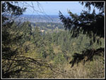
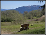
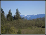
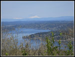
I reached Jerry's Duck Pond and soon arrived at the Clay Pit Road just down from the Clay Pit. it only took a couple minutes to reach it. The sky was mostly blue as I had a very clear look at Tiger 2 and 1 plus peaks of the Cascade front. I stopped at the bench for another food and water break. It was a bit muddy but less so than a month or so ago. Next, I headed for Anti-Aircraft Peak. The trail drops to cross Tibbetts Creek and climbs to AA Peak. Along the way I detoured on the route to Cougar Pass. There is a creek a tenth of a mile in that has a good skunk cabbage display. I was very surprised to see none in bloom. I was too late. I went back to the main trail and continued to AA Peak . Near the creek I found the best single display of blooming trillium. I found patches of 8 to 12 trillium together. Near AA Peak Trailhead I found two WTA trail workers at work digging drains. I stopped at the Million Dollar View and found a good view of Mt. Baker. I went on to the picnic shelter at the far end of the meadow.
I arrived at the shelter at 1:08 pm. I had traveled about 10.5 miles so far. I had 3.5 miles to go. It was now quite warm in the sunshine. My last break lasted 16 minutes. It was so nice and warm I did not want to leave. I still had 3.5 miles to go so it was time. I headed to the top of AA Peak where the Lost Beagle Trail goes right and left. I usually take the right trail and drop to the Klondike Swamp Trail. This day I felt like going left and down to the Anti-Aircraft Ridge Trail. This route is just a little longer that the other. At the junction I met another group of trail workers at work. The AA Ridge Trail took me to Cougar Pass and down to the Klondike Swamp Trail. The wildflower I saw the most of was spring beauty. Now in mid afternoon they were opening. I found many that were fully open. My route took be back to the Sky Country Trailhead where I was just 1 mile from Red Town. The last mile downhill went by pretty quickly. I reached my car in the now nearly full parking lot at 2:33 pm. For the day I hiked 14 miles with 2200' of elevation gain. With breaks and a lot of photo stops I was on the trail for 6:33.
This turned out to be a good choice for a trip. The wildflower show was very good. I saw them for most of the hike. It was cold enough for gloves at the start but it was 59F and sunny at the end. It felt much warmer. On my previous hike I did 17 miles so that gives my 31 miles in one week. With my average at 9.5 miles per hike that works out to be 6 miles per hike longer on average. I felt good at the end though I was as bit stiff the next morning. It was almost a repeat of my mid April 2023 hike except for the unplanned second trip up Wilderness Peak that added almost an extra mile. It was nice to have a hike with more than just a couple wildflowers as I had seen the past few weeks.
Click on thumbnails to get
larger pictures.
Trips - 2025
Home
I expect to see more trillium here than anywhere else on Cougar. This time there were multiple patches but less than usual. They were right near peak. I continued to see trillium in many places but it was not as good as some years. I usually continue to the Indian Trail and head for the Quarry Trail or the trail to Far Country Lookout. This day I was heading for DeLeo Wall so I took a trail that heads up Marshall Hill then drops to DeLeo Wall. Along the way I saw more bleeding hearts and trillium I also saw blooming yellow violets. As expected they were blooming all over Cougar Mountain. The trail reached the top of Marshall Hill and I looked for a short cut trail that drops to DeLeo Wall. The GPS said I just passed it. I went back and found a tiny space in the salal. There is a route. It is not clear that it is a much used trail. Last time I took a longer route down to the DeLeo Wall Trail and then back to the wall. I took it again. I reached DeLeo Wall at 9:01 am. I was hiking at a good pace but all the photo stops had my overall pace below average.
I immediately looked for chocolate lilies. They ares so well camouflaged I usually take a few minutes to find the first one. Once I see the leaves those are easier to find than the flowers. I found the leaves and a flower. Then I started seeing all the leaves with no flowers. The stalks were cut off just below where the flowers were. Someone or something cut off half a dozen of the flowers. I was disappointed. I found three flowers but six were gone. I looked around nearby and did not find any others. I have seen Indian paintbrush blooming here but not this time. I went back to the main viewpoint and took another look. I saw one than another and another. One was a double and one was a triple flower. It turns out that there were a dozen in bloom. I ended up with some good photos. By the time I had a food and water break it was 9:21 am. It was time to head on. I retraced my steps and continued on towards the Indian Trail. I continued to see trillium along the trail along with some small spring beauty. Those were just beginning to open. Later on I would see some in full bloom. The trail has lots of mossy trees and logs. I had plenty of neat views along here. I reached the Indian Trail and turned right. In a short distance I took a side route over to the top of Far Country Falls.
The falls is not a wild falls like Coal Creek Falls. It is multiple small falls dropping with sword ferns all around. It was much bigger than usual. I soon headed back to the trail. I quickly turned off on another side trail to the bottom of the falls. The views were good allowing for the fact there is seldom a whole lot of water. After that I followed the Indian Trail a short distance and turned off on the trail to Far Country Lookout. I saw some more bleeding hearts and one mostly open spring beauty. The view from the lookout are fast disappearing as the trees grow. The Shy Bear Trail drops from the lookout and then begins to slowly climb again. I found one really nice mushroom display but few flowers. The mushrooms were many dozens of them. I often take a right at the next junction on the trail to Deceiver Ridge and Long View Peak. This time I stayed straight on the Shy Bear Trail. This trail goes by one of the better skunk cabbage displays on Cougar. It was getting a bit late for skunk cabbage but I expected many to still by a brilliant yellow color. A boardwalk crosses a swamp, Thats were most of the skunk cabbage are located. Some were past prime but many were still blooming.
The trail climbs then drops to another skunk cabbage swamp. This one was shielded by new leaves. I saw only a few skunk cabbages. Now the trail ascended to the junction with Fred's Railroad. I stopped there to take off one layer as it was getting much warmer. I left my loop to head up Wilderness Peak. At Shy Bear Pass I turned left on the newish summit trail. The old trail has been obliterated. The new one is 1.5 times the distance of the old an much less steep. I had seen some people off and on though not many so far. At the summit one guy was leaving and one stayed. We ended up talked for 10 minutes. At 11:11 am I started down. I passed several more groups near the top. Hikers coming form Highway 900 often go to the summit. I dropped back to the pas and continued to the junction with Fred's Railroad. I took that trail passed the top of the Quarry Trail and on to the East Fork Trail. I turned right there heading for the Clay Pit.
There once was a trail to Wilderness Peak off this trail. It was only in place for a few years before it was abandoned and officially closed. I occasionally find the start but had not hiked it in about 25 years. The start was a bit more open this time. I decided to follow it a ways. I found cut logs, some recently cut. It gets less obvious farther along. I followed it until I reached another trail. I had to check my map to figure which trail this was. It turned out to be the old Wilderness Peak Trail not far from the summit. That was enough. I turned around and headed back. I have hiked the older trail from the Clay Pit to Wilderness Peak a couple times in the past 25 years but not this slightly newer trail. It was big surprise to see it is still usable.
I reached Jerry's Duck Pond and soon arrived at the Clay Pit Road just down from the Clay Pit. it only took a couple minutes to reach it. The sky was mostly blue as I had a very clear look at Tiger 2 and 1 plus peaks of the Cascade front. I stopped at the bench for another food and water break. It was a bit muddy but less so than a month or so ago. Next, I headed for Anti-Aircraft Peak. The trail drops to cross Tibbetts Creek and climbs to AA Peak. Along the way I detoured on the route to Cougar Pass. There is a creek a tenth of a mile in that has a good skunk cabbage display. I was very surprised to see none in bloom. I was too late. I went back to the main trail and continued to AA Peak . Near the creek I found the best single display of blooming trillium. I found patches of 8 to 12 trillium together. Near AA Peak Trailhead I found two WTA trail workers at work digging drains. I stopped at the Million Dollar View and found a good view of Mt. Baker. I went on to the picnic shelter at the far end of the meadow.
I arrived at the shelter at 1:08 pm. I had traveled about 10.5 miles so far. I had 3.5 miles to go. It was now quite warm in the sunshine. My last break lasted 16 minutes. It was so nice and warm I did not want to leave. I still had 3.5 miles to go so it was time. I headed to the top of AA Peak where the Lost Beagle Trail goes right and left. I usually take the right trail and drop to the Klondike Swamp Trail. This day I felt like going left and down to the Anti-Aircraft Ridge Trail. This route is just a little longer that the other. At the junction I met another group of trail workers at work. The AA Ridge Trail took me to Cougar Pass and down to the Klondike Swamp Trail. The wildflower I saw the most of was spring beauty. Now in mid afternoon they were opening. I found many that were fully open. My route took be back to the Sky Country Trailhead where I was just 1 mile from Red Town. The last mile downhill went by pretty quickly. I reached my car in the now nearly full parking lot at 2:33 pm. For the day I hiked 14 miles with 2200' of elevation gain. With breaks and a lot of photo stops I was on the trail for 6:33.
This turned out to be a good choice for a trip. The wildflower show was very good. I saw them for most of the hike. It was cold enough for gloves at the start but it was 59F and sunny at the end. It felt much warmer. On my previous hike I did 17 miles so that gives my 31 miles in one week. With my average at 9.5 miles per hike that works out to be 6 miles per hike longer on average. I felt good at the end though I was as bit stiff the next morning. It was almost a repeat of my mid April 2023 hike except for the unplanned second trip up Wilderness Peak that added almost an extra mile. It was nice to have a hike with more than just a couple wildflowers as I had seen the past few weeks.
 First Bleeding Hearts |
 Closer Look |
 Salmonberry Flower |
 Coltsfoot |
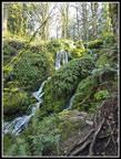
 Lots Of Water |
 Blooming Trillium |
 Bleeding Hearts |
 Another Trillium |
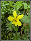 Yellow Violet |
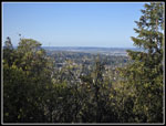 DeLeo Wall View |
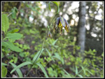 Chocolate Lily |
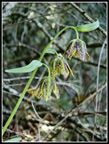 Triple Chocolate Lilies |
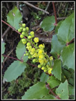 Oregon Grape |
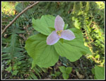 Pink Trillium |
 Sunshine & Shadows |
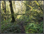 Mossy Spot |
 Top Of Falls |
 Far Country Falls |
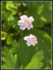 First Spring Beauty |
 Far Country Lookout |
 First Mushrooms |
 Small Shrooms |
 Closer Shroom Look |
 Boardwalk |
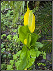 Skunk Cabbage |
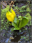 Skunk Cabbage II |
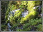
 Lit Up Moss |
 Twin Trillium |
 Single Spring Beauty |
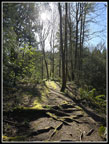
 Abandoned Trail |
 Devil's Club! |
 More Skunk Cabbage |
 Many Coltsfoot |
 Clay Pit View |
 Another View |
 Multiple Trillium |
 Tibbetts Creek Bridge |
 More Sunshine |
 Mt. Baker |
 Mossy Arbor |
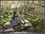
 Last Bridge |
 Salmonberry Close Up |
Trips - 2025
Home