I had planned to scramble up Big Jim Mountain for many years. It's too far for a day trip so I needed to find the time for a backpack trip. I also needed a partner who could arrange to join me. On July 27th 2001 the time arrived. Gary was able to take time off from family and work. The weather was forecast to deteriorate late in the weekend so we planned to head out on Friday. The trailhead is off of Highway 2 near where the Wenatchee River meets the road. The trailhead is at 2800'. This trail is open to horses and some stretches are "dusty". All in all the trail was in good shape. I have hiked Icicle Ridge but never in this area.
This is not an easy trip. It is 9 miles and just over 4000' to Lake Augusta at 6854'. There are several ups and downs which add substantially more elevation gain up to the
 lake. From Augusta it is another 900' to the top of Big Jim at
7763'. That's if you take the best way up. If you take our way it was several
hundred feet more. The good part of hiking well east of the crest is the
warm weather. The bad part is the very warm weather. It had been a year
since I had hefted a 45 pound backpack. The weight and the warmth were
a good challenge for me. The early trail switchbacks higher and higher
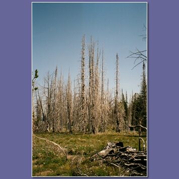
up the ridge. As it levels out the trail changes dramatically. We entered
a major burn from years back. The silvered forest is huge. Suddenly there
are tremendous views in all directions. We didn't know what the trail would
be like but this section was far more beautiful than I was expecting.
The ground was covered with wildflowers. It was a
meadow to rival far more well know places. At this point we had to stop
for a snack and to
lake. From Augusta it is another 900' to the top of Big Jim at
7763'. That's if you take the best way up. If you take our way it was several
hundred feet more. The good part of hiking well east of the crest is the
warm weather. The bad part is the very warm weather. It had been a year
since I had hefted a 45 pound backpack. The weight and the warmth were
a good challenge for me. The early trail switchbacks higher and higher
up the ridge. As it levels out the trail changes dramatically. We entered
a major burn from years back. The silvered forest is huge. Suddenly there
are tremendous views in all directions. We didn't know what the trail would
be like but this section was far more beautiful than I was expecting.
The ground was covered with wildflowers. It was a
meadow to rival far more well know places. At this point we had to stop
for a snack and to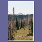 break out the cameras. After a snack
it was time to move on. We continued through the burn and back into forest.
Soon the snack wore off and it was time for lunch. It was getting fairly
warm by this time. The break was just what I needed. After lunch we began
to climb again. The trail ascends up to a ridge crest at 6 1/2 miles and
6700'. We were only 150' below the lake level. Unfortunately, the trail descends
down into a valley. 350' later we arrived at the bottom of the valley. Now
the trail winds through meadows and begins to climb to the lake at the end
of the valley. Gaining this last 500' in the afternoon sun was rough. Just
before the lake we saw the first people of the day. Two men riding horses
passed us on their way out. At the lake I could finally get the weight off
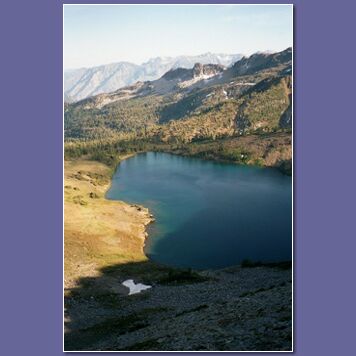
and relax. The lake is much prettier than I was expecting. It is rimmed on
three sides by steep walls and their are Larch trees around it. Now that
we had reached the lake it was time to decide just how to get up Big Jim
Mountain.
break out the cameras. After a snack
it was time to move on. We continued through the burn and back into forest.
Soon the snack wore off and it was time for lunch. It was getting fairly
warm by this time. The break was just what I needed. After lunch we began
to climb again. The trail ascends up to a ridge crest at 6 1/2 miles and
6700'. We were only 150' below the lake level. Unfortunately, the trail descends
down into a valley. 350' later we arrived at the bottom of the valley. Now
the trail winds through meadows and begins to climb to the lake at the end
of the valley. Gaining this last 500' in the afternoon sun was rough. Just
before the lake we saw the first people of the day. Two men riding horses
passed us on their way out. At the lake I could finally get the weight off
and relax. The lake is much prettier than I was expecting. It is rimmed on
three sides by steep walls and their are Larch trees around it. Now that
we had reached the lake it was time to decide just how to get up Big Jim
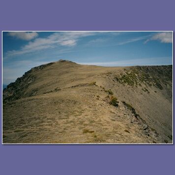
Mountain. The mountain is not visible from the lake. It is at the far end of the lake but the steep ridge blocks a view of the summit. We first thought of climbing straight up from the back side of the lake. This route seemed too steep so we decided to follow the trail to the ridge crest to the left of the lake. We pulled out day packs, put in food, water, and clothing and headed out. The trail to the top of the south ridge was a steep but easy walk. At the crest we turned right and followed the ridge up to one high point and beyond. Shortly thereafter the ridge became much more difficult. We dropped down on the lake side and reassessed the situation. I thought I could traverse and reacquire the ridge. Gary was more pessimistic and felt a further descent was best before heading back up. We decided to split and each try our own way. I made it 3/4 of the way across and found the going to be too much for me. By now Gary had dropped well below me and was traversing below all the rocks. Instead of retracing my steps I decided to proceed straight down. It was a more difficult scramble than it appeared. I was nearly stopped at one point but found a way through and reached the bottom. Now I had to traverse
 across and regain several hundred feet to get back to the ridge. I finally
caught up with Gary who was patiently waiting on the ridge top. Now the
way became an easy walk as the summit of Big Jim was visible up ahead. The
wind had been picking up since we reached the lake and was now very strong.
across and regain several hundred feet to get back to the ridge. I finally
caught up with Gary who was patiently waiting on the ridge top. Now the
way became an easy walk as the summit of Big Jim was visible up ahead. The
wind had been picking up since we reached the lake and was now very strong.
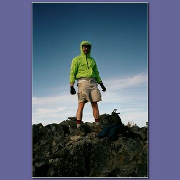
The last part was quickly done with spectacular views all the way. At the summit I way extremely happy. This trip was a decade in the planning. It was also quite a trip. We traveled 9 miles gaining 4400' with full backpacks. We then traveled another mile gaining 1100' more. I was worn out by the time we reached the summit. The wind continued to pick up. I must have been blowing 25 mph with even stronger gusts. The views were spectacular in all directions. The clouds were definitely coming in. After a short stay it was time to head down to the lake and set up camp.
We had two choices for the descent. One was to retrace our steps back along the ridge. The other was to climb straight down the ridge to the lake. What appeared to be near vertical when viewed from the lake was much less scary when looking straight down. It was quite steep but not close to vertical. We headed straight down. The descent was very fast. In hind sight, this is by far the best way to go up Big Jim. From the lake shore we still had to travel all the way around to the the point where our packs were. The lake shore is meadowy with some trees. In a short time we were back at our packs. The wind was blowing at the lake but much less powerfully than on the ridge. We set up camp and prepared for dinner. We each brought along a small, light Sierra Designs Flashlight tent. They are light and large
 enough for one large person. More on the tents later. As the wind picked
up we searched for a dinner spot that was sheltered. This proved to be fairly
hard to find. The best we could do was to drop down the valley a short distance
and hunker down behind some small vegetation. That was one cold, windy dinner.
After the days exertions it was very welcome. After dinner we made sure
to hang all our food from a tree and prepared for bed. By now the wind was
growing stronger. As I drifted off to sleep it began to rain. The howling
of the wind and the rain caused me to wake up several times during the night.
The Flashlight tent bent and swayed in the wind. I had serious worries as
to whether it would survive the night. I can now say that the tent was pretty
strong considering its lightness. Still, if there is much wind forecast I
think I'll leave it at home next time.
enough for one large person. More on the tents later. As the wind picked
up we searched for a dinner spot that was sheltered. This proved to be fairly
hard to find. The best we could do was to drop down the valley a short distance
and hunker down behind some small vegetation. That was one cold, windy dinner.
After the days exertions it was very welcome. After dinner we made sure
to hang all our food from a tree and prepared for bed. By now the wind was
growing stronger. As I drifted off to sleep it began to rain. The howling
of the wind and the rain caused me to wake up several times during the night.
The Flashlight tent bent and swayed in the wind. I had serious worries as
to whether it would survive the night. I can now say that the tent was pretty
strong considering its lightness. Still, if there is much wind forecast I
think I'll leave it at home next time. In the morning we were relieved to see that both tents were still standing. The rain continued so we stayed put. When it stopped we jumped out for breakfast. The original plan was to stay another day and head home on Sunday. There were several other scrambles we wanted to do. The weather was still lousy but at least the rain had stopped. We could stay put and hope for better weather or take this break in the rain and take off. Common sense got the better of us and we decided to head on home. The next task was to break camp and get everything back into our packs. This was far harder than I expected. I had never taken down a tent in 30 mph winds. I could not put one part down without it flying away at high speed. I don't know how long it took but I do know that I was cursing up a storm the whole time. Gary seemed to be able to keep his temper controlled much better than me. It took much longer than normal to get everything ready. Finally we headed down the valley. Unlike most hikes, this one gives you a 350' gain before you are even warmed up. We trudged up the ridge and back to the crest. After dropping down and traversing the burn we dropped out
 of the wind for the long final descent. The gods were smiling as we encountered
only a little rain on the way back. I was surprised to see two day hikers
in the burn area heading up towards the lake. I guess I'm not tough enough
to try an 18 mile 4800' day hike on an overcast and windy day. Back at the
trailhead the weather had improved and was looking fairly good. All in all,
I still think heading down was the right decision. Despite the weather,
this turned out to be a very memorable trip. The flowers were spectacular.
The views were great. Best of all I finally reached the summit of Big Jim
Mountain.
of the wind for the long final descent. The gods were smiling as we encountered
only a little rain on the way back. I was surprised to see two day hikers
in the burn area heading up towards the lake. I guess I'm not tough enough
to try an 18 mile 4800' day hike on an overcast and windy day. Back at the
trailhead the weather had improved and was looking fairly good. All in all,
I still think heading down was the right decision. Despite the weather,
this turned out to be a very memorable trip. The flowers were spectacular.
The views were great. Best of all I finally reached the summit of Big Jim
Mountain.