This is one of my favorite loop
trips. The two trailheads are only about 100' apart. The total distance is
12 miles with 3900' of elevation gain. You will not find this trip in any
guidebooks as it has an off trail ridge walk connecting two trails. It has
deep forest, several mountain tops with spectacular views, and in season it
has Larch. In early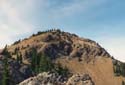 October of most years the Larch trees turn a brilliant gold before dropping
their needles. Motorcycles are allowed on the trail portion of this route.
Even so, it is still worth the effort. Early and late season snow will stop
the cycles and leave you blessed peace and quiet. The trailhead is at the
end of the Stafford Creek Road off of the North Fork Teanaway Road. Proceed
one mile beyond 29 Pines Campgrounds and turn right after crossing Stafford
Creek. I prefer to do the trip clockwise although I enjoy it in either direction.
October of most years the Larch trees turn a brilliant gold before dropping
their needles. Motorcycles are allowed on the trail portion of this route.
Even so, it is still worth the effort. Early and late season snow will stop
the cycles and leave you blessed peace and quiet. The trailhead is at the
end of the Stafford Creek Road off of the North Fork Teanaway Road. Proceed
one mile beyond 29 Pines Campgrounds and turn right after crossing Stafford
Creek. I prefer to do the trip clockwise although I enjoy it in either direction.
Going clockwise you head out on the Miller Peak trail. The trail is fairly flat for the first mile with several creek crossings. When it starts to climb it really gets down to business. Some stretches are quite steep but the trail is generally well maintained. Near the ridge top the views begin. Many of the Teanaway peaks are visible. As you crest the ridge the rest of the loop can be seen. Far across the valley is Iron Bear Peak where you will be later in the day. The last section to the top of Miller is very steep but not at all dangerous. At the summit you have terrific views. Stuart is to the Northwest. Three Brothers is close to the North. Enjoy the view and get ready for the fun part of this trip.
Make sure you have a map for the next section. You must start down the correct ridge. It is very obvious on a map but more difficult to find on a foggy day. The section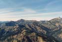 from the summit is steep and has some loose scree. It is easier on snow but
not too bad when bare. If you are not comfortable on this terrain go back.
Miller is a fine destination in it's own right. After a steep descent the
ridge flattens out. There is no trail but none is needed - or wanted. Follow
the ridge through meadows and up over several rocky stretches. The motorcycle
trail crosses around Miller Peak and is down below the ridge. The ridge slowly
descends and the trail below gains elevation. After an enjoyable ramble on
the ridge the trail comes into view only about 100' below. It will be apparent
when to descend to the trail. The trail switches back several times and drops
down to a thin ridge where the trail was blasted out. The low point on the
ridge is where a logging road is met. This road comes up from Shaser Creek.
from the summit is steep and has some loose scree. It is easier on snow but
not too bad when bare. If you are not comfortable on this terrain go back.
Miller is a fine destination in it's own right. After a steep descent the
ridge flattens out. There is no trail but none is needed - or wanted. Follow
the ridge through meadows and up over several rocky stretches. The motorcycle
trail crosses around Miller Peak and is down below the ridge. The ridge slowly
descends and the trail below gains elevation. After an enjoyable ramble on
the ridge the trail comes into view only about 100' below. It will be apparent
when to descend to the trail. The trail switches back several times and drops
down to a thin ridge where the trail was blasted out. The low point on the
ridge is where a logging road is met. This road comes up from Shaser Creek.
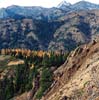
After the road intersection the trail has a very steep section with no switchbacks. Be prepared to grind out the elevation gain here. At the top the trail goes back to a nice grade. This northern facing section is where the snow lasts the longest in the spring. When the trail is buried it is useful to use a map to navigate up to the top of Iron Bear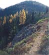 Peak. From the road intersection to the top of Iron Bear Peak there are
many Larch trees. This is a golden walk during the peak of the Larch season.
At the top of Iron Bear, Miller Peak and most of the route around are quite
apparent. In season there are huge forests of Larch visible. From this point
it is all downhill back to the trailhead. The first section is a series of
switchbacks dropping down to Iron Bear Pass. At the pass four trails intersect.
The Iron Bear trail continues as the Teanaway Ridge trail eventually reaching
Red Top Lookout. A left hand turn drops down Iron Creek to a trailhead off
of Highway 97. A right turn takes you on the Bear Creek Trail which continues
back to the trailhead. The trail seems to go on and on as it drops back down
into the valley of Bear Creek. The last few miles are flat as you finish
up. Back at the trailhead you cross the creek one last time. This is a great
place to soak your feet on a hot day and relax before the drive home.
Peak. From the road intersection to the top of Iron Bear Peak there are
many Larch trees. This is a golden walk during the peak of the Larch season.
At the top of Iron Bear, Miller Peak and most of the route around are quite
apparent. In season there are huge forests of Larch visible. From this point
it is all downhill back to the trailhead. The first section is a series of
switchbacks dropping down to Iron Bear Pass. At the pass four trails intersect.
The Iron Bear trail continues as the Teanaway Ridge trail eventually reaching
Red Top Lookout. A left hand turn drops down Iron Creek to a trailhead off
of Highway 97. A right turn takes you on the Bear Creek Trail which continues
back to the trailhead. The trail seems to go on and on as it drops back down
into the valley of Bear Creek. The last few miles are flat as you finish
up. Back at the trailhead you cross the creek one last time. This is a great
place to soak your feet on a hot day and relax before the drive home.
 I am constantly looking for loop trips where most of the route is not
retraced. It is very rare that only one car is needed and none of the route
is retraced. This alone puts this route on my list of favorites. The off
trail ridge running is another huge bonus. The two summit views are spectacular.
The low forest areas hold snow long after the upper slopes are bare. By trudging
through some snow early you can find solitude in the Spring. In the Fall
the Larch are enough to rate this trip highly. Put all these factors together
and you have a real winner.
I am constantly looking for loop trips where most of the route is not
retraced. It is very rare that only one car is needed and none of the route
is retraced. This alone puts this route on my list of favorites. The off
trail ridge running is another huge bonus. The two summit views are spectacular.
The low forest areas hold snow long after the upper slopes are bare. By trudging
through some snow early you can find solitude in the Spring. In the Fall
the Larch are enough to rate this trip highly. Put all these factors together
and you have a real winner.
October of most years the Larch trees turn a brilliant gold before dropping
their needles. Motorcycles are allowed on the trail portion of this route.
Even so, it is still worth the effort. Early and late season snow will stop
the cycles and leave you blessed peace and quiet. The trailhead is at the
end of the Stafford Creek Road off of the North Fork Teanaway Road. Proceed
one mile beyond 29 Pines Campgrounds and turn right after crossing Stafford
Creek. I prefer to do the trip clockwise although I enjoy it in either direction.
Going clockwise you head out on the Miller Peak trail. The trail is fairly flat for the first mile with several creek crossings. When it starts to climb it really gets down to business. Some stretches are quite steep but the trail is generally well maintained. Near the ridge top the views begin. Many of the Teanaway peaks are visible. As you crest the ridge the rest of the loop can be seen. Far across the valley is Iron Bear Peak where you will be later in the day. The last section to the top of Miller is very steep but not at all dangerous. At the summit you have terrific views. Stuart is to the Northwest. Three Brothers is close to the North. Enjoy the view and get ready for the fun part of this trip.
Make sure you have a map for the next section. You must start down the correct ridge. It is very obvious on a map but more difficult to find on a foggy day. The section
from the summit is steep and has some loose scree. It is easier on snow but
not too bad when bare. If you are not comfortable on this terrain go back.
Miller is a fine destination in it's own right. After a steep descent the
ridge flattens out. There is no trail but none is needed - or wanted. Follow
the ridge through meadows and up over several rocky stretches. The motorcycle
trail crosses around Miller Peak and is down below the ridge. The ridge slowly
descends and the trail below gains elevation. After an enjoyable ramble on
the ridge the trail comes into view only about 100' below. It will be apparent
when to descend to the trail. The trail switches back several times and drops
down to a thin ridge where the trail was blasted out. The low point on the
ridge is where a logging road is met. This road comes up from Shaser Creek.
After the road intersection the trail has a very steep section with no switchbacks. Be prepared to grind out the elevation gain here. At the top the trail goes back to a nice grade. This northern facing section is where the snow lasts the longest in the spring. When the trail is buried it is useful to use a map to navigate up to the top of Iron Bear
Peak. From the road intersection to the top of Iron Bear Peak there are
many Larch trees. This is a golden walk during the peak of the Larch season.
At the top of Iron Bear, Miller Peak and most of the route around are quite
apparent. In season there are huge forests of Larch visible. From this point
it is all downhill back to the trailhead. The first section is a series of
switchbacks dropping down to Iron Bear Pass. At the pass four trails intersect.
The Iron Bear trail continues as the Teanaway Ridge trail eventually reaching
Red Top Lookout. A left hand turn drops down Iron Creek to a trailhead off
of Highway 97. A right turn takes you on the Bear Creek Trail which continues
back to the trailhead. The trail seems to go on and on as it drops back down
into the valley of Bear Creek. The last few miles are flat as you finish
up. Back at the trailhead you cross the creek one last time. This is a great
place to soak your feet on a hot day and relax before the drive home.
I am constantly looking for loop trips where most of the route is not
retraced. It is very rare that only one car is needed and none of the route
is retraced. This alone puts this route on my list of favorites. The off
trail ridge running is another huge bonus. The two summit views are spectacular.
The low forest areas hold snow long after the upper slopes are bare. By trudging
through some snow early you can find solitude in the Spring. In the Fall
the Larch are enough to rate this trip highly. Put all these factors together
and you have a real winner.