8-13-14-94
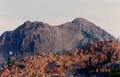
The Cradle is a seldom scrambled
peak located directly east of Mount Daniel. At 7467' it provides a commanding
view. Based on the summit register, only a few groups climb it each year.
I am glad to say I have been on top and I do not plan another trip any time
soon. My trip up the peak was with a Mountaineer party on a two day trip.
While I suppose this trip could be done in one grueling day, two days makes
more sense. Our trip was in mid August 1994 on a Saturday and a Sunday.
As with most overnight scrambles, our party was small. Only 4 others signed
up. Our leader was Chelsea Korte. He was a very good scrambler and leader.
We approached via Paddy-Go-Easy Pass, accessed from the Cle Elum River Road.
Since the first day would only take us to the pass we met late, somewhere
around 10:30 am. The downside of a late start on the eastern slopes is the
afternoon heat. This was a typical August day with the temperature already
in the mid 70's and rising when we started out. It has been nearly 8 years
since I took this trip so my memory may be a little hazy but I will recount
the route to the best of my recollection.
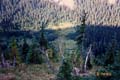
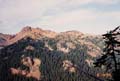
The trail to Paddy-Go-Easy Pass was short and fairly steep, gaining 2700' in 3 miles. The pass is at 6100'. That elevation gain in the bright sun was a good warm up for what was to come. By the time we reached the pass with our overnight packs we were all soaked with sweat. From the pass an easy trail headed southeast and dropped to Sprite Lake. At the far end of the lake we found a little shade and had our lunch. Since it was still early afternoon and we had only come 3 miles, most of the group wanted to do some exploring. Showing eminently good sense, Chelsea chose to lay back in the shade by the lake and relax. The rest of us headed cross country from the lake to the ridge top. Once on the ridge we scrambled farther southeast along the crest. This provided some excellent scrambling terrain. As I recall we summited on high point and then Point 6566. From there we headed straight down the eastern face on dirt and scree. It was like a semi-controled standing glissade. The scrambling was a lot of fun. When we returned to the lake Chelsea was still snoozing. It was now late afternoon and we started hunting for a camp site. There were no available sites near the lake that could house all of us so we headed back toward the pass. A little scouting and we found a great spot. It was very near the ridge crest with a large flat area and was higher than the trail and so partly secluded. From here both The Cradle and Mount Daniel seemed close enough to touch. The route to the Cradle requires dropping down the east side of the ridge to the valley bottom then climbing right up the side of The Cradle. While we were only 1300' below the summit we first would have to lose 1350', then gain 2650', and finally regain the last 1350' coming out to get back to the pass. That made for quite a bit of elevation gain and loss to get our net of 1300'. We had our dinner and studied The Cradle looking for the best route to take the next day. It was a nearly cloudless night and I was able to take some excellent photos of the surrounding peaks at sunset.
The next morning we awoke early and packed up our camp site. We all brought lighter day packs for day two. From Paddy-Go-Easy it was easy going down into the valley. In fairly short order we were at the bottom. Since this peak is so seldom climbed it is hard to quiz anyone who has done it. None of our party had been up before. We had Beckey's description and a rough idea from a friend of Chelsea's. But hey, what's the fun of doing a trip without a little route finding? From the valley bottom we headed right on a trail to the southeast for a little less than one mile. When the forest opened up somewhat we headed cross country up the slopes of The Cradle. At first we had thick underbrush to fight through. This soon gave way to a lightly forested grassy slope. We left the trail at about 5200' and hoped to crest the ridge at a 6600' pass south of the summit. The higher we climbed the worse the footing became. The upper stretch was lose dirt and scree. It was even worse than the last section of the route up Mt St Helens. Two steps up and 1 1/2 steps sliding right back down. There were still some small trees to hang onto but mostly it was slipping and sliding. We also tried to keep from being directly under another hiker as a number of rocks were knocked down the slope. I was glad our group was small or this could have been more of a problem. After a great deal of effort we were able to navigate to the pass we were seeking. From here we could look back across the valley and see Sprite Lake near the opposite ridge top. Our hope was to follow the ridge to the summit. This proved to be unfeasible. A serious rock climber with a rope and protection might be able to do it but not a group of scramblers. The only hope was to drop down on the east side and contour around to below the summit. From there it looked possible to scramble up to the summit. For those of you who have never traversed across scree slopes you don't know what you are missing. This one is a classic. Scree is made up of small rocks. They usually slide when stepped on. We aimed slightly uphill and still had trouble keeping on a level course. Every step up would slide you right back down again. We were now back out in the late morning sun and making very slow progress. As we came nearer the summit we reached a gully. It was steep but quite possible to scramble. There was some loose rock and again I was glad that our party was small. One member had used poles all the way and now needed both hands to climb. He had a tough time trying to tie them onto his pack. I was in the lead at this point and happy not to have anyone above me kicking any rocks loose. I climbed rocks on the left side of the gully and had an easier time than those who tried to go up the center. I topped out on the ridge within about 100' of the summit block. Chelsea took over form here to lead the final airy ridge section to the summit. Chelsea used several climbing moves to go up the left side of the block to the summit. From there he pointed out an easier route around to the right. This last part looked much worse than it actually was. By the time we reached the summit the temperature was well into the 80's and I was really feeling it.
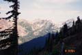
1994 was a bad drought year. There were a number of large wildfires through the Cascade Mountains. From the summit we could see smoke rising from the Icicle Creek area and a new fire that appeared to be in the area of Spectacle Lake. One fire fighting helicopter with a water bucket came by within 500' of the summit. It was a great deal of work on some awful terrain but a real neat summit. From 7467' the views were nearly limitless. Stuart, Rainier, Daniel and even North Cascades peaks were visible. As I said at the beginning, it was a tough route but I'm glad I made it to the top.
We talked over the best route to get down. Now that we were on top it was much easier to see all the options. The one thing we wanted to avoid was that half mile scree traverse. Well below the scree slope was a fairly flat area. It still had some snow in late August of a drought year. The ridge heading down to the east was fairly gentle. We decided to follow the east ridge part way down then drop straight to the level area. It required losing then gaining hundreds of extra feet but was far superior to that scree traverse. The route worked perfectly. The tough part was going from the bottom at about 6150' back up to the pass on the ridge at 6600'. Climbing that last 450' up sliding scree in the blazing sun was hard. From the pass we had a much easier time coming down the loose dirt and scree. In short order we were back at the valley floor and on the trail. At the intersection we turned left and had that last 1350' to gain. After all we had been through that day this last climb was murderous. Seldom do you have that much elevation to gain on the way out. Best of all, when we reached the ridge crest we had those heavy overnight packs to look forward to. By now it was in the upper 80's and I was covered in sweat from head to toe. The last 3 miles was tough on the knees but fairly short.
This turned out to be a good trip. We had a good group and a good leader. Since we weren't positive about the route there was a little more excitement than on most scrambles. The summit was great. Some of the off trail sections were fun. Still, this trip had more loose scree than any trip I have done or ever hope to do. If I did it again I would drop from the ridge top pass to the flat area and climb the eastern ridge. It means an extra 450' to gain and lose each way but is much easier. The weekend totals were 15 miles with 8500' of gain. I am glad to say I have climbed The Cradle and fairly sure I will not do it again. If any of you have done it I would be interested to hear about your experience.
The trail to Paddy-Go-Easy Pass was short and fairly steep, gaining 2700' in 3 miles. The pass is at 6100'. That elevation gain in the bright sun was a good warm up for what was to come. By the time we reached the pass with our overnight packs we were all soaked with sweat. From the pass an easy trail headed southeast and dropped to Sprite Lake. At the far end of the lake we found a little shade and had our lunch. Since it was still early afternoon and we had only come 3 miles, most of the group wanted to do some exploring. Showing eminently good sense, Chelsea chose to lay back in the shade by the lake and relax. The rest of us headed cross country from the lake to the ridge top. Once on the ridge we scrambled farther southeast along the crest. This provided some excellent scrambling terrain. As I recall we summited on high point and then Point 6566. From there we headed straight down the eastern face on dirt and scree. It was like a semi-controled standing glissade. The scrambling was a lot of fun. When we returned to the lake Chelsea was still snoozing. It was now late afternoon and we started hunting for a camp site. There were no available sites near the lake that could house all of us so we headed back toward the pass. A little scouting and we found a great spot. It was very near the ridge crest with a large flat area and was higher than the trail and so partly secluded. From here both The Cradle and Mount Daniel seemed close enough to touch. The route to the Cradle requires dropping down the east side of the ridge to the valley bottom then climbing right up the side of The Cradle. While we were only 1300' below the summit we first would have to lose 1350', then gain 2650', and finally regain the last 1350' coming out to get back to the pass. That made for quite a bit of elevation gain and loss to get our net of 1300'. We had our dinner and studied The Cradle looking for the best route to take the next day. It was a nearly cloudless night and I was able to take some excellent photos of the surrounding peaks at sunset.
The next morning we awoke early and packed up our camp site. We all brought lighter day packs for day two. From Paddy-Go-Easy it was easy going down into the valley. In fairly short order we were at the bottom. Since this peak is so seldom climbed it is hard to quiz anyone who has done it. None of our party had been up before. We had Beckey's description and a rough idea from a friend of Chelsea's. But hey, what's the fun of doing a trip without a little route finding? From the valley bottom we headed right on a trail to the southeast for a little less than one mile. When the forest opened up somewhat we headed cross country up the slopes of The Cradle. At first we had thick underbrush to fight through. This soon gave way to a lightly forested grassy slope. We left the trail at about 5200' and hoped to crest the ridge at a 6600' pass south of the summit. The higher we climbed the worse the footing became. The upper stretch was lose dirt and scree. It was even worse than the last section of the route up Mt St Helens. Two steps up and 1 1/2 steps sliding right back down. There were still some small trees to hang onto but mostly it was slipping and sliding. We also tried to keep from being directly under another hiker as a number of rocks were knocked down the slope. I was glad our group was small or this could have been more of a problem. After a great deal of effort we were able to navigate to the pass we were seeking. From here we could look back across the valley and see Sprite Lake near the opposite ridge top. Our hope was to follow the ridge to the summit. This proved to be unfeasible. A serious rock climber with a rope and protection might be able to do it but not a group of scramblers. The only hope was to drop down on the east side and contour around to below the summit. From there it looked possible to scramble up to the summit. For those of you who have never traversed across scree slopes you don't know what you are missing. This one is a classic. Scree is made up of small rocks. They usually slide when stepped on. We aimed slightly uphill and still had trouble keeping on a level course. Every step up would slide you right back down again. We were now back out in the late morning sun and making very slow progress. As we came nearer the summit we reached a gully. It was steep but quite possible to scramble. There was some loose rock and again I was glad that our party was small. One member had used poles all the way and now needed both hands to climb. He had a tough time trying to tie them onto his pack. I was in the lead at this point and happy not to have anyone above me kicking any rocks loose. I climbed rocks on the left side of the gully and had an easier time than those who tried to go up the center. I topped out on the ridge within about 100' of the summit block. Chelsea took over form here to lead the final airy ridge section to the summit. Chelsea used several climbing moves to go up the left side of the block to the summit. From there he pointed out an easier route around to the right. This last part looked much worse than it actually was. By the time we reached the summit the temperature was well into the 80's and I was really feeling it.
1994 was a bad drought year. There were a number of large wildfires through the Cascade Mountains. From the summit we could see smoke rising from the Icicle Creek area and a new fire that appeared to be in the area of Spectacle Lake. One fire fighting helicopter with a water bucket came by within 500' of the summit. It was a great deal of work on some awful terrain but a real neat summit. From 7467' the views were nearly limitless. Stuart, Rainier, Daniel and even North Cascades peaks were visible. As I said at the beginning, it was a tough route but I'm glad I made it to the top.
We talked over the best route to get down. Now that we were on top it was much easier to see all the options. The one thing we wanted to avoid was that half mile scree traverse. Well below the scree slope was a fairly flat area. It still had some snow in late August of a drought year. The ridge heading down to the east was fairly gentle. We decided to follow the east ridge part way down then drop straight to the level area. It required losing then gaining hundreds of extra feet but was far superior to that scree traverse. The route worked perfectly. The tough part was going from the bottom at about 6150' back up to the pass on the ridge at 6600'. Climbing that last 450' up sliding scree in the blazing sun was hard. From the pass we had a much easier time coming down the loose dirt and scree. In short order we were back at the valley floor and on the trail. At the intersection we turned left and had that last 1350' to gain. After all we had been through that day this last climb was murderous. Seldom do you have that much elevation to gain on the way out. Best of all, when we reached the ridge crest we had those heavy overnight packs to look forward to. By now it was in the upper 80's and I was covered in sweat from head to toe. The last 3 miles was tough on the knees but fairly short.
This turned out to be a good trip. We had a good group and a good leader. Since we weren't positive about the route there was a little more excitement than on most scrambles. The summit was great. Some of the off trail sections were fun. Still, this trip had more loose scree than any trip I have done or ever hope to do. If I did it again I would drop from the ridge top pass to the flat area and climb the eastern ridge. It means an extra 450' to gain and lose each way but is much easier. The weekend totals were 15 miles with 8500' of gain. I am glad to say I have climbed The Cradle and fairly sure I will not do it again. If any of you have done it I would be interested to hear about your experience.
|
Sprite Lake |
Point 6566 |
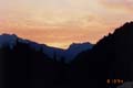
Night Photo 1 |
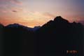
Night Photo 2 |
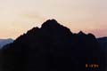
Night Photo 3 |
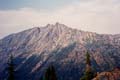
The Cradle |
Above The Valley |
Looking Down Valley |
Paddy-Go-Easy Pass |
Photo Page 2
Home