Tiger and Si Views
I began to hike regularly
after graduating from college in 1982. I hiked up Mt. Si several times
during college. In 1983 I discovered Tiger Mountain. Armed with Bill
Longwell's guide book I began to explore a few areas of Tiger. At that
time very few others hiked there regularly. It was not uncommon to see
3 or 4 cars at High Point on a sunny summer day. I took some pictures
from the tops of both Mt. Si and Tiger 1, 2, and 3 back at that time.
It's interesting to see how North Bend, Issaquah, and the surrounding
area have changed in the intervening 20 years.
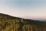
My favorite memory of Mt. Si was hiking up late one afternoon while in college and camping overnight. At that time there was no DNR conservation area and there were several camp sites. Bob and I cooked our dinner on the rocks overlooking North Bend and watched the sun set over Seattle. A woman slipped near the top and broke her ankle and a rescue party come through with a litter while we were eating. They carried her to the Teneriffe road to a waiting vehicle. One of the rescuers had a hang glider brought up with the rescue vehicle and we watched him soar off from the summit basin to a grassy field below just at sunset. At that time there was a downtown North Bend which had just lost I-90 to the bypass lanes and there was nothing at all at the main freeway exit. By nothing I mean a cloverleaf and grass. The 1980 census shows a population of 2,578. Other than the downtown area there was not much to see but farmland. Take a picture next time you are on the summit and compare it to the ones I have on this site.
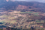
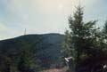
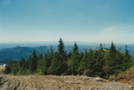
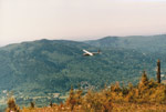
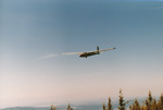
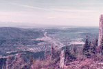
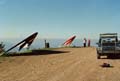
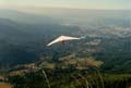
Tiger Mountain used to sit just above the tiny community of Issaquah. The 1980 population was 5,536. From the summit of Tiger 3 you could see down to Issaquah and out over Lake Sammamish. Those trees were 19 years younger and much smaller. To the north of I-90 there was virtually nothing. No office buildings, no strip malls, no pavement. The Pickering farm with it's grass airport was a mecca for sail planes. From the summit of Tiger you could see them soaring overhead. A favorite trick was to go behind Tiger 2 and dive down over the top of Tiger 3. The gliders were silent until they were nearly overhead, then they would appear just above your head, or so it seemed. There were some hang gliders at Poo Poo Point even then but I most enjoyed the gliders. I made a few hikes out to Poo Poo via the railroad grade through Many Creek Valley. It was more of a route than a trail. The hang glider pilots would drive right up to the edge of the point. It was a muddy area quite unlike the nice grassy runway that now exists. Without a constructed Chirico Trail very few people went to Poo Poo. Other parts of Tiger were quite different as well. Tiger 2 had one tower on top. Tiger 1 had several in one spot. Both of these antenna farms have grown rapidly and likely will continue to do so. One favorite spot was where the TMT intersected the trail to the top of Tiger 2 on the north side. There was a bench there with an unobstructed view north to Mount Baker and Mt. Pilchuck. Tree growth has minimized this view today.
The other side of Tiger had several nice trips. The road up to East Tiger was enclosed by a cathedral of trees part of the way. Recent logging has obliterated this wonderful road walk. I have no idea why every tree was removed at least 30' deep on both sides of the road. It is now an ugly scar to be hurried through not slowly enjoyed. As the population grows I am more and more thankful that Tiger Mountain Forest continues to exist. Rather than thousands of more homes we have a "wilderness" within Puget Sound City. It provides a close in place to get away from the crowds below. For this I am grateful. I will continue to complain about the changes that the enormous population boom has brought but I will also choose to continue living here and hiking Tiger Mountain and Mt. Si.
Click on thumbnails to see larger pictures.
Home
My favorite memory of Mt. Si was hiking up late one afternoon while in college and camping overnight. At that time there was no DNR conservation area and there were several camp sites. Bob and I cooked our dinner on the rocks overlooking North Bend and watched the sun set over Seattle. A woman slipped near the top and broke her ankle and a rescue party come through with a litter while we were eating. They carried her to the Teneriffe road to a waiting vehicle. One of the rescuers had a hang glider brought up with the rescue vehicle and we watched him soar off from the summit basin to a grassy field below just at sunset. At that time there was a downtown North Bend which had just lost I-90 to the bypass lanes and there was nothing at all at the main freeway exit. By nothing I mean a cloverleaf and grass. The 1980 census shows a population of 2,578. Other than the downtown area there was not much to see but farmland. Take a picture next time you are on the summit and compare it to the ones I have on this site.
Tiger Mountain used to sit just above the tiny community of Issaquah. The 1980 population was 5,536. From the summit of Tiger 3 you could see down to Issaquah and out over Lake Sammamish. Those trees were 19 years younger and much smaller. To the north of I-90 there was virtually nothing. No office buildings, no strip malls, no pavement. The Pickering farm with it's grass airport was a mecca for sail planes. From the summit of Tiger you could see them soaring overhead. A favorite trick was to go behind Tiger 2 and dive down over the top of Tiger 3. The gliders were silent until they were nearly overhead, then they would appear just above your head, or so it seemed. There were some hang gliders at Poo Poo Point even then but I most enjoyed the gliders. I made a few hikes out to Poo Poo via the railroad grade through Many Creek Valley. It was more of a route than a trail. The hang glider pilots would drive right up to the edge of the point. It was a muddy area quite unlike the nice grassy runway that now exists. Without a constructed Chirico Trail very few people went to Poo Poo. Other parts of Tiger were quite different as well. Tiger 2 had one tower on top. Tiger 1 had several in one spot. Both of these antenna farms have grown rapidly and likely will continue to do so. One favorite spot was where the TMT intersected the trail to the top of Tiger 2 on the north side. There was a bench there with an unobstructed view north to Mount Baker and Mt. Pilchuck. Tree growth has minimized this view today.
The other side of Tiger had several nice trips. The road up to East Tiger was enclosed by a cathedral of trees part of the way. Recent logging has obliterated this wonderful road walk. I have no idea why every tree was removed at least 30' deep on both sides of the road. It is now an ugly scar to be hurried through not slowly enjoyed. As the population grows I am more and more thankful that Tiger Mountain Forest continues to exist. Rather than thousands of more homes we have a "wilderness" within Puget Sound City. It provides a close in place to get away from the crowds below. For this I am grateful. I will continue to complain about the changes that the enormous population boom has brought but I will also choose to continue living here and hiking Tiger Mountain and Mt. Si.
 Mt. Si View |
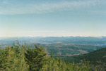 Grand Ridge View |
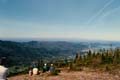 Tiger 3 Summit |
 Tiger 1 From TMT |
 Tiger 1 Summit |
 Glider From Tiger 3 |
 Glider Soars By |
 Repeater Tower |
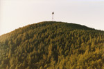 Tiger 2's Only Tower |
 Issaquah in 1984 |
 Poo Poo Point |
 Poo Poo Point View |
Home