11-03-02
The Walt Bailey Trail has been
on my to do list for at least half a dozen years. I had just never gotten
around to it. I finally made it up there and now I really wish I had done
it sooner. This is one of the nicest trails I have hiked in years. I seems
to be constantly turning right, left, up, or down. The route has meadows,
creeks, boulders, and some mighty fine lakes. The night before had record
low temperatures for the date in much of the Puget Sound area. I have driven
the Mountain Loop Highway when it's icy and it's not much fun. Still, I
took and chance and headed out. The first icy stretches were just beyond
Granite Falls. Several spots up the valley were very slick. I actually
went below the limit on the tight 20 mph curve. At Verlot a VW bug pulled
out right in front of me and as luck would have it I followed him all the
way to the trailhead. He took the last spot in the "lot" a short ways before
the trailhead. I was forced to backtrack another 1/4 mile. By 9:50 I was
on the trail. As I mentioned, this is a fun trail to hike. Walt Bailey and
his volunteers have done a better job than most Forest Service trails. The
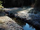
theme of the day was "ice". The plants were coated in white. The creeks were
uniformly frozen solid. Where there was water on the trail it was clear solid
ice. This was a bit of a problem as a careless step onto the ice could have
led to a nasty fall. I was extra careful to look for the ice. The sky was
blue but it was at or just below freezing. After climbing and following the
ridge the trail dropped down to meadows dotted with frozen tarns. There were
still quite a few huckleberries along this stretch. More like Hucklesicles
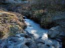
this morning. One good sized creek was frozen solid but I could hear water
moving underneath. Chips in the ice attested to failed attempts to break
it with some big rocks.
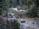
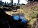
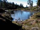
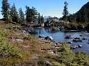
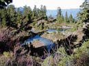
The trail dropped farther to near the head of a valley. All the logs, grass, and rocks here were coated with white. There was no new snow but a very heavy frost. I was a little surprised to see a significant amount of last years snow lasted all the way through Summer. The snow was only at about 3500'. The trail crossed to the other side of the narrow valley and wove through rocks and forest. Soon it began to switchback up the hillside. There are some steps but mostly it is nice trail as it heads higher. The trail reaches the lip of the basin and everything changes. The forest is replaced with meadowland and all of the many Cutthroat Lakes. These range from small tarns to a few good sized lakes. All of the smaller lakes are frozen solid. The biggest lake is mostly frozen. I have never seen so many frozen lakes at one time. With the bright blue sky and the peaks and trees reflecting in them it was very beautiful. From the basin I could see out and picked out Big Four, Vesper, and Three Fingers. Up a little higher, Mt. Pilchuck came into view. In the back of my mind was a hope that I could take a crack at Bald Mountain while I was up there. From the upper lake the mountain was right above. Since it was still early I decided to keep following the trail higher. This was a little difficult as there are many trails crisscrossing near the largest lake. Most go to picnic/campsites. I tried to stay on the most used trail and headed towards the gentle meadowed slopes to the left (east) of Bald Mountain. The trail now had some snow on it and it was progressively slicker. I followed the trail quite a ways above the lakes until I was as high as the ridge coming down off of Bald. Since the trail was still going higher and getting too slick for my taste, I headed cross country towards the ridge of Bald Mountain. The terrain was mostly heather with a few trees and some large boulders In short order I was on the ridge at exactly the spot where the trail heads around the south side of the mountain. There was a sign here telling about the scout troop who built this section of trail. As the trail turned to the south side all the snow disappeared. Suddenly I could see that the whole valley below was filled with Spada Lake. The trail headed across the south side and then switchbacked up to a ridge coming south from the summit. The trail continued around the mountain and began to descend. A less distinct route headed up towards the summit. At this point I saw another hiker near the bottom of a near vertical wall on the summit block. This route was way beyond my scrambling ability. I headed up hoping to ask the hiker if there was an easier route up. I met Terry part way up. He was heading down after not finding a good route up. I would much rather scramble with someone else and asked if he would try the east ridge with me. It didn't take much to get him to agree. We contoured to our right (east) and found some tread. Getting to the ridge was easy. From there large slabs went the last 50' or so to the top. This route is not really tough if you have scrambling experience.
There is a great view from the top. Spada is below to the south. Mt. Rainier was out but had a lenticular cap foretelling the end of our clear weather. Shuksan was to the north but Baker was behind Three Fingers and Whitehorse. It was interesting to see the south side of Big Four, Vesper, and Del Campo. Even Mt. Stuart was visible far to the southeast. All the Cutthroat Lakes were seen strewn across the meadows below. This was a great scramble that I will be back to do again. The hike down was fun. After dropping out of the basin I left the sun until I made it back to my car. From the trailhead you can't see Bald Mountain but from where I parked you can. It was interesting to see where I had actually been. I'm sure this is a great trip in the heat of summer and the berries and colors of fall. For my money it can't be better than when all the lakes are frozen over. This was a very memorable hike.