6-22-02
I set out to do an old favorite
which I had not done in 9 years. In the Spring this trip has a noisy creek,
great views, nice flowers, a terrific ridge walk, and a neat summit. The
day was forecast to be hot so I was on the road by 6:00 am and on the trail
by 8:00 am. The trailhead is up the North Fork Teanaway Road, just beyond
Beverly Campground. This is a hiker, horse, bicycle, and motorcycle trail.
It is best to do this trip when there is still enough snow to stop all but
hikers. The first 3/4 mile is nearly flat. At this point the Jungle Creek
trail branches off to the left. I kept right and continued to move up the
valley. There are 4 creek crossings. The first 2 were fairly easy. There
are rocks and small logs to help. The next 2 are a little more difficult.
The rocks are very slick. With poles and long legs I crossed with dry feet.
The water is not very deep so crossing is not at all dangerous. Now back
on the right side of the creek I continued up the valley. The first
2 1/4 miles are very gentle, gaining only about 200' per mile. I noticed
that there are many strawberry plants in bloom. When the fruit is ripe that
will be a great bonus for this trip. The berries are tiny but very sweet.
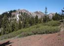
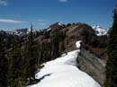
With the first switchback the trail changes radically. Now it's time to gain some elevation. In the next 1 3/4 miles I gained 1800' of the 2300' total to Medra Pass. The trail is Mt. Si steep the rest of the way. As elevation is gained the forest gives way to largely open slopes and some trees. The combination of horses and motorcycles means it's a dusty trail. The flowers continued at higher elevations. Even at 9:00 am it was getting hot. I would not want to be hiking up this part in the mid day sun. When the ridge was reached I encountered the first snow of the day. From the ridge the trail traverses left towards the pass. There were still 7 or 8 large snow patches. They were easy enough to cross but they completely stopped any motorcycles from advancing. Another one to two weeks and the trail will be bare to the pass. From Medra Pass Mt Stuart is clearly visible. Most of the other Teanaway peaks to the north are too. Iron Peak is right across the valley. On the other side of the pass Mt. Rainier is in sight. A trail crossed the pass and descends to the Middle Fork of the Teanaway. The old sheep driveway goes right and left. This route has not been maintained in many decades. The "trail" goes from good to nonexistent to good again. Be sure to have a map if you go in either direction.
I turned to the right and headed towards Koppen Peak. The pass is 5400' and the summit is 6031'. With ups and downs there is closer to 1000' gained out and back. Even though I successfully found my way to Koppen and back in 1993 I still made a mistake this time. At one point there is a main trail straight ahead and a smaller one turning right. The turn is the correct one. When I started descending and came to a cliff I smartly deduced that I had screwed up. The ridge over to the right looked much friendlier. I backtracked and found the correct turnoff. There is about 2 miles of ridge rambling to Koppen Mountain. The trail is either on the ridge top or just to the left of it. There was one large patch of yellow balsamroot and many other flowers along the way. The route is not one for trail hikers. Along with route finding there are several spots where you must traverse lose rock with little if any "trail". Those who are comfortable scrambling in these conditions should have no problem getting all the way to Koppen. Even if you stop short of the summit the views are great. Hawkins and Esmerelda dominate to the northwest. Point 5806 is the last high point before the summit. It is only about 200' lower than Koppen. After dropping down to a low point there is one last steep climb on grassy slopes to the top. Koppen sits in the center of a number of peaks. It is far enough away form any others to afford great views. Jolly Mountain, the peaks north of Snoqualmie Pass, Hawkins, Esmerelda, Mount Daniel, Fortune, Ingalls, Stuart, Iron, Teanaway, Earl, Navaho, and more are clearly seen. You can throw in Mt Rainier and Mt Adams for good measure. I was on top by 11:15 so I had plenty of time to enjoy the day. It was nearly calm on the way up but the wind began to pick up on top. Considering that my thermometer already read 80 degrees the wind was a blessing. I spent 2 full hours on top. One other hiker came up via the trail from Deroux to the north. He mentioned that the upper trail was still buried by snow and he just kicked steps up to the ridge top. The register showed that I was the 7th person and the 4th party to summit this year.
I took my time on the way down. The ridge is so much fun to travel that I didn't want to see it end. I was quite surprised to meet 2 horse riders. They proceeded much farther than I thought horses would go. They were from Winthrop and they told me about the Pasayten and I filled them in on the Teanaway. The rest of the trip down was fairly uneventful. By the time I reached the pass clouds began to come in. I was glad to see them as this was more sun than I have dealt with in nearly a year. Warm is good but I had had enough for this day. The stats were 11 miles and 3400' gained. I added about 100' with my detour. It was more crowded than I expected as I saw 1 hiker on the summit, 2 horse riders, and 2 motorcycles on the way out. As usual in the Teanaway, there were few bugs except for many butterflies on the summit.
Click on thumbnails to see larger pictures.
Photo Page 2
Home
With the first switchback the trail changes radically. Now it's time to gain some elevation. In the next 1 3/4 miles I gained 1800' of the 2300' total to Medra Pass. The trail is Mt. Si steep the rest of the way. As elevation is gained the forest gives way to largely open slopes and some trees. The combination of horses and motorcycles means it's a dusty trail. The flowers continued at higher elevations. Even at 9:00 am it was getting hot. I would not want to be hiking up this part in the mid day sun. When the ridge was reached I encountered the first snow of the day. From the ridge the trail traverses left towards the pass. There were still 7 or 8 large snow patches. They were easy enough to cross but they completely stopped any motorcycles from advancing. Another one to two weeks and the trail will be bare to the pass. From Medra Pass Mt Stuart is clearly visible. Most of the other Teanaway peaks to the north are too. Iron Peak is right across the valley. On the other side of the pass Mt. Rainier is in sight. A trail crossed the pass and descends to the Middle Fork of the Teanaway. The old sheep driveway goes right and left. This route has not been maintained in many decades. The "trail" goes from good to nonexistent to good again. Be sure to have a map if you go in either direction.
I turned to the right and headed towards Koppen Peak. The pass is 5400' and the summit is 6031'. With ups and downs there is closer to 1000' gained out and back. Even though I successfully found my way to Koppen and back in 1993 I still made a mistake this time. At one point there is a main trail straight ahead and a smaller one turning right. The turn is the correct one. When I started descending and came to a cliff I smartly deduced that I had screwed up. The ridge over to the right looked much friendlier. I backtracked and found the correct turnoff. There is about 2 miles of ridge rambling to Koppen Mountain. The trail is either on the ridge top or just to the left of it. There was one large patch of yellow balsamroot and many other flowers along the way. The route is not one for trail hikers. Along with route finding there are several spots where you must traverse lose rock with little if any "trail". Those who are comfortable scrambling in these conditions should have no problem getting all the way to Koppen. Even if you stop short of the summit the views are great. Hawkins and Esmerelda dominate to the northwest. Point 5806 is the last high point before the summit. It is only about 200' lower than Koppen. After dropping down to a low point there is one last steep climb on grassy slopes to the top. Koppen sits in the center of a number of peaks. It is far enough away form any others to afford great views. Jolly Mountain, the peaks north of Snoqualmie Pass, Hawkins, Esmerelda, Mount Daniel, Fortune, Ingalls, Stuart, Iron, Teanaway, Earl, Navaho, and more are clearly seen. You can throw in Mt Rainier and Mt Adams for good measure. I was on top by 11:15 so I had plenty of time to enjoy the day. It was nearly calm on the way up but the wind began to pick up on top. Considering that my thermometer already read 80 degrees the wind was a blessing. I spent 2 full hours on top. One other hiker came up via the trail from Deroux to the north. He mentioned that the upper trail was still buried by snow and he just kicked steps up to the ridge top. The register showed that I was the 7th person and the 4th party to summit this year.
I took my time on the way down. The ridge is so much fun to travel that I didn't want to see it end. I was quite surprised to meet 2 horse riders. They proceeded much farther than I thought horses would go. They were from Winthrop and they told me about the Pasayten and I filled them in on the Teanaway. The rest of the trip down was fairly uneventful. By the time I reached the pass clouds began to come in. I was glad to see them as this was more sun than I have dealt with in nearly a year. Warm is good but I had had enough for this day. The stats were 11 miles and 3400' gained. I added about 100' with my detour. It was more crowded than I expected as I saw 1 hiker on the summit, 2 horse riders, and 2 motorcycles on the way out. As usual in the Teanaway, there were few bugs except for many butterflies on the summit.
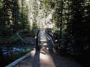
Bridge Over Teanaway |
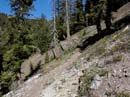
Trail Going Up To Pass |
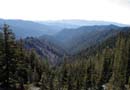
Valley From Pass |
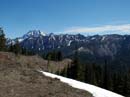
Stuart From Pass |
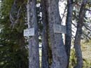
Trail Signs At Pass |
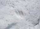
Paw Print |
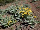
Balsamroot |
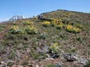
Balsamroots & Stuart |
Ridge and Summit |
Koppen & Point 5806 |
Photo Page 2
Home