6-29-02
Gary and I had done a few easy
mountain bike approaches for hikes. This time we wanted to try an approach
with some real elevation gain. It turned out to be a whole lot harder than
we guessed. The plan was to ride a gated road nearly over Iron Mountain
and down into the Negro Creek valley. From there the trail up to the lookout
site on Three Brothers is met. We sat at the lookout site a few years ago
and dreamed up this crazy idea. The route starts near the northern end of
the old Blewett Pass highway. The maps and reality do not match. We quickly
passed a gated road not shown on the map with a sign allowing every conveyance
known to man to proceed. Motorcycles, ORVs, snowmobiles, bikes, and hikers
are allowed. The map showed the gate we wanted to be 2 1/2 miles from the
Blewett turnoff. We went 4 miles and found nothing. We backtracked to the
first gate and decided to start here even though we had no idea where this
was on the map. It's one thing to get lost in the woods, it's another to
not even know where you started from. This road started out fairly steep
and loose. I was not having any fun at all. After doing more walking than
riding it moderated a little. A few miles up we came to a "Y" where the right
road was gated and the left not. The left looked like it was more heavily
used. Our map showed a "Y" up several miles so we chose to go left. This
proved to be both a mistake and a blessing. The left road continued to gain
elevation as it contoured around a deep valley. I found biking to be aerobically
10 times more demanding than hiking. I can gain 4500' hiking without getting
out of breath. Five minutes of steep biking had me panting. This was at a
blistering 4 mph. Thankfully it was partly cloudy and windy. At least it
wasn't painfully hot as well.
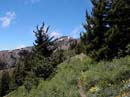
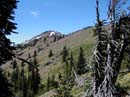
The road reached the end of the valley and contoured all the way around from the right side to the left. We saw a pass ahead and thought our climbing was about done. No such luck. Instead we began a series of switchbacks. climbing towards the head of the valley. We were now doing more riding than pushing. Across the valley we saw another road parallel and above the road we biked. Hmm... It sure looked like it was going near the summit of a peak that looked like Iron Mountain. Oh well, back to our route. The road reached the ridge top and intersected a hiking trail. I have hiked just about every trail in the Teanaway area. Where the heck were we? The trail went steeply uphill in both directions and I had no desire to try to bike it. Instead we stashed the bikes and prepared for some hiking. We turned right on the trail and headed up. Very shortly a peak came into view that was very familiar. We had also seen it lower down on the road for a brief moment. It was now clear to me that we were looking at Miller Peak. The peak behind us was Iron Bear. Now we knew exactly where we were. Gary pulled out his map and in a few minutes figured everything out. 1/2 mile from pavement the main road goes straight and another road turns off to the left. Actually, The 90 degree gated right turn we started at is the straight ungated road on the map. The "Y" with a gate at 2 1/2 miles where we turned left is the road up Iron Mountain and into Negro Creek. The good news is that road is much steeper than the one we climbed and we did not go on it. I may well have died trying to get up it or crashed coming down. I'm glad we accidentally missed it.
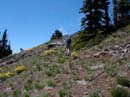
Now that we knew where we were it was obvious that Miller rather than Three Brothers was the objective for the day. The trail is completely snow free except for a large snow patch just below Miller. This is enough to keep motorcycles from completing the loop for another week or two. We followed the County Line trail towards Miller along a grassy, flower filled slope. Balsam root, paintbrush, scarlet gillia, and larkspur to name a few. As we approached Miller we headed up to the ridge top on steep but easy terrain. By now my legs were fairly sore from the biking section. It seems that we used some new muscles for biking. Interestingly, when hiking steeply uphill our legs felt better. After a nice ridge walk we came to the final steep climb to the summit. There is still some snow here but it was easy to avoid. At long last we reached the summit. By now the sun was completely out and the winds were getting very strong. It was nearly July in Eastern Washington with the mid day sun blaring down and we were still cold. We crouched down behind the summit rocks and bundled up. From here it was easy to see the whole route we had planned on. It was now painfully obvious that it was more than we could have accomplished in one day. The Three Brothers route would require biking up 2400' then down 1200'. Then you just need to hike up 3100' and down. Follow that with a bike climb back up that 1200' and a steep ride back to the cars. The route we stumbled into proved to be much more realistic for a couple of rookie bikers. From Miller it was an easy hike back down to the bikes.
The last section was the one we were a little nervous about. We didn't have any experience riding down a steep rocky road. At this point we had no choice but to go for it. The ride down turned out to be lots of fun. It was a whole lot faster as well. In 48 minutes we rode the full 6 1/2 miles back to the car. I guess it's an adventure when you don't know where you started or where you will end up. This trip worked out very well. Now for the totals: 13 miles biked with 2400' gained. 4 miles hiked with 1200' gained. All totaled that's 17 miles and 3600' gained. Not a bad day's work.
Click on thumbnails to see larger pictures.
Photo Page 2
Home
The road reached the end of the valley and contoured all the way around from the right side to the left. We saw a pass ahead and thought our climbing was about done. No such luck. Instead we began a series of switchbacks. climbing towards the head of the valley. We were now doing more riding than pushing. Across the valley we saw another road parallel and above the road we biked. Hmm... It sure looked like it was going near the summit of a peak that looked like Iron Mountain. Oh well, back to our route. The road reached the ridge top and intersected a hiking trail. I have hiked just about every trail in the Teanaway area. Where the heck were we? The trail went steeply uphill in both directions and I had no desire to try to bike it. Instead we stashed the bikes and prepared for some hiking. We turned right on the trail and headed up. Very shortly a peak came into view that was very familiar. We had also seen it lower down on the road for a brief moment. It was now clear to me that we were looking at Miller Peak. The peak behind us was Iron Bear. Now we knew exactly where we were. Gary pulled out his map and in a few minutes figured everything out. 1/2 mile from pavement the main road goes straight and another road turns off to the left. Actually, The 90 degree gated right turn we started at is the straight ungated road on the map. The "Y" with a gate at 2 1/2 miles where we turned left is the road up Iron Mountain and into Negro Creek. The good news is that road is much steeper than the one we climbed and we did not go on it. I may well have died trying to get up it or crashed coming down. I'm glad we accidentally missed it.
Now that we knew where we were it was obvious that Miller rather than Three Brothers was the objective for the day. The trail is completely snow free except for a large snow patch just below Miller. This is enough to keep motorcycles from completing the loop for another week or two. We followed the County Line trail towards Miller along a grassy, flower filled slope. Balsam root, paintbrush, scarlet gillia, and larkspur to name a few. As we approached Miller we headed up to the ridge top on steep but easy terrain. By now my legs were fairly sore from the biking section. It seems that we used some new muscles for biking. Interestingly, when hiking steeply uphill our legs felt better. After a nice ridge walk we came to the final steep climb to the summit. There is still some snow here but it was easy to avoid. At long last we reached the summit. By now the sun was completely out and the winds were getting very strong. It was nearly July in Eastern Washington with the mid day sun blaring down and we were still cold. We crouched down behind the summit rocks and bundled up. From here it was easy to see the whole route we had planned on. It was now painfully obvious that it was more than we could have accomplished in one day. The Three Brothers route would require biking up 2400' then down 1200'. Then you just need to hike up 3100' and down. Follow that with a bike climb back up that 1200' and a steep ride back to the cars. The route we stumbled into proved to be much more realistic for a couple of rookie bikers. From Miller it was an easy hike back down to the bikes.
The last section was the one we were a little nervous about. We didn't have any experience riding down a steep rocky road. At this point we had no choice but to go for it. The ride down turned out to be lots of fun. It was a whole lot faster as well. In 48 minutes we rode the full 6 1/2 miles back to the car. I guess it's an adventure when you don't know where you started or where you will end up. This trip worked out very well. Now for the totals: 13 miles biked with 2400' gained. 4 miles hiked with 1200' gained. All totaled that's 17 miles and 3600' gained. Not a bad day's work.
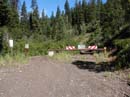
Trailhead |
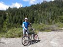
Gary And Bike |
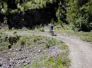
Gary Riding |
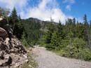
Walking The Bikes |
Miller In The Distance |
Miller Closer Up |
Climbing To The Ridge |
Photo Page 2
Home