9-01-02
When Clyde and I decided to meet
at Lake Tahoe I hunted around for a good hike near by. The most interesting
one I found was Mt Tallac. Tallac sits just to the south of the lake and
is the highest of the peaks around the rim of the lake. The trailhead is
at 6500', just a few hundred feet above the lake level. The summit is 9735'.
There are a number of trails which go to the summit. I chose the Mt. Tallac
trail. It is just over 9 miles round trip. The trail heads into the Desolation
Wilderness. It is quite crowded in the afternoon so we made sure to get
an early start. At 7:15 am there were only 3 other vehicles in the lot.
Forget about Trail Park permits, there is no charge to park. Wilderness
permits are required but they are unlimited and available at the trailhead.
Thanks to the internet, getting directions to the trailhead is easy.
The trail begins on an old road in a mostly pine forest. The way is fairly gentle for the first 2+ miles. After a short way the trail ascends to the top of a forested ridge. To the left is Falling Leaf Lake. If not for Lake Tahoe just a short distance away, this would be an enormous mountain lake. The lake is large enough to have a marina on it's shore. To the right are the first glimpses or the summit of Mt. Tallac. The trail drops slightly then climbs to the shore of little Floating Leaf Lake. The morning was calm and left a nice reflection of the summit in the lake. Unlike the Northwest, we were now at about 7200' and still in the forest. After the lake the trail continues at a nice grade on up to Cathedral Lake. This is really more like Cathedral Pond. It is very small but is very nice with trees and rocks around it. After the lake the real work begins. Clyde has not done much hiking and I was a little nervous about the steep section but he had no trouble at all. The trail breaks out of the forest and into a steeper hillside of grasses, rock, and some trees. Views out to Tahoe and surrounding peaks begin here as well. The summit is now seen far above. The trail meanders up the mountain without many switchbacks. I was very glad to be here in the early morning. It would be much tougher in the afternoon sun. The way eases shortly in an upper meadow then begins the last climb to the ridge top. This is the steepest part of the trip. From Cathedral Lake to the ridge is about one mile and 1000' gained.
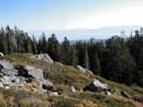
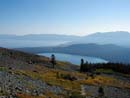
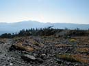
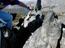
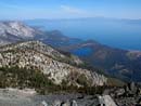
I was quite surprised by the terrain on the ridge top. The south side of the mountain is much more gentle than the north. The ridge slopes gently down in a large meadow with some good sized trees. Gilmore Lake and larger meadows are farther below. We were buzzed by a helicopter on the ridge which nearly touched down close by. The ridge top is at about 8600'. From here we had a little over 1100' to go. To the south the views are spectacular. Peaks of 9000' to near 11000' dot the skyline. The higher you go the better the views, including more and more lakes below. The final section stays below the now rocky ridge on the south side. I was curious to see how the elevation would affect me. Having spent 36 hours at 6200' to 8900', I was pleasantly surprised to see that the thin air was not very much of a problem. I don't know if I was able to gain much benefit from the acclimatization but I was glad to keep going at over 9000'. Once we were below the summit the trail from Gilmore Lake met our trail. From there the route left the trees and moved onto rock as it headed to the ridge. The last few hundred feet are on slabs and broken rock to the summit. The views from the top are fantastic. One hiker was leaving as we arrived so we had the summit to ourselves for about 20 minutes. We spent about 40 minutes on top. The sky was blue and cloudless. Fallen Leaf Lake was now far below. Emerald Bay loomed in deep blue below. To the south, above Gilmore Lake, is a granite ringed lake which is reminiscent of the Enchantment Lakes of Washington. The lake is in a barren cirque at about 8100'. Beware of the chipmunks on the summit. They are as aggressive as Camp Robber Jays. Four more hikers arrived and we stayed another 20 minutes. When even more neared the summit we headed down. The crowd coming up was growing rapidly. We passed at least 40 more people while descending. The route is steep in places and somewhat rocky but overall it was a better trail than I expected. The descent is not too tough on the legs. We stopped for a break at Cathedral Lake on the way down. It was getting hot now but most of the rest of the descent was in forest.
Back at the trailhead the lot was more than full. Cars were parked for quite a distance down the road. It was great to see Clyde and to get in a fun hike. I could have spent weeks hiking the Sierras of the South Lake Tahoe area. Unfortunately, I had to get back to Seattle. We took 2:39 minutes up with several short stops along the way. The return took a little under 2 hours. If you are in this area I would highly recommend a trip up Mt Tallac.
The trail begins on an old road in a mostly pine forest. The way is fairly gentle for the first 2+ miles. After a short way the trail ascends to the top of a forested ridge. To the left is Falling Leaf Lake. If not for Lake Tahoe just a short distance away, this would be an enormous mountain lake. The lake is large enough to have a marina on it's shore. To the right are the first glimpses or the summit of Mt. Tallac. The trail drops slightly then climbs to the shore of little Floating Leaf Lake. The morning was calm and left a nice reflection of the summit in the lake. Unlike the Northwest, we were now at about 7200' and still in the forest. After the lake the trail continues at a nice grade on up to Cathedral Lake. This is really more like Cathedral Pond. It is very small but is very nice with trees and rocks around it. After the lake the real work begins. Clyde has not done much hiking and I was a little nervous about the steep section but he had no trouble at all. The trail breaks out of the forest and into a steeper hillside of grasses, rock, and some trees. Views out to Tahoe and surrounding peaks begin here as well. The summit is now seen far above. The trail meanders up the mountain without many switchbacks. I was very glad to be here in the early morning. It would be much tougher in the afternoon sun. The way eases shortly in an upper meadow then begins the last climb to the ridge top. This is the steepest part of the trip. From Cathedral Lake to the ridge is about one mile and 1000' gained.
I was quite surprised by the terrain on the ridge top. The south side of the mountain is much more gentle than the north. The ridge slopes gently down in a large meadow with some good sized trees. Gilmore Lake and larger meadows are farther below. We were buzzed by a helicopter on the ridge which nearly touched down close by. The ridge top is at about 8600'. From here we had a little over 1100' to go. To the south the views are spectacular. Peaks of 9000' to near 11000' dot the skyline. The higher you go the better the views, including more and more lakes below. The final section stays below the now rocky ridge on the south side. I was curious to see how the elevation would affect me. Having spent 36 hours at 6200' to 8900', I was pleasantly surprised to see that the thin air was not very much of a problem. I don't know if I was able to gain much benefit from the acclimatization but I was glad to keep going at over 9000'. Once we were below the summit the trail from Gilmore Lake met our trail. From there the route left the trees and moved onto rock as it headed to the ridge. The last few hundred feet are on slabs and broken rock to the summit. The views from the top are fantastic. One hiker was leaving as we arrived so we had the summit to ourselves for about 20 minutes. We spent about 40 minutes on top. The sky was blue and cloudless. Fallen Leaf Lake was now far below. Emerald Bay loomed in deep blue below. To the south, above Gilmore Lake, is a granite ringed lake which is reminiscent of the Enchantment Lakes of Washington. The lake is in a barren cirque at about 8100'. Beware of the chipmunks on the summit. They are as aggressive as Camp Robber Jays. Four more hikers arrived and we stayed another 20 minutes. When even more neared the summit we headed down. The crowd coming up was growing rapidly. We passed at least 40 more people while descending. The route is steep in places and somewhat rocky but overall it was a better trail than I expected. The descent is not too tough on the legs. We stopped for a break at Cathedral Lake on the way down. It was getting hot now but most of the rest of the descent was in forest.
Back at the trailhead the lot was more than full. Cars were parked for quite a distance down the road. It was great to see Clyde and to get in a fun hike. I could have spent weeks hiking the Sierras of the South Lake Tahoe area. Unfortunately, I had to get back to Seattle. We took 2:39 minutes up with several short stops along the way. The return took a little under 2 hours. If you are in this area I would highly recommend a trip up Mt Tallac.
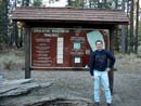
Trailhead |
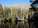
Floating Leaf Lake |
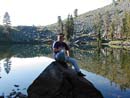
Cathedral Lake |
Above Lake |
Fallen Leaf Lake |
Copter At Ridge |
Chipmunk |
Emerald Bay |
Photo Page 2
Home