8/28-31/03
I had never been to Buck Creek
Pass but it had been on my list for years. Gary had been twice but not
in more than a dozen years. We originally planned on a Saturday - Monday
trip but changed it to Friday - Sunday at the last minute. We hoped to
miss some of the weekend crowds and all of the Highway 2 Monday traffic.
I worked in the morning and so didn't leave until about 11:15. With only
a little traffic slowdown near Monroe that was heading to the fair. We pulled
into the Chiwawa parking lot at 2:30 and were on the way at 2:45. The trail
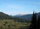
is gently graded the whole way, gaining 3200' over 9 1/2 miles. I was surprised
by the number of creeks still running in the lower valley. This is a horse
trail and as such is as dusty as any trail I have hiked. In places the sand
is 3-6 inches deep. In other places it is minimal. We hiked together most
of the way but several times I had to fall behind as I breathed in clouds
of dust Gary was stirring up. At 2 3/4 miles we crossed the Chiwawa River
on a big bridge. The river is little more than a creek this late in the
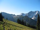
year. The trail is largely in forest but often moves out into the open.
The afternoon sun was very warm but the forest stretches and the gentle
grade allowed us to keep up a consistent pace. At about 7 miles the trail
makes a long switchback right then left. From there it is a traverse all
the way to the pass. The trail now is largely in the open with views of the
peaks above. The sun had dropped below the ridge and it was much cooler here.
We met two people finishing a loop trip and a single hiker heading up. Helmet
Butte loomed directly above us as we contoured around it towards the pass.
The trail goes above Buck Creek Pass and we took a side trail down to the
pass. There was one large and loud group and another small group camped.
That was it. The start of a holiday weekend, and a sunny one at that, and
we were only the third group at the pass. After 9 1/2 miles nearly non stop
we were beat. We set up camp and went for water. Buck Creek is still flowing
right at the pass. Closer to our camp we found the source of the creek. The
water bubbles out of the ground and drops several feet to the ground. This
was a perfect place to fill water bags. The water was nearly freezing right
out of the ground. I have seldom ever felt such cold water. It was numbing.
We arrived at 6:45 and by the time everything was set up and we were ready
for dinner it was getting dark. I managed to spill my freeze dried rice dinner
on the ground and had to scoop up as much as possible before adding water.
Rice and twigs is not my favorite flavor but I gulped it all down. As I started
to eat my metal spoon broke in half. Twiggy food and a 3 inch spoon. What
a combination. The trip was off to a great start. As we sat in the dark after
dinner a strange apparition appeared. With our headlamps we saw two sets
of glowing white dots moving towards us. This looked like something out of
a horror movie. The dots turned out to be deer with just a light silhouette
and those glowing eyes. We were to see much more of this each evening. By
10:30 we were off to bed.
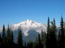
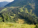
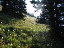
I woke up at 6:00 but it was after 7:00 before I crawled out of bed. It was too late to hike to a sunrise view of Glacier Peak. The view the previous night from above the pass was all washed out. The pass itself is meadows and forest with no views out except straight up to Helmet Butte to the north and Liberty Cap to the south. By 8:15 it had warmed up considerably and we were off to High Pass. The trail switchbacks up then contours around the west side of Liberty Cap. Once above the pass the way is along open meadowed hillsides. The view of Glacier Peak is stunning. The pass is at 5800' and we quickly climbed to 6500'. Glacier is right in your face. This side is much more ice and snow covered than the opposite side we saw from White Mountain last month. The valley of the Suiattle River was below us as it corkscrews around 2/3 of the mountain. Fortress Mountain came into view to the right of Helmet Butte. To the north in the vicinity of Snowking we saw dark smoke covering the peaks. It looked like a pretty serious fire up that way. I have not yet been up on Miners Ridge but it was clearly visible. We could even see the lookout on top. Most flowers are finished this year but we had several stunning displays of fireweed. With the flowers gone most of the bugs are too. Even in camp they were not much of a bother. The trail contours around Liberty Cap and a way trail goes up the southeast side. The trail reaches the ridge here and continues around the south side. When it again reaches the ridge it switches to to the north side. Now we were looking down on the valley of Buck Creek. We saw much of the trail up where it was out of the forest. There were a few places where rock slides went across the trail and we easily scrambled across. Ahead we could then see the pass which signifies the end of actual trail. We hit the ridge above the pass and dropped down to it. The views to the north now included Clark Mountain and Napeequa Peak, both over 8000', and Mt. Berge just under. Below the pass is barren Triad Lake in a rock bowl. The nice gentle trail now is replaced with a steep path that climbs up the east side of the pass. From the next high point we could see Mt. Cleator above us and most of the route over to High Pass. It was 3 miles to the first pass and about 1 mile more to High Pass. The route took a descending traverse on minimal tread to a creek flowing down into Triad Lake. This is the only water between Buck Creek Pass and below the other side of High Pass. Be sure to fill water bottles here. We saw two hikers above us heading up Cleator. We also saw a tent on a bench all alone. Someone found a nice camp site. We were amazed at the water flow from a spring this high up. Later we climbed high enough to see that there was a large snowfield tucked in above us that provided the water for that creek. It should provide permanent all year water there.
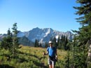
From the creek to High Pass is not far but there is no real trail. At first we crossed a small snow field that could be avoided if it were icy. Then the route is just a rocky talus field where the route remains fairly level. There is one obvious break in the cliffs and that is where we headed. The last section had snow to the side and it was a bit muddy with rocks and scree. At the top we were just above High Pass. Below the pass on the south side is a small lake. The pass is just about 7000'. From the pass we headed up to the top of a knoll then descended a little and climbed to the top of a higher one. Now it was time to make a decision. We had been looking at 8000'+ Napequa Peak for the last hour trying to decide if it looked like a reasonable scramble. Initially we had considered Buck Mountain but it became apparent that it was a hell of a long way from High Pass. The summit of Napeequa didn't look like much fun so we decided instead to follow the ridge up to the top of Point 7529. This just required dropping down to another pass and climbing up 600' on an open grassy slope. We reached the top at 12:15 and sat down to lunch. Cirque Peak was just behind us and Napeequa is next to it. That blocked our view to the southwest. Every other direction was wide open. The glaciers on Clark and Luhana to the south were impressive. The top of Glacier Peak stood out. To the north we saw Helmet Butte, Fortress, Bonanza, Chiwawa, Seven Fingered Jack, Mt. Maude, Red Mountain, Carne Mountain, and more. Gary scrambled Chiwawa last year and the south face route he took looks like a vertical cliff from Point 7529. We could now see the summit of Buck Mountain behind Mt. Berge. It was far enough away to confirm our plan to go there would have been far more than we were up for. From our vantage point we saw one person nearing High Pass and another leaving. We had seen several hikers from a distance but had met none so far. This spot was one of the best places I have been in the Cascades. Spectacular mountain views, meadow covered ridges, and a desolate lake right below us. The smoke to the northwest was really bad now. An entire ridge was lost in the haze. I was in no hurry to leave this place. I did drop down on the far side of the peak and scramble out to a rocky point. Cirque Mountain was very close here and the top looked like a reasonable scramble. Unfortunately the point I was on dropped down several hundred feet or more on three sides. It would have taken a lot of back tracking to get to a point right across from me on Cirque. I went back to the top of 7529 for more photos. After one hour on top we decided on a trip up Cleator on our return. Heading down to the pass we passed the one and only person we met all day. We had passed him nearing Buck Creek Pass the day before. He was interested in climbing Cirque and I told him what I had seen from above. I don't know if he made it up Cirque. We looked back with binoculars several times and never saw anyone on Cirque or Point 7529. Back up and over the humps and we were back at High Pass. We descended back to the creek and pumped water again. I managed to loosen a large sharp rock here and gouged my ankle. At least I have a first aid kit and taped on a bandage which stopped the bleeding. They say that bad luck runs in threes and after dumping my dinner and breaking my only utensil this was the third event. I guess it's true as nothing else bad occurred on the trip.
We climbed up from the creek and headed right up the slope towards the ridge coming down from the summit of Mt. Cleator. At the ridge we picked up a boot path straight up the mountain. It's like Bandera Mountain without the deep ruts. A steep hiking grade but quite a nice route. The top of Cleator is 7630'. It's 101 feet higher than our previous perch and includes a great view down to the Buck Creek Valley. We could see the pass and most of the valley. From here we could see around Mt. Berge to the summits of Buck Mountain. Once around Berge the rest of the route to the top looks very good. The day was very sunny but with a breeze it was very comfortable at 7630'. We were in no hurry to get back to camp. We spent a full hour on top of Cleator. While on top we saw two hikers heading our way. They were just approaching the first pass. Soon we saw a total of three. With binoculars we saw that they had full backpacks. They headed up from the pass then dropped down out of sight near the creek. Late they came back into view approaching High Pass. On our return we checked the sign in page and found a group of two doing the Buck Creek - Napeequa - Little Giant loop in three days. A soloist was doing it in two. That must have been the two groups hiking together. I hope that guy had a good time doing that whole loop in two days. At 4:30 we finally headed down. The trip back to camp was easy along the gentle trail. After dinner we sat and watched a huge reddish Mars rise in the eastern sky and the return of the glowing eyes.
Sunday morning I was ready to get up earlier and try to get some sunrise photos. We had decided to head over to Flower Dome for our photos. By 6:15 we headed out of camp. Amazingly there were exactly two other groups at the pass. A sunny Labor day weekend and we have two other groups both Friday and Saturday evening. I thought this was a crowded place. At least it wasn't for us. By the time we hiked up to the main trail the morning sun was just about to reach the summit of Glacier Peak. We knew we would not get to Flower Dome in time so we stopped right there and waited. As the sun rose the top of Glacier glowed while the rest of the mountain was a dull white. It was one of the most interesting sunrises I have seen. If we had bee even 10 minutes later we would have missed it. After this amazing show we headed over to Flower Dome. I would guess that it was about 1 mile to the top. There is a trail all the way. The top is a big flat meadow. It must be a blaze of color in season. We dropped a slight way below the top to get an unobstructed view of Glacier Peak. This is really a close up view. We saw Gamma Ridge, Vista Ridge, and Grassy Point just to the north of Glacier. It looks like some great country for on and off trail roaming. Miners Ridge was also very close now. Most surprisingly, the smoke and haze of the previous day was entirely gone. The view to the north was crystal clear. It's hard to believe that a fire putting out that much smoke could end that abruptly. Flower Dome proved to be a great place for early morning photos.
We headed back to camp, had breakfast, and packed up. The trip down was easy on the knees since the grade was so gentle. We passed a grand total of 6 hikers heading up the trail. So much for a crowed weekend. The trail was just as dusty as on the ascent. I was caked in dust by the time we made it out. At the Chiwawa bridge we were able to climb down to rocks right along the river. It was nice place to cool down and get a bite to eat. There is a creek right near the parking lot and we had been fixating on it much of the way down. Upon arriving we headed over to soak feet and clean off as much dirt and dust as possible. A cool creek and clean clothing is very refreshing. This proved to be a terrific backpacking trip. We were above tree line for nearly a whole day. Three easy summits with great views. The weather was nearly perfect. My first trip to Buck Creek Pass was certainly no disappointment. The totals for the weekend were 31 miles with 7500' gained.
Click on thumbnails to get larger pictures.
Photo Page 2
Home
I woke up at 6:00 but it was after 7:00 before I crawled out of bed. It was too late to hike to a sunrise view of Glacier Peak. The view the previous night from above the pass was all washed out. The pass itself is meadows and forest with no views out except straight up to Helmet Butte to the north and Liberty Cap to the south. By 8:15 it had warmed up considerably and we were off to High Pass. The trail switchbacks up then contours around the west side of Liberty Cap. Once above the pass the way is along open meadowed hillsides. The view of Glacier Peak is stunning. The pass is at 5800' and we quickly climbed to 6500'. Glacier is right in your face. This side is much more ice and snow covered than the opposite side we saw from White Mountain last month. The valley of the Suiattle River was below us as it corkscrews around 2/3 of the mountain. Fortress Mountain came into view to the right of Helmet Butte. To the north in the vicinity of Snowking we saw dark smoke covering the peaks. It looked like a pretty serious fire up that way. I have not yet been up on Miners Ridge but it was clearly visible. We could even see the lookout on top. Most flowers are finished this year but we had several stunning displays of fireweed. With the flowers gone most of the bugs are too. Even in camp they were not much of a bother. The trail contours around Liberty Cap and a way trail goes up the southeast side. The trail reaches the ridge here and continues around the south side. When it again reaches the ridge it switches to to the north side. Now we were looking down on the valley of Buck Creek. We saw much of the trail up where it was out of the forest. There were a few places where rock slides went across the trail and we easily scrambled across. Ahead we could then see the pass which signifies the end of actual trail. We hit the ridge above the pass and dropped down to it. The views to the north now included Clark Mountain and Napeequa Peak, both over 8000', and Mt. Berge just under. Below the pass is barren Triad Lake in a rock bowl. The nice gentle trail now is replaced with a steep path that climbs up the east side of the pass. From the next high point we could see Mt. Cleator above us and most of the route over to High Pass. It was 3 miles to the first pass and about 1 mile more to High Pass. The route took a descending traverse on minimal tread to a creek flowing down into Triad Lake. This is the only water between Buck Creek Pass and below the other side of High Pass. Be sure to fill water bottles here. We saw two hikers above us heading up Cleator. We also saw a tent on a bench all alone. Someone found a nice camp site. We were amazed at the water flow from a spring this high up. Later we climbed high enough to see that there was a large snowfield tucked in above us that provided the water for that creek. It should provide permanent all year water there.
From the creek to High Pass is not far but there is no real trail. At first we crossed a small snow field that could be avoided if it were icy. Then the route is just a rocky talus field where the route remains fairly level. There is one obvious break in the cliffs and that is where we headed. The last section had snow to the side and it was a bit muddy with rocks and scree. At the top we were just above High Pass. Below the pass on the south side is a small lake. The pass is just about 7000'. From the pass we headed up to the top of a knoll then descended a little and climbed to the top of a higher one. Now it was time to make a decision. We had been looking at 8000'+ Napequa Peak for the last hour trying to decide if it looked like a reasonable scramble. Initially we had considered Buck Mountain but it became apparent that it was a hell of a long way from High Pass. The summit of Napeequa didn't look like much fun so we decided instead to follow the ridge up to the top of Point 7529. This just required dropping down to another pass and climbing up 600' on an open grassy slope. We reached the top at 12:15 and sat down to lunch. Cirque Peak was just behind us and Napeequa is next to it. That blocked our view to the southwest. Every other direction was wide open. The glaciers on Clark and Luhana to the south were impressive. The top of Glacier Peak stood out. To the north we saw Helmet Butte, Fortress, Bonanza, Chiwawa, Seven Fingered Jack, Mt. Maude, Red Mountain, Carne Mountain, and more. Gary scrambled Chiwawa last year and the south face route he took looks like a vertical cliff from Point 7529. We could now see the summit of Buck Mountain behind Mt. Berge. It was far enough away to confirm our plan to go there would have been far more than we were up for. From our vantage point we saw one person nearing High Pass and another leaving. We had seen several hikers from a distance but had met none so far. This spot was one of the best places I have been in the Cascades. Spectacular mountain views, meadow covered ridges, and a desolate lake right below us. The smoke to the northwest was really bad now. An entire ridge was lost in the haze. I was in no hurry to leave this place. I did drop down on the far side of the peak and scramble out to a rocky point. Cirque Mountain was very close here and the top looked like a reasonable scramble. Unfortunately the point I was on dropped down several hundred feet or more on three sides. It would have taken a lot of back tracking to get to a point right across from me on Cirque. I went back to the top of 7529 for more photos. After one hour on top we decided on a trip up Cleator on our return. Heading down to the pass we passed the one and only person we met all day. We had passed him nearing Buck Creek Pass the day before. He was interested in climbing Cirque and I told him what I had seen from above. I don't know if he made it up Cirque. We looked back with binoculars several times and never saw anyone on Cirque or Point 7529. Back up and over the humps and we were back at High Pass. We descended back to the creek and pumped water again. I managed to loosen a large sharp rock here and gouged my ankle. At least I have a first aid kit and taped on a bandage which stopped the bleeding. They say that bad luck runs in threes and after dumping my dinner and breaking my only utensil this was the third event. I guess it's true as nothing else bad occurred on the trip.
We climbed up from the creek and headed right up the slope towards the ridge coming down from the summit of Mt. Cleator. At the ridge we picked up a boot path straight up the mountain. It's like Bandera Mountain without the deep ruts. A steep hiking grade but quite a nice route. The top of Cleator is 7630'. It's 101 feet higher than our previous perch and includes a great view down to the Buck Creek Valley. We could see the pass and most of the valley. From here we could see around Mt. Berge to the summits of Buck Mountain. Once around Berge the rest of the route to the top looks very good. The day was very sunny but with a breeze it was very comfortable at 7630'. We were in no hurry to get back to camp. We spent a full hour on top of Cleator. While on top we saw two hikers heading our way. They were just approaching the first pass. Soon we saw a total of three. With binoculars we saw that they had full backpacks. They headed up from the pass then dropped down out of sight near the creek. Late they came back into view approaching High Pass. On our return we checked the sign in page and found a group of two doing the Buck Creek - Napeequa - Little Giant loop in three days. A soloist was doing it in two. That must have been the two groups hiking together. I hope that guy had a good time doing that whole loop in two days. At 4:30 we finally headed down. The trip back to camp was easy along the gentle trail. After dinner we sat and watched a huge reddish Mars rise in the eastern sky and the return of the glowing eyes.
Sunday morning I was ready to get up earlier and try to get some sunrise photos. We had decided to head over to Flower Dome for our photos. By 6:15 we headed out of camp. Amazingly there were exactly two other groups at the pass. A sunny Labor day weekend and we have two other groups both Friday and Saturday evening. I thought this was a crowded place. At least it wasn't for us. By the time we hiked up to the main trail the morning sun was just about to reach the summit of Glacier Peak. We knew we would not get to Flower Dome in time so we stopped right there and waited. As the sun rose the top of Glacier glowed while the rest of the mountain was a dull white. It was one of the most interesting sunrises I have seen. If we had bee even 10 minutes later we would have missed it. After this amazing show we headed over to Flower Dome. I would guess that it was about 1 mile to the top. There is a trail all the way. The top is a big flat meadow. It must be a blaze of color in season. We dropped a slight way below the top to get an unobstructed view of Glacier Peak. This is really a close up view. We saw Gamma Ridge, Vista Ridge, and Grassy Point just to the north of Glacier. It looks like some great country for on and off trail roaming. Miners Ridge was also very close now. Most surprisingly, the smoke and haze of the previous day was entirely gone. The view to the north was crystal clear. It's hard to believe that a fire putting out that much smoke could end that abruptly. Flower Dome proved to be a great place for early morning photos.
We headed back to camp, had breakfast, and packed up. The trip down was easy on the knees since the grade was so gentle. We passed a grand total of 6 hikers heading up the trail. So much for a crowed weekend. The trail was just as dusty as on the ascent. I was caked in dust by the time we made it out. At the Chiwawa bridge we were able to climb down to rocks right along the river. It was nice place to cool down and get a bite to eat. There is a creek right near the parking lot and we had been fixating on it much of the way down. Upon arriving we headed over to soak feet and clean off as much dirt and dust as possible. A cool creek and clean clothing is very refreshing. This proved to be a terrific backpacking trip. We were above tree line for nearly a whole day. Three easy summits with great views. The weather was nearly perfect. My first trip to Buck Creek Pass was certainly no disappointment. The totals for the weekend were 31 miles with 7500' gained.
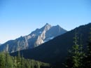
Buck Mountain |
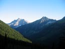
Buck And Cleator |
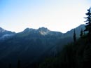
High Pass Trail |
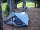
Campsite |
Smoke |
Glacier Peak |
Buck Creek Pass |
Gary On Trail |
Meadows & Pt. 7529 |
Western Anemone |
Photo Page 2
Home