9-27-03
This time of year there is a short
window when the fall colors are at their peak. Occasionally there will be
a sunny day to bring out those colors to their fullest. This weekend was shaping
up to be just such a time. Gary wanted to go to the far North Cascades and
I agreed. He chose Goat Mountain, not far from the border. The trailhead is
on the road to the Hannegan Pass trail. We wanted an early start for this
long drive. We met in North Seattle at 6:00 and we were on the trail by 8:30.
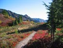
There were no other cars in the lot that early. The trail starts out great.
It switchbacks gently in dark forest. We gained 1200' in the first 2 miles
when I noticed the old trail to the lookout site. It has been covered over
with branches and is hard to see. It turns off right where the main trail
is traversing to the left. We considered hiking the half mile to the site
on the way back but after this day there was no chance of that happening.
As the trail begins to leave the forest it steepens but remains quite good.
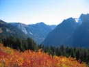
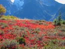
Views begin of Baker and Shuksan to the south. Also the colors start. They
start and never end. This was the best fall color hike I have ever done by
a wide margin. The sun backlit the bushes on the way up. On the way down it
had traversed the sky and backlit them again. Without the sunlight the colors
were dull but in it they were amazing. The trail climbed around a point and
followed a high ridge reminiscent of a small Sahale Arm. We could now see
the area of the summit of the west peak and also the east (highest) peak
of Goat Mountain. The slope steepened and the trail made a few switchbacks
before beginning a traverse to the left. At this point the nice trail deteriorated
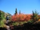
to a boot path. Above the trees are acres of open slopes that are just at
their colorful peak. It was hard to make much progress as I was continuously
snapping photos. The traverse ended and the route abruptly began to go straight
up. It was reminiscent of the "trail" up Bandera Mountain. It was steep but
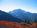
not difficult. When we reached the ridge top the views to the north popped
out. Yellow Aster Butte, Tomyhoi Peak, Canadian Border Peak, American Border
Peak, Winchester Peak with it's lookout, and Mt. Larabee to name a few. Snowcapped
peaks far off in Canada were also visible. The trail now followed the ridge
top to the right. There is lots of permanent ice to the north side of the
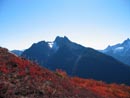
ridge. As we gained more elevation the west summit came into view. We traverse
around another bump on the ridge and the trail topped out on a nice large
point. Unfortunately the west summit was still 85' above us with a vertical
drop in between. For now we were happy to have lunch and soak up the views.
We had not seen anyone so far. Gary looked at the Gold Run Pass - Yellow Aster
Butte Trailhead and counted 27 cars. We seemed to have picked the place for
solitude. To here it was about 5+ miles with 4000' of gain. Our summit was
about 6640' and the west summit is 6725'.
After lunch we decided to try for the west summit. We could see that if we reached the saddle just below us it was an easy scramble to the top. We dropped back down to the ridge top and scrambled down a short distance to the snow below. There was a moat that led around but it looked nasty. Following the flat top of the snow left about a 20' drop on near vertical hard snow to the saddle. We went back and dropped down on gently sloped snow to where we had about a 50' traverse across very hard snow/ice to the saddle. Without ice axes and with some common sense we decided not to chance it. With crampons and an axe it would have been easy. If there were footprints to follow we may have tried. My motto is "live to scramble another day" and this did not look good. With the west summit denied we decided to try for the east summit. Our hope was to be able to follow the ridge from our lunch summit down to the saddle between the west and east summits. That quickly proved to be a false hope. We dropped down on the south side and began to traverse towards the saddle. The slope quickly became steeper and steeper. Small trees also obscured any view of what was ahead as well as promising many scrapes and bruises. With the way blocked we decided to go down to the meadows far below. The going was steep but within our abilities. We found a reasonable gully which took us much of the way down. Before reaching the meadow we found a slope than looked like it would save some distance and elevation loss. Thus began a long, long traverse on a steep hill side. This was more difficult than we expected as small ridges continuously blocked our views ahead. Some places did not go through and required going up or down to get by. Making matters harder was the lack of any shade on this open south slope as the forecast for 82 degrees seemed to be on target. Finally, the saddle came into view. It was not possible to drop down to the open slopes leading to the saddle. It was just too darn steep. Instead we had to traverse higher to hit the ridge well above the saddle where it was a tangle of dense trees. Once on the ridge it was a brush and limb bash down to the saddle, Many scratches later we made it. It was now 2:25 and we decided that we would have to be heading back by 3:30 to make it down before dark. I was not feeling up to par all day and by this point I knew there was not enough time for me to make the east summit. I was now in a cool shady spot with terrific views of peaks and valleys and had no intention of going anywhere for awhile.
Gary was still feeling strong and I suggested he go for the summit if he wanted to. We were at about 6100' at the saddle and the summit is only about 6850'. After a break Gary decided to go for it. I really enjoyed my rest and waited for his return. At about 3:15 he returned with bad news. He made it about 400' up but realized he would not make it up and down in time and headed back. From the pass we were reasonably confident that we could drop all the way down to the meadows at about 5400' then make our way back to the real trail at about 5500'. This is exactly what we did. By dropping lower we avoided much of the steep side hilling we did on the way over. The colors were spectacular all the way back. Of course there were a number of ups and downs that were not obvious from a distance but the going was not too bad at all. Our cross country route ended with a final 220' climb back to the trail along the ridge we had earlier ascended. It was 4:30 by now as it took one hour to come down from the saddle. The sun was now low in the west sky providing great back lighting for yet more photos of the fall colors. With photos and some berries to eat the progress was slow at first. When we reached the forest the grade eased and we speeded up. Just above the 2 mile mark we met a group with two small babies who were heading up. We figured to get out just before dark and suggested they plan to turn around soon. They had only one pack for 4 people so I hope flashlights were in there somewhere. In the dense forest it would be pitch black soon. I hope they made it out OK. We reached the car at exactly 6:30 as the sun was already behind the mountains. This was a phenomenal trip. The weather was great for the end of September. The views were great. We saw only two groups all day. And did I mention that the colors were unbelievable?
Click on thumbnails to get larger pictures.
Photo Page 2
Home
After lunch we decided to try for the west summit. We could see that if we reached the saddle just below us it was an easy scramble to the top. We dropped back down to the ridge top and scrambled down a short distance to the snow below. There was a moat that led around but it looked nasty. Following the flat top of the snow left about a 20' drop on near vertical hard snow to the saddle. We went back and dropped down on gently sloped snow to where we had about a 50' traverse across very hard snow/ice to the saddle. Without ice axes and with some common sense we decided not to chance it. With crampons and an axe it would have been easy. If there were footprints to follow we may have tried. My motto is "live to scramble another day" and this did not look good. With the west summit denied we decided to try for the east summit. Our hope was to be able to follow the ridge from our lunch summit down to the saddle between the west and east summits. That quickly proved to be a false hope. We dropped down on the south side and began to traverse towards the saddle. The slope quickly became steeper and steeper. Small trees also obscured any view of what was ahead as well as promising many scrapes and bruises. With the way blocked we decided to go down to the meadows far below. The going was steep but within our abilities. We found a reasonable gully which took us much of the way down. Before reaching the meadow we found a slope than looked like it would save some distance and elevation loss. Thus began a long, long traverse on a steep hill side. This was more difficult than we expected as small ridges continuously blocked our views ahead. Some places did not go through and required going up or down to get by. Making matters harder was the lack of any shade on this open south slope as the forecast for 82 degrees seemed to be on target. Finally, the saddle came into view. It was not possible to drop down to the open slopes leading to the saddle. It was just too darn steep. Instead we had to traverse higher to hit the ridge well above the saddle where it was a tangle of dense trees. Once on the ridge it was a brush and limb bash down to the saddle, Many scratches later we made it. It was now 2:25 and we decided that we would have to be heading back by 3:30 to make it down before dark. I was not feeling up to par all day and by this point I knew there was not enough time for me to make the east summit. I was now in a cool shady spot with terrific views of peaks and valleys and had no intention of going anywhere for awhile.
Gary was still feeling strong and I suggested he go for the summit if he wanted to. We were at about 6100' at the saddle and the summit is only about 6850'. After a break Gary decided to go for it. I really enjoyed my rest and waited for his return. At about 3:15 he returned with bad news. He made it about 400' up but realized he would not make it up and down in time and headed back. From the pass we were reasonably confident that we could drop all the way down to the meadows at about 5400' then make our way back to the real trail at about 5500'. This is exactly what we did. By dropping lower we avoided much of the steep side hilling we did on the way over. The colors were spectacular all the way back. Of course there were a number of ups and downs that were not obvious from a distance but the going was not too bad at all. Our cross country route ended with a final 220' climb back to the trail along the ridge we had earlier ascended. It was 4:30 by now as it took one hour to come down from the saddle. The sun was now low in the west sky providing great back lighting for yet more photos of the fall colors. With photos and some berries to eat the progress was slow at first. When we reached the forest the grade eased and we speeded up. Just above the 2 mile mark we met a group with two small babies who were heading up. We figured to get out just before dark and suggested they plan to turn around soon. They had only one pack for 4 people so I hope flashlights were in there somewhere. In the dense forest it would be pitch black soon. I hope they made it out OK. We reached the car at exactly 6:30 as the sun was already behind the mountains. This was a phenomenal trip. The weather was great for the end of September. The views were great. We saw only two groups all day. And did I mention that the colors were unbelievable?
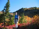
Gary And Colors |
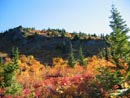
Entering Meadows |
Lower Meadows |
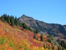
East Goat Mt. |
East To Mt. Sefrit |
Mt. Shuksan |
Mt. Sefrit |
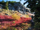
Bright Huckleberries |
Field Afire |
Meadows |
Photo Page 2
Home