10-4-03
Mt. Pugh is a scramble that has
been on my to do list for years. I finally crossed it off the list. Three
friends were going up. They met in Arlington for breakfast. I decided to
sleep in a little longer and still get an earlier start by missing the restaurant.
The day was forecast to be foggy by the Sound all day but sunny in the mountains.
The fog was fairly thick until Verlot but completely clear to the east.
There was one other car at the trailhead when I hit the trail at 8:20. It
was already warming towards the forecast high in the mid 70s. The lower
trail is terrific. There are no roots or rocks. The trail must be fairly
steep to gain 3800' in 4+ miles up to Stujack Pass but it doesn't seem so.
At 1 1/2 miles I reached Lake Metan. From the lake I could see above the
forest to the area of the summit. It looked every bit of 4000' above the
lake. The trail continues to climb at a reasonable rate with many switchbacks.
At about 4900' is a campsite at the end of the forest. Stujack Pass came
into view. The trail is a little poorer as it switchbacks up through talus,
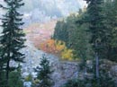
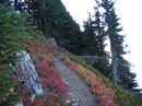
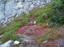
dirt, and gravel towards the pass. There was a little fall color along this
stretch but it wasn't great. I reached the pass at 10:45.
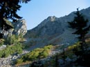
Once above the forest views began. They improved at the pass with easterly views added to those to the west. Whitehorse and Three Fingers were most obvious to the west. Low clouds and/or fog was below in the Stillaguamish valley up to about Darrington. Now the real fun began. I had heard and read much about the route from the pass to the summit. Some said it was a tough scramble with much exposure and others describe it as an easy trail. I think the truth is somewhere in the middle. It is not a difficult scramble but it is not a trail walk either. I thoroughly enjoyed it.
From the pass the trail switchbacks quickly up to the ridge top. There are small trees, lots of heather, and lots of rock. The trail reaches the narrow ridge section and crosses it on one side, the other, and along the top. There are spots with a considerable drop along here but the trail is wide enough for enough security. At one spot I saw the old tramway used to winch materials up to the summit for construction of the old lookout. After crossing the ridge I reached the first scramble section. The route has several scramble sections and ends with an easy walk to the summit. I found poles here left by the only person ahead of me. Both hands were needed for a short section. In the middle was a huge old bolt standing vertically in the rock. Above this the route reverted to a nice trail again. Several high points seem to be the real summit but are not. There is 1500' gained from the pass and it felt like at least that much. Although sketchy in places the route is not too tough to stay on. I contoured around another high point and startled a ptarmigan. It moved a few feet off of the trail and froze making for an easy photo opportunity. A few minutes later the real summit came into view. I saw the early hiker just starting down. Not long after passing him I reached the top. It was 11:50 and I was just in time for lunch. 3:30 up seemed to be a reasonable time for me. I was slowed a little by taking 40 photos from the pass to the summit.
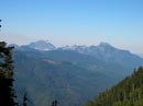
The views are outstanding from the summit. It was a little hazy this day and I can imagine how nice it would be on a perfectly clear day. Pugh is over 7200' and has no equally high peaks close by. Sloan is the closest peak that is higher. Glacier Peak finally was visible from the top. It is very bare. Whitechuck Mt. is to the north with Baker on one side and Shuksan on the other. I could pick out Big Four, Vesper, Sperry, and Del Campo to the south. El Dorado and Dome still had lots of ice showing on their south sides. I had about 15 minutes along before another hiker arrived. He had passed three others at Lake Metan so I was fairly sure that my friends were on the way but still a ways away. When he left I again had the summit to myself. Part of my reason for leaving early was to have a long summit stay before the others arrived. That's exactly how it worked out. At 1:00 Ed arrived. Emory was next and then John arrived. It may have been early October but it was quite warm. After that much work the guys had earned a rest and we stayed on top until about 1:50. I had a nice two hour stay.
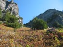
The climb down turned out to be much easier than I expected. Even the steep scramble spots were no problem. I went last to make it easier to take more photos. I really liked the upper sections of the mountain. It was mostly heather and bare rock with tremendous views of mountain peaks. We passed several more groups still coming up. It's a little bit of a knee grinder getting back down to the nice trail where it enters the forest. Still, it wasn't anywhere near the worst that I have done. We were in no hurry to get back to town and took our time coming down. We arrived back at the trailhead at 5:20. I took the road back via Darrington and by the time I reached it the low clouds were overhead and remained that way all the way home. It was a good day to be in bright sunshine above the clouds. This scramble proved to be all that I had hoped it would be. It's a fun route with great views along the way and especially on top.
Click on thumbnails to get larger pictures.
Photo Page 2
Home
Once above the forest views began. They improved at the pass with easterly views added to those to the west. Whitehorse and Three Fingers were most obvious to the west. Low clouds and/or fog was below in the Stillaguamish valley up to about Darrington. Now the real fun began. I had heard and read much about the route from the pass to the summit. Some said it was a tough scramble with much exposure and others describe it as an easy trail. I think the truth is somewhere in the middle. It is not a difficult scramble but it is not a trail walk either. I thoroughly enjoyed it.
From the pass the trail switchbacks quickly up to the ridge top. There are small trees, lots of heather, and lots of rock. The trail reaches the narrow ridge section and crosses it on one side, the other, and along the top. There are spots with a considerable drop along here but the trail is wide enough for enough security. At one spot I saw the old tramway used to winch materials up to the summit for construction of the old lookout. After crossing the ridge I reached the first scramble section. The route has several scramble sections and ends with an easy walk to the summit. I found poles here left by the only person ahead of me. Both hands were needed for a short section. In the middle was a huge old bolt standing vertically in the rock. Above this the route reverted to a nice trail again. Several high points seem to be the real summit but are not. There is 1500' gained from the pass and it felt like at least that much. Although sketchy in places the route is not too tough to stay on. I contoured around another high point and startled a ptarmigan. It moved a few feet off of the trail and froze making for an easy photo opportunity. A few minutes later the real summit came into view. I saw the early hiker just starting down. Not long after passing him I reached the top. It was 11:50 and I was just in time for lunch. 3:30 up seemed to be a reasonable time for me. I was slowed a little by taking 40 photos from the pass to the summit.
The views are outstanding from the summit. It was a little hazy this day and I can imagine how nice it would be on a perfectly clear day. Pugh is over 7200' and has no equally high peaks close by. Sloan is the closest peak that is higher. Glacier Peak finally was visible from the top. It is very bare. Whitechuck Mt. is to the north with Baker on one side and Shuksan on the other. I could pick out Big Four, Vesper, Sperry, and Del Campo to the south. El Dorado and Dome still had lots of ice showing on their south sides. I had about 15 minutes along before another hiker arrived. He had passed three others at Lake Metan so I was fairly sure that my friends were on the way but still a ways away. When he left I again had the summit to myself. Part of my reason for leaving early was to have a long summit stay before the others arrived. That's exactly how it worked out. At 1:00 Ed arrived. Emory was next and then John arrived. It may have been early October but it was quite warm. After that much work the guys had earned a rest and we stayed on top until about 1:50. I had a nice two hour stay.
The climb down turned out to be much easier than I expected. Even the steep scramble spots were no problem. I went last to make it easier to take more photos. I really liked the upper sections of the mountain. It was mostly heather and bare rock with tremendous views of mountain peaks. We passed several more groups still coming up. It's a little bit of a knee grinder getting back down to the nice trail where it enters the forest. Still, it wasn't anywhere near the worst that I have done. We were in no hurry to get back to town and took our time coming down. We arrived back at the trailhead at 5:20. I took the road back via Darrington and by the time I reached it the low clouds were overhead and remained that way all the way home. It was a good day to be in bright sunshine above the clouds. This scramble proved to be all that I had hoped it would be. It's a fun route with great views along the way and especially on top.
Fall Color |
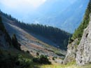
Stujack Pass |
Three Fingers & Whitehorse |
Climbing To Pass |
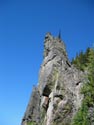
Rock "Tower" |
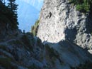
View Down From Pass |
Stujack Pass |
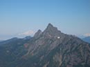
Whitechuck Mt. |
Color Above Pass |
Heather and Color |
Photo Page 2
Home