7/29 - 8/1/05
A trip to Miners Ridge has been in the planning for
Gary and I since the floods took out bridges and crowds via the Suiattle
River trail. Gary was last there 29 years ago and I had never visited. We
decided on a loop trip via Buck Creek ending through Spider Meadows and
the Phelps Creek trail. There is just over 3 miles of road between the two
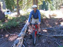
trailheads. I solved that problem with a quick trip to Value Village. I
did not want to leave my good mountain bike at the trailhead for 4 days so
I bought a used one for $14.95. One tire was flat and it only reached 4 of
the 12 gears but an evening of work fixed those problems. Friday morning we
drove to the Buck Creek trailhead near Trinity. I dropped off Gary and all
our gear and drove 700' up to the Phelps Creek trailhead. 16 minutes later
I bounced down the rocky road on a slightly too small bike with no suspension.
I chained it to a tree and by 9:45 we were on the trail.
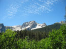
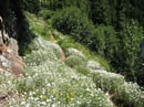
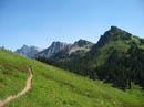
Heat is my nemesis on the trail and it was warming up rapidly. Both of us began the 4 day trip with about 25 lbs and with the light weight the hiking was easy. As we moved up the valley black flies became more and more apparent. They were not too bad while moving but a real problem if you stopped. We met several groups finishing the loop in the opposite direction than we chose. Their direction had 700' less elevation gain but we were able to begin with the downhill bike ride. The 9 1/2 miles to Buck Creek Pass was the only section of the trip I had done before. Our one water stop was ugly as a horde of biting flies descended on us. We pumped fast and got moving. Up near the pass the wind was blowing to cool us down and keep the bugs somewhat under control. The sky was completely clear and we had great views of Glacier Peak, Buck Mountain, Helmet Butte, and Fortress Peak. We climbed 3200' in 9 1/2 miles to 6000' near the pass.
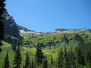
The next section was all downhill. The trail contours around Helmet Butte, passes a side trail to Flower Dome, and switchbacks down to a crossing of Small Creek at about 5100'. After an easy crossing the route begins the 1100' climb to the top of Middle Ridge. The ascent is in forest which had us out of the sun for the first time in several hours. At the ridge top we stopped for a break. There was an obscured view south through the trees but great views north to Miners Ridge. We could see miles of trail along the green hillside in the distance. It was now past 5:00 PM and we were startled to see a trail crew hiking up from north of Middle Ridge. They were on their way to camp higher on the ridge.
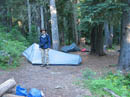
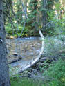
We planned to camp down at Miners Creek. Gary's 61 year old map showed the old trail to Miners Ridge. It went down Middle Ridge, across the creek, then up to the Miners Ridge trail. When the Pacific Crest Trail was built the old trail was abandoned beyond the PCT. The result is that the new trail gets to Miners Ridge in an extra 3 miles. We decided to try to follow the old trail and save some distance. The trail dropped off the north side of Middle Ridge with a long contour east in open meadows. Eventually if dropped into forest and continued to drop towards the creek. We reached the PCT junction at 4640'. On a tree across the PCT was a sign pointing to Miners Creek Camp. The route is overgrown but easily followed as it descends. It neared the creek which is in a narrow gorge and turned upstream to the right. There appeared to be nothing remotely flat when all of a sudden the route dropped down to a big flat bench along the creek. We had plenty of room for our tents and water was right there as well.
For the day we covered about 16 miles with 4300' of gain. We put up our tents, hung the food, and had dinner. The next question was if we could find the trail on the other side. The creek was much too wide and deep to rock hop across. It could be easily waded but I didn't want to end the day with wet feet. Instead, I shinnied across a narrow log to the other side. I searched for a few minutes and found wooden steps and the start of the trail. With that taken care of, I recrossed the creek and we called it a night.
Day 2
The second day began with more bright sunshine. We broke camp and I again shinnied across the log, this time with my full backpack. Gary had scouted out a log jam down stream and he chose that crossing. We met up on the other side and started up the overgrown trail. The old trail gains about 1000' in a little over a mile to the Miners Ridge trail near Glacier Peak Mines. It is very brushy with water running down sections and trees growing in the middle of it. It begins by staying low and heading downstream. Between the brush and trees we found it very hard to follow and decided to head straight uphill. There were no sticker bushes but there was thick brush and walls of small trees blocking the way. We took the path of least resistance which usually meant straight up or more to the right. This took us away from the actual trail route. We decided that trying to find the trail again was not worth it. After several hundred feet of tough bushwhacking Gary found a game trail which helped immensely.
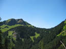
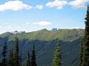
We found and lost game trails a number of times but they saved us a lot of time and likely lost blood. A little over an hour later we entered a sloping meadow and soon reached the Miners Ridge trail. I was happy to be done with the bushwhack. The old trail bushwhack worked well. It saved us 3 miles and over an hour of hiking. The trail is nearly flat at this point and we quickly reached the old cabin site at Glacier Peak Mines. We also passed the obvious blocked end of the old trail from the creek. It would be fun to try it from the top down sometime. A few minutes beyond the cabin we took the right forking trail up Miners Ridge. Forest switchbacks gave way to open meadows. The ridge is unbroken green from top to bottom. The view of Glacier Peak is overpowering. Flowers were mostly past their peak but there was still lots of color. The trail climbs gently then descends to Image Lake. We went around to the back side of the lake for the classic view of Glacier Peak above the lake.
We dropped down the short trail to the backpackers camp and found a secluded site. There was one other tent but no people. Without the Suiattle closure the lake would be mobbed on a sunny mid summer Saturday. We set up camp amid the bugs, packed daypacks, and headed out to explore. First we climbed from our 5900' camp to Point 6922 to the east of Image Lake. The view north was now added to the great view to the south. Dome Peak seemed close by. Canyon Lake was visible across the valley. Fortress and Chiwawa Peaks stood out. There was enough wind to lessen the swarm of biting flies. Plummer Peak was our destination and we could now see it far along the up and down crest of Miners Ridge.
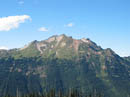
A boot path follows the crest and we followed it down and to the east. I love ridge top rambling and this is one of the best. There were no trees to block our view. On the next high point we could see Mt. Baker. Pugh and Three Fingers were to the west. We finally reached the base of Plummer Peak at about 7000'. The summit is 7870'. The ridge now steepened. The way was on heather, boulders, and scree. We contoured around the south side, dropping a little then climbing scree to easier heather leading up to the top. An easy rock scramble and we were on top.....of the false summit. Shoot, there was another peak just north that looked to be about 30' higher. We sat back and enjoyed outstanding views from our summit. Suiattle Pass, Cloudy Pass, and Spider Gap were visible. They were on the agenda for the next day. Bonanza Peak dominated to the northeast. Maude and Seven Fingered Jack were to the southeast. Chiwawa and Fortress were close by. This is a terrific summit.
We scoped out the route to the real summit. You must climb around our summit to the east, cross a saddle, then drop on scree before climbing up. We decided to take a look. We dropped from the summit and followed a narrow ledge. The last 20' to the saddle is on very loose scree with a several hundred foot fall if you slip. I kicked a rock loose and it fell, and fell, and fell. I expect this section is easy for a climber but I didn't want to come down it. We were perfectly happy to have nearly all the views from the lower summit. Rather than the long contour back we dropped down heather to the south with only a few scree and rocks fields to follow. We met up with the trail near where it comes out of the woods and followed it for the second time that day back to Image Lake. On our return we found the 89 year old wood carving of the Lady of the Woods Gary had read about.
After dinner we ended a great day with a mile walk over to the Miners Ridge Lookout. There we met Marc, Nancy, and Rayna who are manning the lookout for 30 days. In a strange irony they just moved after living 4 blocks from my house for many years. Their warm hospitality was much appreciated. We returned to camp just before dark. It was a long, busy, and fun day. The totals were 10 miles with 4400' gained.
Day 3
We headed out by retracing our path to Glacier Peak Mines and on towards Suiattle Pass. The trail is smooth and we made good time. We turned onto the Pacific Crest Trail and climbed towards the pass. We left the PCT on the hikers only trail to Cloudy Pass. It was anything but cloudy as we had our third straight warm and sunny day. From Suiattle Pass the trail drops then climbs along a steep wall before crossing over to a forested hillside. We switchbacked up and up to Cloudy Pass at 6438'. The day was easy so far so we decided to go ahead and have a try at Cloudy Peak. The biting flies were really awful at the pass. As nice as the view was we could not stay long and had to get moving. We left much gear near the pass and headed up with daypacks. A trail follows the ridge but we shortened the route by going cross country and scrambling back onto the ridge. The ridge up looks very steep from a distance but is not a particularly difficult scramble. It's mostly boulders and some loose scree.
The summit of Cloudy Peak is 7915'. As we climbed we noticed some white clouds near Spider Gap and wondered if the weather was changing. A few hundred feet below the summit Gary saw that those "clouds" were coming from a big forest fire. It was not far away and in the direction of my car. This was not something we planned for. We continued up but our whole trip was now in jeopardy. The going was good until we approached the summit block. It is a big pile of rock. We followed a ledge across the east side and I gingerly climbed a ramp to just north of the top. The most obvious route was a steep narrow gully/chimney I passed on the ramp. It was very exposed and not something I wanted to try down climbing. I very carefully climbed down the scree covered ramp back to the ledge. For the second day in a row we were stopped by a very exposed short climb. Again, most climbers would have gone right up it. To me, it was beyond a scramble as I looked down several hundred feet to the rock below. The view was about the same as we made it almost around the summit block.
Now we had to decide what to do about the fire. Gary pulled out his map and we drew a line from Cloudy Peak to where the fire appeared between Chiwawa and Red Mountains. It lined up perfectly with Trinity where we started. Only one mile from Trinity the road branches off to where my car was parked. If we hiked down to Lyman Lake then up to Spider Gap and out Spider Meadows we would be out of food and possibly find our route blocked by fire. The other option was to hike out to Holden and catch a ferry down Lake Chelan. With nothing to lose Gary pulled out his cell phone. He was unable to establish a connection. He then walked across the ramp 40' to the north and tried again. Amazingly he had a signal. It was weak but it was there. A few frantic calls later we were able to determine that the fire was indeed in line with Trinity but was farther south on Dirtyface Peak. We now had confidence that we would be able to get out via Spider Meadows.
After a huge sigh of relief we headed back to Cloudy Pass. From there we dropped down to Lyman Lake. We had been able to see Lower, Middle, and Upper Lyman from Cloudy Peak. They are beautiful lakes with a very greenish coloring. From Lyman a narrower but still good trail winds its way up the valley. The higher we went the more barren it became. Larch trees became much more prevalent. Near Suiattle Pass we met two backpackers and at the upper lake we saw another person at a distance. They were the only people we saw all day. Originally we planned to camp at the upper lake but had since decided to press on across Spider Gap. There are some cairns from the upper lake but mostly it was common sense navigation. Boulders and scree gave way to snow higher up. It was still soft enough from the sun to kick solid stops. If it were harder I would not have been comfortable without an ice axe. Hot sun beat down on us as we climbed to the pass but the other side was shaded and cool. The 7100' pass is as barren as anything I have seen.
The upper Spider Glacier was soft and we had a great time doing standing glissades down it. Farther down the glacier is a mess. There were deep holes with enormous hollow spaces under the ice. We moved to the far right side only getting on snow when necessary. Giant waterfalls cascaded down the steep walls above. In due time we made it off the ice and crossed the braided creek. We picked up the trail and found a campsite on a promontory overlooking the valley far below. We set up camp at about 6160' with an hour of daylight to spare. For the day we covered 12 miles gaining 4600'. That made for 38 miles and 13,300' gained in three days.
Day 4
After all the climbing the day before we were left with only 7 downhill miles to the car. It was just as well too since the weather changed very fast. I woke up to blue skies and the sun hitting the tops of Mt. Maude and Seven Fingered Jack. Less than an hour later the peaks were in dark clouds. Gray was all I could see overhead. On the positive side it was finally cool after three very hot days hiking largely above the tree line with little shade. We were on the trail by just after 8:00 AM. The trail is very improbable as it winds its way through the cliffs. It drops 850' in .60 miles to reach the valley floor below. For some strange reason the valley was not filled with bugs. We saw lots of marmots but hardly any bugs at all. There were many campers even though this was Monday morning. The rest of the hike out was just a gentle forest walk. We drove back to find the bike and helmet right where we left them. Several roads were closed and at one point near Lake Wenatchee we saw a line of 15 or more fire trucks heading to the blaze. As with all hikes in this area we finish it off with a stop at the 59er Diner.
This trip proved to be all that I expected and much more. The weather was terrific. The bugs were a nuisance but not unbearable. The meadows on Miners Ridge were among the best I have ever seen. The two scrambles didn't quite reach summits but were great fun and provided all the views that the last 15 or 30 feet would have. We crossed 4 passes, passed 4 lakes, and had views of more lakes and peaks than I can count. We camped alone the first and third nights and with only two other groups in the Image Lake basin. We also had a bushwhacking adventure and a real scare form the fire. For the four days we hiked 45 miles gaining 13,600' This was a trip I will long remember.
Click on thumbnails to get larger pictures.
Photo Page 2
Trips - 2005
Home
Heat is my nemesis on the trail and it was warming up rapidly. Both of us began the 4 day trip with about 25 lbs and with the light weight the hiking was easy. As we moved up the valley black flies became more and more apparent. They were not too bad while moving but a real problem if you stopped. We met several groups finishing the loop in the opposite direction than we chose. Their direction had 700' less elevation gain but we were able to begin with the downhill bike ride. The 9 1/2 miles to Buck Creek Pass was the only section of the trip I had done before. Our one water stop was ugly as a horde of biting flies descended on us. We pumped fast and got moving. Up near the pass the wind was blowing to cool us down and keep the bugs somewhat under control. The sky was completely clear and we had great views of Glacier Peak, Buck Mountain, Helmet Butte, and Fortress Peak. We climbed 3200' in 9 1/2 miles to 6000' near the pass.
The next section was all downhill. The trail contours around Helmet Butte, passes a side trail to Flower Dome, and switchbacks down to a crossing of Small Creek at about 5100'. After an easy crossing the route begins the 1100' climb to the top of Middle Ridge. The ascent is in forest which had us out of the sun for the first time in several hours. At the ridge top we stopped for a break. There was an obscured view south through the trees but great views north to Miners Ridge. We could see miles of trail along the green hillside in the distance. It was now past 5:00 PM and we were startled to see a trail crew hiking up from north of Middle Ridge. They were on their way to camp higher on the ridge.
We planned to camp down at Miners Creek. Gary's 61 year old map showed the old trail to Miners Ridge. It went down Middle Ridge, across the creek, then up to the Miners Ridge trail. When the Pacific Crest Trail was built the old trail was abandoned beyond the PCT. The result is that the new trail gets to Miners Ridge in an extra 3 miles. We decided to try to follow the old trail and save some distance. The trail dropped off the north side of Middle Ridge with a long contour east in open meadows. Eventually if dropped into forest and continued to drop towards the creek. We reached the PCT junction at 4640'. On a tree across the PCT was a sign pointing to Miners Creek Camp. The route is overgrown but easily followed as it descends. It neared the creek which is in a narrow gorge and turned upstream to the right. There appeared to be nothing remotely flat when all of a sudden the route dropped down to a big flat bench along the creek. We had plenty of room for our tents and water was right there as well.
For the day we covered about 16 miles with 4300' of gain. We put up our tents, hung the food, and had dinner. The next question was if we could find the trail on the other side. The creek was much too wide and deep to rock hop across. It could be easily waded but I didn't want to end the day with wet feet. Instead, I shinnied across a narrow log to the other side. I searched for a few minutes and found wooden steps and the start of the trail. With that taken care of, I recrossed the creek and we called it a night.
Day 2
The second day began with more bright sunshine. We broke camp and I again shinnied across the log, this time with my full backpack. Gary had scouted out a log jam down stream and he chose that crossing. We met up on the other side and started up the overgrown trail. The old trail gains about 1000' in a little over a mile to the Miners Ridge trail near Glacier Peak Mines. It is very brushy with water running down sections and trees growing in the middle of it. It begins by staying low and heading downstream. Between the brush and trees we found it very hard to follow and decided to head straight uphill. There were no sticker bushes but there was thick brush and walls of small trees blocking the way. We took the path of least resistance which usually meant straight up or more to the right. This took us away from the actual trail route. We decided that trying to find the trail again was not worth it. After several hundred feet of tough bushwhacking Gary found a game trail which helped immensely.
We found and lost game trails a number of times but they saved us a lot of time and likely lost blood. A little over an hour later we entered a sloping meadow and soon reached the Miners Ridge trail. I was happy to be done with the bushwhack. The old trail bushwhack worked well. It saved us 3 miles and over an hour of hiking. The trail is nearly flat at this point and we quickly reached the old cabin site at Glacier Peak Mines. We also passed the obvious blocked end of the old trail from the creek. It would be fun to try it from the top down sometime. A few minutes beyond the cabin we took the right forking trail up Miners Ridge. Forest switchbacks gave way to open meadows. The ridge is unbroken green from top to bottom. The view of Glacier Peak is overpowering. Flowers were mostly past their peak but there was still lots of color. The trail climbs gently then descends to Image Lake. We went around to the back side of the lake for the classic view of Glacier Peak above the lake.
We dropped down the short trail to the backpackers camp and found a secluded site. There was one other tent but no people. Without the Suiattle closure the lake would be mobbed on a sunny mid summer Saturday. We set up camp amid the bugs, packed daypacks, and headed out to explore. First we climbed from our 5900' camp to Point 6922 to the east of Image Lake. The view north was now added to the great view to the south. Dome Peak seemed close by. Canyon Lake was visible across the valley. Fortress and Chiwawa Peaks stood out. There was enough wind to lessen the swarm of biting flies. Plummer Peak was our destination and we could now see it far along the up and down crest of Miners Ridge.
A boot path follows the crest and we followed it down and to the east. I love ridge top rambling and this is one of the best. There were no trees to block our view. On the next high point we could see Mt. Baker. Pugh and Three Fingers were to the west. We finally reached the base of Plummer Peak at about 7000'. The summit is 7870'. The ridge now steepened. The way was on heather, boulders, and scree. We contoured around the south side, dropping a little then climbing scree to easier heather leading up to the top. An easy rock scramble and we were on top.....of the false summit. Shoot, there was another peak just north that looked to be about 30' higher. We sat back and enjoyed outstanding views from our summit. Suiattle Pass, Cloudy Pass, and Spider Gap were visible. They were on the agenda for the next day. Bonanza Peak dominated to the northeast. Maude and Seven Fingered Jack were to the southeast. Chiwawa and Fortress were close by. This is a terrific summit.
We scoped out the route to the real summit. You must climb around our summit to the east, cross a saddle, then drop on scree before climbing up. We decided to take a look. We dropped from the summit and followed a narrow ledge. The last 20' to the saddle is on very loose scree with a several hundred foot fall if you slip. I kicked a rock loose and it fell, and fell, and fell. I expect this section is easy for a climber but I didn't want to come down it. We were perfectly happy to have nearly all the views from the lower summit. Rather than the long contour back we dropped down heather to the south with only a few scree and rocks fields to follow. We met up with the trail near where it comes out of the woods and followed it for the second time that day back to Image Lake. On our return we found the 89 year old wood carving of the Lady of the Woods Gary had read about.
After dinner we ended a great day with a mile walk over to the Miners Ridge Lookout. There we met Marc, Nancy, and Rayna who are manning the lookout for 30 days. In a strange irony they just moved after living 4 blocks from my house for many years. Their warm hospitality was much appreciated. We returned to camp just before dark. It was a long, busy, and fun day. The totals were 10 miles with 4400' gained.
Day 3
We headed out by retracing our path to Glacier Peak Mines and on towards Suiattle Pass. The trail is smooth and we made good time. We turned onto the Pacific Crest Trail and climbed towards the pass. We left the PCT on the hikers only trail to Cloudy Pass. It was anything but cloudy as we had our third straight warm and sunny day. From Suiattle Pass the trail drops then climbs along a steep wall before crossing over to a forested hillside. We switchbacked up and up to Cloudy Pass at 6438'. The day was easy so far so we decided to go ahead and have a try at Cloudy Peak. The biting flies were really awful at the pass. As nice as the view was we could not stay long and had to get moving. We left much gear near the pass and headed up with daypacks. A trail follows the ridge but we shortened the route by going cross country and scrambling back onto the ridge. The ridge up looks very steep from a distance but is not a particularly difficult scramble. It's mostly boulders and some loose scree.
The summit of Cloudy Peak is 7915'. As we climbed we noticed some white clouds near Spider Gap and wondered if the weather was changing. A few hundred feet below the summit Gary saw that those "clouds" were coming from a big forest fire. It was not far away and in the direction of my car. This was not something we planned for. We continued up but our whole trip was now in jeopardy. The going was good until we approached the summit block. It is a big pile of rock. We followed a ledge across the east side and I gingerly climbed a ramp to just north of the top. The most obvious route was a steep narrow gully/chimney I passed on the ramp. It was very exposed and not something I wanted to try down climbing. I very carefully climbed down the scree covered ramp back to the ledge. For the second day in a row we were stopped by a very exposed short climb. Again, most climbers would have gone right up it. To me, it was beyond a scramble as I looked down several hundred feet to the rock below. The view was about the same as we made it almost around the summit block.
Now we had to decide what to do about the fire. Gary pulled out his map and we drew a line from Cloudy Peak to where the fire appeared between Chiwawa and Red Mountains. It lined up perfectly with Trinity where we started. Only one mile from Trinity the road branches off to where my car was parked. If we hiked down to Lyman Lake then up to Spider Gap and out Spider Meadows we would be out of food and possibly find our route blocked by fire. The other option was to hike out to Holden and catch a ferry down Lake Chelan. With nothing to lose Gary pulled out his cell phone. He was unable to establish a connection. He then walked across the ramp 40' to the north and tried again. Amazingly he had a signal. It was weak but it was there. A few frantic calls later we were able to determine that the fire was indeed in line with Trinity but was farther south on Dirtyface Peak. We now had confidence that we would be able to get out via Spider Meadows.
After a huge sigh of relief we headed back to Cloudy Pass. From there we dropped down to Lyman Lake. We had been able to see Lower, Middle, and Upper Lyman from Cloudy Peak. They are beautiful lakes with a very greenish coloring. From Lyman a narrower but still good trail winds its way up the valley. The higher we went the more barren it became. Larch trees became much more prevalent. Near Suiattle Pass we met two backpackers and at the upper lake we saw another person at a distance. They were the only people we saw all day. Originally we planned to camp at the upper lake but had since decided to press on across Spider Gap. There are some cairns from the upper lake but mostly it was common sense navigation. Boulders and scree gave way to snow higher up. It was still soft enough from the sun to kick solid stops. If it were harder I would not have been comfortable without an ice axe. Hot sun beat down on us as we climbed to the pass but the other side was shaded and cool. The 7100' pass is as barren as anything I have seen.
The upper Spider Glacier was soft and we had a great time doing standing glissades down it. Farther down the glacier is a mess. There were deep holes with enormous hollow spaces under the ice. We moved to the far right side only getting on snow when necessary. Giant waterfalls cascaded down the steep walls above. In due time we made it off the ice and crossed the braided creek. We picked up the trail and found a campsite on a promontory overlooking the valley far below. We set up camp at about 6160' with an hour of daylight to spare. For the day we covered 12 miles gaining 4600'. That made for 38 miles and 13,300' gained in three days.
Day 4
After all the climbing the day before we were left with only 7 downhill miles to the car. It was just as well too since the weather changed very fast. I woke up to blue skies and the sun hitting the tops of Mt. Maude and Seven Fingered Jack. Less than an hour later the peaks were in dark clouds. Gray was all I could see overhead. On the positive side it was finally cool after three very hot days hiking largely above the tree line with little shade. We were on the trail by just after 8:00 AM. The trail is very improbable as it winds its way through the cliffs. It drops 850' in .60 miles to reach the valley floor below. For some strange reason the valley was not filled with bugs. We saw lots of marmots but hardly any bugs at all. There were many campers even though this was Monday morning. The rest of the hike out was just a gentle forest walk. We drove back to find the bike and helmet right where we left them. Several roads were closed and at one point near Lake Wenatchee we saw a line of 15 or more fire trucks heading to the blaze. As with all hikes in this area we finish it off with a stop at the 59er Diner.
This trip proved to be all that I expected and much more. The weather was terrific. The bugs were a nuisance but not unbearable. The meadows on Miners Ridge were among the best I have ever seen. The two scrambles didn't quite reach summits but were great fun and provided all the views that the last 15 or 30 feet would have. We crossed 4 passes, passed 4 lakes, and had views of more lakes and peaks than I can count. We camped alone the first and third nights and with only two other groups in the Image Lake basin. We also had a bushwhacking adventure and a real scare form the fire. For the four days we hiked 45 miles gaining 13,600' This was a trip I will long remember.
Some photos courtesy of Gary Westerlund.
$14.95 Special |
View Of Ridge |
High Pass Trail |
Buck Creek Pass |
White Flowers |
Buck Ck Pass View |
Miners Ridge |
Plummer Mountain |
Miners Creek Camp |
Creek Crossing |
Photo Page 2
Trips - 2005
Home