6-04-05
Gary and I headed east with two possible scrambles
in mind. The true summit of Dirtyface Peak was the most likely to be sunny
but Grindstone Mountain sounded like the most fun. West of the crest was
completely cloudy. Stevens Pass was in the clouds. Somewhere beyond Rock
Mountain the sky began to clear. We decided to take a chance on Grindstone.
We met in Bothell at 6:45 and reached the 2600' Chatter Creek trailhead off
the Icicle Creek Road at about 9:00 AM. The sky was mostly clear and it was
already short sleeve warm. I had never been up Chatter Creek and Gary had
not been here since the new lower section of trail was built. As with all
new trails it is very gently graded. This new trail is quite nice. We gained
about 600' over a mile before intersecting the old trail. Lots of wildflowers
along the route beginning with paintbrush and lupine.
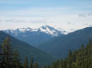
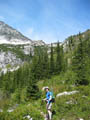
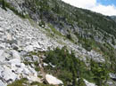
The intersection is just after crossing Chatter Creek on a sturdy bridge. As soon as the old trail is reached the grade doubles in steepness. The next couple miles are steep but very nice trail. I had heard reports of bad grade and overgrown brush but found neither to be a problem. If it was wet the brush could soak you but it is nowhere near blocking a view of the trail. Even the brushy sections are few and short. The several creek crossings were easy. The grade moderated as we entered the high basin of Chatter Creek. We now had views up to the ridges above. This basin is a very worthwhile hike in it's own right.
The trail soon begins the climb up towards the high pass at the end of the valley. The forest gives way to rock, heather, and more wild flowers. Several huge waterfalls cascaded down to the basin. We left the basin at about 5400' and the pass is at about 6650'. We reached the first minor snow of the day at 6200'. It covered the trail for less than 100'. There was a group camping here. Their's was the only other car in the lot when we arrived. Between the 75 Scrambles book and two WTA trip reports we had three quite different descriptions of a route to the summit. The one submitted by Randy seemed the best based on what we saw and it proved to be quite helpful.
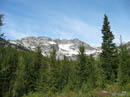
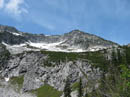
We left the trail just before the final switchbacks to the pass and aimed for a low spot on the ridge just to the left of Point 7112. We skirted just above snow and had open hillside all the way to the top. It was more grass than scree and provided good footing. The ridge top is at 7000'. There was still some snow on the ridge but where we topped out it was bare. From there we dropped down 150' on bare ground to where we met a snowfield. We headed south near the top of the snow and just below cliffs. The snow was soft enough to kick solid steps. We crossed several snowfields with short scree sections in between. This would be much more of a chore when the snow is gone.
We angled slightly uphill on our traverse and come out into a snow filled basin. At this point we had our first view of the summit some 500' above us. This is where the real fun began for me. The snow was softer and more and more rocks protruded. I began to posthole, often up to my waist. We stayed on rock as much as possible but it was not possible to avoid all the soft, thin, crappy snow. We reached the ridge and traversed towards the summit. Although there are several high points Gary had his mind set on the real summit and he was correct. We had rock and snow all the way to just below the summit block. The scrambling was not difficult.
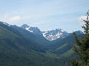
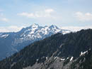
At long last we topped out on the real summit. Clouds were behind Mt. Stuart to the south and blowing in from the west but most of the view was outstanding. The summit register was placed in 1992 and is still only half full. I thought this was a more popular scramble. We were the first to sign in this year. We could see Little Annapurna, Dragontail, Colchuck, Argonaut, Cashmere, and Stuart to the south and southeast. Big Jim Mountain is to the northeast. Cape Horn was to the northwest and Chiwaukum area peaks were to the north. We spent about 40 minutes on top with nearly no wind. The scramble down was much faster. We were back into the snow basin in 15 minutes. Our own steps made the snowfield crossings very fast.
We were back on the bare ridge top in 45 minutes and back on the trail in an hour. From there it's just a nice, though a bit steep, trail walk on out. With all our photo stops it was 7:00 PM by the time we reached the car. We hightailed it out and reached the 59er Diner at 7:55, just before there 8:00 PM closing. This turned out to be one of the best scrambles I have done. It was not technically difficult but had lots of off trail travel, snow, and rock. The summit view is a stunner. The weather turned out great and I am very happy to have chosen this over Dirtyface.
Click on thumbnails to get larger pictures.
Photo Page 2
Trips - 2005
Home
The intersection is just after crossing Chatter Creek on a sturdy bridge. As soon as the old trail is reached the grade doubles in steepness. The next couple miles are steep but very nice trail. I had heard reports of bad grade and overgrown brush but found neither to be a problem. If it was wet the brush could soak you but it is nowhere near blocking a view of the trail. Even the brushy sections are few and short. The several creek crossings were easy. The grade moderated as we entered the high basin of Chatter Creek. We now had views up to the ridges above. This basin is a very worthwhile hike in it's own right.
The trail soon begins the climb up towards the high pass at the end of the valley. The forest gives way to rock, heather, and more wild flowers. Several huge waterfalls cascaded down to the basin. We left the basin at about 5400' and the pass is at about 6650'. We reached the first minor snow of the day at 6200'. It covered the trail for less than 100'. There was a group camping here. Their's was the only other car in the lot when we arrived. Between the 75 Scrambles book and two WTA trip reports we had three quite different descriptions of a route to the summit. The one submitted by Randy seemed the best based on what we saw and it proved to be quite helpful.
We left the trail just before the final switchbacks to the pass and aimed for a low spot on the ridge just to the left of Point 7112. We skirted just above snow and had open hillside all the way to the top. It was more grass than scree and provided good footing. The ridge top is at 7000'. There was still some snow on the ridge but where we topped out it was bare. From there we dropped down 150' on bare ground to where we met a snowfield. We headed south near the top of the snow and just below cliffs. The snow was soft enough to kick solid steps. We crossed several snowfields with short scree sections in between. This would be much more of a chore when the snow is gone.
We angled slightly uphill on our traverse and come out into a snow filled basin. At this point we had our first view of the summit some 500' above us. This is where the real fun began for me. The snow was softer and more and more rocks protruded. I began to posthole, often up to my waist. We stayed on rock as much as possible but it was not possible to avoid all the soft, thin, crappy snow. We reached the ridge and traversed towards the summit. Although there are several high points Gary had his mind set on the real summit and he was correct. We had rock and snow all the way to just below the summit block. The scrambling was not difficult.
At long last we topped out on the real summit. Clouds were behind Mt. Stuart to the south and blowing in from the west but most of the view was outstanding. The summit register was placed in 1992 and is still only half full. I thought this was a more popular scramble. We were the first to sign in this year. We could see Little Annapurna, Dragontail, Colchuck, Argonaut, Cashmere, and Stuart to the south and southeast. Big Jim Mountain is to the northeast. Cape Horn was to the northwest and Chiwaukum area peaks were to the north. We spent about 40 minutes on top with nearly no wind. The scramble down was much faster. We were back into the snow basin in 15 minutes. Our own steps made the snowfield crossings very fast.
We were back on the bare ridge top in 45 minutes and back on the trail in an hour. From there it's just a nice, though a bit steep, trail walk on out. With all our photo stops it was 7:00 PM by the time we reached the car. We hightailed it out and reached the 59er Diner at 7:55, just before there 8:00 PM closing. This turned out to be one of the best scrambles I have done. It was not technically difficult but had lots of off trail travel, snow, and rock. The summit view is a stunner. The weather turned out great and I am very happy to have chosen this over Dirtyface.
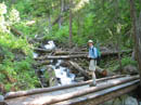
Chatter Creek Bridge |
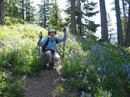
Gary & Lupine |
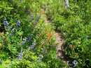
Lupine & Paintbrush |
First View |
View South |
Basin |
Point 7112 |
Valley Wall |
Rising Trail |
Cashmere? |
Photo Page 2
Trips - 2005
Home