2/25-26/05
A snow scramble up Iron Peak is how I usually ring
in spring. On many of my previous trips up I have wondered what it would
be like to camp on top. February may not seem like spring but it sure felt
like it, albeit a little colder at night. I picked up my Hilleberg Nallo
3 last year with a snow trip like this in mind. The weather this "winter"
has been very unusual. Week after week of sunny weather had me ready to give
this trip a go. With another crystal clear weekend forecast I put together
equipment for a winter backpacking adventure. I worked on Monday, Presidents
Day, so I took off Friday.
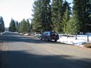
I drove out the North Fork Teanaway Road to the end of pavement at 29 Pines, elevation 2650', and parked. I was ready to go by 9:15. Although there is no snow at the start of the dirt road it is marked "closed". The Forest Service does not want wheels on it while it is soaking wet. Wheel ruts will cause considerable damage. I have pared down my backpacking weight considerably the past two years. For four days in the Goat Rocks this fall I began with a 26 lb. pack. For this winter trip I had 40 lbs. to carry. Snowshoes, shovel, and ice axe alone added up to 6 1/4 lbs. Also my Nallo is 5 1/4 lbs. vs. my tarptent at just under 2 lbs. With snow and sub freezing temperatures I needed the extra weight. The day began cold and clear.
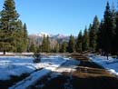
The road was bare for about 3/4 mile. The snow was freshly groomed for snowmobiles without a single mark on it. It was also frozen solid. With the hard packed icy snow I made good time. Even with all the weight I was 3.8 miles down the road to Beverly Creek in 1:17. The snow on the Beverly Creek Road was also compacted by snowmobiles. Finally I began to gain some elevation. I reached the summer parking lot at 5 miles. It was snow covered but only 4 to 5 compacted inches. The foot bridge across the creek was mostly bare. There is a sign stating snowmobiles will voluntarily avoid going across the bridge and up the trail. The next half mile to Bean Creek is on a route compacted by dozens of snowmobiles.
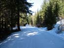
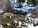
Bean Creek is a bit of an unknown in the spring. I have crossed it on an 8 foot thick snow bridge and waded a wide knee deep torrent. This year it was neither. The day was rapidly warming but the water level was more like you would find in late June. I didn't even bother to put on gaiters before crossing. Once across the creek I was shocked to find stretches of bare dirt. This would be unusual in mid May. The crossing of Bean Creek is at 4000'. Soon the trail was completely snow covered but it averaged 4 to 6 inches deep. I had no trouble staying on the summer trail. The best part of crossing the creek was the end of tracks. I saw no signs of humans all the way to the summit. The trail soon crossed by a large talus field. It was largely snow free.
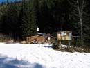
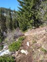
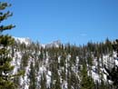
After entering forest at Bean Creek the route changes markedly when it breaks out into the open and nears Beverly Creek. The summer trail soon begins a series of switchbacks climbing higher up the right side of the valley. With snow cover I always choose to stay near the creek. The way is now mostly in the open with clumps of trees. After leaving the forest the snow cover actually thinned. In many places it was only 2 to 5 inches deep. I also crossed some bare dirt patches. At one point higher up the valley I ran into the summer trail again. When the snow suddenly became about a foot deep and very soft I put on snowshoes. The next trick is to get across Beverly Creek. I usually follow along the creek looking for a snow covered log or snow bridge. With my heavy pack I was reluctant to try a snow bridge. When I usually come up this valley in mid April or mid May there is an 8 to 10 foot drop to the creek. This time it was more like 4 to 5 feet. I found a spot where I could step down, cross the creek on a few rocks and climb up the other side. I have never been able to do that in the spring.
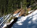
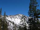
Once across the creek my route is simple. Snowshoe up in thin forest to the base of the final ridge of Iron Peak. This is usually among the best parts of the trip. The snow was very soft and with my heavy pack I was sinking in about 6 inches with every step. This quickly became tiring. My pace slowed way down as I climbed out of the valley. Bill Peak was in view with almost no snow on it's exposed south side. Little Annapurna and McClellan Peak came into view. There was still not a single cloud in the sky. I was down to short sleeves and sweating like mid summer though the temperature was probably in the high 40s. At 3:00 I came out at the base of the final ridge of Iron, just below the summit. There are usually a series of enormous cornices above. The key is to find a route between them. I had planned to camp as high on the mountain as possible to get the best views. I knew that just above the low saddle far right of the summit there is a large flat ridge top plateau. I hoped to start at the summit and come down until I found a good camp site.
With that in mind I began the final 500' climb to the summit ridge. There was 6 to 10 inches of soft snow on top of a hard icy base. At first footing was pretty good. As I ascended the route steepened and the snow became "sugar like". I would have to kick 3 or 4 times with a snowshoe to get down to hard pack where I could get a grip. This made for very slow going. The snow cover was about 80% of normal for April high up. Some rocks were showing through but the depth was much closer to normal than the thin cover at 4000-5000 feet. With about 100 feet to go my leg began to cramp up. I was too close to turn around and somehow continued to the ridge top.
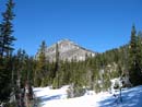
It was 4:00 pm on the ridge. A 500' climb over about 1/4 mile took me an hour. Up on the ridge I dropped my pack and headed higher. A short distance from the summit is a nearly flat area perfect for a camp site. I went back for my pack and began to set up camp. I sank in nearly to my knee with every step making it a chore to level out a tent site. After setting up the tent it was time for dinner. After that it was time to take photos. The snow capped peaks and clear sky made for stunning views. Mt. Stuart was close by. Mt. Daniel appeared heavily snow covered. Rainier and Adams were clearly visible. I had some great sunset colors. As the sun set the temperature plunged. I zipped myself into my tent at 6:20 and it was already 29 degrees. The summit of Iron Peak is 6520'. I was camped about 30 vertical feet below the top at nearly 6500'.
I don't do much snow camping. The nights are just too long. I spent the next 12 hours in my tent. The temperature stayed at about 29 degrees in the tent all night. I should know as I seemed to wake up every hour. I would guess it was in the high teens outside. A 3:30 am bathroom trip was frigid. There was almost a full moon and I could see Mt. Stuart with just moonlight. At 6:30 I awoke to bright sunshine streaming into the tent. I grabbed my frozen solid boots and forced my feet into them. The laces were frozen solid as well. I grabbed my camera for some early morning shots. I then slogged in deep soft snow to the summit. I was surprised to find the summit register was visible. Two separate groups came up in November. I was the first person up this year. Thanks to Slide Alder Slayer for the register. It was dry inside a zip lock bag.
I dove back into my tent as the wind picked up. My thermometer read 40 now. Within an hour it jumped up to 65 degrees as the sun shone on the tent. I really did not want to go out and break camp. I finally did go out and melt snow while breaking camp. By 10:45 I was loaded and ready to head down. I had some of the worst leg cramps ever when I went to bed and had reservations about descending my steep ascent route. I headed farther down the ridge to a lower gentler slope to descend. The snow here was the consistency of sugar again and deep. I slogged knee deep and more without snowshoes on. It was way too soft to glissade. It was slow going but lightning fast compared to my ascent the day before.
The descent down to the creek was quick. I kept snowshoes on until nearly back to the lower forest. When I stopped to take them off I was surprised to see a couple following my footprints up the valley. Jesse and Rachel planned to cross over the saddle of Iron and descend the trail on the other side back to the road. I hope they made it up and over and back before dark. I soon made it back to the summer parking lot and began the long 5 mile road walk. There was remarkable amounts of melting in only one day. At 3:45 I reached my car. The totals were 18 miles with 4200' gained. It turned out to be a strenuous hike with a tremendous payoff in the views. When the conditions are this good I wouldn't mind heading back up again.
Click on thumbnails to get larger pictures.
Photo Page 2
Trips - 2005
Home
I drove out the North Fork Teanaway Road to the end of pavement at 29 Pines, elevation 2650', and parked. I was ready to go by 9:15. Although there is no snow at the start of the dirt road it is marked "closed". The Forest Service does not want wheels on it while it is soaking wet. Wheel ruts will cause considerable damage. I have pared down my backpacking weight considerably the past two years. For four days in the Goat Rocks this fall I began with a 26 lb. pack. For this winter trip I had 40 lbs. to carry. Snowshoes, shovel, and ice axe alone added up to 6 1/4 lbs. Also my Nallo is 5 1/4 lbs. vs. my tarptent at just under 2 lbs. With snow and sub freezing temperatures I needed the extra weight. The day began cold and clear.
The road was bare for about 3/4 mile. The snow was freshly groomed for snowmobiles without a single mark on it. It was also frozen solid. With the hard packed icy snow I made good time. Even with all the weight I was 3.8 miles down the road to Beverly Creek in 1:17. The snow on the Beverly Creek Road was also compacted by snowmobiles. Finally I began to gain some elevation. I reached the summer parking lot at 5 miles. It was snow covered but only 4 to 5 compacted inches. The foot bridge across the creek was mostly bare. There is a sign stating snowmobiles will voluntarily avoid going across the bridge and up the trail. The next half mile to Bean Creek is on a route compacted by dozens of snowmobiles.
Bean Creek is a bit of an unknown in the spring. I have crossed it on an 8 foot thick snow bridge and waded a wide knee deep torrent. This year it was neither. The day was rapidly warming but the water level was more like you would find in late June. I didn't even bother to put on gaiters before crossing. Once across the creek I was shocked to find stretches of bare dirt. This would be unusual in mid May. The crossing of Bean Creek is at 4000'. Soon the trail was completely snow covered but it averaged 4 to 6 inches deep. I had no trouble staying on the summer trail. The best part of crossing the creek was the end of tracks. I saw no signs of humans all the way to the summit. The trail soon crossed by a large talus field. It was largely snow free.
After entering forest at Bean Creek the route changes markedly when it breaks out into the open and nears Beverly Creek. The summer trail soon begins a series of switchbacks climbing higher up the right side of the valley. With snow cover I always choose to stay near the creek. The way is now mostly in the open with clumps of trees. After leaving the forest the snow cover actually thinned. In many places it was only 2 to 5 inches deep. I also crossed some bare dirt patches. At one point higher up the valley I ran into the summer trail again. When the snow suddenly became about a foot deep and very soft I put on snowshoes. The next trick is to get across Beverly Creek. I usually follow along the creek looking for a snow covered log or snow bridge. With my heavy pack I was reluctant to try a snow bridge. When I usually come up this valley in mid April or mid May there is an 8 to 10 foot drop to the creek. This time it was more like 4 to 5 feet. I found a spot where I could step down, cross the creek on a few rocks and climb up the other side. I have never been able to do that in the spring.
Once across the creek my route is simple. Snowshoe up in thin forest to the base of the final ridge of Iron Peak. This is usually among the best parts of the trip. The snow was very soft and with my heavy pack I was sinking in about 6 inches with every step. This quickly became tiring. My pace slowed way down as I climbed out of the valley. Bill Peak was in view with almost no snow on it's exposed south side. Little Annapurna and McClellan Peak came into view. There was still not a single cloud in the sky. I was down to short sleeves and sweating like mid summer though the temperature was probably in the high 40s. At 3:00 I came out at the base of the final ridge of Iron, just below the summit. There are usually a series of enormous cornices above. The key is to find a route between them. I had planned to camp as high on the mountain as possible to get the best views. I knew that just above the low saddle far right of the summit there is a large flat ridge top plateau. I hoped to start at the summit and come down until I found a good camp site.
With that in mind I began the final 500' climb to the summit ridge. There was 6 to 10 inches of soft snow on top of a hard icy base. At first footing was pretty good. As I ascended the route steepened and the snow became "sugar like". I would have to kick 3 or 4 times with a snowshoe to get down to hard pack where I could get a grip. This made for very slow going. The snow cover was about 80% of normal for April high up. Some rocks were showing through but the depth was much closer to normal than the thin cover at 4000-5000 feet. With about 100 feet to go my leg began to cramp up. I was too close to turn around and somehow continued to the ridge top.
It was 4:00 pm on the ridge. A 500' climb over about 1/4 mile took me an hour. Up on the ridge I dropped my pack and headed higher. A short distance from the summit is a nearly flat area perfect for a camp site. I went back for my pack and began to set up camp. I sank in nearly to my knee with every step making it a chore to level out a tent site. After setting up the tent it was time for dinner. After that it was time to take photos. The snow capped peaks and clear sky made for stunning views. Mt. Stuart was close by. Mt. Daniel appeared heavily snow covered. Rainier and Adams were clearly visible. I had some great sunset colors. As the sun set the temperature plunged. I zipped myself into my tent at 6:20 and it was already 29 degrees. The summit of Iron Peak is 6520'. I was camped about 30 vertical feet below the top at nearly 6500'.
I don't do much snow camping. The nights are just too long. I spent the next 12 hours in my tent. The temperature stayed at about 29 degrees in the tent all night. I should know as I seemed to wake up every hour. I would guess it was in the high teens outside. A 3:30 am bathroom trip was frigid. There was almost a full moon and I could see Mt. Stuart with just moonlight. At 6:30 I awoke to bright sunshine streaming into the tent. I grabbed my frozen solid boots and forced my feet into them. The laces were frozen solid as well. I grabbed my camera for some early morning shots. I then slogged in deep soft snow to the summit. I was surprised to find the summit register was visible. Two separate groups came up in November. I was the first person up this year. Thanks to Slide Alder Slayer for the register. It was dry inside a zip lock bag.
I dove back into my tent as the wind picked up. My thermometer read 40 now. Within an hour it jumped up to 65 degrees as the sun shone on the tent. I really did not want to go out and break camp. I finally did go out and melt snow while breaking camp. By 10:45 I was loaded and ready to head down. I had some of the worst leg cramps ever when I went to bed and had reservations about descending my steep ascent route. I headed farther down the ridge to a lower gentler slope to descend. The snow here was the consistency of sugar again and deep. I slogged knee deep and more without snowshoes on. It was way too soft to glissade. It was slow going but lightning fast compared to my ascent the day before.
The descent down to the creek was quick. I kept snowshoes on until nearly back to the lower forest. When I stopped to take them off I was surprised to see a couple following my footprints up the valley. Jesse and Rachel planned to cross over the saddle of Iron and descend the trail on the other side back to the road. I hope they made it up and over and back before dark. I soon made it back to the summer parking lot and began the long 5 mile road walk. There was remarkable amounts of melting in only one day. At 3:45 I reached my car. The totals were 18 miles with 4200' gained. It turned out to be a strenuous hike with a tremendous payoff in the views. When the conditions are this good I wouldn't mind heading back up again.
End Of Pavement |
Earl Peak |
Easy Walking |
Beverly Trailhead |
Bean Creek |
Bare Trail |
Snowy Trail |
Bill Peak |
Mary Peak |
Little Annapurna |
Photo Page 2
Trips - 2005
Home